GNSS
Top 5 best RTK GNSS Receivers for Land Surveying

Finding a good GPS antenna for your land surveying projects can be difficult and time consuming. With more and more brand entering the market won’t make it any easier.
Normally you would have gone to your local dealer and he would tell you he has the best receiver for you, but is this really true? Most local dealers only have 1 to 2 brands and probably just offer you what they want to sell you, not which receiver is best and most cost-effective for you.
As a land surveyor, you and your receiver have to deal with some tough conditions. Your GPS antenna has to be able to deal with these environments. Does that mean that you will need a €10.000 GNSS antenna? No. Nowadays you can get high performance RTK GNSS receivers for around €4000 to €5000. Yes you can get them cheaper but then you really have to ask yourself, do you want to be in a situation where you are standing in a difficult location and your GNSS antenna is not able to get a centimeter accurate fixed location?
Sometimes spending that little extra money on the GNSS receiver will save you on working hours in the long run.
Performance and price are 2 of the key ingredients of finding a good GPS receiver. Of course there are more components that play a role which we take in consideration as well.
Here is our review process in detail:
- Performance
- Price
- Connectivity
- Compatibility
- Features
Top 5 Best RTK GNSS Receivers For Land Surveying in 2025
Below is a list of the top 5 best RTK GNSS receivers for land surveyors that we’ve found perform well in tough conditions with good accuracy and speed.
Please note: As you probably know, a GPS surveying set is not complete without a good surveying software solution. Where the GNSS antenna determines the location its the software that allows you to determine what to do with this location. Wether this is uploading your DTM (digital terrain model) for staking out, or for point collection. In this review we focus on the GNSS antenna only because this is responsible for the performance. Please read the article below for a good software solution:
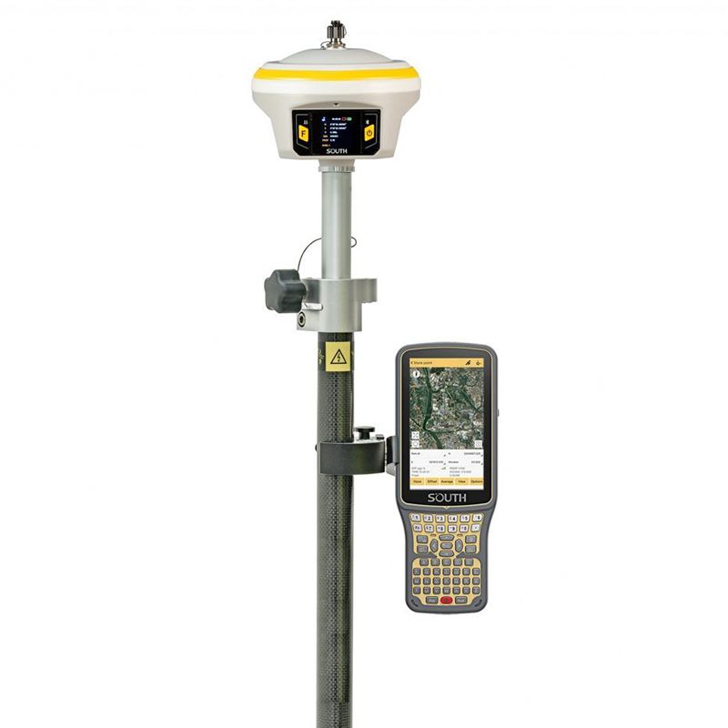
1. South Galaxy G7 – Best Overall
South Galaxy G7 Pros
✅ 1598 Channels
✅ 4G Internet Option
✅ Fast FIX (CM accurate in 5 sec)
✅ Easy to Use Surveying Software
✅ Connect via IP, Bluetooth, Cable
✅ IMU Tilt Sensor (up to 60° angle)
The South Galaxy G7 is a rugged and versatile multi-GNSS RTK receiver with an integrated IMU. It delivers centimeter-level coordinates in RTK mode, which requires a pair of receivers: one stationary to provide corrections and one mobile to apply those corrections for precise location data.
The South Galaxy G7 features a 1598-channel GNSS receiver board. Combined with a VRS RTK subscription from an RTK network, it ensures centimeter accuracy in real-time. Supporting multiple satellite constellations—Galileo, BDS (Beidou), GPS, Glonass, SBAS, IRNSS, and QZSS—the receiver maintains high GNSS accuracy even in challenging conditions.
The built-in IMU compensator in the Galaxy G7 automatically adjusts coordinates based on the tilt direction and angle of the centering rod up to 60°. This allows for quick and accurate surveying or stakeout tasks without leveling the pole, with errors less than 3 cm within a 45° inclination, improving work efficiency by 20%.
Here are some recommended South Galaxy G7 setups

South Galaxy G7 Rover set
A standard RTK GPS set for mapping your terrain, staking out or collecting points.
check options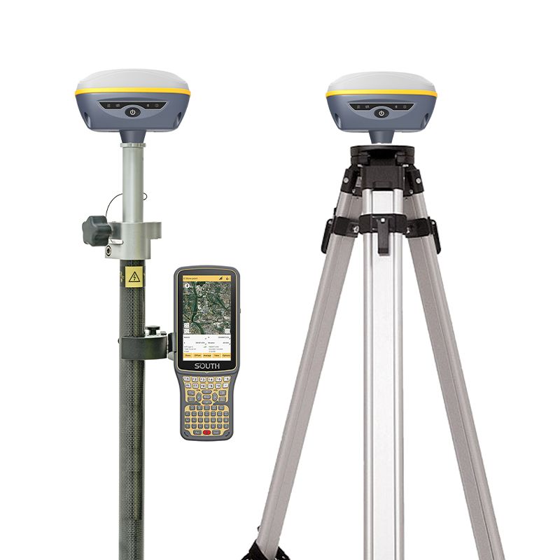
South Galaxy G7 Rover and Base set
When you live in a remote area a second GPS receiver is needed to act as a base station for correction data
check options2. EFIX F8 – Dual Camera Receiver
EFIX F8 Pros
✅ 1608 Channels
✅ Fast FIX (CM accurate in 5 sec)
✅ Dual Camera for Vision Navigation and Stakeout
✅ IMU Tilt Sensor (up to 60° angle)

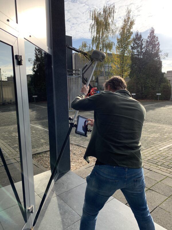
The EFIX F8 seamlessly integrates cutting-edge VISION, GNSS, and IMU technologies to meet the exacting standards of professional surveyors. It provides unparalleled accuracy and efficiency for surveying tasks. Equipped with dual cameras, the F8 features an advanced vision system that enables surveyors to easily overcome obstacles and navigate challenging terrains, including hard-to-reach, difficult-to-fix, and hazardous points. Additionally, its real-time visual feedback capabilities allow for precise stakeout procedures without the need for complex offset methods, resulting in increased efficiency and precision.
Easily obtain high-precision 3D coordinates from real-time video, enabling accurate measurements of challenging scenes, including signal-obscured, hard-to-reach and hazardous points. High-speed dynamic panoramic shooting, high-quality and distortion-free image capture, automated image matching with up to 85% overlap rate.

Fully integrated GNSS+IMU+Camera for greater efficiency
- Remain good accuracy even when the F8 is not held plumb. You can hold the receiver in a 60° degrees angle and remain centimeter accurate.
- Reach to where it is difficult or dangerous to do centering, or just when you want to be spared from it. Spots under cars, next to trees or on slopes are not difficult to measure anymore. With the IMU tilt sensor of the EFIX F8 you can easily measure those hard to reach and often dangerous points.
- Immersive AR Visual Stakeout to vividly display ground stakeout points in the eField software, increasing efficiency by 50%.
Here are some recommended EFIX F8 setups

EFIX F8 Rover set
A standard RTK GPS set for mapping your terrain, staking out or collecting points.
Check options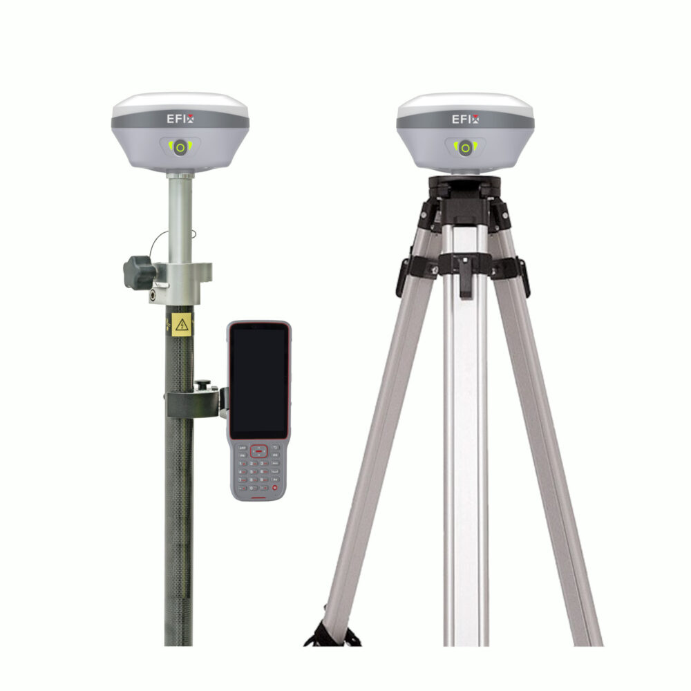
EFIX F8 Rover and Base set
When you live in a remote area a second GPS receiver is needed to act as a base station for correction data.
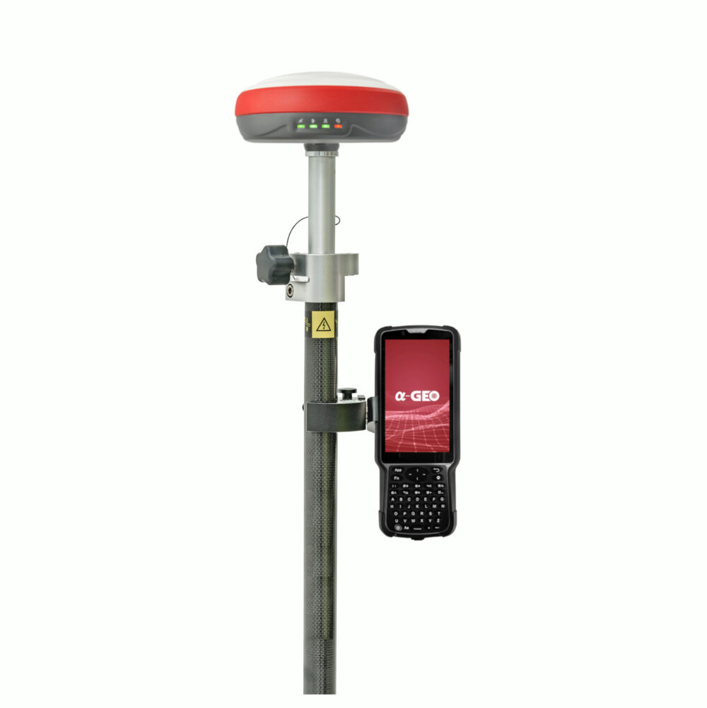
Check options3. a-GEO L300 – Good performance
a-GEO L300 Pros
✅ 1408 Channels
✅ 4G internet
✅ Fast FIX (CM accurate in 5 sec)
✅ Connect via IP, Bluetooth, Cable
✅ E-bubble and IMU tilt sensor (up to 60° angle)
The L300 GNSS receiver, featuring a 1408-channel new generation full GNSS chipset, supports multiple satellite constellations including GPS, GLONASS, BEIDOU, GALILEO, QZSS, SBAS, and IRNSS. This multi-constellation capability ensures precise and accurate spatial data for users worldwide. Additionally, the L300 functions as a WiFi hotspot, allowing users to easily access and manage its status, configure settings, or download static and PPK raw data through an advanced WebUI on any WiFi-enabled device, eliminating the need for third-party software or cables.
Equipped with a state-of-the-art IMU tilt sensor, the L300 offers fast initialization and calibration-free operation, immune to magnetic interference. This enables users to collect or stakeout topo points at angles up to 60°. Furthermore, the L300 features a built-in 4G module for fast internet connectivity, ensuring efficient reception of correction data across all telecommunication signals and bands. The integrated Tx/Rx internal UHF radio, with a frequency range of 410 MHz to 470 MHz, provides reliable real-time data collection in Base/Rover mode.
Designed for durability and long field use, the L300 boasts a high-quality magnesium alloy body, providing a lightweight yet rugged option for professional surveyors. With an IP67 rating, it withstands harsh conditions without compromising quality. The internal 6800mAh lithium-ion battery supports USB type-C fast charging, offering over nine hours of operation. The L300 supports various working modes, including Static, Network RTK, UHF RTK, and PPK, making it a versatile tool for diverse surveying projects.

a-GEO L300 Rover set
A standard RTK GPS set for mapping your terrain, staking out or collecting points.
check options
a-GEO L300 Rover and Base set
When you live in a remote area a second GPS receiver is needed to act as a base station for correction data.
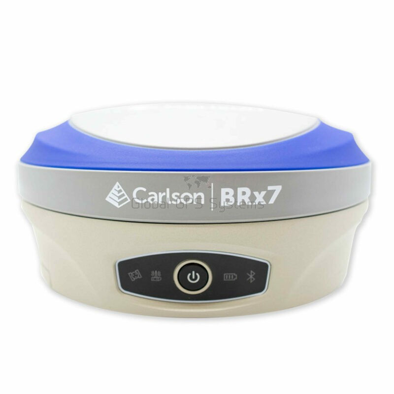
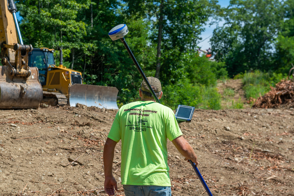
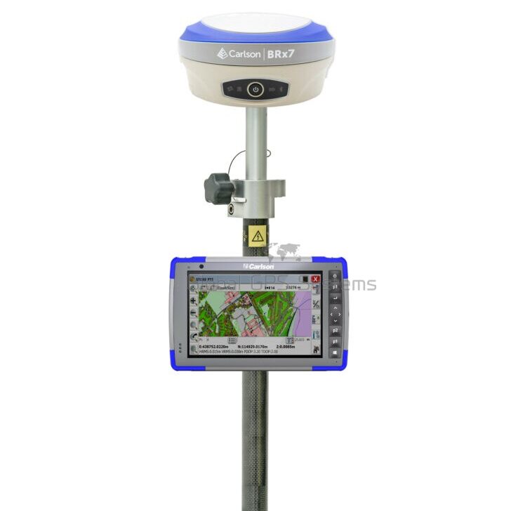
check options4. Carlson BRx7 – High-End Receiver
Carlson BRx7 Pros
✅ 4G internet
✅ Fast FIX (CM accurate in 5 sec)
✅ With removable dual battery, for single
battery parameter: 7.2 V, 3400 mAh, 24.48 Wh
✅ E-bubble and IMU tilt sensor (up to 60° angle)
✅ 800+ Channels
✅ Hemisphere board with full constellation support
Carlson was founded in 1983 in America and specializes in field data collection, machine control products and CAD design software for all surveying markets worldwide.
It’s easy to say that the Carlson BRx7 RTK GNSS receiver is their flagship product when it comes to hardware. With its 800+ channels you know this RTK GNSS receiver gets the job done. The price is indeed a little higher than most RTK GPS receivers but you’ll be able to go surveying almost anywhere with confidence.
The Carlson BRx7 GNSS receiver also has an IMU tilt sensor which can tilt up to 60° with a compensation of 5 cm. So also with this GPS receiver surveying in difficult enviroments is no problem at all. If, because of any reason, you’re not able to connect with a local RTK or CORS solution and you don’t want to set up a base station, you’ll have the option to use the Atlas L-Band correction data anywhere you want.
With the removable dual battery, with a working time of 12 hours, you’re able to just change the batteries in the RTK GNSS receiver when they run dry. So even if your batteries run dry on the job you don’t have to quit surveying that day to come back the next day. Just swap the empy batteries for the fully charged ones and continue your surveying.
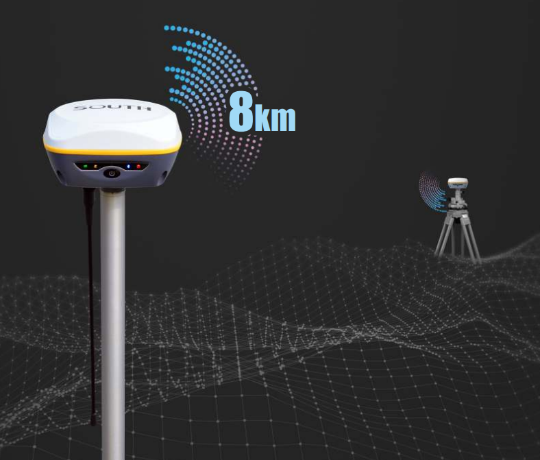
If you are planning to use the Carlson BRx7 GNSS receiver in a rover and base set up you’ll have the ability to use their industry-leading unique cloud-based service that eliminates baseline length restriction of UHF radio’s, Carlson’s Listen-Listen. With this service your RTK GPS receiver will have RTK baselines up to 50 km with fast acquisition times.
Here are some recommended Carlson BRx7 setups
Carlson BRx7 Rover set
A standard RTK GPS set for mapping your terrain, staking out or collecting points.
Check options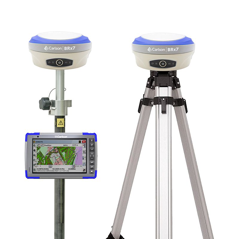
Carlson BRx7 Rover and Base set
When you live in a remote area a second GPS receiver is needed to act as a base station for correction data.
Check options5. South Insight V3 – Dual Camera Receiver
South Insight V3 PROS
✅ 1698 Channels
✅ 4G Modem
✅ Dual Camera for Vision Navigation and Stakeout
✅ E-bubble and IMU tilt sensor (up to 60° angle)
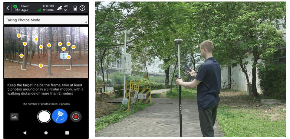
Introducing the INSIGHT V3, a cutting-edge GNSS receiver designed to enhance productivity and performance. With 1698 channels, it excels in tracking satellites and weak signals, ensuring rapid fixed solutions even in dense forests and urban areas. Its Dual Camera AR Stakeout feature allows seamless point, line, and curve stakeouts using front and bottom cameras. The INSIGHT V3’s dual-engine GNSS positioning algorithms provide real-time error correction, and the enhanced Farlink 2.0 radio ensures stable data transmission over distances up to 12 km. The latest IMU update maintains workflow efficiency during AR stakeout and 3D modeling. Elevate your geospatial tasks with the INSIGHT V3, featuring five innovative elements for unmatched productivity.
The INSIGHT V3 processes photos or videos in real-time, obtaining coordinates for hundreds of points within minutes. It surpasses traditional RTK in data acquisition speed and offers a broader working range with fewer blind spots. This enables remote measurements in areas with poor GNSS signal quality, such as under rooftops and around obstacles, making it more user-friendly than conventional RTK systems. Its visual positioning capabilities allow surveyors to measure points remotely up to 10 meters or more under ideal conditions, reducing the physical effort required in fieldwork. The collected image data is stored for extended periods, making it reusable for unique GNSS measurement tasks, like documenting accident scenes and excavation sites for urban public facilities.
The INSIGHT V3’s versatility is enhanced by SOUTH’s 3D modeling technology, which integrates image measurements with UAV data from DJI and other brands to fill gaps in UAV surveys. This improves survey outcomes by supplementing incomplete models with ground image data. Surveyors can incorporate INSIGHT V3 data into SOUTH software and third-party modeling software for efficient 3D modeling. Upcoming versions of SGO (PC) and SurvStar (Android App) will include 3D modeling functions, allowing users to choose the best software for their specific scenarios and tasks, thus broadening their working capabilities.
Here are some recommended South Insight V3 setups

South Insight V3 Rover set
A standard RTK GPS set for mapping your terrain, staking out or collecting points.
Check options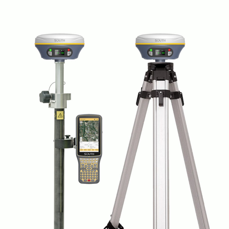
South Insight V3 Rover and Base set
When you live in a remote area a second GPS receiver is needed to act as a base station for correction data.
Check optionsThings to consider when choosing an RTK GPS receiver for land surveying
1. Besides The GPS Antenna You Will Need Surveying Software As Well
With just a GNSS receiver you are not going to get far. Yes the GPS antenna provides you with the positioning data and the accuracy that you need but you’ll still need a place to process all of this.
This is what land surveying software is for. Within the software you can attach data to your GPS positioning data. By uploading DTM (Digital Terrain Models) into your software you can stake out these points based on the positioning data your GPS system provides.
The receivers listed above are all compatible with most of the GPS survey software packages so connecting should not be an issue. Now the questions remains, Which software package do I need? You can read the article below to find a good solution:
2. Know which GNSS receiver setup you will need
Most land surveyors nowadays use a correction service to make your GPS receiver centimeter accurate. Without a correction source your GNSS antenna will never be centimeter accurate.
Because they they use this, setting up your own base station is not needed anymore. Most land surveyors will go for a setup which is called a Rover setup.
This setup normally consists of:
- RTK GNSS receiver with internet capabilities;
- Data collector with land surveying software
- Surveying pole with bracket for data collector
- Correction data from a source like RTK FIX