

GNSS
Top 5 best RTK GNSS Receivers for Land Surveying
Last updated: May 2026
Finding the best RTK GNSS receiver for land surveying is becoming increasingly difficult. The GNSS market has exploded over the last few years, with more manufacturers entering the industry and dozens of new receivers being launched every year. While having more choice is generally a good thing, it also makes selecting the right GPS surveying equipment far more complicated.
In the past, most surveyors would simply visit their local surveying equipment dealer and purchase whatever brand was available. The problem is that many dealers only work with one or two manufacturers, which means the advice you receive is often based more on sales agreements than actual field performance.
Choosing the wrong RTK GNSS receiver can have a major impact on productivity in the field. A receiver that struggles under tree canopy, loses RTK fix in difficult environments, or performs poorly near buildings can quickly cost you valuable working hours. While cheaper GNSS antennas may look attractive initially, they often become expensive in the long run when accuracy and reliability start affecting daily operations.

For professional land surveyors, performance should always be the highest priority. Your GNSS receiver needs to perform consistently in challenging environments while maintaining fast RTK initialization and stable centimeter-level accuracy. That does not necessarily mean you need to spend €15,000 or more on a premium surveying receiver.
Modern RTK GNSS technology has improved dramatically, and there are now several high-performance receivers available in the €4,000 to €6,000 price range that deliver excellent results in professional surveying applications. In this article, we compare some of the best RTK GNSS receivers for land surveying in 2026 based on real-world usability, performance, pricing, connectivity, compatibility, and overall value for money.
How We Selected the Best RTK GNSS Receivers
When reviewing GNSS surveying equipment, specifications alone do not tell the full story. Many receivers look impressive on paper but perform very differently in difficult field conditions. For this reason, we focused primarily on real-world surveying performance rather than marketing specifications.
The most important factors we considered include RTK fix stability, satellite tracking capability, performance under canopy, initialization speed, radio and internet connectivity, software compatibility, battery life, durability, and overall reliability in demanding surveying environments. Price also plays a major role. Surveyors need equipment that offers a strong balance between cost and productivity. Spending slightly more on a better-performing GNSS receiver can often save hundreds of working hours over the lifespan of the equipment.
What Makes a Good RTK GNSS Receiver?
It is important to understand that a modern surveying setup consists of far more than just the GNSS receiver itself. While the RTK GNSS receiver determines the position and overall accuracy, the surveying software controls nearly everything else in the workflow. Modern field software handles tasks such as point collection, stakeout, CAD visualization, coordinate systems, DTM handling, linework, and project management. But today’s surveying workflows go even further. New technologies such as IMU tilt compensation, GNSS receivers with integrated laser measurement, stake-out cameras, LiDAR scanning, and drone photogrammetry all depend heavily on software integration.
For example, IMU tilt compensation allows surveyors to measure points without leveling the survey pole, while stake-out cameras visually guide operators directly to layout points. Some advanced GNSS receivers now even include integrated laser systems for measuring inaccessible locations remotely. Meanwhile, LiDAR and photogrammetry workflows generate massive amounts of spatial data that must be processed, visualized, and managed efficiently through software.
This means that even the best RTK GNSS receiver can feel limited if it is paired with poor or outdated field software. Fast and reliable hardware is important, but smooth workflows, stability, compatibility, and ease of use are just as critical for productivity in the field. When selecting new surveying equipment, surveyors should always evaluate both the GNSS hardware and the software ecosystem together.
Top 5 Best RTK GNSS Receivers For Land Surveying in 2026
Below is a list of the top 5 best RTK GNSS receivers for land surveyors that we’ve found perform well in tough conditions with good accuracy and speed.
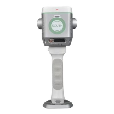
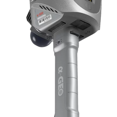
1. South Supreme ME
The GNSS receiver that still has a 1 cm FIX under a roof!
The South Supreme ME takes the number one position because it solves one of the biggest limitations in traditional GNSS surveying: losing accuracy when satellite coverage disappears.
Most RTK receivers perform well under open skies, but the moment you move under a roof, inside a building, beneath a bridge, or into a dense urban environment, productivity drops fast. Surveyors are forced to stop working, switch equipment, or return later when conditions improve. The South Supreme ME changes that completely.
What makes this receiver stand out is its innovative Magic Calculation (Mixed Solution) technology. By combining GNSS RTK positioning with integrated LiDAR scanning, IMU sensors, and intelligent environmental calculations, the receiver can continue measuring accurately even in places where there is little or no satellite fix. This is a major breakthrough for the surveying industry.


The South Supreme ME is not just another GNSS receiver with a few extra features. It introduces an entirely new way of surveying. Users can seamlessly transition between outdoor and indoor environments without interrupting their workflow. Point collection, line measurement, and even stake-out operations remain possible in satellite-denied areas — something very few receivers on the market can currently achieve reliably.
Another reason the South Supreme ME earns the top position is its impact on productivity. Surveyors spend less time waiting for signal recovery and far less time revisiting difficult areas. Construction layout work becomes faster, industrial surveys become easier, and indoor mapping workflows become far more efficient. For companies working in construction, infrastructure, utilities, and engineering, this translates directly into saved time and lower operational costs.
The integrated LiDAR system also gives the receiver a significant advantage over conventional RTK equipment. Instead of relying purely on satellite visibility, the South Supreme ME continuously understands its surroundings and uses that information to maintain accurate positioning. This allows surveyors to keep working in tunnels, warehouses, covered construction sites, and dense city environments where standard GNSS receivers struggle.
In terms of innovation, few receivers currently push the industry forward as aggressively as the South Supreme ME. While many manufacturers focus mainly on improving satellite tracking or tilt compensation, South has developed a hybrid positioning solution that genuinely expands where and how surveyors can work.
For professionals looking for the most advanced GNSS receiver available today, the South Supreme ME delivers the perfect combination of RTK precision, LiDAR technology, indoor capability, and real-world productivity improvements. That is why it deserves the number one spot on this list of the best GNSS receivers.


2. EFIX F8L
The Best GNSS receiver for Visual Stake-Out and Laser Surveying
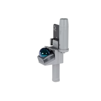
The EFIX F8L earns the number two position on this list because it focuses on something that directly improves everyday field productivity: making surveying faster, easier, and more intuitive through visual stake-out technology and integrated laser measurement.
While many GNSS receivers compete mainly on satellite tracking and accuracy specifications, the EFIX F8L stands out by improving the actual user experience in the field. Its integrated stake-out camera allows surveyors to visualize points and lines directly on the controller screen, making stake-out work dramatically simpler and more efficient. Instead of relying purely on directional arrows and numerical guidance, users can see exactly where the target is located in real time.
This feature becomes especially valuable on busy construction sites, infrastructure projects, and complex layouts where traditional stake-out workflows can be time-consuming and frustrating. The camera-based guidance helps surveyors reach points faster, reduces mistakes, and makes the entire process easier for both experienced professionals and newer field crews.


GPS & GNSS
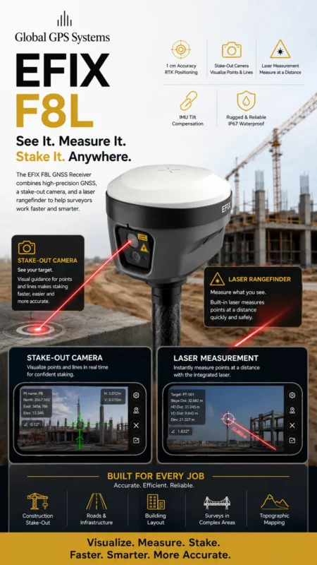
Another major advantage of the EFIX F8L is its integrated laser rangefinder. This allows users to measure points at a distance without physically occupying the target location. In real-world surveying conditions, this can save enormous amounts of time and improve safety when measuring inaccessible or hazardous areas.
Instead of climbing over obstacles or entering difficult locations, surveyors can simply aim and capture measurements remotely using the built-in laser system. This is particularly useful for construction layout, facade measurements, topographic surveys, industrial sites, and infrastructure inspections.
The EFIX F8L also delivers strong RTK performance with reliable centimeter-level accuracy, fast initialization times, and stable positioning in demanding environments. Combined with IMU tilt compensation, the receiver allows users to measure efficiently without constantly leveling the pole, helping speed up workflows even further.
What makes the EFIX F8L particularly impressive is how well it balances innovation, usability, and value. It introduces advanced technologies that genuinely improve field operations without becoming overly complicated to use. The receiver feels modern, practical, and designed around real surveyor workflows rather than just technical specifications.
For surveyors who want faster stake-out operations, smarter visual guidance, and the convenience of integrated laser measurements, the EFIX F8L is one of the most complete and productivity-focused GNSS receivers currently available. That is exactly why it deserves the number two spot on this list of the best GNSS receivers.


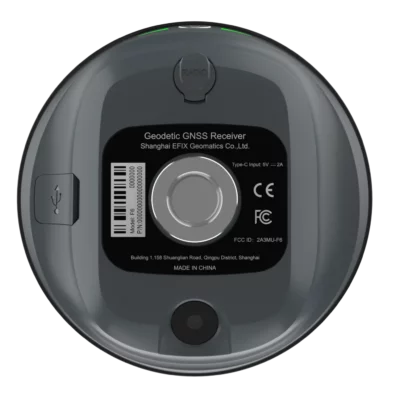
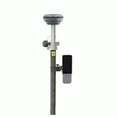
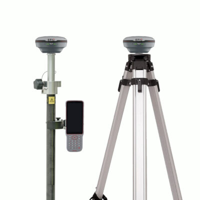
3. EFIX F6
The Best Lightweight GNSS Receiver for Everyday Surveying
The EFIX F6 earns its place on this list because it combines professional RTK performance with one of the most lightweight and practical designs currently available on the GNSS market. For surveyors who spend long days in the field, portability and ease of use matter just as much as raw technical specifications — and this is exactly where the EFIX F6 excels.
One of the biggest advantages of the EFIX F6 is its ultra-lightweight construction. Weighing significantly less than many traditional GNSS receivers, the F6 is designed for surveyors who are constantly moving between points, construction layouts, and topographic measurements. Carrying lighter equipment throughout the day reduces fatigue, improves comfort, and helps crews work more efficiently over long periods in the field.
Despite its compact size, the EFIX F6 still delivers reliable centimeter-level RTK accuracy and fast satellite tracking performance. The receiver supports full constellation tracking and provides stable positioning for a wide range of surveying applications, including construction stake-out, topographic surveys, GIS mapping, and infrastructure projects.
GPS & GNSS
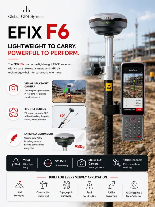
What makes the EFIX F6 particularly modern is its integrated visual stake-out camera. Traditional stake-out workflows often rely heavily on numerical guidance and directional arrows, which can slow down field operations. The F6 improves this process by allowing surveyors to visually see stake-out targets directly on the controller screen. This makes stake-out tasks faster, more intuitive, and easier to understand in real-world environments.
The visual guidance system is especially useful on busy construction sites where operators need quick and accurate positioning while working around obstacles, machinery, and complex layouts. By making stake-out more visual and user-friendly, the EFIX F6 helps improve productivity and reduce mistakes during layout operations.
Another major strength of the receiver is its advanced IMU tilt compensation technology. With the built-in IMU sensor, surveyors can measure accurately even when the pole is tilted significantly. This eliminates the constant need to perfectly level the pole and allows users to capture points more quickly in difficult or obstructed locations.
In practice, this creates a much smoother surveying workflow. Users can measure corners, fences, walls, and hard-to-reach points faster while maintaining reliable accuracy. Combined with the lightweight design, the IMU technology makes the EFIX F6 an extremely efficient receiver for everyday fieldwork.
The EFIX F6 also stands out because of its balance between affordability, usability, and modern features. It offers many of the advanced capabilities normally found in larger and more expensive GNSS systems while remaining compact, lightweight, and easy to operate.
For surveyors looking for a highly portable GNSS receiver with visual stake-out functionality, reliable IMU tilt compensation, and professional RTK performance, the EFIX F6 delivers outstanding value. Its combination of lightweight design and productivity-focused technology makes it one of the best all-around surveying receivers available today — and a deserving addition to this top GNSS ranking.


4. FJDynamics Trion V4E Pro
The Affordable Handheld GNSS Receiver
The FJDynamics Trion V4E Pro earns the number four position on this list because it delivers an impressive combination of affordability, portability, and practical surveying functionality in a compact handheld device.
While many professional GNSS receivers focus on high-end enterprise workflows, the Trion V4E Pro stands out by making modern RTK surveying technology far more accessible. It is one of the most affordable handheld GNSS receivers on the market that still offers professional-grade point collection and stake-out capabilities with centimeter-level accuracy.
What makes the V4E Pro especially attractive is its lightweight handheld design. Unlike traditional pole-mounted RTK receivers, the device is designed to be operated comfortably in one hand, making it ideal for fast fieldwork, quick measurements, and mobile surveying tasks. This creates a much more flexible workflow for surveyors, utility workers, construction professionals, and GIS users who need speed and simplicity in the field.


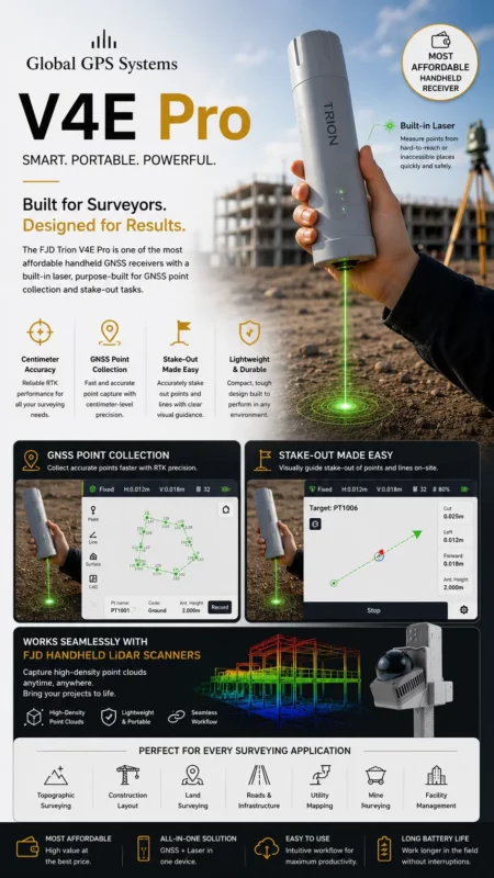
Another major advantage of the FJDynamics Trion V4E Pro is its integrated laser measurement system. The built-in laser allows users to collect points remotely and safely without physically occupying the target location. In real-world surveying conditions, this becomes extremely useful for measuring inaccessible areas, hazardous locations, building facades, fences, corners, and objects that would normally slow down conventional surveying workflows.
The receiver is also highly effective for GNSS point collection and stake-out applications. Users can quickly capture accurate survey points and perform layout tasks with a simple and intuitive workflow. Because of its compact design and ease of use, the Trion V4E Pro is particularly appealing for professionals who want efficient RTK functionality without carrying heavy equipment into the field.
One of the most innovative aspects of the V4E Pro is its ability to integrate seamlessly with the FJD handheld LiDAR scanner ecosystem. By combining the GNSS receiver with FJD’s portable LiDAR solutions, users can create detailed point clouds and capture spatial data for advanced mapping and 3D documentation projects.
This combination opens the door to workflows that were previously only possible with far more expensive systems. Surveyors can move from simple RTK point collection to full point-cloud capture using lightweight handheld equipment that is easy to transport and operate.
The FJDynamics Trion V4E Pro also deserves recognition for bringing modern surveying technology to a wider audience. It lowers the barrier to entry for professionals who want accurate GNSS positioning, laser measurement, and LiDAR-ready workflows without investing in extremely expensive hardware.
For surveyors looking for an affordable, portable, and highly versatile handheld GNSS receiver, the FJDynamics Trion V4E Pro offers exceptional value. Its combination of RTK positioning, laser point collection, stake-out functionality, and LiDAR integration makes it one of the most innovative budget-friendly surveying solutions available today — and a clear choice for the number four spot on this list.

5. Alpha Geo Falcon X
The Best RTK + SLAM Hybrid for Point Clouds and GNSS-Denied Environments
The Alpha Geo Falcon X earns the number five position on this list because it brings together traditional RTK surveying and modern SLAM LiDAR technology into one powerful hybrid solution. Designed for professionals who work in complex environments, the Falcon X allows surveyors to continue collecting accurate spatial data even in locations where normal GNSS receivers lose satellite coverage.
What makes the Falcon X especially interesting is its ability to combine GNSS positioning, LiDAR scanning, and SLAM technology into a single workflow. Traditional RTK receivers work extremely well outdoors with clear satellite visibility, but they struggle under bridges, inside buildings, in tunnels, or beneath dense structures. The Falcon X solves this problem by using LiDAR-based positioning and SLAM algorithms to continue mapping and measuring in environments where GNSS alone is no longer sufficient.
GPS & GNSS

This makes the Falcon X particularly valuable for infrastructure projects, bridge inspections, underground construction, industrial facilities, and indoor mapping applications. Surveyors can seamlessly transition between outdoor RTK surveying and indoor or covered-area scanning without interrupting the workflow or switching equipment.
One of the biggest advantages of the Falcon X is its ability to generate real-time point clouds while simultaneously maintaining accurate positioning data. Instead of only collecting individual survey points, users can capture entire environments as detailed 3D spatial datasets. This dramatically improves efficiency on projects where large amounts of data need to be captured quickly and accurately.
The LiDAR system continuously scans the surrounding environment while SLAM technology calculates positioning based on movement and environmental features. This allows surveyors to walk through complex spaces and generate dense point clouds in real time, even beneath bridges or in areas with little or no satellite visibility.
Another major strength of the Falcon X is its versatility. The system can be used both as a traditional RTK rover and as a handheld SLAM scanner, giving users flexibility depending on the project requirements. This hybrid approach makes it suitable for a wide range of surveying and mapping tasks, from construction verification and utility documentation to BIM modeling and infrastructure inspection.
The Falcon X also stands out because it represents the future direction of the surveying industry. Modern projects increasingly demand more than just single-point measurements. Clients now expect complete digital twins, 3D environments, and high-density spatial datasets. By combining RTK positioning with LiDAR point-cloud generation, the Falcon X helps surveyors move toward these next-generation workflows.
While it may not replace a dedicated high-end terrestrial laser scanner for every application, the Falcon X offers an impressive balance between mobility, speed, and functionality. It allows surveyors to capture complex environments far more efficiently than with traditional GNSS workflows alone.
For professionals looking to combine RTK surveying with portable SLAM LiDAR scanning and real-time point-cloud generation, the Alpha Geo Falcon X offers a highly innovative solution. Its ability to work in GNSS-denied environments, collect dense spatial data, and bridge the gap between surveying and 3D reality capture makes it a deserving addition to this list of the best GNSS systems available today.
Things to consider when choosing an RTK GPS receiver for land surveying
1. Besides The GPS Antenna You Will Need Surveying Software As Well
With just a GNSS receiver you are not going to get far. Yes the GPS antenna provides you with the positioning data and the accuracy that you need but you’ll still need a place to process all of this.
This is what land surveying software is for. Within the software you can attach data to your GPS positioning data. By uploading DTM (Digital Terrain Models) into your software you can stake out these points based on the positioning data your GPS system provides.
The receivers listed above are all compatible with most of the GPS survey software packages so connecting should not be an issue. Now the questions remains, Which software package do I need? You can read the article below to find a good solution:
2. Know which GNSS receiver setup you will need
Most land surveyors nowadays use a correction service to make your GPS receiver centimeter accurate. Without a correction source your GNSS antenna will never be centimeter accurate.
Because they they use this, setting up your own base station is not needed anymore. Most land surveyors will go for a setup which is called a Rover setup.
This setup normally consists of:
- RTK GNSS receiver with internet capabilities;
- Data collector with land surveying software
- Surveying pole with bracket for data collector
- Correction data from a source like RTK FIX