


Beginner’s Guide to Buying Your First GPS Surveying Set
Buying your first GPS surveying set can be confusing. This beginner’s guide explains what a [...]
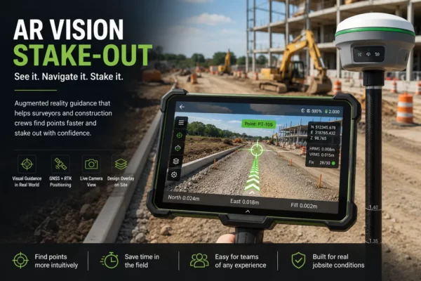
AR Vision Stake-Out: How Augmented Reality Makes GNSS Stakeout Easier in the Field
AR vision stake-out uses GNSS positioning, camera views and augmented reality guidance to help surveyors [...]

Lidar vs Radar: Differences, Advantages and Disadvantages
In the realm of sensing technologies, Lidar and Radar have emerged as key players, each [...]

When Was GPS Invented? The Evolution of GPS and GNSS Technology
GPS began as a military satellite navigation project and became one of the most important [...]

Total Station Guide: Which Total Station Do I Need?
Choosing the right total station or theodolite for your surveying or construction project is a [...]
Top 3 Most Important Accessories for Total Stations
In the world of land surveying and construction, total stations are indispensable tools, and the [...]

What is a Robotic Total Station?
In a domain where precision and efficiency are paramount, Robotic Total Stations emerge as game-changers. [...]
Land Surveyor: Exploring the Role, Salary, and Path to Success
Land surveying is an exciting and rewarding profession that offers a blend of fieldwork and [...]

GNSS Surveying Methods: Exploring Accuracy and Techniques
GNSS surveying methods offer a wide range of accuracy levels and techniques to meet the [...]

Enhancing GNSS Surveying with Augmented Reality: A Revolutionary Stakeout Technique
Augmented Reality is transforming the field of GNSS surveying stakeouts, providing surveyors with unprecedented visualization [...]

What Is SBAS in GNSS? Accuracy and Field Uses
SBAS improves standard GNSS positioning by sending correction and integrity data from regional satellite systems [...]