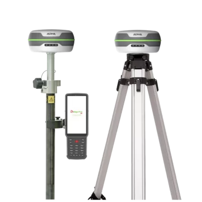
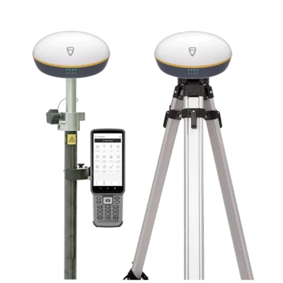
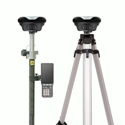
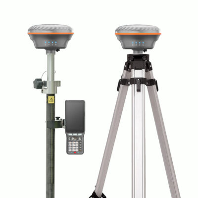
GNSS Rover and Base sets
Compare complete RTK GPS and GNSS rover-base sets for surveying, construction layout, mapping and stake-out work. A rover-base setup includes two receivers: one fixed base station and one mobile rover, allowing you to work independently from RTK networks or NTRIP correction services. Rover-base sets are ideal for remote areas, private construction sites, poor internet coverage or locations without reliable RTK network access. Choose from modern GNSS systems with IMU tilt compensation, UHF radio, visual stake-out, laser measurement and advanced RTK performance.
Global GPS Systems
4.73 store rating (567 reviews) | 4.68 product rating
Login to view pricing or to request a quote
Log in
Login to view pricing or to request a quote
Log in
Login to view pricing or to request a quote
Log in
Login to view pricing or to request a quote
Log in
Login to view pricing or to request a quote
Log in
Login to view pricing or to request a quote
Log in
Login to view pricing or to request a quote
Log in
Login to view pricing or to request a quote
Log in
Login to view pricing or to request a quote
Log in
Login to view pricing or to request a quote
Log in
Login to view pricing or to request a quote
Log in
Login to view pricing or to request a quote
Log in
Login to view pricing or to request a quote
Log in
Login to view pricing or to request a quote
Log in
Login to view pricing or to request a quote
Log in
Login to view pricing or to request a quote
Log in
Login to view pricing or to request a quote
Log in
Login to view pricing or to request a quote
Log in
Login to view pricing or to request a quote
Log in
Login to view pricing or to request a quote
Log in
GPS Rover-Base Sets
GPS rover-base sets, also called GNSS rover-base sets or RTK base and rover systems, are complete surveying setups that include two GNSS receivers. One receiver is used as the base station and the other receiver is used as the rover in the field. This setup is ideal when you need centimetre-level RTK accuracy but do not want to depend on an RTK network, NTRIP correction service or mobile internet connection. Rover-base sets are commonly used by land surveyors, construction companies, engineers, drone surveyors, utility mapping teams, agriculture specialists and infrastructure professionals.
What is a GPS Rover-Base Set?
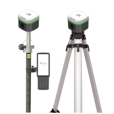
A GPS rover-base set uses two GNSS receivers. The base receiver is placed on a fixed position, such as a known control point, tripod or site benchmark. The rover receiver is then used to collect points, stake out designs or measure features across the project area. The base station calculates correction data and sends it to the rover. This correction data allows the rover to calculate accurate RTK positions in real time. Depending on the system, correction data can be sent by UHF radio, external radio, internet connection or another supported communication method.
When Do You Need a Rover and Base Setup?
A rover-base setup is recommended when there is no reliable RTK network available in your working area. It is also useful when mobile internet coverage is poor, when you work in remote locations, or when you want to operate independently from third-party correction services. Many surveyors also use rover-base sets on private construction sites, infrastructure projects, quarries, agricultural land, mining sites, marine projects and large rural areas. In these situations, your own base station gives you more control over the correction source and the working area.
Rover-Base Set or Rover Only?
A rover-only GNSS set is usually the best choice when you have access to a reliable RTK network, VRS network, CORS network or NTRIP correction service. In that setup, one receiver is used as the rover and receives correction data through the internet. A rover-base set is the better choice when you cannot rely on an RTK network or mobile internet. With your own base station, you create a local correction source for the rover. This makes rover-base systems especially useful for remote projects, temporary job sites and areas with limited network coverage.
How Does an RTK Base and Rover System Work?
The base receiver remains fixed in one position during the survey. It receives satellite signals and calculates correction data from its known or fixed location. This correction data is then sent to the rover receiver. The rover uses the correction data from the base station to improve its own position. This makes it possible to achieve centimetre-level accuracy for point collection, stake-out, construction layout and mapping workflows. Most rover-base sets communicate by UHF radio, internal radio modem, external radio or internet-based correction transfer. The best option depends on the distance between the base and rover, the terrain, local radio regulations, internet coverage and the type of work being carried out.
What are GPS Rover-Base Sets Used For?
RTK GPS rover-base sets are used for land surveying, construction layout, road work, utility mapping, earthworks, agriculture, mining, drainage, infrastructure projects and drone mapping. They are suitable for measuring boundaries, collecting terrain points, staking out foundations, mapping cables and pipes, checking levels, placing Ground Control Points for drone surveys and creating accurate field data for CAD, GIS or machine control workflows.
Important Features in Modern Rover-Base Sets
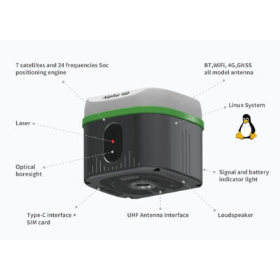
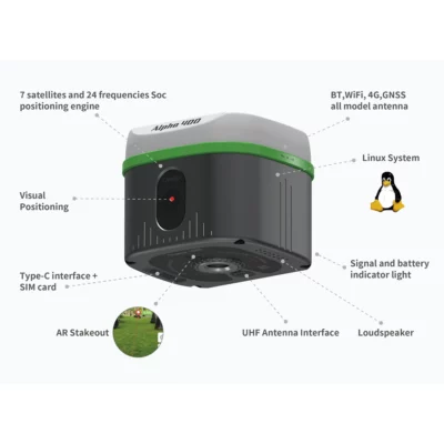
Modern GNSS rover-base systems can include more than basic RTK positioning. IMU tilt compensation allows the rover to measure points without keeping the pole perfectly level, which can save time near walls, fences, trenches and other obstacles. Some systems include cameras, visual stake-out or AR guidance to help users find the correct point more easily in the field. Laser GNSS receivers can measure points that are difficult or unsafe to reach directly with a survey pole. For larger or more complex projects, radio performance is also important. Many rover-base systems include internal UHF radios, while external radios can be used when more range or stronger transmission is needed.
UHF Radio, External Radio or Internet Corrections?
Many rover-base sets use UHF radio to send correction data from the base to the rover. This is practical for local survey sites where the rover stays within radio range of the base station. An external radio can be useful when you need a stronger signal, longer range or better performance across difficult terrain. Radio range depends on output power, antenna setup, terrain, obstacles, local interference and regulations. Some systems can also use internet-based correction transfer. This can be useful when radio communication is not practical, but it depends on stable internet access at the base and rover.
What Determines the Price of a Rover-Base Set?
The price of a GPS rover-base set depends on the receivers, supported satellite constellations, number of frequencies, RTK performance, IMU quality, radio power, internet options, controller, software, accessories and overall ruggedness. Entry-level rover-base sets are suitable for standard surveying, stake-out and mapping work. More advanced systems may include stronger IMU tilt compensation, better radio performance, camera stake-out, laser measurement, higher-end field software or more rugged hardware for difficult environments.
Which GPS Rover-Base Set Should I Choose?
The best rover-base set depends on your work environment and correction needs. For open construction sites and general surveying, a reliable dual-receiver RTK GNSS set with IMU tilt compensation is often a good choice. For remote areas or larger sites, radio performance becomes more important. For construction layout, visual stake-out or AR guidance can make the workflow easier. For hard-to-reach points, a laser GNSS rover-base set may be more efficient. For projects where GNSS conditions are difficult, consider whether a GNSS system with LiDAR, SLAM or additional scanning capabilities is more suitable. If you are unsure which rover-base system fits your project, compare the GPS rover-base sets above or contact Global GPS Systems for advice based on your country, correction method, working distance, software preference and required accuracy.