


 GPS & GNSS
 Lidar scanning
 Total Station
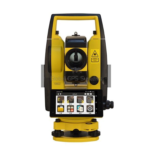
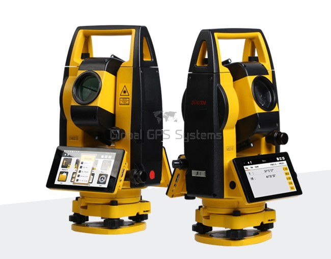
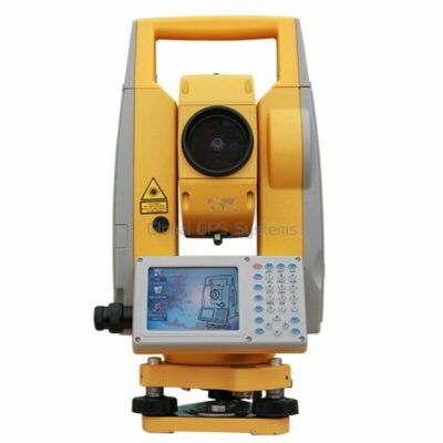
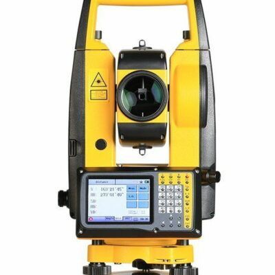
South A1 Android Total Station
Get the best price for your setup
Contact our experts for the best possible price and configuration.
- Fast response
- Expert configuration advice
- No overpaying for features you do not need
The South A1 Android Total Station is a manual surveying instrument for accurate angle, distance, layout, and site measurement work. Available with 1″ or 2″ angular accuracy, it measures up to 5,000 m with a prism and up to 1,000 m without a reflector. Its Android 9 interface, 5-inch touchscreen, graphical stake-out guidance, automatic graphic drawing, and built-in toolbar help surveyors and construction crews work efficiently in the field. Bluetooth, Wi-Fi, 4G, USB, and RS-232 connectivity support flexible data transfer and integration with field software. It is suitable for topographic surveys, construction layout, engineering measurements, GIS fieldwork, and use alongside GNSS equipment.
South A1 Android Total Station Highlights
| Angular Accuracy | 1″ or 2″ models |
|---|---|
| Prism Measurement Range | Up to 5,000 m |
| Reflectorless Range | Up to 1,000 m |
| Operating System | Android 9.0 |
| Display and Battery | 5-inch touchscreen; up to 8 hours |
Valued customers:










Find RTK Networks
Search NTRIP providers and connect to reliable RTK correction services.
Description
South A1 Android Total Station for Surveying and Construction
The South A1 is a manual Android total station designed for surveyors, construction teams, engineers, GIS professionals, and field crews who need dependable angle, distance, coordinate, and stakeout measurements from one instrument. It combines a conventional precision total station with an Android-based onboard platform, a color touchscreen, wireless communication, graphic field guidance, and practical survey functions that help reduce the amount of equipment and manual data handling required on site.
Unlike an RTK GNSS receiver, the South A1 does not depend on satellite visibility or a correction network to measure points. It works by observing angles and distances to a prism, reflector sheet, or suitable surface. This makes it useful around buildings, under trees, beside structures, in tunnels, and in other locations where GNSS signals may be obstructed or unreliable. Many surveying and construction teams use a total station alongside RTK GNSS equipment so they can choose the best measurement method for each part of a project.
Practical field measurement with the South A1
The South A1 is built for controlled, repeatable field measurements. Its electronic angle measurement system is available in 1-second and 2-second accuracy models, allowing buyers to select a configuration that matches the precision requirements of their work. The 1-inch version is suited to applications where tighter angular control is important, while the 2-inch version can be a practical choice for general construction layout, topographic surveying, utility work, and routine engineering measurements.
For distance measurement, the instrument can measure up to 5,000 meters to a single prism under suitable conditions. It also provides reflectorless measurement up to 1,000 meters, although the usable range depends on the target surface, lighting, atmospheric conditions, instrument setup, and the angle of incidence. Reflectorless measurement is especially useful when a prism cannot be placed safely or when the point is located on a wall, façade, pavement, rock face, stockpile, or other accessible surface.
When higher confidence is needed, prism-based measurement remains the preferred method for many control, boundary, and construction layout tasks. Reflectorless measurement is convenient for inaccessible points and quick checks, while prism observations are often better suited to long-range work and critical points where the target can be occupied directly.
Android touchscreen workflow
A key feature of the South A1 is its Android operating system and integrated field interface. The 5-inch capacitive touchscreen provides a more familiar way to navigate measurement screens, enter values, review points, and access survey programs. Multi-touch operation makes it easier to move through menus and view graphical information than with a traditional button-only instrument.
The Android platform also provides an open interface for compatible third-party software and customized applications. This can be useful for organizations that already use a particular field data-collection workflow or need to connect the total station with specialized software. The onboard system is supported by internal storage and processing hardware designed to handle field calculations, point records, drawings, and project data without requiring a separate data collector for every task.
In practical use, the touchscreen and onboard software help the operator complete more of the workflow directly at the instrument. Measurements can be reviewed while the crew is still on site, reducing the need to wait until the data is transferred to an office computer before checking whether a point or layout operation was completed correctly.
Stakeout and construction layout
The South A1 is well suited to construction stakeout and setting-out work. The instrument can guide the operator toward design points and provide graphical information that makes it easier to understand the direction and distance to the required location. A compass pointer and stakeout sketch help the user move the prism or target into position while working through building corners, grid lines, foundation points, anchor locations, columns, roads, drainage features, and other construction elements.
For construction crews, this means the surveyor can establish points from project coordinates and guide the rod person without relying only on written offsets or verbal instructions. The graphical workflow is useful when setting out multiple points in sequence, checking whether a point has been placed correctly, or returning to a project after a break without having to reconstruct the entire procedure from memory.
The instrument also includes quick-access controls for commonly used functions such as measurement modes, target settings, the laser pointer, and the plummet. These controls are intended to reduce unnecessary menu navigation during busy field operations, particularly when the operator is switching between prism, reflectorless, tracking, and fine measurement tasks.
Survey functions for everyday fieldwork
The South A1 can support a broad range of routine total station operations, including angle and distance measurement, coordinate collection, station setup, backsight orientation, resection, stakeout, remote elevation measurements, missing-line measurements, offsets, area calculations, and other coordinate geometry tasks. These functions make the instrument suitable for both basic layout work and more structured surveying workflows.
For topographic and as-built surveys, the operator can collect points with codes and coordinate information, then review the work on the integrated graphical display. This can help identify gaps in coverage, duplicated points, or unexpected measurements before leaving the site. For road, utility, and civil projects, the instrument can be used to observe alignment features, collect detail points, measure offsets, and check the position of installed work against the design.
Resection and other station-establishment methods can be helpful when the instrument cannot be set directly over a known control point. Offset functions are useful when a feature cannot be occupied directly, such as the edge of a wall, a roadside obstacle, a buried utility reference, or a point located behind a barrier. The exact workflow should always be selected according to the project control method and the accuracy required.
Automatic correction and measurement stability
The South A1 uses a dual-axis compensator to help account for small changes in the instrument’s level during operation. The compensator works within its specified range, but it does not replace careful setup. A stable tripod, properly centered instrument, accurate leveling, and sensible observation procedures remain essential for reliable results.
Atmospheric correction and prism-constant settings can be applied so that measured distances better reflect the conditions and target being used. Temperature and pressure can influence electronic distance measurement, particularly over longer ranges, so field crews should use appropriate environmental values when project accuracy requires it. The instrument also provides a fast measurement response for tracking and continuous work, while fine measurement mode can be used when the operator needs a more deliberate observation.
The 30x telescope provides a clear, upright view for aiming at prisms and visible targets. Its design is suitable for general building, infrastructure, land, and engineering surveys, with the practical benefit of allowing the operator to identify the target through the telescope before taking the measurement. For critical work, target centering and sighting technique should be checked carefully rather than relying only on the nominal telescope magnification.
Data transfer and field connectivity
Field data can be transferred using Bluetooth, Wi-Fi, USB, RS-232C, or compatible flash storage. This gives survey teams several options for moving job files between the instrument, a computer, a tablet, or another field device. Wireless connectivity can reduce cable handling around the tripod, while USB and serial communication remain useful when a project requires a direct or more controlled connection.
The Android platform also supports network connectivity through Wi-Fi, hotspot functions, and available mobile communication configurations. These features can help with file exchange, software connectivity, remote workflows, or communication with compatible applications. Actual network availability depends on the SIM configuration, local cellular coverage, software compatibility, and the requirements of the field system being used.
For organizations with established CAD, GIS, or survey-office procedures, the important consideration is not only how the instrument measures but also how easily the resulting files can be incorporated into the rest of the workflow. Before purchasing, buyers should confirm the required file formats, field software, coordinate systems, coding standards, and office software compatibility for their specific projects.
Designed for demanding job sites
The South A1 has an IP55 environmental protection rating, providing protection against dust ingress and water jets from limited directions. This rating is suitable for normal outdoor surveying and construction environments when the instrument is used correctly, protected from unnecessary exposure, and stored in its case when not in operation. It is not a substitute for weather planning, and the instrument should not be immersed or left exposed to heavy rain for extended periods.
The instrument weighs approximately 6 kilograms and measures about 206 by 200 by 353 millimeters. These dimensions place it within the expected handling range for a conventional manual total station while still providing an integrated touchscreen and onboard computing platform. A lithium battery provides approximately eight hours of working time under stated conditions, although actual runtime will vary with temperature, screen use, wireless communication, measurement activity, and battery condition.
The laser plummet helps the operator center the instrument over a ground mark or known point. A laser pointer can also assist with target identification and general aiming. As with any total station, the laser should be used in accordance with applicable safety practices and should never be directed toward people, vehicles, aircraft, or reflective surfaces where it could create a hazard.
Who uses the South A1?
The South A1 is a good fit for professional and practical users who need a manual total station with integrated field computing. Typical users include land surveyors, construction surveyors, civil engineers, building contractors, site supervisors, utility contractors, road and infrastructure crews, mapping technicians, GIS field teams, and technical training institutions.
Construction professionals can use it for establishing site control, setting out foundations, checking structural positions, measuring elevations, verifying installed work, and recording as-built conditions. Surveyors can use it for topographic detail, boundary-related observations, engineering surveys, control work, and point collection. GIS and mapping teams can use the instrument to collect accurate ground-based coordinates in areas where a handheld GPS or RTK receiver cannot provide a clear or dependable solution.
Drone pilots and UAV mapping teams may also find a total station useful as a complementary tool. While a drone can efficiently capture broad areas from above, the South A1 can be used to establish ground control, check individual features, measure vertical or obstructed locations, and verify selected points on the ground. It is not a replacement for an RTK drone workflow, but it can provide an additional measurement method when project conditions call for line-of-sight observations.
South A1 compared with RTK GNSS equipment
The South A1 and an RTK GNSS receiver solve different field measurement problems. RTK GNSS is often the faster choice for open-sky point collection and coordinate work over large areas, particularly when correction services are available. A total station is often more useful when satellite visibility is blocked, when the work is close to tall structures, when vertical and relative layout control is important, or when the operator needs to measure points that can be observed optically but not reached directly.
For many contractors and survey companies, the most flexible setup includes both technologies. GNSS can be used to establish or check control and collect open-area points, while the total station can transfer coordinates into obstructed areas, set out precise construction points, and perform detailed relative measurements around structures. Choosing between the South A1 and an RTK system should therefore be based on the site environment, required accuracy, crew size, project software, correction-service availability, and the type of measurements performed most often.
Why choose the South A1?
- Manual total station operation with Android-based field computing.
- 1-inch and 2-inch angle accuracy configurations for different survey requirements.
- Prism measurement up to 5,000 meters and reflectorless measurement up to 1,000 meters under suitable conditions.
- 5-inch capacitive touchscreen with graphical guidance for field operations.
- Stakeout, coordinate, offset, resection, area, remote measurement, and construction layout functions.
- Bluetooth, Wi-Fi, USB, RS-232C, and flash-storage data transfer options.
- IP55 protection and approximately eight hours of battery operation under stated conditions.
The main advantage of the South A1 is the way it brings measurement, calculation, visualization, and data handling together in one field instrument. It is intended for crews that want more than a basic angle-and-distance device but do not necessarily need a robotic total station. The manual workflow still requires the operator to aim, measure, and communicate with the prism person, but the Android interface and graphical tools can make those tasks easier to organize and review.
Choosing the right configuration
When selecting a South A1, buyers should consider whether the 1-inch or 2-inch angle model better matches their work, whether prism and reflectorless measurements will both be used, what software and file formats are required, and whether wireless communication is part of the planned workflow. It is also important to confirm the included accessories, battery configuration, charger requirements, prism equipment, tripod, tribrach, field software, and any local training or calibration needs before placing an order.
For teams moving from a conventional total station to an Android model, the transition is usually easiest when the field crew has a clear process for project creation, coordinate-system setup, data backup, file naming, and office transfer. Operators should also maintain standard checks for instrument centering, leveling, backsight orientation, prism constant, atmospheric settings, and control-point quality.
Buy the South A1 from Global GPS Systems
Global GPS Systems can help surveyors, contractors, engineers, GIS teams, and other field professionals choose the South A1 configuration that matches their working conditions. The right setup may depend on whether the instrument will be used mainly for construction stakeout, topographic surveying, as-built measurement, utility work, engineering control, or as a complement to RTK GNSS and drone mapping equipment.
For advice on compatibility, field software, accessories, shipping, setup, or support, contact Global GPS Systems before ordering. Their product specialists can help compare the available South A1 options and identify the equipment needed to use the total station effectively on real job sites.
Specifications
South A1 Specifications
Product Overview
| Brand | SOUTH |
|---|---|
| Product series | A1 Android Total Station |
| Instrument type | Manual total station with integrated Android operating system |
| Available models | A1 1", A1 2", A1X 1" and A1X 2", depending on configuration |
| Primary measurement functions | Horizontal angle, vertical angle, slope distance, horizontal distance, elevation difference, coordinate measurement and stakeout |
| Typical users | Land surveyors, construction surveyors, civil engineers, geomatics professionals, site engineers, contractors, survey technicians and surveying students |
| Typical industries | Land surveying, topographic mapping, construction, civil engineering, road and highway construction, tunnel engineering, utility layout, cadastral work, education and infrastructure development |
Angle Measurement
| Specification | A1 1" | A1 2" |
|---|---|---|
| Detection method | Absolute encoding | Absolute encoding |
| Encoding disk diameter | 79 mm | 79 mm |
| Minimum reading | 0.1" | 1" |
| Angle accuracy | 1" | 2" |
| Available angle units | Degree, gon and mil | Degree, gon and mil |
Distance Measurement
| Measurement mode | Range | Accuracy / measurement time |
|---|---|---|
| Single prism | Up to 5,000 m | A1 1": ±(1 + 1 × 10⁻⁶ × D) mm; A1 2": ±(2 + 2 × 10⁻⁶ × D) mm |
| Triple prism | Up to 1,000 m | Same model-dependent prism accuracy specification |
| Reflective sheet | Up to 1,000 m | Same model-dependent distance accuracy specification |
| Reflectorless measurement | Up to 1,000 m using a Kodak standard gray target with 90% diffuse reflectance | 3 + 2 ppm from 0 to 300 m; 5 + 2 ppm from 300 to 600 m; 10 + 2 ppm above 600 m |
| Fine measurement time | Approximately 0.3 seconds | |
| Tracking measurement time | Approximately 0.2 seconds | |
| Normal measurement time | Approximately 0.2 seconds | |
| Distance units | Meters and feet | |
| Prism constant | Automatic correction | |
| Atmospheric correction | Automatic temperature and pressure sensor correction | |
Telescope
| Telescope image | Erect |
|---|---|
| Magnification | 30× |
| Tube length | Approximately 154 mm; some earlier A1 documentation lists 152 mm |
| Effective aperture | 45 mm |
| DTM aperture | 50 mm; some earlier A1 documentation lists 47 mm |
| Field of view | 1°30′ |
| Resolving power | 3" |
| Minimum focusing distance | 1.5 m |
Compensation, Leveling and Plummet
| Compensator type | Dual-axis liquid-electric sensor |
|---|---|
| Compensator range | ±6′ on current A1-series specifications; some earlier A1 documentation lists ±3′ |
| Compensator accuracy | 1" |
| Plate vial | 30″/2 mm |
| Circular vial | 8′/2 mm |
| Standard plummet | Class II red laser plummet on A1 models |
| Optional plummet | Optical plummet may be available depending on configuration |
| Auto height measurement | Available on compatible A1X configurations; automatic instrument-height measurement is performed through the integrated bottom laser system |
| Auto height measuring range | 0.6–2.0 m on compatible A1X configurations |
| Auto height minimum reading | 1 mm on compatible A1X configurations |
| Auto height accuracy | 3 mm on compatible A1X configurations |
| Auto height deviation | 0.4 mm at 1.5 m instrument height on compatible A1X configurations |
| Auto height laser spot diameter | 1.5 mm at 1.5 m instrument height on compatible A1X configurations |
Guide Light and Stakeout Assistance
| Feature | A1 configuration | A1X configuration |
|---|---|---|
| Guide light | Not generally specified | Red and yellow flashing LED guide light |
| Guide-light working range | Not specified | Up to approximately 150 m on current specifications; some A1X literature states up to 200 m |
| Stakeout guidance | Compass pointer and stakeout sketch supported through onboard software | Compass pointer, stakeout sketch and guide-light assistance |
Display, Operating System and Processing
| Operating system | Android 9 or Android 9.0 on current A1-series documentation |
|---|---|
| Display type | Graphical LCD touchscreen |
| Display size | 5.0 inches |
| Touchscreen | Capacitive multi-touch screen |
| Display resolution | 1,280 × 720 pixels on A1X documentation |
| Processor | MSM8953, 8-core 64-bit processor at 1.8 GHz on the current A1 listing; earlier A1 documentation lists an MT6735 4-core processor at 1.3 GHz |
| RAM | 3 GB |
| Internal storage | 32 GB ROM |
| Graphic distance display | Maximum 99,999,999.999; minimum 0.1 mm for 1″ models and 1 mm for 2″ models |
| Third-party software support | Open Android interface designed to support compatible third-party surveying applications |
Onboard Surveying Functions
| Point collection | Supported |
|---|---|
| Point stakeout | Supported |
| Resection | Supported |
| Reference line | Supported |
| Line stakeout | Supported |
| Distance offset | Supported |
| REM measurement | Supported |
| MLM measurement | Supported |
| Road design | Supported on compatible onboard software configurations |
| Road stakeout | Supported on compatible onboard software configurations |
| Area and perimeter calculation | Supported |
| Distance and angle conversion | Supported |
| Calculator | Built-in |
| Automatic graphic drawing | Real-time graphical display of measured data and survey geometry |
| Voice recording | Available |
| GPS function | Available on specified configurations |
Data Transfer and Connectivity
| Serial interface | RS-232C |
|---|---|
| USB connectivity | USB interface; mini-USB or USB configuration may vary by model revision |
| Bluetooth | Built-in wireless Bluetooth |
| Wi-Fi | Built-in Wi-Fi |
| Wi-Fi hotspot | Supported |
| Mobile network | 4G available on specified configurations |
| Legacy mobile network support | 3G and 2G available on specified configurations |
| Data storage and transfer | Internal flash storage, USB, RS-232C and wireless transfer |
Power Supply
| Battery type | Rechargeable lithium battery |
|---|---|
| Battery capacity | 5,000 mAh on current A1-series specifications |
| Battery voltage | 7.4 V DC |
| Typical operating time | Approximately 10 hours on current A1-series specifications; earlier A1 documentation lists approximately 8 hours |
| Measurement trigger | Trigger button located under the battery housing |
Environmental and Physical Specifications
| Ingress protection rating | IP55 |
|---|---|
| Operating temperature | -20°C to +50°C according to earlier A1 technical documentation |
| Dimensions | Approximately 206 × 200 × 353 mm |
| Weight | Approximately 6 kg |
| Laser classification | Class II red laser for the laser plummet; observe applicable laser-safety requirements |
| Leveling reference | Electronic dual-axis compensation with plate and circular vial leveling |
Package and Included Items
| Item | Quantity | Notes |
|---|---|---|
| SOUTH A1 total station | 1 | Exact angular-accuracy model depends on the selected configuration |
| Rechargeable lithium battery | Configuration dependent | Battery capacity and quantity should be confirmed before ordering |
| Battery charger and power accessories | Configuration dependent | Included accessories may vary by region and package |
| Instrument case | Configuration dependent | Confirm package contents with the supplier |
| Data and communication cables | Configuration dependent | USB and serial accessories may vary by model revision |
| Optional optical plummet, guide light or auto-height accessories | Optional | Availability depends on whether the selected unit is an A1 or A1X configuration |
Specifications and package contents may vary by configuration, region or manufacturer update. Always check the current configuration before ordering.
Reviews (1)
1 review for South A1 Android Total Station
Only logged in customers who have purchased this product may leave a review.
FAQ
South A1 FAQ
Product Overview and Applications
What is the South A1 Android Total Station?
The South A1 Android is a manual total station for measuring horizontal angles, vertical angles, distances and coordinates. It combines electronic surveying functions with an Android-based touchscreen interface, onboard data collection, stake-out tools and wireless connectivity.
Is the South A1 a manual or robotic total station?
The South A1 is a manual total station. The operator manually points and focuses the telescope on the target. It does not provide the automatic target tracking or remote robotic operation available on a robotic total station.
Who uses the South A1 Android Total Station?
The South A1 is designed for land surveyors, construction surveyors, civil engineers, site engineers, road and infrastructure contractors, utility contractors and other professionals who need accurate field measurements and construction layout.
Which industries use this total station?
Typical applications include land surveying, building construction, civil engineering, road construction, infrastructure development, site preparation, topographic surveying, utility work, earthworks and general engineering surveys.
What surveying tasks can the South A1 perform?
The instrument supports angle measurement, distance measurement, coordinate measurement, point collection, resection, backsight checking, offsets, remote elevation measurement, area and volume calculations, road alignment work and stake-out operations.
Is the South A1 suitable for construction layout?
Yes. Its point, line, alignment and road stake-out functions are designed to help construction teams position foundations, columns, walls, roads, utilities and other designed points accurately on site.
Measurement Performance and Optical Functions
What is the maximum distance measurement range?
The South A1 datasheet lists a reflector-prism measurement range of up to 5,000 metres and a reflectorless measurement range of up to 1,000 metres under specified conditions. Actual range depends on the target, atmospheric conditions, visibility, prism type and measurement mode.
Can the South A1 measure without a prism?
Yes. The South A1 supports reflectorless measurement for suitable surfaces. Reflectorless range and accuracy vary depending on the surface material, colour, angle of incidence, weather and distance to the target.
What angle accuracy options are available?
The A1 datasheet identifies 1-second and 2-second versions. The appropriate version depends on the required survey accuracy and the configuration supplied. Confirm the selected angle-accuracy specification before ordering.
What is the telescope magnification?
The South A1 telescope provides 30x magnification, with an erect image, a 1°30′ field of view and a minimum focusing distance of approximately 1.5 metres.
Does the South A1 have a laser plummet?
Yes. The instrument includes a laser plummet for centering over the survey point. An optical plummet is listed as an optional alternative in the product specifications.
Does the instrument have tilt compensation?
Yes. The South A1 uses a dual-axis electronic compensator. The datasheet lists a working range of approximately ±3 arc minutes and supports automatic correction of small instrument-tilt errors when the compensator is enabled.
Software, Data Collection and Connectivity
What operating system does the South A1 use?
The South A1 product information and datasheet identify Android 9.0 as the system version. Because hardware and software revisions can vary, confirm the current supplied configuration if a specific application or Android compatibility requirement is important.
Does the South A1 have a touchscreen?
Yes. It features a 5-inch capacitive touchscreen with multi-touch operation and a graphic user interface for measurement, data collection, stake-out and instrument settings.
What software functions are included?
Functions documented for the A1 include coordinate measurement, known-point station setup, station-height calculation, resection, point-to-line calculations, offsets, minimum-line measurement, remote elevation measurement, point and line stake-out, alignment stake-out, traverse, inverse calculations, area, perimeter, intersections, volume and road alignment tools.
Can the South A1 collect and store survey data?
Yes. The instrument stores raw observations, coordinate data, point codes and graphic data. The documented storage configuration includes 32GB ROM and 3GB RAM.
Can data be imported and exported?
Yes. The A1 user manual includes data import and export functions and supports multiple data-transfer methods. The available file formats and compatibility should be checked against the CAD, surveying or construction software used by your team.
What connectivity options are available?
The South A1 supports Bluetooth, Wi-Fi, Wi-Fi hotspot, USB and RS-232C connections. The datasheet also identifies 3G/2G and 4G support for compatible configurations and networks.
Can third-party Android surveying software be installed?
The product documentation describes an open Android interface that can support third-party software. Compatibility depends on the application, Android version, required drivers, licensing and the specific instrument configuration. Confirm software support before deployment.
Does the South A1 provide graphical stake-out guidance?
Yes. The product information describes compass-pointer guidance and stake-out sketches. The user manual also documents point, angle-and-distance, alignment and line stake-out workflows.
Setup, Durability and Ownership
How is the South A1 set up on a job site?
Mount the instrument on a stable tripod, center it over the station point using the laser plummet, level it with the circular and plate vials, enable the compensator if required, set the instrument height and establish the station and backsight before measuring or staking out points.
What battery life can I expect?
The datasheet lists approximately 8 hours of working time. Actual battery life depends on temperature, measurement mode, wireless communication, screen use, charging condition and the age of the battery. Carrying a charged spare battery is recommended for full-day fieldwork.
What is the ingress protection rating?
The South A1 is rated IP55 according to the product datasheet. This indicates protection against dust ingress that could interfere with operation and water jets from any direction. It should still be protected from prolonged rain, immersion and improper storage.
How much does the South A1 weigh?
The datasheet lists the instrument weight as approximately 6.0 kilograms and the dimensions as approximately 206 × 200 × 353 millimetres. Confirm the shipping and complete-kit weight if accessories and the carrying case are included.
What accessories are needed to use the South A1?
Typical field equipment includes a stable surveying tripod, tribrach, prism and prism pole for prism measurements, survey markers, a measuring tape for instrument and target heights, spare batteries and suitable data-transfer accessories. The exact kit contents depend on the selected configuration.
How should the South A1 be maintained?
Keep the instrument in its carrying case when it is not in use, protect it from dust and humidity, clean optical surfaces only with suitable lens-cleaning materials, dry the instrument before powering it on and avoid exposing the telescope directly to the sun without an appropriate filter.
How should the battery be stored when the instrument is not used?
For extended storage, remove the battery from the instrument and store it separately in suitable conditions. The user manual recommends charging the battery at least once a month during long-term storage and using the official charger supplied or approved for the battery.
Does the South A1 require calibration?
Yes. Like all total stations, the South A1 should be checked and calibrated at suitable intervals and after impacts, transport damage or unusual measurement results. Checks may include the plate vial, compensator, collimation, vertical index, EDM constant, laser plummet and tribrach condition.

 GPS & GNSS
 Total Stations
 Data collectors
 Software
 Correction services
 Machine control
 External radio
 Marine
 Accessories
Alfio pacifici (verified owner) –
Very good instrument