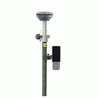
RTK GPS Receivers
Compare professional GPS and GNSS receivers for land surveying, mapping, construction layout, drone surveying and geospatial data collection. Choose from RTK rover sets, rover-base sets, handheld GPS devices, reference station equipment, GNSS antennas and OEM boards. Modern GNSS receivers can use GPS, Galileo, GLONASS and BeiDou satellites for accurate positioning. Many systems also support RTK accuracy, IMU tilt compensation, visual stake-out, laser measurement, LiDAR or SLAM workflows.
Global GPS Systems
4.73 store rating (567 reviews) | 4.68 product rating
Best GPS System for Land Surveying
The best GPS system for a land surveyor depends on the type of work you need to do, the accuracy you require and the correction services available in your area. A construction worker who needs simple point collection and stake-out software may not need the same system as a professional land surveyor working on complex boundary, road or infrastructure projects. For drone surveying, a reliable RTK GNSS receiver can be used to place Ground Control Points, or GCPs, before an aerial survey. For construction layout, utility mapping and general field data collection, a rover set with easy-to-use survey software is often the most practical choice. For more demanding survey work, it is worth looking at receivers with stronger RTK performance, IMU tilt compensation, visual stake-out, laser measurement or LiDAR integration.
What Determines the RTK GPS Price?
The price of an RTK GPS or GNSS receiver is influenced by the receiver hardware, GNSS board, number of supported frequencies, satellite constellation support, RTK performance, IMU quality, radio options, internet connectivity, software compatibility and included accessories. Basic GPS receivers may only use GPS signals on a limited number of frequencies. Professional GNSS receivers can use multiple satellite constellations, such as GPS, Galileo, GLONASS and BeiDou. More advanced RTK receivers can process multiple frequencies and use real-time correction data to calculate centimetre-level positions. Modern systems may also include features such as tilt compensation, integrated radios, 4G connectivity, cameras, AR stake-out, laser measurement or LiDAR. These features can increase the price, but they can also save a lot of time in the field.
What is the Difference Between a GNSS Receiver and a GPS Receiver?
Many people still use the term GPS receiver, but most professional survey receivers today are GNSS receivers. GPS is one satellite constellation. GNSS stands for Global Navigation Satellite System and refers to the wider group of positioning satellite systems. A GPS-only receiver uses signals from the GPS constellation. A GNSS receiver can use signals from multiple constellations, including GPS, Galileo, GLONASS, BeiDou, QZSS and NavIC, depending on the receiver. Using more constellations can improve satellite availability, reliability and performance, especially in areas with trees, buildings or other obstacles.
Single-Frequency GPS vs Dual-Frequency and Multi-Frequency GNSS
The number of frequencies a receiver can process has a direct impact on performance and reliability. A single-frequency GPS receiver is usually suitable for basic positioning, but it is not the best choice for professional RTK surveying. Dual-frequency and multi-frequency GNSS receivers can use more signals from more satellites. This helps the receiver calculate a more stable and accurate position, especially when working with RTK corrections. Common satellite signals include GPS L1, L2 and L5, Galileo E1, E5 and E6, GLONASS L1, L2 and L3, and BeiDou B1, B2 and B3. For land surveying, construction layout and other professional survey work, a dual-frequency or multi-frequency RTK GNSS receiver is usually recommended.
Which RTK System is Best for Me?
The best RTK system depends on your application. For standard surveying tasks such as collecting points, staking out building sites, measuring terrain or recording utilities, a reliable RTK GNSS rover with good field software is often enough. For faster fieldwork, an IMU tilt receiver can help you measure points without keeping the pole perfectly level. For construction stake-out, a receiver with visual guidance or AR stake-out can make it easier to find the correct position. For difficult or unsafe points, a laser GNSS receiver can help measure locations without placing the pole directly on the point. For scanning, point clouds or complex environments, a GNSS receiver with LiDAR or SLAM technology may be the better choice. The field software is also important. Good survey software allows you to import and export files such as DXF, CSV, TXT, SHP or LandXML, so you can move data between the field, CAD software, GIS software and office workflows.
GPS Satellite Only or Full GNSS Constellation?
GPS is the best-known satellite positioning system, but professional GNSS receivers usually use more than GPS alone. A receiver that supports GPS, Galileo, GLONASS and BeiDou can use more satellites, which helps improve availability and performance in the field. This is especially useful when working near buildings, trees, machinery, slopes or other obstructions. More satellites do not automatically guarantee perfect accuracy, but they give the receiver more data to work with and can improve RTK reliability.
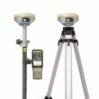
When Do I Need a Rover Only or a Rover and Base Station?
Whether you need a rover-only setup or a rover and base station setup usually depends on RTK network coverage in your working area. A rover-only setup is often the best choice when you have access to a reliable RTK network, VRS network, CORS network or NTRIP correction service. In this setup, one GNSS receiver is used as the rover and receives correction data through the internet. A rover and base setup is better when there is no reliable RTK network available, when mobile internet is limited, or when you want to work independently from external correction services. In this setup, one receiver is placed on a fixed location as the base station and sends correction data to the rover.
Choosing the Right GPS or GNSS Receiver
The right system depends on your work, accuracy needs, software preference, country and correction network. For basic GIS mapping, a handheld GPS device may be enough. For centimetre-level surveying, construction layout and stake-out, an RTK GNSS rover set is usually the better option. For remote projects, a rover-base set may be required. For permanent correction infrastructure, a GNSS reference station can be used. If you are unsure which GPS or GNSS receiver fits your work, compare the categories and products above or contact Global GPS Systems for advice based on your project, location and required accuracy.