

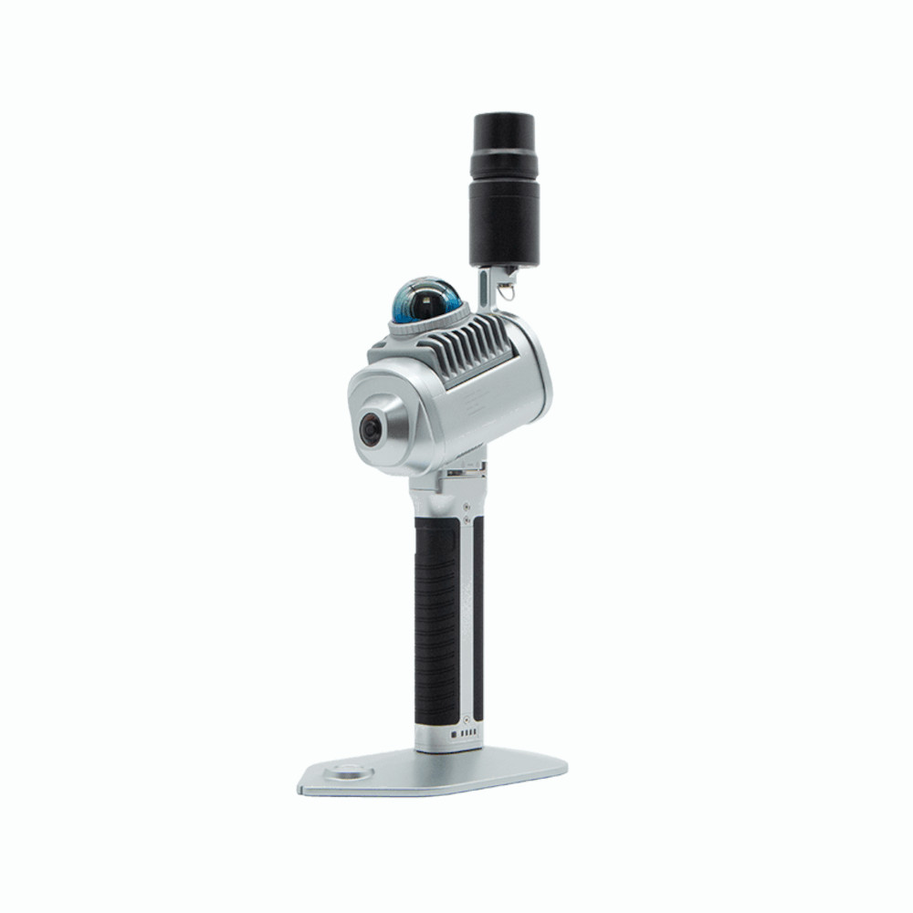
Greenvalley LiGrip 01 Lite
This product is available
Get the best price for your setup
Contact our experts for the best possible price and configuration.
The LiGrip O1 Lite is the newest addition to GreenValley’s lightweight handheld LiGrip series, designed with an integrated structure. It supports multiple mapping methods, including RTK-SLAM, PPK-SLAM, and SLAM, allowing for real-time output of high-precision LAS point cloud data in true color, complete with absolute coordinates. The device can also be paired with an RTK module and telescopic pole, making it ideal for tasks like floor plan creation, mine and stockpile surveys, as well as facade measurements. When used in conjunction with LiDAR360 and LiDAR360MLS software, it delivers an efficient, all-in-one solution for customers.
Valued customers:


Find RTK Networks
Search NTRIP providers and connect to reliable RTK correction services.
Description
LiGrip O1 Lite: Advanced, Lightweight Handheld LiDAR Solution
The LiGrip O1 Lite is a powerful, compact LiDAR solution, representing the latest generation of GreenValley’s lightweight handheld products. It is designed for professionals who require accuracy, versatility, and ease of use in a variety of mapping and surveying tasks. This cutting-edge device provides seamless integration with multiple software platforms, offering a turnkey solution for all your surveying and mapping needs.
Key Features and Integrated Design
The LiGrip O1 Lite boasts an integrated, lightweight design, making it highly portable and user-friendly. Despite its compact form, it doesn’t compromise on performance. Equipped with advanced features such as RTK-SLAM, PPK-SLAM, and SLAM support, it allows users to choose the most appropriate mapping method depending on their environment and requirements. The device outputs high-precision, true-color LAS point cloud data in real-time, complete with absolute coordinates for accurate measurements.
Additionally, the LiGrip O1 Lite is designed to be flexible and adaptable. It can be paired with an RTK module for enhanced accuracy, and the option to mount it on a telescopic pole expands its range of applications.
Wide Range of Applications
The versatility of the LiGrip O1 Lite makes it ideal for a broad spectrum of industries. Some of the key applications include:
- Floor Plan Measurement: Accurately map interior layouts, providing detailed and reliable data for architectural designs.
- Mine Surveying: Safely and efficiently gather data in mining environments, even in difficult-to-reach areas.
- Stockpile Measurement: Quickly assess stockpile volumes with high precision, helping streamline inventory management.
- Facade Measurement: Capture detailed measurements of building exteriors for restoration, design, or inspection purposes.
Whether working in construction, urban planning, mining, or industrial environments, the LiGrip O1 Lite provides the tools necessary for precise and efficient data collection.
Seamless Integration with LiDAR360 and LiDAR360MLS Software
To further enhance its capabilities, the LiGrip O1 Lite integrates smoothly with GreenValley’s LiDAR360 and LiDAR360MLS software packages. This combination delivers a full turnkey solution that simplifies data processing, visualization, and analysis, helping users streamline their workflow. The software platforms support a range of functionalities from data management to advanced analytics, allowing professionals to maximize the potential of their collected data.
In conclusion, the LiGrip O1 Lite is a highly efficient, user-friendly, and versatile tool designed for those in need of reliable LiDAR solutions. Its robust features, combined with powerful software integration, make it the ideal choice for professionals looking for high-precision, real-time mapping solutions across various industries.
Datasheets & Manuals
Datasheets and manuals
Datasheet
Quick Start Guide
Reviews (0)
Only logged in customers who have purchased this product may leave a review.
Reviews
There are no reviews yet