

GNSS
What is RTK and what does it stand for?
If you work in surveying, construction, agriculture, GIS mapping, or drone surveying, you have probably heard the term RTK many times. RTK technology has become the industry standard for professionals who need highly accurate positioning and reliable GNSS measurements in real time. But what exactly is RTK, how does it work, and why is it so important for modern GNSS systems?
RTK stands for Real-Time Kinematic, a satellite positioning technique that dramatically improves the accuracy of standard GPS and GNSS receivers. While traditional GPS positioning is usually accurate within a few meters, RTK technology can reduce positioning errors to just 1–2 centimeters. This level of precision is essential for applications such as land surveying, machine control, precision agriculture, construction layout, and drone mapping, where even small measurement errors can create major problems.
What Does RTK Mean?
The term “Real-Time Kinematic” refers to the process of calculating highly accurate positions in real time while the receiver is moving. Unlike standard GPS systems that rely only on satellite signals, RTK systems continuously receive correction data from a reference station or RTK network. The “real-time” part means corrections are applied instantly while measurements are being collected. The “kinematic” part refers to the fact that the receiver can move while maintaining accurate positioning.
RTK technology was originally associated mainly with GPS satellites, which is why many people still say “RTK GPS.” However, modern RTK systems actually use multiple satellite constellations including GPS, GLONASS, Galileo, and BeiDou. Because of this, the more technically correct term today is often RTK GNSS.
Why Standard GPS Is Not Accurate Enough
Traditional GPS receivers determine position by calculating the travel time of signals sent from satellites orbiting the Earth. While this works well for navigation, several factors reduce positioning accuracy.
Satellite signals are affected by atmospheric disturbances, satellite orbit errors, timing inaccuracies, and signal reflections from buildings or nearby objects. These errors can easily result in positioning deviations of several meters. For smartphone navigation or vehicle routing, this level of accuracy is acceptable. But for professional applications such as surveying property boundaries or guiding construction machinery, meter-level errors are simply too large. RTK solves this problem by correcting satellite signal errors in real time.
How RTK Works
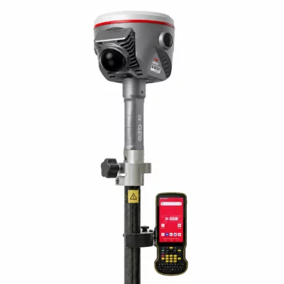
An RTK GNSS system usually consists of two main components: a base station and a rover receiver. The base station is placed at a fixed location with known coordinates. Since its exact position is already known, it can compare the satellite-derived position with its actual position and calculate the errors affecting the GNSS signals.
These correction values are then transmitted to the rover receiver through radio communication, mobile internet, or an NTRIP correction service. The rover applies the corrections immediately, allowing it to calculate a highly accurate position in real time. Modern RTK receivers use carrier-phase measurements rather than relying only on standard satellite timing data. This is one of the main reasons RTK can achieve centimeter-level accuracy.
RTK Accuracy Explained
One of the biggest advantages of RTK technology is its exceptional precision. Standard GNSS positioning is generally accurate within 3 to 10 meters, while RTK systems can achieve accuracy levels of approximately 1 to 2 centimeters under good conditions. This makes RTK suitable for applications where precise measurements are critical.
Surveyors use RTK to measure boundaries and topographic features. Construction companies rely on RTK for machine control and site layout. Farmers use RTK-guided tractors for precision planting and automated steering. Drone operators depend on RTK positioning for highly accurate aerial mapping. Without RTK corrections, these applications would be far less efficient and much less reliable.

RTK GPS vs GNSS
Many people use the terms GPS and GNSS interchangeably, but they are not exactly the same thing. GPS refers specifically to the American satellite navigation system operated by the United States. GNSS, or Global Navigation Satellite System, is the broader term that includes all satellite constellations worldwide. Modern RTK receivers typically track signals from:
- GPS (United States)
- GLONASS (Russia)
- Galileo (Europe)
- BeiDou (China)
Using multiple constellations improves satellite coverage, positioning stability, and overall performance, especially in difficult environments. This is why modern systems are more accurately called RTK GNSS receivers rather than simply RTK GPS systems.
What Is an RTK Base Station?
The RTK base station is one of the most important components in an RTK system. It continuously receives satellite signals and calculates correction data based on its known location. The corrections are then transmitted to nearby rover receivers. Some users operate their own local base station, while others connect to existing RTK correction networks through mobile internet.
Today, many professionals use NTRIP services that provide RTK corrections through permanent reference station networks. This eliminates the need to carry and configure a separate base station in the field. Network RTK solutions have made centimeter-level GNSS positioning more accessible and easier to use than ever before.
Applications of RTK Technology
RTK GNSS technology is used across many industries that require accurate positioning. In land surveying, RTK receivers allow surveyors to measure points quickly and accurately without relying on traditional optical equipment. In construction, RTK machine control systems help operators grade surfaces and position materials precisely according to digital site plans.
Agriculture has also been transformed by RTK positioning. Farmers now use RTK-guided tractors and machinery for precision farming applications such as planting, spraying, and harvesting.
Drone surveying is another rapidly growing RTK application. RTK-enabled UAVs can capture highly accurate aerial data while reducing the need for ground control points.
RTK is also increasingly used in robotics, autonomous vehicles, marine navigation, GIS data collection, and infrastructure inspection.


Lidar & 3D scanning
GPS & GNSS

Lidar & 3D scanning

Lidar & 3D scanning
Advantages of RTK GNSS
The main reason professionals choose RTK is simple: accuracy. RTK positioning dramatically reduces measurement errors while increasing productivity and efficiency. Because corrections are applied in real time, users can work immediately without waiting for post-processing.
Modern RTK receivers are also faster, more reliable, and easier to use than older systems. Multi-frequency GNSS tracking, improved antennas, and advanced correction algorithms have made RTK technology more stable even in challenging environments. As RTK networks continue expanding globally, access to centimeter-level positioning is becoming more affordable for businesses of all sizes.
Limitations of RTK
Although RTK is extremely accurate, it still has some limitations. The system depends on strong satellite visibility and a stable correction signal. Dense forests, urban environments, mountains, and poor mobile coverage can reduce performance.
Distance from the base station also affects accuracy. Single-base RTK systems generally work best within approximately 10 to 20 kilometers from the reference station. Despite these challenges, modern RTK GNSS technology continues improving rapidly and remains the preferred solution for professional high-accuracy positioning.
Conclusion
RTK stands for Real-Time Kinematic, a positioning technology that delivers centimeter-level GNSS accuracy in real time. By combining satellite data with correction signals from a base station or RTK network, RTK systems eliminate many of the errors found in traditional GPS positioning. Today, RTK GNSS technology plays a critical role in surveying, construction, agriculture, drone mapping, machine control, and autonomous navigation. As GNSS technology continues evolving, RTK systems are becoming even more powerful, accessible, and essential for industries that depend on precise positioning.
For professionals who require reliable and accurate GNSS measurements, RTK remains one of the most important positioning technologies available today.