

Carlson SurveyGNSS
This product is Available
Contact our experts for the best possible price and configuration.
Carlson SurveyGNSS post-processing software is a reliable and precise tool for all post-processing applications and is tightly integrated into the Carlson field and office workflow. For surveyors and positioning professionals looking to achieve centimeter accuracy when working on the edge of their RTK infrastructure, perform sub-centimeter positioning, and/or provide the highest quality assurance to their customers, SurveyGNSS is the solution.
Designed for surveyors and positioning professionals, Carlson SurveyGNSS is a simple, yet powerful post-processing software that achieves high accuracy results for computing quality vectors and resultant positions.
Carlson SurveyGNSS Key Features:
- Import GNSS observations from any GNSS receiver in RINEX and other proprietary formats
- Achieve high accuracy results in areas with limited or no real-time corrections
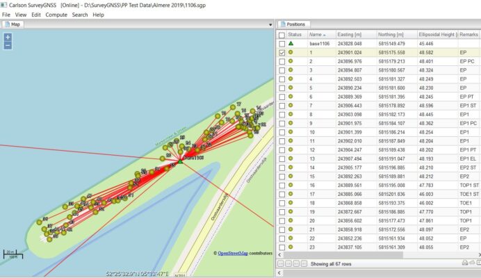
- Get intuitive user interface with tables, maps and graphs
- Interact efficiently with Carlson SurvCE, SurvPC and Carlson office software
- Do quality control of GNSS data before export to Survey or GIS software
You may also like…


Software
Software
Software
Software

Software
Software

Software
Software
Software
Software

Data collection

Software
Valued customers:


Find RTK Networks
Search NTRIP providers and connect to reliable RTK correction services.
Description
CARLSON SURVEYGNSS KEY FEATURES
- Achieve high accuracy results in areas with limited or no real-time corrections

- Process static, kinematic and “stop & go” raw data
- Least squares adjustment including statistical testing
- Optimized for processing data from all 4 “major” constellations (GPS, Glonass, Galileo, BeiDou) from capable GNSS receivers such as the Carlson BRx7
- SurveyGNSS can also process data from the Indian Regional Navigation Satellite System (IRNSS)
- Import GNSS observations from any GNSS receiver in RINEX format
- Accept GNSS observations in a variety of proprietary formats
- An intuitive user interface with tables, maps and graphs
- Improve the quality of single frequency GIS data
- Interact efficiently with Carlson SurvCE, SurvPC and Carlson office software
- Do quality control of GNSS data before export to Survey or GIS software
CARLSON SURVEYGNSS AT A GLANCE
• Supports differential post-processing of RINEX GNSS observations in static, ‘stop and go’ and kinematic positioning modes
• GNSS observations from any GNSS receiver in RINEX format
• Accepts proprietary GNSS observations in the following formats:
Rinex: v2, v3
Carlson: .log and .rw5
Hemisphere GNSS: .bin
Altus: .sbf
Javad: .bin
NovAtel: .log
FOIF: .f**
Leica: .m00, lb2
NVS: .nvs
Septentrio: .sbf
Sokkia: .tos, .pdc
Topcon: .tps
Trimble: .dat, .t**, .r**
ublox: .ubx
– Additional proprietary manufacturer file formats will be added based on manufacturer cooperation and/or customer demand
• Provides a straightforward, workflow-oriented user interface including an overview map and observation files, computed vectors, and positions presented in fully functional spreadsheet-like grids
• Incorporates a proven state of the science, highly autonomous baseline processor offering on-the-fly ambiguity resolution, automated cycle slip detection / removal, and more for baselines up to 200km (125mi)
• Automated search and retrieval of reference geodetic control and GNSS observations from organizations such as the US National Geodetic Survey and Continuously Operating Reference Station (CORS) networks
• Automated search and retrieval of SP3 precise ephemeris files as well as ionosphere model files
• Rigorous least squares adjustment of all computed vectors
• Seamless integration with downstream applications from Carlson and other vendors
• Ready for the future: support of Galileo, BeiDou and Juntencho signals as soon as these become commercially available
• SurveyGNSS now also works offline. Typical online functionality (downloading reference station data, background map) will not be available. Vector processing is available, as well as GNSS Resection(s)
Datasheets & Manuals
Datasheets and manuals
Reviews (0)
Only logged in customers who have purchased this product may leave a review.

Reviews
There are no reviews yet