

 GPS & GNSS
 Lidar scanning
 Total Station
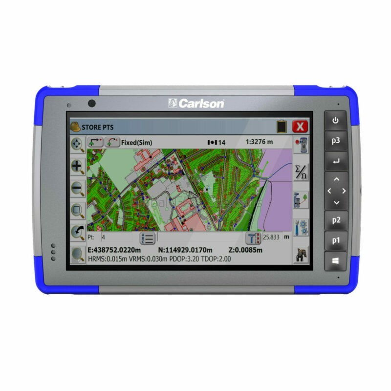
Carlson RT4
Get the best price for your setup
Contact our experts for the best possible price and configuration.
- Fast response
- Expert configuration advice
- No overpaying for features you do not need
Carlson RT4 is a rugged Windows field tablet and data collector built for land surveying, construction stakeout, site layout and GIS mapping. Designed for Carlson SurvPC, it gives field crews a large 7-inch touchscreen, physical function keys, long-range Bluetooth and all-day removable battery power for working with GNSS receivers and total stations on demanding sites.
The IP68-rated housing, strengthened display and MIL-STD-810G rugged design make the RT4 suitable for daily outdoor use in rain, dust and changing temperatures. STANDARD, CELL and GEO/CELL configurations allow users to select the connectivity and internal positioning functions that suit their field workflow.
- Run Carlson SurvPC for GNSS, total station, stakeout and field data collection workflows.
- Connect to survey instruments using long-range Bluetooth, Wi-Fi, USB and optional cellular connectivity.
- Work through a full field day with a removable battery rated for approximately 12–15 hours.
Carlson RT4 Highlights
| Display | 7 inch 1280 × 800 high-visibility capacitive touchscreen with Dragontrail glass |
|---|---|
| Operating system | Microsoft Windows 10 |
| Performance | Intel Pentium N4200 quad-core processor with 8 GB RAM |
| Ruggedness | IP68 waterproof and dustproof with MIL-STD-810G rugged design |
| Battery | Removable 43.2 Wh Li-Ion battery rated for approximately 12–15 hours |
| Connectivity | Long-range Bluetooth 5.0, dual-band Wi-Fi, USB and optional 4G LTE |
| Available versions | STANDARD, CELL and GEO/CELL |
| Internal GNSS | GEO models use a 72-channel GNSS receiver with 2–5 m typical standalone accuracy |
You may also like…
Valued customers:










Find RTK Networks
Search NTRIP providers and connect to reliable RTK correction services.
Description
Carlson RT4 rugged field tablet for surveying and construction
Carlson RT4 is a rugged Windows data collector designed for professional land surveying, construction layout, stakeout and GIS fieldwork. It provides the processing power and screen size of a compact tablet while retaining the physical controls, environmental protection and survey-instrument connectivity needed for regular outdoor use.
The RT4 is particularly well suited to surveyors and construction crews using Carlson SurvPC with external GNSS receivers, robotic total stations or conventional total stations. Project information can be collected, checked and edited directly in the field, helping reduce the amount of manual data handling required between the site and office.
Designed for Carlson SurvPC field workflows
Carlson developed the RT4 around its Windows-based SurvPC field software. This makes the tablet suitable for workflows such as topographic surveying, RTK GNSS measurement, construction stakeout, coordinate geometry, surface stakeout and total station data collection when the appropriate SurvPC modules and survey instruments are used.
For a land surveyor, the RT4 can act as the main controller connected to a GNSS rover or total station. A construction crew can use the same type of setup to stake points, lines, offsets and design elevations. GIS users can also use the Windows environment for field mapping and attribute collection.
Because the controller runs Windows rather than a restricted embedded operating system, project files can also be reviewed and managed with familiar desktop-style tools while still on site.
7 inch display for drawings maps and survey information
The RT4 uses a 7-inch 1280 × 800 display, providing considerably more working area than a traditional handheld survey controller. This is useful when viewing CAD drawings, maps, surfaces and graphical stakeout information in SurvPC.
The optically bonded high-visibility display is designed for outdoor viewing and uses chemically strengthened Dragontrail glass for additional resistance to impact and scratching. The touchscreen supports finger and small-tip stylus input and can be configured for different field conditions.
Carlson’s user manual provides dedicated touchscreen profiles for normal finger use, stylus operation, gloves and wet conditions. This gives crews more practical control when the weather or required PPE makes an ordinary consumer touchscreen difficult to operate.
Physical keys for field operation
A touchscreen is useful for working with drawings, but survey work often benefits from physical controls. The RT4 includes illuminated hardware keys, a four-way navigation pad and programmable function buttons alongside the touchscreen.
These controls can make common operations easier when the tablet is mounted on a survey pole or when the operator is wearing gloves. Programmable keys can also provide quicker access to frequently used functions rather than requiring every command to be selected from the screen.
Connect to RTK GNSS receivers and total stations
Long-range Bluetooth is one of the most important features of the Carlson RT4 for survey work. It allows the controller to communicate wirelessly with compatible GNSS receivers, robotic total stations and other surveying equipment supported by the field software.
This is particularly useful for robotic total station work, where the operator and controller move away from the instrument during one-person surveying or stakeout. For RTK GNSS, Bluetooth provides the data connection between the field controller and a compatible external rover receiver.
Wi-Fi and USB are also available for project transfer, peripheral connections and other field or office tasks. CELL configurations add 4G LTE hardware for workflows that require mobile internet connectivity.
Mobile internet for network RTK workflows
The CELL and GEO/CELL versions add integrated cellular connectivity. For surveyors using network RTK corrections, an internet connection can allow compatible SurvPC and GNSS configurations to connect to an NTRIP or other correction service without relying on a separate phone hotspot.
This can simplify a rover setup where the controller is used for both communication with the GNSS receiver and access to the correction network. Actual correction-service compatibility and availability depend on the connected receiver, software configuration, mobile network and correction provider.
Optional integrated GNSS for mapping and general positioning
GEO versions of the RT4 include an integrated 72-channel u-blox GNSS receiver and antenna. Carlson specifies typical standalone positioning accuracy of approximately 2 to 5 metres and support for real-time SBAS corrections such as EGNOS.
This integrated receiver is useful for general navigation, GIS mapping, geotagging photographs and other tasks where metre-level positioning is sufficient. It should not be confused with a survey-grade centimetre-level RTK receiver.
For cadastral surveying, precise construction stakeout and other high-accuracy work, the RT4 is normally used as the controller connected to an appropriate external RTK GNSS receiver or total station.
Built for rain dust and demanding construction sites
Consumer tablets are convenient in an office but can be vulnerable to dust, water and accidental drops. The Carlson RT4 was developed specifically for professional field conditions.
Its housing carries an IP68 rating for water and dust protection and is designed around MIL-STD-810G environmental test procedures. Carlson also specifies resistance to multiple drops onto concrete, together with impact-absorbing external bumpers.
The specified operating-temperature range is -20°C to 50°C, allowing the controller to be used across a wide range of surveying and construction environments. These characteristics make it suitable for crews working around earthmoving equipment, roads, utilities and undeveloped sites where ordinary office electronics may not be practical.
All day removable battery
The RT4 uses a removable 43.2 Wh lithium-ion battery with a specified operating time of approximately 12 to 15 hours on one charge. Actual runtime will depend on screen brightness, wireless communications, connected peripherals and the applications being used.
The removable design is useful for crews that work extended shifts or travel between remote sites. A discharged battery can be exchanged instead of waiting for the complete controller to recharge.
Carlson also designed the battery system for operation in cold field conditions, making the RT4 more appropriate for professional outdoor work than tablets intended primarily for indoor use.
Windows 10 with 8 GB RAM
The original Carlson RT4 uses Microsoft Windows 10 and a quad-core Intel Pentium N4200 processor with 8 GB of RAM. Storage configurations include 128 GB and, depending on version, 256 GB options, with a user-accessible MicroSDXC slot for additional storage.
For field crews this provides enough computing capability to run SurvPC while handling drawings, coordinate files and survey information directly on the controller. The Windows environment also allows the RT4 to be used for compatible Carlson office applications when required.
This can be useful for surveyors travelling between projects who want to perform basic file preparation, checking or data management without immediately returning to an office workstation.
Useful for land surveying
For land surveyors, the RT4 provides a large-screen controller for GNSS and total station measurement. Coordinate information, descriptions, linework and drawings can be viewed while measurements are being collected rather than relying on a separate field sketch.
When paired with a suitable RTK GNSS receiver, it can support centimetre-level field workflows through SurvPC. When connected to a robotic or conventional total station, the same controller can be used for optical surveying and setting out.
This flexibility is particularly useful for companies that use several types or brands of surveying instruments but want field crews to work with a consistent Carlson software interface.
Useful for construction layout and stakeout
Construction teams can use the RT4 to take design coordinates from the office into the field and stake them using connected surveying equipment. Foundations, utilities, kerbs, roads, building corners and other design features can be located from digital project information.
The large screen is useful when field staff need visual context from a CAD drawing rather than working from point numbers alone. Crews can see the surrounding project geometry while navigating to the required stakeout position.
For surveyors supporting machine-control or site-grading operations, the controller can also provide a practical connection between office-prepared design information and field verification measurements.
Useful for GIS and asset mapping
The RT4 is also suitable for GIS fieldwork where a rugged Windows controller is preferred. The GEO version’s internal GNSS can provide metre-level positioning for general mapping, while an external GNSS receiver can be used where the project requires greater accuracy.
Typical applications include mapping utilities, street furniture, environmental features, construction assets and other objects that need a geographic location together with descriptive field information.
The integrated camera available on applicable models can also support geotagged field photographs, giving GIS teams another way to document the condition or identity of mapped features.
STANDARD CELL and GEO CELL configurations
The Carlson RT4 was offered in several configurations so users could select the hardware required for their work. The STANDARD configuration provides the main tablet and wireless survey-controller functionality. CELL adds cellular communication, while GEO/CELL combines cellular hardware with the integrated GNSS receiver.
The correct version depends on how the controller will be used. A surveyor working exclusively with an external RTK receiver may not need an internal GNSS board, while a GIS user may benefit from integrated positioning. Network RTK users may prefer built-in cellular connectivity where supported.
Carlson RT4 or Carlson RT4 Plus
The product on this page is the original Carlson RT4. Carlson subsequently introduced the RT4+, which uses newer hardware including Windows 11, a faster Intel processor, 16 GB RAM and 256 GB storage.
This distinction is important when selecting accessories, comparing specifications or planning software deployment. Existing RT4 units remain useful as rugged SurvPC controllers, but buyers comparing new hardware should check which RT4 generation is being supplied and whether its operating system and performance match the intended software workflow.
Carlson RT4 from Global GPS Systems
Global GPS Systems can help determine which Carlson RT4 configuration is appropriate for your surveying, construction or GIS workflow and whether the controller will communicate correctly with the GNSS receiver or total station you intend to use.
For customers building a complete RTK setup, Global GPS Systems can also help match the data collector with compatible GNSS hardware, Carlson SurvPC and the correction method used in the field. This is especially important when deciding whether integrated cellular connectivity or internal GNSS is useful for the way your crews actually work.
Specifications
Carlson RT4 Rugged Data Collector Specifications
Product Overview
| Product name | Carlson RT4 |
|---|---|
| Product type | Rugged Windows field data collector / tablet |
| Product generation | Original Carlson RT4; separate from the newer Carlson RT4+ |
| Primary applications | Land surveying, GNSS data collection, total station operation, stakeout, construction layout, GIS mapping and field-to-office data processing |
| Typical users | Land surveyors, construction layout professionals, civil engineers, GIS professionals and field data collection teams |
| Field software | Designed for Carlson SurvPC |
| Office software compatibility | Can run compatible Carlson Windows office software |
| Esri compatibility | Designed for applicable Esri OEM / GIS field workflows |
| Operating system class | Full Windows tablet rather than a dedicated embedded survey controller |
Available Models
| Model | 4G LTE | Integrated GNSS |
|---|---|---|
| STANDARD | No integrated cellular modem | No integrated GNSS board |
| CELL | Yes | No integrated GNSS board |
| GEO/CELL | Yes | Yes |
Processor and Operating System
| Processor | Intel Pentium N4200 |
|---|---|
| CPU cores | Quad-core |
| Graphics | Intel HD Graphics |
| Operating system | Microsoft Windows 10 Pro |
| Supported interface languages | English, French, Spanish, German and Portuguese |
| Security hardware | TPM (Trusted Platform Module) 2.0 |
Memory and Storage
| RAM | 8 GB LPDDR4 |
|---|---|
| Internal storage | 128 GB flash storage in the primary technical specification |
| Additional published storage option | 256 GB configurations are referenced in Carlson marketing material and by Global GPS Systems |
| Expandable storage | User-accessible microSDXC card slot |
| Memory card access | microSD / SDHC-compatible card location underneath the battery-compartment card retainer |
Display
| Display size | 7 in (178 mm) diagonal active viewing area |
|---|---|
| Resolution | 1280 × 800 pixels |
| Resolution class | WXGA |
| Display type | High-visibility backlit color LCD |
| Outdoor visibility | IllumiView high-visibility display designed for sunlight readability |
| Screen orientation | Portrait and landscape |
| Automatic rotation | Supported |
| Ambient light sensor | Integrated |
Touchscreen
| Touch technology | Projected capacitive multi-touch |
|---|---|
| Finger input | Supported |
| Stylus input | Supports small-tip capacitive stylus |
| Glove operation | Supported using the appropriate touchscreen profile |
| Wet-condition operation | Supported using the Wet touchscreen profile with finger or compatible soft-tip stylus |
| Optical bonding | Yes |
| Cover glass | Chemically strengthened Dragontrail High Ion-Exchange (HIE) glass |
| Screen protection | Designed for increased impact and scratch resistance |
| Touchscreen profiles | Finger and Stylus, Finger, Stylus, Wet and Glove |
Physical Keypad
| Backlighting | Adjustable LED backlit keys |
|---|---|
| Navigation pad | Four-way directional navigation pad |
| Windows / Home key | Integrated |
| Power key | Integrated |
| Enter key | Integrated |
| Programmable keys | 3 user-programmable function keys |
| OEM key configuration | Configurable / customizable |
Integrated GNSS – GEO/CELL Model
| GNSS availability | Integrated on GEO/CELL configurations |
|---|---|
| GNSS receiver | u-blox NEO-M8N |
| GNSS tracking channels | 72 |
| Typical standalone accuracy | 2–5 m |
| GNSS antenna | Integrated internal antenna |
| SBAS | Integrated real-time SBAS receiver |
| Documented SBAS services | WAAS, EGNOS and other compatible SBAS services |
| Windows GNSS integration | Position data available through the Windows Sensor and Location platform |
| Legacy NMEA access | NMEA data can be exposed through a virtual serial COM port for compatible applications |
| GNSS configuration utility | Juniper Geode Connect |
Optional Enhanced GNSS Configuration
| Optional receiver | u-blox NEO-M8T |
|---|---|
| Availability | Upgrade option for applicable RT4 Geo configurations |
| Raw GNSS data | Supports data collection for post-processing |
| External GNSS antenna | External antenna connection supported with the NEO-M8T option |
| Automatic antenna selection | Automatically uses the connected external antenna when detected; otherwise uses the internal antenna |
| Positioning application | Suitable for enhanced GIS / mapping workflows; it is not a replacement for a survey-grade RTK GNSS receiver when centimeter-level positioning is required |
Wireless Connectivity
| Bluetooth | Bluetooth 5.0 + EDR |
|---|---|
| Bluetooth class | Class 1.5 |
| Bluetooth Low Energy | BLE supported |
| Long-range Bluetooth | Smart Ready long-range wireless technology |
| Wi-Fi standards | IEEE 802.11 a/b/g/n/ac |
| Wi-Fi bands | 2.4 GHz and 5 GHz |
| Cellular modem | 4G LTE on CELL and GEO/CELL configurations |
| SIM type | Micro SIM for cellular-equipped configurations |
| Cellular service | Data service through compatible mobile network providers; regional band and carrier compatibility depends on configuration |
Ports and Interfaces
| USB | 1 × full-size USB 3.0 host port |
|---|---|
| Audio | 1 × 3.5 mm audio jack |
| Power input | 12 VDC input jack |
| Docking interface | Integrated docking connector |
| Docking power | Supported |
| Docking USB | USB 2.0 connection supported |
| Docking HDMI | Supported |
| Docking Ethernet | Supported |
| Optional serial port | RS-232 9-pin D-Sub |
| RS-232 accessory power | 5 VDC power output supported on the optional serial connector |
Audio
| Speaker | High-output integrated speaker designed for noisy field environments |
|---|---|
| Microphones | Dual digital microphones |
| Audio jack | 3.5 mm |
Cameras and Geotagging
| Camera availability | Configuration-dependent optional feature |
|---|---|
| Rear camera | 8 MP |
| Rear illumination | LED illumination / flash |
| Front camera | 2 MP |
| Still photography | Supported |
| Video recording | Supported |
| Juniper Geotagging | Can embed date, time and GNSS position information with photographs when positioning data is available |
Integrated Sensors
| Ambient light sensor | Yes |
|---|---|
| Electronic compass | Yes |
| Accelerometer | Yes |
| Gyroscope | Yes |
| Automatic screen rotation | Supported using integrated orientation sensors |
Battery and Power
| Primary battery | Removable rechargeable lithium-ion battery |
|---|---|
| Battery capacity | 43.2 Wh |
| Published runtime | Approximately 12–15 hours per charge depending on configuration, radios, display usage and applications |
| Field replaceable | Yes |
| Cold-weather optimization | Yes |
| Optional internal battery | Available on applicable configurations |
| Additional internal-battery runtime | Approximately 5–6 additional hours according to the RT4 manual |
| Battery hot swap | The removable battery can be changed while the tablet remains powered when the optional internal battery is installed |
| External power | 12 VDC |
| Approved charger minimum output | 12 VDC, minimum 1.67 A |
Physical Specifications
| Width | 137 mm (5.40 in) |
|---|---|
| Height | 215 mm (8.48 in) |
| Depth | 35 mm (1.36 in) |
| Weight | Approximately 680–907 g (1.5–2.0 lb), depending on battery and hardware configuration |
| Enclosure design | Durable, chemical-resistant and shock-resistant rugged enclosure |
| Bumpers | Impact-absorbing overmolded bumpers |
| Ergonomics | Lightweight, easy-grip field design with integrated hand-strap attachment points |
Environmental Specifications
| Ingress protection | IP68 |
|---|---|
| Water resistance | Waterproof to the applicable IP68 test requirements with all covers and battery door correctly installed |
| Dust resistance | Dustproof to IP68 requirements |
| Operating temperature | -20°C to +50°C (-4°F to +122°F) |
| Storage temperature | -30°C to +70°C (-22°F to +158°F) |
| Drop resistance | Multiple drops from approximately 1.2–1.5 m (4 ft) onto concrete |
| Rugged standard | Designed to MIL-STD-810G test procedures |
MIL-STD-810G Tests
| Test | Method |
|---|---|
| Low pressure / altitude | Method 500.5 |
| High temperature | Method 501.5 |
| Low temperature | Method 502.5 |
| Temperature shock | Method 503.5 |
| Rain | Method 506.5 |
| Humidity | Method 507.5 |
| Sand and dust | Method 510.5 |
| Immersion | Method 512.5 |
| Vibration | Method 514.6 |
| Shock | Method 516.6 |
Certifications and Standards
| FCC | FCC Class B |
|---|---|
| European certification | CE marking |
| EU radio compliance | Documented compliance with applicable EU radio equipment requirements |
| Canada | Industry Canada / ICES-003 Class B compliance |
| Electrical safety | EN60950 |
| RoHS | RoHS 2 compliant |
| Hazardous-location option | Optional Class I, II and III, Division 2 configuration documented by Carlson |
Optional Hardware Features and Accessories
| 4G LTE modem | Optional / included with CELL and GEO/CELL configurations |
|---|---|
| Integrated GNSS | Available with GEO configurations |
| NEO-M8T GNSS upgrade | Optional with raw-data output and external GNSS antenna support |
| Front / rear cameras | Optional according to RT4 hardware configuration |
| RS-232 port | Optional 9-pin D-Sub |
| Internal auxiliary battery | Optional |
| Office docking station | Optional |
| Vehicle dock | Optional |
| External battery charger | Optional |
| Barcode imager | Optional on applicable RT4 configurations |
| Barcode support | Supports applicable 1D, composite, postal and 2D barcode types |
| Barcode pistol grip | Optional for appropriately configured units |
| UHF RFID reader | Optional on applicable hardware configurations |
Carlson SurvPC Workflow
| Primary data collection software | Carlson SurvPC |
|---|---|
| GNSS rover control | Supported through SurvPC with compatible external GNSS receivers |
| Total station control | Supported through SurvPC with compatible conventional and robotic total stations |
| Construction stakeout | Supported through Carlson SurvPC |
| Survey data collection | Supported through Carlson SurvPC |
| GIS field collection | Supported through applicable Carlson and Esri software workflows |
| Field-to-office workflow | Project data can be transferred to compatible Carlson office software |
| SurvPC license | Carlson's RT4 datasheet describes the RT4 as bundled with SurvPC; confirm the exact software license and version supplied with the selected seller configuration |
Model Configuration Comparison
| Feature | STANDARD | CELL | GEO/CELL |
|---|---|---|---|
| Windows 10 | Yes | Yes | Yes |
| 8 GB RAM | Yes | Yes | Yes |
| 7-inch display | Yes | Yes | Yes |
| Wi-Fi | Yes | Yes | Yes |
| Long-range Bluetooth | Yes | Yes | Yes |
| 4G LTE | No | Yes | Yes |
| Integrated GNSS board | No | No | Yes |
| Integrated GNSS typical accuracy | Not applicable | Not applicable | 2–5 m |
| Survey-grade external GNSS operation | Supported through compatible SurvPC-connected receiver | Supported through compatible SurvPC-connected receiver | Supported through compatible SurvPC-connected receiver |
Manufacturer Standard Accessories
| Item | Quantity | Notes |
|---|---|---|
| Removable Li-ion battery | 1 | 43.2 Wh |
| AC wall charger | 1 | International plug kit |
| Capacitive small-tip stylus | 1 | Includes tether |
| Quick Start Guide | 1 | Manufacturer documentation |
| Hand strap | 1 | Field handling accessory |
| Connector port dust cover | 1 | Protects exposed connector area |
Global GPS Systems Listed Package
| Item | Quantity | Notes |
|---|---|---|
| Carlson RT4 rugged data collector | 1 | Model configuration selected separately |
| Removable battery | 1 | Field-replaceable battery |
| 30 W universal power supply | 1 | Includes international adapters |
| Hand strap | 1 | For secure field handling |
| RT4 carrying case | 1 | Listed in the current Global GPS Systems package |
Warranty and Product Generation Notes
| Manufacturer warranty | 2 years in the original RT4 technical documentation |
|---|---|
| Service plans | Documented as available |
| Current-generation successor | Carlson RT4+ is a newer product with different processor, memory, storage, Windows version, cameras, GNSS and connectivity specifications |
| RT4 identification | The original RT4 uses the Intel Pentium N4200, Windows 10 and 8 GB LPDDR4 platform; specifications for the RT4+ should not be applied to this model |
| Storage configuration | Official RT4 technical specifications identify 128 GB flash storage, while other Carlson literature and the current Global GPS Systems listing also reference 256 GB configurations |
| Optional hardware | GNSS, cellular modem, cameras, RS-232, internal battery, barcode and RFID hardware depend on the exact RT4 configuration |
Specifications and package contents may vary by configuration, region or manufacturer update. Always check the current configuration before ordering.
Additional information
| Weight | 2 kg |
|---|---|
| Dimensions | 20 × 25 × 10 cm |
Reviews (2)
2 reviews for Carlson RT4
Only logged in customers who have purchased this product may leave a review.
FAQ
Carlson RT4 Data Collector FAQ
Carlson RT4, Applications & Configurations
What is the Carlson RT4?
The Carlson RT4 is a rugged Windows data collector and field tablet designed for land surveying, construction layout, stakeout and GIS mapping. It is designed to run Carlson SurvPC and can communicate with compatible GNSS receivers and total stations while providing a full Windows environment for field data collection and processing.
Who is the Carlson RT4 designed for?
The RT4 is designed for land surveyors, construction layout crews, civil engineering teams, GIS professionals and other field users who need a rugged Windows controller for collecting measurements, controlling survey equipment and working with project data outdoors.
Is the Carlson RT4 a data collector or a GNSS receiver?
The RT4 is primarily a rugged data collector. The STANDARD and CELL versions do not include the integrated GNSS board. The GEO/CELL version adds an internal GNSS receiver for general positioning and mapping. For centimetre-level RTK surveying, the RT4 is normally connected to an external survey-grade RTK GNSS receiver.
What Carlson RT4 models are available?
The RT4 was produced in three main configurations: STANDARD, CELL and GEO/CELL. STANDARD provides the core rugged tablet and wireless connectivity. CELL adds integrated 4G LTE. GEO/CELL adds both 4G LTE and an internal GNSS receiver.
What is the difference between the Carlson RT4 and RT4+?
The RT4+ is the newer generation of Carlson's rugged 7-inch data collector. The original RT4 uses Windows 10, an Intel Pentium N4200 processor and 8 GB of RAM, while the RT4+ uses newer hardware, Windows 11, 16 GB of RAM and a faster processor. Both are designed around Carlson field surveying workflows, but their hardware specifications are different.
Can the Carlson RT4 also be used in the office?
Yes. Because the RT4 runs full Microsoft Windows, it can be used with compatible Carlson office software in addition to its field data-collection role. This can make it easier to review, transfer and manage project information on the same computer used in the field.
SurvPC, GNSS & Survey Equipment
Does the Carlson RT4 run Carlson SurvPC?
Yes. The Carlson RT4 was specifically designed for use with Carlson SurvPC, Carlson's Windows-based field surveying software. SurvPC can be used for GNSS surveying, total station measurements, stakeout, COGO, surfaces, roads and other field workflows depending on the software modules licensed.
Can the Carlson RT4 connect to an RTK GNSS receiver?
Yes. The RT4 can act as the field controller for compatible survey-grade GNSS receivers. Communication is commonly handled through long-range Bluetooth, allowing SurvPC to configure the receiver, monitor RTK status, collect survey points and perform stakeout.
Can the Carlson RT4 control a robotic total station?
Yes. When equipped with the appropriate Carlson SurvPC modules, the RT4 can control supported robotic total stations. Compatibility depends on the instrument model, communication method and the SurvPC version and modules installed on the tablet.
Can the Carlson RT4 be used with a conventional total station?
Yes. Carlson SurvPC supports conventional total station data collection as well as robotic and GNSS workflows. The RT4 therefore provides a single Windows field platform that can be used with different types of compatible surveying instruments.
How accurate is the built-in GNSS in the Carlson RT4 GEO/CELL model?
Carlson specifies typical accuracy of approximately 2 to 5 metres for the integrated GNSS receiver in the GEO/CELL model. It uses a u-blox NEO-M8N receiver with 72 tracking channels and real-time SBAS support such as WAAS and EGNOS. This internal GNSS is intended for general positioning and mapping rather than centimetre-level RTK surveying.
Can the Carlson RT4 use mobile internet for NTRIP corrections?
Yes. The CELL and GEO/CELL versions include 4G LTE connectivity. With a compatible data service and survey-grade GNSS receiver, the mobile connection can be used for internet-based field workflows such as accessing an NTRIP RTK correction service.
Display, Performance & Connectivity
What operating system does the Carlson RT4 use?
The original Carlson RT4 uses Microsoft Windows 10. This allows it to run full Windows surveying applications such as compatible versions of Carlson SurvPC rather than relying on a mobile-only operating system.
How much RAM and storage does the Carlson RT4 have?
The Carlson RT4 has 8 GB of LPDDR4 RAM. Carlson's RT4 datasheet specifies 128 GB of internal flash storage and a user-accessible MicroSDXC card slot. Some RT4 configurations offered by suppliers may provide additional storage, so the exact storage capacity should be confirmed for the unit being supplied.
What processor does the Carlson RT4 use?
The RT4 uses a quad-core Intel Pentium N4200 processor. Together with 8 GB of RAM, it is designed to handle field data collection, CAD viewing and Carlson SurvPC surveying workflows.
What size screen does the Carlson RT4 have?
The Carlson RT4 has a 7-inch IllumiView high-visibility display with a resolution of 1280 × 800 pixels. The screen automatically rotates between portrait and landscape orientation and is designed for visibility in bright outdoor conditions.
Can the Carlson RT4 touchscreen be used with gloves or in the rain?
Yes. The projected capacitive multi-touch display is designed for use with gloves, a small-tip capacitive stylus and in wet conditions. The display is optically bonded and protected by chemically strengthened Dragontrail glass for increased impact and scratch resistance.
What wireless connectivity does the Carlson RT4 provide?
The RT4 supports long-range Bluetooth Smart Ready and dual-band 2.4 GHz and 5 GHz Wi-Fi. CELL and GEO/CELL versions also include 4G LTE. These connections can be used for communication with compatible survey instruments, data transfer, internet access and network-based field workflows.
Battery, Durability & Field Use
How long does the Carlson RT4 battery last?
Carlson specifies approximately 12 to 15 hours of operation on one charge using the removable 43.2 Wh lithium-ion battery. Actual battery life depends on screen brightness, Bluetooth and Wi-Fi use, cellular connectivity, temperature and the applications running on the tablet.
Can the Carlson RT4 battery be replaced in the field?
Yes. The RT4 uses a removable lithium-ion battery that can be changed in the field. This allows crews to carry a charged spare battery when longer operating periods are required.
Is the Carlson RT4 waterproof and dustproof?
Yes. The Carlson RT4 has an IP68 ingress-protection rating, providing a high level of resistance to dust and water. It is designed for professional outdoor use where equipment can be exposed to rain, dirt and demanding jobsite conditions.
How rugged is the Carlson RT4?
The RT4 is designed to MIL-STD-810G test procedures for environmental conditions including temperature, rain, humidity, sand and dust, immersion, vibration and shock. Carlson also specifies resistance to multiple drops from approximately 1.2 to 1.5 metres onto concrete.
What temperature range can the Carlson RT4 operate in?
The specified operating temperature range is -20°C to +50°C (-4°F to 122°F). The specified storage temperature range is -30°C to +70°C (-22°F to 158°F).
What comes with the Carlson RT4?
The listed RT4 package includes a removable battery, universal power supply with international adapters, hand strap and carrying case. Carlson's original datasheet also lists a small-tip capacitive stylus with tether, quick-start guide and connector-port dust cover among the standard accessories. Exact contents should be confirmed for the specific package being supplied.

 GPS & GNSS
 Total Stations
 Data collectors
 Software
 Correction services
 Machine control
 External radio
 Marine
 Accessories
Vince Harris (verified owner) –
TY
Michael P. (verified owner) –
I’m currently away on holiday but can’t wait to start working with this equipment package.