

 GPS & GNSS
 Lidar scanning
 Total Station
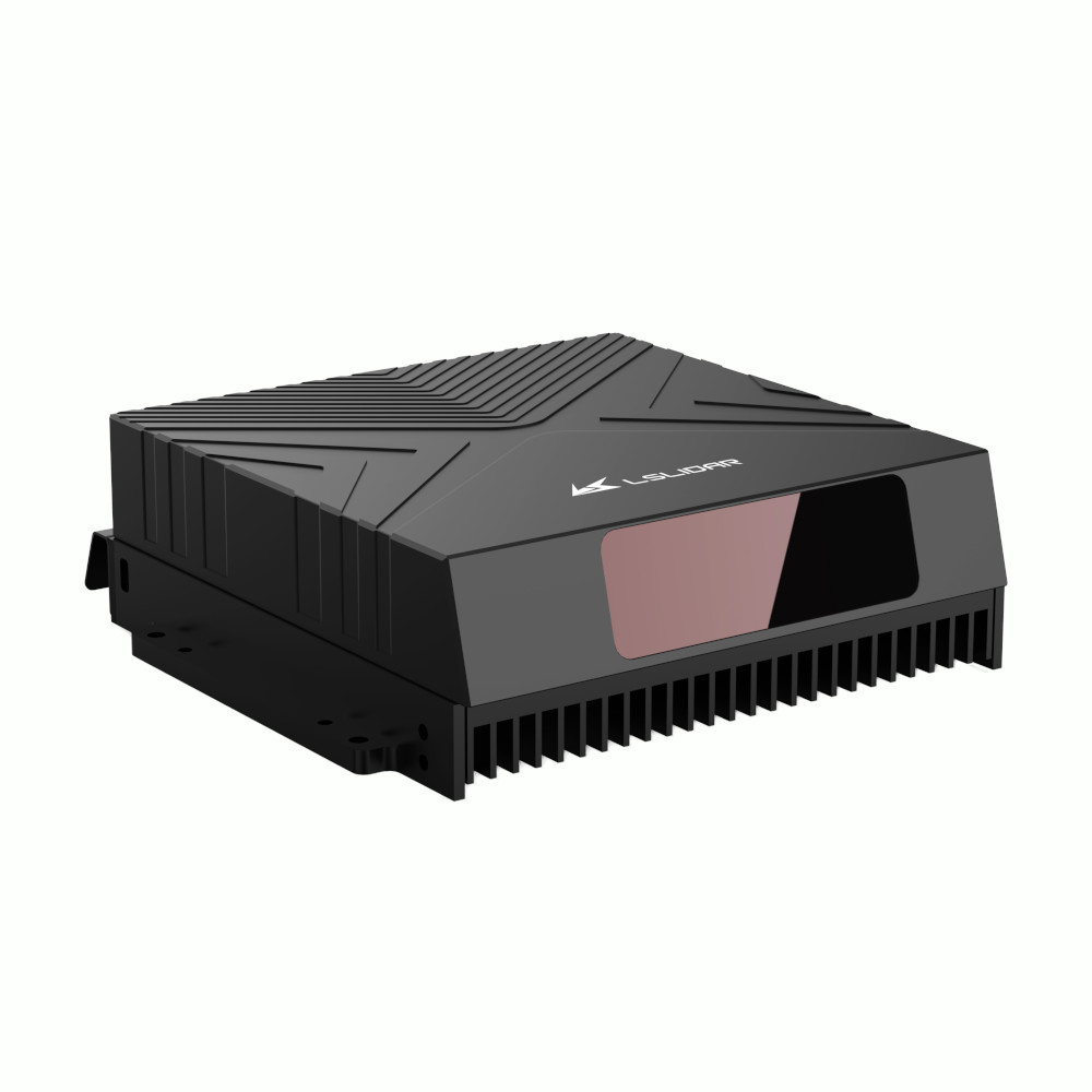
LS Lidar LS25D 500m Railway Intrusion Detection LiDAR
Get the best price for your setup
Contact us for expected delivery time.
- Fast response
- Expert configuration advice
- No overpaying for features you do not need
The LS Lidar LS25D is a high-resolution 1550 nm hybrid solid-state LiDAR designed for fixed railway intrusion detection, track monitoring and long-range obstacle detection. Its 120° × 25° field of view and fine angular resolution allow the system to identify small objects across the railway corridor, including pedestrians, animals, debris and falling objects. The LS25D provides 200 m detection at 10% reflectivity, a maximum range of up to 500 m and ±2 cm range accuracy, making it suitable for permanent rail safety and infrastructure monitoring installations.
LS Lidar LS25D Highlights
| LiDAR type | 1550 nm hybrid solid-state LiDAR |
|---|---|
| Detection range | 1.5–200 m at 10% reflectivity, up to 500 m maximum |
| Range accuracy | ±2 cm |
| Field of view | 120° horizontal × 25° vertical |
| Horizontal resolution | Approx. 0.0311° |
| Frame rate | 0.25 / 0.5 / 1 Hz |
| Protection | IP6K9K |
Valued customers:










Find RTK Networks
Search NTRIP providers and connect to reliable RTK correction services.
Description
High Resolution LiDAR for Railway Intrusion Detection
The LS Lidar LS25D is a long-range hybrid solid-state LiDAR developed specifically for railway monitoring and fixed-point intrusion detection. It uses a 1550 nm laser system and a wide 120° horizontal by 25° vertical field of view to monitor the track and surrounding corridor for people, animals, vehicles, debris and other objects that may create a safety risk.
Unlike a general-purpose mobile LiDAR, the LS25D is designed to be installed at a fixed position alongside or above the railway. Its strength is not high frame-rate vehicle perception, but detailed long-range scanning with very fine angular resolution. This allows the sensor to identify relatively small objects at substantial distances along the track.
200 Metre Detection at 10 Percent Reflectivity
The LS25D is specified for detection from approximately 1.5 to 200 metres at 10% target reflectivity, with a maximum detection range of up to 500 metres under suitable conditions.
The 10% reflectivity specification is particularly relevant for railway monitoring because many real-world obstacles are dark or return relatively little laser energy. Materials such as tyres, dark clothing, rocks and weathered infrastructure can be more difficult to detect than bright reflective targets. Stating the 200 m performance at 10% reflectivity therefore gives a more practical indication of what the LiDAR can do in the field than quoting maximum range alone.
Detect Small Objects at Long Distance
A defining feature of the LS25D is its ability to combine long-range detection with very fine angular resolution. LS Lidar specifically developed the sensor to identify small foreign objects within railway corridors, where early detection can give operators more time to assess and respond to hazards.
Manufacturer testing describes the LS25D as capable of detecting approximately 20 × 20 cm objects at 200 m. The sensor’s dense angular sampling can place several LiDAR measurement points on an object of this size, helping processing software distinguish it from the surrounding track environment.
120 Degree by 25 Degree Field of View
The LS25D provides a broad 120° horizontal field of view and 25° vertical coverage. This geometry is designed around railway corridors, allowing the sensor to observe a wide section of the tracks and surrounding area from one fixed mounting point.
The vertical field of view extends approximately ±12.5° around the sensor centreline. Correct mounting angle and installation height are important so the measurement area covers the intended track section while maintaining sufficient point density at the longest required distance.
Very Fine Angular Resolution
The newer LS25D specification lists horizontal angular resolution of approximately 0.0311°. Vertical resolution can be configured at approximately 0.05°, 0.025° or 0.0125° depending on the selected operating frequency.
Fine angular resolution means neighbouring measurements are positioned very close together. At long range, this helps maintain enough measurement points on smaller objects to allow them to be detected and classified by the monitoring system.
Adjustable High Density Scanning
The LS25D supports frame rates of approximately 0.25, 0.5 and 1 Hz. These values are lower than those of automotive obstacle-detection LiDAR because the sensor is optimised for extremely dense fixed-area scanning rather than rapidly refreshing a moving vehicle environment.
For a railway installation, this trade-off is practical. Trains and railway infrastructure follow a defined corridor, and a high-density point cloud can be more useful for reliably identifying smaller foreign objects than a very high refresh rate with fewer measurements per scan.
±2 cm Range Accuracy
The current LS Lidar brochure specifies ±2 cm range accuracy for the LS25D. This supports consistent positioning of detected objects within the monitored rail corridor.
Range accuracy describes the LiDAR measurement itself. The final position assigned to an obstacle will also depend on the mounting survey, sensor orientation, system calibration and any GNSS or coordinate transformation used to relate the LiDAR data to the railway infrastructure.
1550 nm Hybrid Solid State LiDAR
The LS25D uses a 1550 nm laser architecture. This wavelength allows LS Lidar to design the system around long-range detection while maintaining Class 1 eye-safety requirements under specified operating conditions.
The hybrid solid-state scanning architecture also avoids the continuously rotating external head found on many 360° mechanical LiDAR sensors. For a permanent trackside installation, the fixed 120° viewing area can be directed exactly where monitoring is required.
Railway Intrusion and Foreign Object Detection
The main purpose of the LS25D is to identify objects that should not be present within the railway corridor. Depending on the software connected to the sensor, detected objects can include pedestrians, animals, vehicles, rolling stones, fallen objects and other obstacles.
The LiDAR supplies distance and 3D contour information to the monitoring system. Detection or classification software can then determine whether an object enters a defined safety zone and generate an alert for railway operators or connected safety systems.
Industrial Ethernet Integration
The current LS25D uses Automotive Ethernet for point-cloud communication. Earlier documentation refers to Industrial Ethernet, so buyers integrating into an existing railway monitoring platform should confirm the exact interface supplied with the current hardware revision.
Ethernet output allows the dense point-cloud stream to be transferred to an industrial computer or railway monitoring controller where detection, classification and alarm logic can be performed.
12 to 36 VDC Power Input
The LS25D supports a 12–36 VDC input range and has a specified power consumption below approximately 30 W. This broad supply range simplifies integration into fixed infrastructure cabinets and railway monitoring installations using common industrial DC power systems.
For a permanent outdoor installation, power supply stability, surge protection, grounding and correct network isolation should be considered together with the LiDAR itself.
Designed for Permanent Outdoor Installation
The current LS25D specification gives an IP6K9K protection rating and an operating temperature range from approximately -40°C to +75°C. This allows the unit to be integrated into systems operating outdoors throughout the year.
The housing measures approximately 247.5 × 230.03 × 79 mm and weighs no more than around 2 kg. Its fixed installation should provide a rigid mounting point with a clear view of the monitored railway corridor.
Typical Applications
- Railway track intrusion detection
- Foreign object detection on railway lines
- Pedestrian and animal detection around tracks
- Rockfall and falling-object monitoring
- High-risk railway section monitoring
- Railway crossing and infrastructure safety systems
- Fixed long-range 3D corridor monitoring
LS25D Compared with the LS25E
The LS25D and LS25E are designed for different railway applications. The LS25D is primarily intended for fixed trackside monitoring and uses a lower frame rate with very fine resolution to detect small objects at long distances.
The LS25E is intended for vehicle or train-mounted use. It offers faster 10 or 20 Hz scanning and a longer specified 10% reflectivity range of approximately 250 m, making it better suited to continuously updating the scene ahead of a moving train.
For permanent monitoring of a high-risk section of track, the LS25D’s dense fixed-area scan is the more appropriate configuration. For onboard forward detection, the LS25E is the model designed around that workflow.
Buying the LS Lidar LS25D from Global GPS Systems
Global GPS Systems supplies professional LiDAR, GNSS and positioning equipment for infrastructure, surveying, transport and industrial monitoring projects worldwide. Our team can help evaluate the required detection distance, mounting geometry and system integration requirements for an LS25D railway monitoring installation.
For projects where the LiDAR must be tied into a surveyed coordinate system or combined with GNSS, cameras or other sensors, Global GPS Systems can also help select compatible positioning and measurement equipment for the complete installation.
Specifications
LSLiDAR LS25D Rail-Transport Hybrid Solid-State LiDAR Specifications
Product Overview
| Product name | LSLiDAR LS25D |
|---|---|
| Product family | LS25 Series |
| Product type | Rail-transport hybrid solid-state 3D LiDAR |
| Primary configuration | Fixed-point / trackside LiDAR for railway monitoring |
| Laser wavelength | 1550 nm |
| Laser-source technology | LS25 family documentation describes a 1550 nm fiber-laser architecture |
| Primary function | High-resolution railway scanning, obstacle-intrusion detection and 3D target identification |
| Primary installation | Trackside / fixed-point monitoring at railway ends and high-risk railway sections |
| Typical applications | Railway intrusion monitoring, falling-object detection, pedestrian and animal detection, vehicle detection, rockfall monitoring, track-area monitoring and intelligent railway safety systems |
Ranging Specifications
| Minimum detection range | 1.5 m |
|---|---|
| Maximum detection range | 200 m at 10% target reflectivity |
| Detection range specification | 1.5–200 m at 10% reflectivity |
| Range accuracy | ±3 cm |
| Long-range small-object capability | Designed to detect a 20 × 20 cm object at 200 m |
| 20 × 20 cm target at 200 m | Manufacturer specification lists a minimum of 4 point-cloud points; descriptive documentation states approximately 5–6 visible point-cloud pixels under the referenced test conditions |
Field of View
| Horizontal field of view | 120° |
|---|---|
| Vertical field of view | 25° |
| Combined field of view | 120° × 25° (H × V) |
| Field-of-view characteristic | Ultra-wide forward-facing sector optimized for fixed railway monitoring |
Frame Rate and Angular Resolution
| Frame Rate | Horizontal Resolution | Vertical Resolution |
|---|---|---|
| 1 FPS / 1 Hz | 0.03° | 0.05° |
| 2 FPS / 2 Hz | 0.06° | 0.05° |
| 4 FPS / 4 Hz | 0.07° | 0.075° |
Scanning Performance
| Selectable frame rates | 1 Hz, 2 Hz and 4 Hz |
|---|---|
| Best horizontal angular resolution | 0.03° at 1 Hz |
| Best vertical angular resolution | 0.05° at 1 Hz and 2 Hz |
| Manufacturer series-level point rate | Approximately 2,000,000 points/second in LSLiDAR rail-transport and product-handbook documentation |
| High-density scanning | Optimized to preserve small-object detail at long railway-monitoring distances |
Published Point-Rate Documentation
| Documentation | 1 Hz | 2 Hz | 4 Hz |
|---|---|---|---|
| LSLiDAR rail-transport / product-handbook summary | Approximately 2,000,000 points/second | ||
| Older dedicated LS25 Product Introduction | 20,480,000 pts/s | 10,240,000 pts/s | 5,897,000 pts/s |
Point-Rate Documentation Note
| Current specification treatment | LSLiDAR publications contain conflicting LS25D point-rate figures. Multiple broader manufacturer product and rail-transport documents summarize the LS25D at approximately 2 million points/second, while an older dedicated LS25 PDF lists substantially higher mode-specific values. |
|---|---|
| Integration recommendation | When point throughput is critical, confirm the actual output rate and firmware configuration of the exact production LS25D unit before designing the processing and network hardware. |
Obstacle Detection Capabilities
| Railway intrusion detection | Supported application |
|---|---|
| Pedestrian detection | Supported application |
| Animal detection | Supported application |
| Vehicle detection | Supported application |
| Falling-object detection | Supported application |
| Rolling-stone / rockfall detection | Supported application |
| Object distance information | Available from LiDAR point-cloud processing |
| 3D object contour information | Supported through point-cloud processing |
| Small-object detection | 20 × 20 cm objects documented at up to 200 m under the manufacturer's reference conditions |
Point Cloud Output
| Output type | 3D point cloud |
|---|---|
| Point-cloud density | High-density output optimized for precise railway obstacle detection |
| Target localization | Distance and spatial information can be derived from the point cloud |
| Target contour extraction | Supported by compatible point-cloud processing software |
| Vision fusion | LSLiDAR railway-monitoring solutions support fusion of LiDAR point-cloud information with visual sensors |
Communication Interface
| Primary communication interface | Industrial Ethernet |
|---|---|
| Point-cloud transmission | Industrial Ethernet output to the host processing system |
| System integration | Designed for fixed railway-monitoring computers, intelligent transportation systems and compatible edge-processing platforms |
Electrical Specifications
| Input voltage | 12–36 VDC |
|---|---|
| Power-supply type | Wide-range DC input for fixed industrial installation |
| Power consumption | Not specified in the reviewed model-specific LSLiDAR LS25D specification table |
Environmental Specifications
| Ingress protection | IP67 |
|---|---|
| Operating temperature | -40°C to +60°C |
| Dust protection | Dust-tight according to the specified IP67 enclosure rating |
| Water protection | Protected against temporary immersion according to the specified IP67 enclosure rating when correctly installed |
| Outdoor operation | Designed for permanent railway and trackside installations within the specified environmental limits |
| Vibration resistance | Manufacturer and seller railway material describe strong vibration resistance; a numeric model-specific vibration value is not provided in the reviewed LS25D specification table |
| Shock resistance | Manufacturer and seller railway material describe strong shock resistance; a numeric model-specific shock value is not provided in the reviewed LS25D specification table |
Physical Specifications
| Length | 247.5 mm |
|---|---|
| Width | 244 mm |
| Height | 76 mm |
| Overall dimensions | 247.5 × 244 × 76 mm |
| Weight | ≤2 kg |
| Installation style | Fixed trackside / roadside-style installation |
Railway Monitoring Features
| Active monitoring | Continuously scans the monitored railway environment |
|---|---|
| All-time operation | Designed for 24/7 monitoring |
| Day / night operation | Active LiDAR sensing allows operation without relying on visible ambient illumination |
| Anti-glare capability | Manufacturer rail-transport documentation highlights resistance to natural and high-intensity light interference |
| Anti-interference design | Documented as a core LS25 railway-monitoring feature |
| Real-time warning integration | Point-cloud processing can be integrated with warning terminals and alarm systems |
| Vision-sensor fusion | Supported in LSLiDAR intelligent railway-monitoring solutions |
| Target attribute extraction | Compatible processing systems can extract location, distance, volume / contour and target information from LiDAR data |
Typical Trackside Installation Areas
| Railway main line | Supported application |
|---|---|
| Road / railway intersections | Supported application |
| Parallel road and railway sections | Supported application |
| Construction-adjacent railway sections | Supported application |
| Rockfall / collapse-prone sections | Supported application |
| High-risk railway areas | Designed for continuous obstacle-intrusion monitoring |
Applicable Rail Environments
| High-speed rail | Supported application |
|---|---|
| Bullet trains | Supported application |
| Conventional rail | Supported application |
| Subway systems | Supported application |
| Light rail | Supported application |
LS25D and LS25E Comparison
| Specification | LS25D | LS25E |
|---|---|---|
| Primary installation | Fixed-point / trackside | Train-mounted |
| Laser wavelength | 1550 nm | 1550 nm |
| Detection range | 1.5–200 m at 10% reflectivity | 1.5–300 m maximum; 250 m at 10% reflectivity |
| Range accuracy | ±3 cm | ±3 cm |
| Horizontal FOV | 120° | 120° |
| Vertical FOV | 25° | 25° |
| Frame rate | 1 / 2 / 4 Hz | 10 / 20 Hz |
| Best horizontal resolution | 0.03° | 0.09° |
| Best vertical resolution | 0.05° | 0.2° |
| Manufacturer summary point rate | Approximately 2,000,000 pts/s | 1,700,000 pts/s |
| Communication | Industrial Ethernet | Industrial Ethernet |
| Input voltage | 12–36 VDC | 12–36 VDC |
| Ingress protection | IP67 | IP67 |
| Operating temperature | -40°C to +60°C | -40°C to +60°C |
| Weight | ≤2 kg | ≤2 kg |
| Dimensions | 247.5 × 244 × 76 mm | 220 × 220 × 45 mm |
Model Identification Notes
| LS25D range | The model-specific LS25D manufacturer specification is 1.5–200 m at 10% reflectivity. |
|---|---|
| 300 m LS25 claim | The 300 m maximum range appearing in general LS25 family descriptions applies to the LS25E train-mounted model, not the LS25D fixed-point model. |
| LS25D specialization | Prioritizes very high angular resolution for fixed long-distance obstacle monitoring rather than the higher 10–20 Hz frame rate used by the moving-platform LS25E. |
| Critical configuration check | Point-rate specifications differ between LSLiDAR publications, so data throughput should be confirmed against the datasheet and firmware supplied with the exact LS25D production unit. |
Manufacturer Documentation Basis
| Manufacturer | LSLiDAR / Shenzhen Leishen Intelligent System Co., Ltd. |
|---|---|
| Dedicated documentation researched | LS25 Rail Transport Hybrid Solid-State LiDAR Product Introduction |
| Additional documentation researched | LSLiDAR Intelligent Rail Transit Brochure and LSLiDAR product handbook |
| Seller model researched | Global GPS Systems LS LiDAR LS25D |
| Specification revision note | Manufacturer publications contain different point-rate summaries and the LS25 family includes both LS25D and LS25E configurations. Model-specific LS25D ranging, FOV, resolution, environmental and physical specifications are used here where available. |
Specifications and package contents may vary by configuration, region or manufacturer update. Always check the current configuration before ordering.
Reviews (0)
Only logged in customers who have purchased this product may leave a review.
FAQ
LS LiDAR LS25D FAQ
LS25D LiDAR & Railway Applications
What is the LS LiDAR LS25D?
The LS LiDAR LS25D is a long-range hybrid solid-state 3D LiDAR designed primarily for fixed railway intrusion detection and track monitoring. It uses a 1550 nm fibre laser and a wide 120° × 25° field of view to detect objects on or close to railway tracks and provide information including distance and 3D object contours.
What is the LS25D mainly used for?
The LS25D is designed for fixed monitoring of railway tracks and other high-risk rail areas. Typical applications include detecting pedestrians, animals, vehicles, rockfalls, fallen objects and other obstacles that could enter the railway clearance envelope.
Is the LS25D a 3D LiDAR?
Yes. The LS25D scans horizontally and vertically to produce three-dimensional point cloud information. This allows a monitoring system to determine both the position and 3D contour of an object rather than only measuring a single distance.
What is hybrid solid-state LiDAR?
Hybrid solid-state LiDAR uses a compact internal scanning system instead of the large continuously rotating assembly commonly found in mechanical 360° LiDAR sensors. The LS25D therefore monitors a defined 120° × 25° area with high angular resolution, making it well suited to fixed installations looking along railway tracks.
What types of obstacles can the LS25D detect?
The LS25D is intended to detect objects such as people, animals, vehicles, falling objects, rolling stones and other foreign objects that enter a monitored railway area. The LiDAR supplies distance and 3D contour information that can be used by compatible detection and warning software.
Can the LS25D operate continuously for railway monitoring?
Yes. The LS25D is designed for continuous 24-hour railway monitoring. Its rugged environmental design, long-range 1550 nm sensing technology and resistance to interference, vibration and shock make it suitable for permanent installation at critical railway locations.
Range, Accuracy & Resolution
What is the detection range of the LS LiDAR LS25D?
The LS25D is specified to detect targets from approximately 1.5 metres to 200 metres at 10% reflectivity. Current LS LiDAR documentation also lists a maximum detection capability of up to approximately 500 metres under suitable target and environmental conditions.
How accurate is the LS25D?
Current LS LiDAR documentation specifies ranging accuracy of approximately ±2 cm. Earlier LS25 documentation listed approximately ±3 cm, so the exact specification should be confirmed for the supplied hardware revision. System-level detection performance also depends on installation, target characteristics and environmental conditions.
What is the field of view of the LS25D?
The LS25D provides a 120° horizontal field of view and a 25° vertical field of view, approximately ±12.5° vertically. This wide field is designed to cover railway tracks and the surrounding clearance area from a fixed monitoring position.
What is the horizontal angular resolution of the LS25D?
The LS25D provides very fine horizontal angular resolution of approximately 0.0311°. This high angular density is important for identifying relatively small objects at long distances.
What is the vertical angular resolution of the LS25D?
The LS25D supports fine vertical resolution, with current documentation listing settings down to approximately 0.0125° and other operating modes including approximately 0.025° and 0.05°. Available resolution is related to the selected scanning configuration.
Can the LS25D detect small objects at long distances?
Yes. The LS25D is specifically designed for high-resolution long-range obstacle detection. LS LiDAR states that a 20 × 20 cm object can still produce multiple point cloud measurements at a distance of approximately 200 metres, allowing suitable software to identify small foreign objects on or near the railway.
How many measurement points does the LS25D generate?
The LS25D can generate approximately 2 million measurement points per second. The high point rate, combined with its fine angular resolution, provides detailed 3D information for railway intrusion monitoring and object detection.
LS25D vs LS25E, Laser & Integration
What is the difference between the LS25D and LS25E?
The LS25D is designed primarily for fixed trackside or track-end monitoring and prioritises very high spatial resolution. The LS25E is designed primarily for installation on moving trains and uses much faster 10 or 20 Hz scanning. The LS25E also provides a longer specified 10%-reflectivity range, while the LS25D is optimised for accurately identifying relatively small objects from a fixed monitoring location.
What laser wavelength does the LS25D use?
The LS25D uses a 1550 nm fibre laser developed by LS LiDAR. The 1550 nm architecture is designed for high-performance long-range detection and provides strong resistance to environmental light interference.
How does the LS25D measure distance?
The LS25D uses Time of Flight technology. Laser pulses are transmitted toward the monitored area and the sensor measures how long reflected light takes to return. The measured distance is combined with the horizontal and vertical scan angles to calculate three-dimensional points.
What communication interface does the LS25D use?
The LS25D uses a high-speed Ethernet interface for transmitting point cloud and sensor information to an external processing system. Current manufacturer documentation lists Automotive Ethernet for the LS25D configuration.
Does the LS25D identify obstacles by itself?
The LS25D supplies detailed 3D point cloud, distance and contour information. Classification of an object as a pedestrian, animal, vehicle, rock or another type of obstacle is normally performed by the connected perception, intrusion-detection or railway safety software using the LiDAR measurements.
Can the LS25D be integrated into an automatic railway warning system?
Yes. This is a primary application of the LS25D. Point cloud information can be processed by a compatible monitoring system to detect an intrusion, determine its location and characteristics and then generate information for railway control, signalling or warning systems according to the design of the complete installation.
Power, Durability & Installation
What power supply does the LS25D require?
The LS25D supports approximately 12 to 36 VDC input power. Current manufacturer documentation specifies power consumption below approximately 30 W. The power system should be designed according to the requirements of the complete permanent installation.
Is the LS25D waterproof and dustproof?
Yes. Current LS LiDAR documentation specifies an IP6K9K environmental protection rating for the LS25D. This provides a high level of protection against dust and high-pressure water exposure when the sensor and connections are correctly installed.
What temperature range can the LS25D operate in?
Current manufacturer specifications list an operating temperature range of approximately -40°C to +75°C. This wide range is intended to support permanent outdoor railway installations in demanding climates.
Is the LS25D resistant to vibration and shock?
Yes. The LS25D is designed with resistance to vibration and impact for railway environments. This is important for installations close to active tracks where passing trains can continuously expose monitoring equipment to vibration and mechanical disturbance.
How large and heavy is the LS LiDAR LS25D?
Current LS LiDAR documentation lists dimensions of approximately 247.5 × 230 × 79 mm and a weight of no more than approximately 2 kg. The compact fixed housing is designed for permanent mounting on railway infrastructure and other monitoring structures.
Where should the LS25D be installed?
The LS25D is intended primarily for fixed installation at railway track ends, high-risk sections, platforms and areas where foreign-object intrusion needs to be monitored. The sensor should have an unobstructed view of the required detection zone, and its mounting position, height and orientation should be accurately configured so the complete 120° × 25° field of view covers the required railway clearance area.
 GPS & GNSS
 Total Stations
 Data collectors
 Software
 Correction services
 Machine control
 External radio
 Marine
 Accessories
Reviews
There are no reviews yet