


 GPS & GNSS
 Lidar scanning
 Total Station
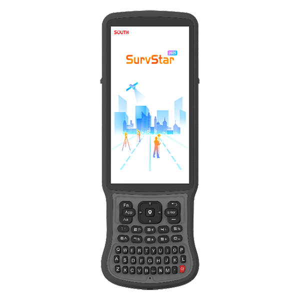
SOUTH H9 Rugged Android GNSS Data Controller 4G
Get the best price for your setup
Contact our experts for the best possible price and configuration.
- Fast response
- Expert configuration advice
- No overpaying for features you do not need
The SOUTH H9 is a rugged Android data collector for GNSS surveying, RTK positioning, construction layout, GIS mapping, drone ground control, and field engineering. It runs survey applications such as SurvStar on Android 12 and connects to GNSS receivers through Bluetooth, 4G cellular, dual-band Wi-Fi, and NFC. The 6-inch sunlight-readable display, full QWERTY keypad, and backlit keys support practical data entry in bright outdoor conditions. With a 7700mAh battery rated for up to 20 hours, IP67 protection, and 1.5m drop resistance, the H9 is suited to demanding daily fieldwork. Its 4GB RAM, 64GB storage, 13MP autofocus camera, and USB-C OTG support help crews manage survey projects, documentation, and data transfer efficiently.
SOUTH H9 Highlights
| Operating System | Android 12 |
|---|---|
| Display | 6.0-inch, 500 cd/m² sunlight-readable screen |
| Memory and Storage | 4GB RAM, 64GB storage; microSD expansion up to 256GB |
| Connectivity | 4G cellular, Bluetooth 5.0, dual-band Wi-Fi, NFC |
| Battery | 7700mAh; up to 20 hours of operation |
| Durability | IP67 protection; 1.5m drop resistance |
Valued customers:










Find RTK Networks
Search NTRIP providers and connect to reliable RTK correction services.
Description
South H9 Rugged GNSS Data Collector for Surveying and Construction
The South H9 is a rugged field controller designed for professional GNSS surveying, construction layout, GIS data collection, mapping, and other outdoor measurement workflows. It provides a dedicated interface for operating compatible South GNSS receivers and running field software such as SurvStar, giving surveyors and site crews a practical way to manage projects, collect points, perform stakeout, review data, and communicate with GNSS equipment in demanding field conditions.
Unlike a standalone handheld GPS, the South H9 is a professional data collector and field controller. Its role is to connect the operator with an RTK GNSS receiver, correction service, and surveying software. When paired with a compatible South receiver, it can support workflows such as RTK point measurement, base and rover setup, NTRIP or network RTK operation, CAD-based stakeout, coordinate management, GIS collection, and field data export. This makes it suitable for teams that need a reliable controller rather than relying on a standard consumer smartphone or tablet.
Designed for practical fieldwork
The H9 combines a large sunlight-readable display with a physical full QWERTY keypad. The 6-inch screen provides space for viewing maps, project information, point details, stakeout guidance, and surveying menus, while the physical keyboard is useful when entering point descriptions, job names, codes, notes, and other field information. For operators wearing gloves or working in cold, wet, dusty, or fast-moving environments, physical keys can be more dependable than using a touchscreen alone.
The display is rated at 500 nits, helping keep field information visible in bright outdoor conditions. The keypad also includes a silicone backlight, which can make the controller easier to use during early-morning work, indoor construction tasks, utility inspections, or lower-light site conditions. Sound, vibration, and LED notifications provide additional feedback so the user can recognize status changes without continuously watching the screen.
Android platform for surveying applications
The South H9 runs Android 12 and is powered by an eight-core UNISOC 7863 processor. With 4 GB of RAM and 64 GB of internal storage, it is designed to run field applications, manage survey projects, store collected observations, and handle the day-to-day data requirements of GNSS work. The Android platform also gives users access to compatible applications and familiar device functions, while the controller format remains focused on professional outdoor data collection.
Internal storage provides room for survey jobs, coordinate files, photos, exported measurements, and application data. The H9 also supports a microSD card with storage expansion up to 256 GB, which can be useful for users managing many projects, larger CAD files, imagery, or longer-term field records. The USB Type-C interface supports USB 3.0 and OTG functions for charging, data transfer, and compatible peripheral connections.
Connectivity for RTK GNSS workflows
The South H9 includes 4G cellular communication, Bluetooth 5.0, dual-band Wi-Fi, NFC, and integrated GNSS positioning support. In everyday field use, these communication options help the controller connect to South GNSS receivers, access internet-based correction services, transfer project data, and communicate with office systems or other connected equipment where supported.
Bluetooth is commonly used for wireless communication between the controller and a compatible GNSS receiver. NFC can simplify close-range pairing with compatible South equipment, helping reduce setup time when moving between receivers or starting a new project. Dual-band Wi-Fi can be used for network access, software updates, file transfer, or connection to supported devices and services. The integrated 4G capability is particularly useful for network RTK workflows that depend on an active data connection and an NTRIP or correction service supplied by the user.
The H9 supports GPS, GLONASS, BeiDou, and Galileo for its own navigation functions. Precise centimetre-level surveying accuracy comes from the connected RTK GNSS receiver and correction workflow, not from the controller alone. The achievable result depends on the receiver, correction source, satellite visibility, project coordinate system, field conditions, and survey procedures.
Built for surveying software and field data collection
When used with South SurvStar or compatible surveying software, the H9 can serve as the central control point for a wide range of field operations. The operator can create and manage projects, configure receiver connections, select coordinate systems, collect measured points, enter feature codes, review observations, and carry out stakeout tasks from one dedicated device.
For construction crews, the controller can help turn design information into practical field instructions. Operators may use it to locate points, lines, alignments, or other project elements while working from a GNSS rover. This can support building layout, grading checks, utility positioning, road and infrastructure work, site preparation, and as-built documentation.
For surveyors and civil engineers, the H9 provides an organized interface for managing coordinate data, field observations, and stakeout information. Depending on the connected receiver and software configuration, users can work with CAD files, point databases, linework, surfaces, road elements, and common survey export formats. GIS professionals can use the controller for structured attribute collection, location-based inspections, asset inventories, environmental mapping, and field verification tasks.
Drone pilots and aerial mapping teams can also use the H9 as part of a ground control or checkpoint workflow when paired with a compatible RTK GNSS receiver. The controller can help organize points, record descriptions, manage coordinate systems, and export field data for use with mapping, photogrammetry, or surveying software. The suitability of the complete workflow depends on the receiver and the software being used alongside the H9.
Rugged protection for outdoor jobsites
The South H9 is designed for work outside the office. Its IP67 protection helps protect the controller against dust and temporary exposure to water, making it appropriate for construction sites, land surveying, road projects, utility corridors, agricultural areas, forestry work, and general GIS field operations. The unit is also specified for a 1.5-metre shock or drop rating, providing additional protection against the types of knocks and accidental drops that can occur during normal fieldwork.
The operating temperature range is specified from -20°C to +55°C, allowing the controller to be used in a broad range of outdoor conditions. As with all electronic equipment, battery performance and screen behaviour can vary with temperature, application use, cellular activity, screen brightness, and wireless connections. The rugged housing is intended to reduce interruptions, but the controller should still be handled and maintained as professional survey equipment.
Long battery life for full-day operation
A 7700 mAh battery provides a stated operating time of up to 20 hours, helping field crews complete long work sessions without constantly searching for a power source. Actual runtime depends on the software being used, screen brightness, cellular coverage, GNSS and Bluetooth activity, Wi-Fi use, temperature, and the condition of the battery.
When the controller does need charging, USB Type-C Power Delivery fast charging can fully charge the battery in less than approximately 4.5 hours under the specified charging conditions. This makes it easier to recharge the H9 between shifts, during travel, or while other site equipment is being prepared for the next job.
Useful features for survey and construction teams
- Rugged Android 12 field controller for compatible South GNSS receivers and surveying applications.
- 6-inch, 500-nit display designed for improved visibility outdoors.
- Full physical QWERTY keypad with silicone backlight for practical field input.
- 4G, Bluetooth 5.0, dual-band Wi-Fi, NFC, and USB Type-C connectivity.
- 7700 mAh battery with up to 20 hours of stated operating time.
- IP67 dust and water protection with a 1.5-metre shock or drop rating.
- 64 GB internal storage with microSD expansion up to 256 GB.
Who should use the South H9?
The South H9 is a good fit for surveyors who need a dedicated controller for RTK GNSS work, construction workers carrying out site layout or as-built measurement, civil engineers managing field checks, GIS teams collecting structured location data, utility contractors mapping assets, and drone operators recording ground control points or checkpoints.
It is especially useful for companies that work across several types of projects and want one rugged controller that can support different South GNSS receivers and field configurations. A construction crew may use it for point and line stakeout, while a surveyor may use the same controller for topographic data collection, coordinate management, or network RTK work. GIS users can benefit from the physical keypad, large display, cellular connectivity, and expandable storage when collecting information across large areas.
Choosing the right setup
The South H9 is a controller, so it should be selected together with a compatible GNSS receiver and field software configuration. The receiver determines the available RTK features, satellite tracking capability, tilt compensation, visual guidance, radio communication, and positioning performance. The correction method may be based on an NTRIP service, a local base and rover system, or another supported workflow. Before ordering, users should confirm receiver compatibility, software requirements, cellular band support, regional radio requirements, coordinate-system needs, and the accessories required for their work.
Global GPS Systems can help buyers select a practical H9 configuration for surveying, construction, GIS, drone mapping, or other accurate GNSS applications. The right combination of controller, GNSS receiver, correction service, software, pole, bracket, and field accessories can make a significant difference to how efficiently the equipment performs on a real project.
South H9 for professional GNSS field control
The South H9 brings the features of a professional field controller into a rugged, purpose-built device for outdoor measurement. Its Android platform, physical keypad, bright display, cellular and wireless connectivity, expandable storage, long battery life, and jobsite protection make it a practical interface for modern RTK GNSS workflows. Used with a compatible South receiver and appropriate surveying software, it can help teams collect, check, organize, and stake out accurate field data more efficiently across construction, surveying, engineering, GIS, mapping, and drone-related projects.
Datasheets & Manuals
Specifications
SOUTH H9 Controller Specifications
Product Overview
| Brand | SOUTH |
|---|---|
| Model | H9 |
| Product Type | Rugged Android GNSS survey data controller and field data collector |
| Primary Use | Surveying, mapping, GNSS receiver control, RTK field data collection and construction layout |
| Typical Users | Land surveyors, civil engineers, construction teams, GIS professionals, utility contractors, municipalities, infrastructure companies, mapping specialists and field technicians |
| Typical Industries | Land surveying, construction, civil engineering, transportation infrastructure, utilities, environmental mapping, mining, municipal asset management and geospatial data collection |
| Common Applications | Topographic surveys, cadastral surveys, RTK positioning, construction staking, point collection, as-built documentation, road and infrastructure surveys, utility mapping, GIS asset inventory and CAD stakeout |
Operating System and Processing
| Operating System | Android 12 |
|---|---|
| Processor | UNISOC 7863, 8-core CPU running at 2.0 GHz |
| RAM | 4 GB |
| Internal Storage | 64 GB |
| Field Software Compatibility | Compatible with Android-based surveying, GNSS, GIS, mapping and field data collection applications, including SOUTH SurvStar where supported |
Display and User Interface
| Display Size | 6.0 inches |
|---|---|
| Display Type | CTP capacitive touchscreen |
| Display Resolution | 720 × 1440 pixels |
| Display Brightness | 500 cd/m², designed for sunlight-readable field operation |
| Physical Keyboard | Full QWERTY keypad |
| Keyboard Backlight | Silicone backlight |
| Notification Methods | Sound, vibration and LED indicators |
| Main Control Method | Capacitive touchscreen and physical QWERTY keyboard |
Camera, Audio and Sensors
| Camera | 13-megapixel autofocus camera |
|---|---|
| Flashlight | Supported |
| Microphone | Built-in microphone |
| Speaker | Built-in speaker |
| Vibration Motor | Supported |
| Light Sensor | Supported |
| Geomagnetic Sensor | Supported |
| 3D Acceleration Sensor | Supported |
| Wristband Support | Supported |
GNSS and Positioning Compatibility
| Supported Satellite Systems | GPS, GLONASS, BeiDou and Galileo |
|---|---|
| GNSS Function | Controller-side positioning, field data collection and communication with compatible SOUTH GNSS receivers |
| RTK Workflow Compatibility | Suitable for compatible RTK rover, base station, NTRIP and GNSS correction workflows when used with supported surveying software and receivers |
| Receiver Communication | Supports wireless connection to compatible GNSS surveying equipment through supported Bluetooth, Wi-Fi, cellular and NFC functions |
Mobile Network Connectivity
| Network Type | Supported Bands | Primary Use |
|---|---|---|
| GSM | B2, B3, B5, B8 | Voice and basic mobile data connectivity where supported |
| WCDMA | B1, B2, B4, B5, B8 | 3G mobile data and communications |
| LTE-TDD | B34, B38, B39, B40, B41 | 4G mobile data and NTRIP correction connectivity |
| LTE-FDD | B1, B2, B3, B4, B5, B7, B8, B20, B28 | 4G mobile data and internet access |
Wireless Communication
| Bluetooth | Bluetooth 5.0 |
|---|---|
| Bluetooth Frequency Range | 2402–2480 MHz |
| Wi-Fi Standard | IEEE 802.11a/b/g/n/ac |
| Wi-Fi Frequency Ranges | 2412–2484 MHz and 4915–5925 MHz |
| NFC | Supported |
| Wireless Functions | GNSS receiver pairing, field data transfer, internet access, correction service connectivity and device configuration |
Interfaces and Expansion
| SIM Card Slots | Two Nano SIM slots |
|---|---|
| Memory Card Slot | MicroSD slot |
| Expandable Storage | Up to 256 GB via MicroSD card |
| USB Interface | USB Type-C |
| USB Standard | USB 3.0 |
| USB OTG | Supported |
| Data Transfer | USB data transfer, external storage access and compatible peripheral connectivity |
Battery and Charging
| Battery Capacity | 7700 mAh |
|---|---|
| Rated Operating Time | Up to 20 hours, depending on network use, screen brightness, software and field conditions |
| Charging Interface | USB Type-C |
| Charging Technology | PD fast charging |
| Full Charging Time | Less than 4.5 hours under specified charging conditions |
Environmental and Ruggedness Specifications
| Operating Temperature | −20°C to +55°C |
|---|---|
| Storage Temperature | −30°C to +70°C |
| Water and Dust Protection | IP68 according to the current manufacturer product specification; some brochure copies list IP67 |
| Drop Resistance | 1.5 m shockproof rating |
| Field Design | Ruggedized housing designed for outdoor surveying, construction and mapping environments |
Physical Specifications
| Dimensions | 244.5 × 84.5 × 18.5 mm |
|---|---|
| Weight | 409 g |
| Form Factor | Handheld rugged field controller with integrated touchscreen and physical keyboard |
| Portability | Compact format suitable for pole-mounted or handheld surveying workflows |
Surveying and Field Workflow Functions
| GNSS Receiver Control | Configuration and operation of compatible SOUTH GNSS receivers |
|---|---|
| RTK Data Collection | Supports field collection workflows for real-time kinematic surveying when paired with compatible equipment and software |
| Coordinate and Project Management | Suitable for project setup, coordinate system configuration, point management and field records through compatible applications |
| Stakeout Workflows | Suitable for point, line, road, CAD and construction stakeout workflows through compatible surveying software |
| GIS and Asset Mapping | Suitable for collecting coordinates, attributes, photographs and field notes for GIS and infrastructure asset inventories |
| Correction Service Connectivity | 4G connectivity supports internet-based correction services such as NTRIP where available and configured |
Professional User and Industry Applications
| User or Industry | Typical Use | Relevant H9 Functions |
|---|---|---|
| Land Surveyors | Topographic, cadastral, boundary and detail surveys | GNSS receiver control, QWERTY input, sunlight-readable display, long battery life and field data storage |
| Construction Companies | Site layout, construction staking, as-built checks and quality control | RTK workflow support, CAD stakeout compatibility, rugged design and mobile connectivity |
| Civil Engineers | Road, bridge, drainage and infrastructure measurement | GNSS data collection, project management, wireless receiver communication and outdoor durability |
| GIS Professionals | Asset inventory, field verification and geospatial database updates | Android platform, camera, GNSS compatibility, expandable storage and cellular data |
| Utility Contractors | Mapping pipelines, cables, poles, valves and other infrastructure assets | GNSS positioning workflows, photography, field notes, 4G connectivity and rugged enclosure |
| Municipalities | Public works, cadastral records, street inventories and infrastructure maintenance | Portable design, Android applications, camera documentation and multi-constellation GNSS support |
| Mining and Environmental Teams | Site mapping, stockpile measurement support, environmental inspections and field recording | Large battery, sunlight-readable display, physical keyboard and resistance to demanding field conditions |
Package and Included Items
| Item | Quantity | Notes |
|---|---|---|
| SOUTH H9 Data Controller | 1 | Rugged Android field controller |
| Battery | Integrated | 7700 mAh rechargeable battery |
| Charging Equipment | Configuration dependent | PD fast-charging adapter and USB Type-C charging cable may vary by regional package |
| Memory Card | Optional or configuration dependent | MicroSD card support up to 256 GB |
| Surveying Software | Configuration dependent | Software availability and licensing depend on the selected GNSS receiver or field package |
Specifications and package contents may vary by configuration, region or manufacturer update. Always check the current configuration before ordering.
Reviews (2)
2 reviews for SOUTH H9 Rugged Android GNSS Data Controller 4G
Only logged in customers who have purchased this product may leave a review.
FAQ
South H9 FAQ
Product Overview and Compatibility
What is the South H9?
The South H9 is a rugged Android GNSS data controller designed for professional surveying, mapping, GIS data collection and other fieldwork. It is used to run field software, control compatible GNSS receivers and collect, edit and transfer survey data.
Is the South H9 an RTK GNSS receiver?
No. The South H9 is primarily a field data collector and controller. For centimetre-level RTK surveying, it is normally paired with a compatible RTK GNSS receiver and an appropriate correction service, such as an NTRIP network or a local base station.
Which surveying software can be used on the South H9?
The South H9 runs Android 12, so it can support compatible Android field applications. Common use cases include South SurvStar, GIS data-collection applications and other Android-compatible surveying software. Software compatibility should be confirmed before purchase.
Can the South H9 control a South GNSS receiver?
Yes. The H9 is designed to operate as a field controller for compatible South GNSS equipment. It can be used to configure the receiver, manage survey jobs, collect points and monitor field-survey status through compatible software.
Can the South H9 be used with GNSS receivers from other brands?
It may be possible when the receiver and field software support the required communication method, Bluetooth connection or network workflow. Compatibility depends on the receiver model, Android application and supported data protocols, so it should be checked for the specific equipment combination.
Surveying and Fieldwork Functions
What can surveyors use the South H9 for?
Surveyors can use it for topographic surveys, boundary surveys, construction layout, stakeout, as-built documentation, cadastral work, infrastructure mapping, utility mapping, control-point collection and general GNSS field data management.
Can the South H9 be used for GIS data collection?
Yes. Its Android operating system, touchscreen, physical keyboard, camera, GNSS support and mobile connectivity make it suitable for GIS fieldwork such as asset inventories, utility inspections, environmental surveys, land records and infrastructure data collection.
Can the South H9 be used for construction layout and stakeout?
Yes. When connected to a compatible RTK GNSS receiver and field software, it can be used to manage points, navigate to design coordinates, perform stakeout tasks and record completed construction locations.
Can the South H9 collect photographs with survey points?
Yes. The controller includes a 13-megapixel autofocus camera. With compatible field software, photographs can be used to document assets, site conditions, inspection points and survey features alongside collected field data.
Can the South H9 be used offline?
Yes, many Android surveying and GIS applications can collect data offline. However, online functions such as NTRIP corrections, cloud synchronisation, online maps and remote services generally require a Wi-Fi or cellular internet connection.
Connectivity, Positioning and Data Management
Which GNSS satellite systems does the South H9 support?
The South H9 supports GPS, GLONASS, BeiDou and Galileo. Its GNSS capability is useful for device positioning and compatible field applications, while high-precision RTK accuracy normally comes from a connected RTK GNSS receiver and correction data.
Does the South H9 support 4G mobile connectivity?
Yes. The South H9 supports 4G cellular communication across a range of GSM, WCDMA and LTE bands. A compatible Nano-SIM and active mobile-data plan may be required for internet-based services.
Does the South H9 support NTRIP corrections?
The H9 can provide the internet connection needed by compatible field software to receive NTRIP correction data. The actual RTK correction workflow depends on the connected GNSS receiver, the survey application and the selected NTRIP provider.
Does the South H9 have Bluetooth and Wi-Fi?
Yes. It supports Bluetooth 5.0 and dual-band Wi-Fi using 2.4 GHz and 5 GHz networks. These connections can be used for communication with compatible GNSS equipment, internet access, data transfer and field-service workflows.
How much storage does the South H9 have?
The South H9 includes 4 GB of RAM and 64 GB of internal storage. It also supports a microSD card for additional storage, with the product documentation indicating support for expansion up to 256 GB.
Durability, Battery and Daily Use
Is the South H9 suitable for outdoor field conditions?
Yes. It has a ruggedized design intended for demanding outdoor work, including a sunlight-readable 6-inch display, physical QWERTY keyboard, drop resistance and protection against dust and water. Check the supplied documentation for the exact protection rating of your configuration.
What is the operating temperature range of the South H9?
The stated operating temperature range is approximately −20°C to +55°C. This makes it suitable for many construction, surveying, mapping and inspection environments, although battery performance may vary in extreme temperatures.
How long does the South H9 battery last?
The 7,700 mAh battery provides up to approximately 20 hours of operating time under stated conditions. Actual battery life depends on screen brightness, mobile-data use, Bluetooth, GNSS activity, software and temperature.
How long does it take to charge the South H9?
The South H9 supports USB-C Power Delivery fast charging and can reach a full charge in less than approximately 4.5 hours when used with a suitable compatible charger.
Is the South H9 easy to use with gloves?
The physical full QWERTY keyboard can make entering codes, descriptions and field notes easier when wearing gloves or working in wet conditions. Touchscreen performance may vary depending on the type and thickness of the gloves used.
How much does the South H9 weigh?
The South H9 weighs approximately 409 grams and measures about 244.5 × 84.5 × 18.5 mm, making it compact enough for pole-mounted or handheld field use.

 GPS & GNSS
 Total Stations
 Data collectors
 Software
 Correction services
 Machine control
 External radio
 Marine
 Accessories
Soren Varga (verified owner) –
Like the keyboard
William M. (verified owner) –
Good device