

 GPS & GNSS
 Lidar scanning
 Total Station
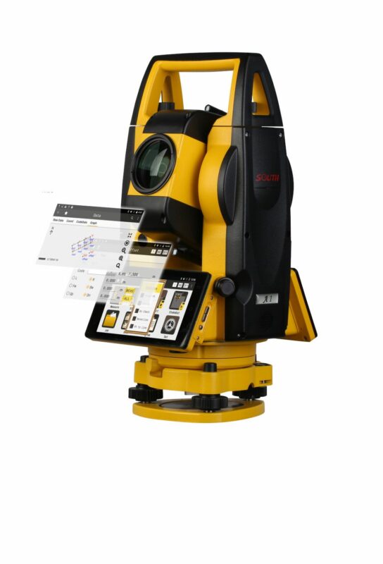
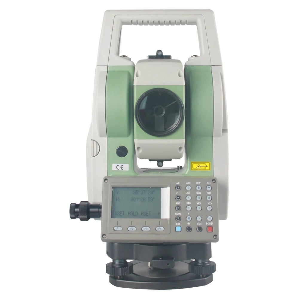
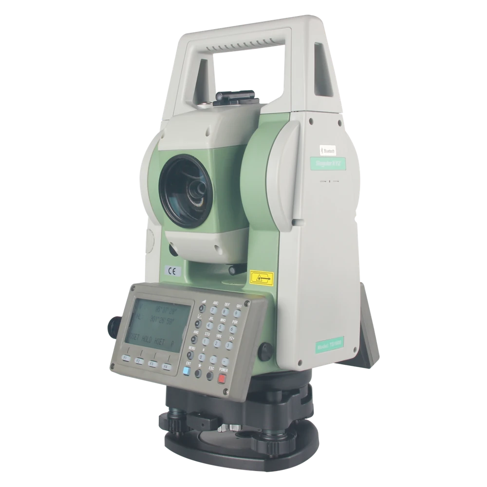
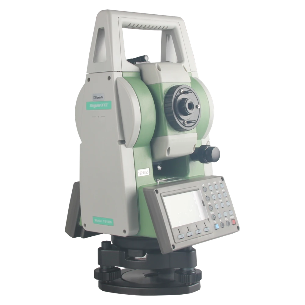
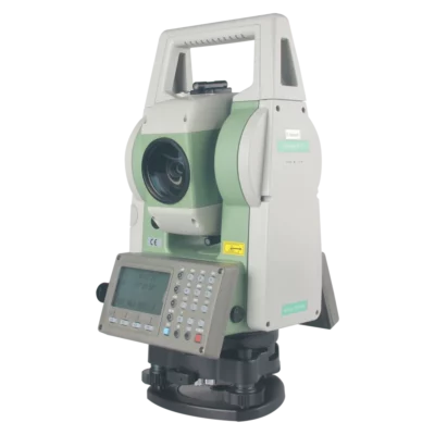
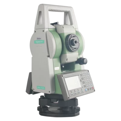
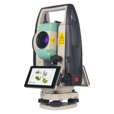
SingularXYZ TS1000 2 Second Total Station with 7500m Prism Range
Get the best price for your setup
Contact our experts for the best possible price and configuration.
- Fast response
- Expert configuration advice
- No overpaying for features you do not need
The SingularXYZ TS1000 is a professional manual total station for land surveying, construction stakeout, topographic mapping and civil engineering. With 2″ angular accuracy, a reflectorless measurement range of up to 1,000 m and a single-prism range of up to 7,500 m, it provides precise optical measurements for everyday surveying and construction work.
Featuring a 30× telescope, dual-sided displays and keyboards, a red laser plummet and Bluetooth connectivity, the TS1000 is designed for straightforward field operation. Integration with SingularPad allows surveyors to perform point measurements, stakeout and CAD-based surveying tasks while managing compatible total station and RTK GNSS data within the same project. Its 40,000-point internal memory, dual-axis compensator and flexible battery options make it a practical instrument for construction teams and professional surveyors.
SingularXYZ TS1000 Highlights
| Angular accuracy | 2″ with selectable 1″ or 5″ readings |
|---|---|
| Reflectorless measurement | Up to 1,000 m; 5 mm + 3 ppm accuracy |
| Prism measurement | Up to 7,500 m; 2 mm + 2 ppm accuracy |
| Telescope | 30× magnification |
| Compensator | Dual-axis with ±3′ working range |
| Displays and controls | Dual 192 × 128 displays with 24-key alphanumeric keyboards |
| Connectivity | Bluetooth, USB and RS232; SingularPad compatible |
| Internal storage | Up to 40,000 points |
| Instrument setup | Integrated red laser plummet |
| Battery life | Up to 6 hours standard; 8 hours with optional lithium battery for angle and distance measurements |
| Weight and protection | 6.5 kg; IP54 |
Valued customers:









Find RTK Networks
Search NTRIP providers and connect to reliable RTK correction services.
Description
SingularXYZ TS1000 Manual Total Station for Professional Surveying
The SingularXYZ TS1000 is a professional manual total station designed for land surveying, construction layout, topographic measurements and civil engineering. Combining 2″ angular accuracy with long-range electronic distance measurement, it allows surveyors to measure coordinates, establish control points and set out construction positions using a familiar optical surveying workflow.
With a reflectorless measuring range of up to 1,000 metres and a single-prism range of up to 7,500 metres, the TS1000 is suitable for both short-distance construction measurements and larger outdoor surveying projects. Its dual-sided displays, integrated laser plummet and Bluetooth connection to SingularPad make it practical for surveyors who need reliable measurements and flexible data collection.
2 Second Angular Accuracy for Surveying and Stakeout
The TS1000 provides angular measurement accuracy of 2 arcseconds, with selectable minimum readings of 1″ or 5″. This allows surveyors to measure horizontal and vertical angles for topographic surveys, construction layout and engineering control networks.
Accurate angular measurements are particularly important when measuring over longer distances, as small angular deviations can result in larger coordinate differences at the target. The instrument combines measured angles with electronic distance measurements to calculate the position of survey points.
For construction workers and land surveyors, this provides a practical method of measuring building corners, ground markers, structural positions and other project features. As with all precision surveying instruments, the final accuracy depends on correct setup, centring, levelling and survey control.
1000 Metre Reflectorless Distance Measurement
The SingularXYZ TS1000 supports reflectorless distance measurements up to 1,000 metres, with specified accuracy of 5 mm + 3 ppm under reference conditions. Reflectorless surveying allows operators to measure suitable visible surfaces without placing a prism directly on the target.
This is useful when measuring building façades, walls, roof structures, retaining walls and other features that are difficult or unsafe to access. For example, a surveyor can aim the telescope at a visible building surface and record the distance from a convenient instrument position.
Reflectorless measurement is also useful for topographic surveys where individual surface points need to be collected without moving a prism pole to every location. Actual measurement range depends on target reflectivity, surface angle, atmospheric conditions and visibility.
7500 Metre Prism Range for Long Distance Measurements
For defined survey points and longer measurements, the TS1000 offers a single-prism range of up to 7,500 metres, with specified distance accuracy of 2 mm + 2 ppm. This makes it suitable for surveying control networks, infrastructure projects and large construction sites with clear optical lines of sight.
Prism measurements are particularly useful when a survey assistant can position a prism pole directly over the point being measured. The total station operator aims at the prism and records the horizontal angle, vertical angle and distance needed to calculate its position.
The TS1000 provides fine, coarse and tracking measurement modes. Fine measurements typically take approximately one second after initial acquisition, while tracking mode updates at approximately 0.3 seconds. Operators can choose the measuring mode according to the precision and speed required for the task.
Bluetooth Integration with SingularPad Software
The TS1000 connects to compatible field controllers through Bluetooth and works with SingularPad surveying software. This allows operators to manage points, coordinates, stakeout tasks and project information through a graphical surveying interface.
SingularPad supports conventional point surveying, construction stakeout, coordinate calculations and CAD-related workflows. Instead of relying only on the total station’s onboard controls, users can work with their project information directly on a compatible controller.
One advantage of SingularPad is its support for both optical surveying and compatible RTK GNSS equipment. A surveyor can establish control points with GNSS in open areas and continue measurements with the TS1000 near buildings, under bridges or in other locations where satellite reception is limited.
Both measurement methods can be managed within the same project and coordinate system when properly configured. The TS1000 itself does not contain a GNSS receiver, so RTK measurements require compatible external GNSS equipment.
Practical Construction Stakeout
Construction stakeout is one of the primary applications of the TS1000. Surveyors can use the instrument to transfer coordinates from a construction drawing to actual positions on the ground, helping site teams locate foundations, building corners, structural grid lines and other important points.
When connected to SingularPad, measured prism positions can be compared with the intended design coordinates. The software can provide positioning information to help the prism operator move towards the required location.
This workflow is useful for building contractors, civil engineers and surveyors working on projects where accurate positioning is essential before excavation, installation or construction begins.
30x Telescope and Dual Axis Compensation
The SingularXYZ TS1000 includes a 30× optical telescope with a 45 mm aperture, 1°30′ field of view and minimum focusing distance of 1.5 metres. The telescope provides clear magnification for aiming at distant prisms, control markers and suitable reflectorless targets.
The instrument also features a dual-axis compensator with a working range of ±3 arcminutes. The compensator helps account for small instrument tilt deviations during measurements, supporting consistent angle observations after the total station has been correctly levelled.
Illuminated telescope crosshairs help operators aim in lower-light environments. The total station is manually operated and does not include motorised robotic prism tracking.
Dual Sided Displays and Easy Instrument Setup
The TS1000 features two 192 × 128 pixel displays with 24-key alphanumeric keyboards. Having controls on both sides of the instrument makes operation more convenient during face-left and face-right measurements, where the telescope is rotated between observation positions.
A built-in red laser plummet assists with positioning the total station over a known ground control point. The plummet provides specified accuracy of 1.5 mm at an instrument height of 1.5 metres under reference conditions.
Combined with the circular and plate levels, the laser plummet helps surveyors prepare accurate instrument setups. This is particularly useful when moving between several stations during a construction or topographic survey.
Flexible Storage and Data Transfer
The TS1000 includes internal storage for up to 40,000 measured points, providing capacity for topographic surveys, construction measurements and other surveying projects.
Data can be transferred using USB, RS232 or Bluetooth connections. External USB storage is also supported, giving users flexibility when moving measurement information between the total station, field controller and office computer.
For companies using SingularPad, recorded measurements can be organised within the software workflow for subsequent processing and integration with other project data.
Battery Options for Fieldwork
The standard TS1000 configuration uses a 2.5 Ah rechargeable Ni-MH battery, providing approximately six hours of combined angle and distance measurements or up to 20 hours of angle-only operation under specified conditions.
An optional 3.2 Ah lithium battery extends combined measurement operation to approximately eight hours, with up to 25 hours of angle-only measurements. This gives surveyors flexibility when choosing a configuration for longer working days.
Actual battery life depends on measurement frequency, operating temperature and the equipment configuration.
Built for Construction and Outdoor Surveying
The SingularXYZ TS1000 weighs approximately 6.5 kg and measures 190 × 210 × 350 mm. Its IP54-rated housing provides protection against dust and splashing water during normal outdoor surveying work.
With an operating temperature range of -20°C to +55°C, the instrument is suitable for various construction and surveying environments. A stable tripod and compatible tribrach are required for accurate operation.
Although the instrument is designed for professional fieldwork, it should be protected from heavy impacts, prolonged rainfall and unstable mounting conditions.
Applications in Land Surveying and Civil Engineering
Topographic and Land Surveys
Land surveyors can use the TS1000 to measure terrain features, ground control points and existing site conditions. Prism measurements are useful for defined positions, while reflectorless measurements allow users to collect coordinates from suitable visible surfaces.
Construction Layout and Stakeout
Construction teams can use the TS1000 to set out foundation corners, building axes, structural grid points and other design positions. SingularPad supports coordinate-based stakeout and helps operators compare measured points with design coordinates.
Roads and Infrastructure
Civil engineering surveyors can use the instrument for control measurements, road construction layout, drainage projects and infrastructure surveys. Its long prism range is useful on larger projects where suitable optical lines of sight are available.
Building and As-Built Surveys
Reflectorless measurement allows surveyors to document visible walls, façades, roof features and structural elements. These measurements can support existing-condition drawings, renovation planning and dimensional checks.
Surveying in GNSS-Restricted Areas
Total stations are useful near tall buildings, under bridges and around structures that obstruct satellite reception. Once suitable survey control has been established, the TS1000 can continue optical coordinate measurements without requiring GNSS reception at each target point.
Engineering Control Surveys
The TS1000 can be used to observe control markers and transfer coordinates between surveying stations. For accuracy-sensitive work, appropriate observation procedures, stable instrument setups and independent verification remain important.
SingularXYZ TS1000 at Global GPS Systems
The SingularXYZ TS1000 is a professional manual total station for surveyors, construction companies and civil engineering teams who need accurate optical measurements and a practical field surveying workflow.
Its combination of 2″ angular accuracy, long-distance prism measurements, reflectorless surveying and SingularPad compatibility makes it suitable for projects that combine traditional total station observations with modern digital surveying.
At Global GPS Systems, we help customers select professional surveying equipment suited to their projects. Contact our team for guidance on the SingularXYZ TS1000, compatible prisms, tripods, field controllers, batteries and SingularPad software configurations.
Specifications
SingularXYZ TS1000 Total Station Specifications
General Specifications
| Manufacturer | SingularXYZ Intelligent Technology Ltd. |
|---|---|
| Brand | SingularXYZ |
| Model | TS1000 |
| Product Name | SingularXYZ TS1000 Total Station |
| Product Type | Manual electronic total station |
| Measurement Functions | Electronic distance measurement, horizontal angle measurement and vertical angle measurement |
| Angular Accuracy | 2″ (0.6 mgon) |
| Maximum Reflectorless Range | 1,000 m |
| Maximum Single-Prism Range | 7,500 m |
| Reflectorless Accuracy | ±(5 mm + 3 ppm) |
| Single-Prism Accuracy | ±(2 mm + 2 ppm) |
| Telescope Magnification | 30× |
| Compensator | Dual-axis, ±3′ |
| Instrument Centring | Integrated red laser plummet |
| Survey Software Integration | SingularPad via Bluetooth |
| Internal Storage | Up to 40,000 survey points |
| Battery Supply | 7.2–7.4 V DC |
| Ingress Protection | IP54 |
| Operating Temperature | -20°C to +55°C |
| Dimensions | 190 × 210 × 350 mm |
| Weight | 6.5 kg |
| Applications | Land surveying, topographic measurement, construction layout, control surveys, cadastral surveying, infrastructure measurement and stakeout |
Electronic Distance Measurement
| Specification | Reflectorless | Single Prism |
|---|---|---|
| Maximum Measuring Range | 1,000 m | 7,500 m |
| Distance Accuracy | ±(5 mm + 3 ppm) | ±(2 mm + 2 ppm) |
| Target Requirement | Suitable reflecting surface | Compatible surveying prism |
| Fine Measurement Time | 1.0 s; first measurement 2.0 s | 1.0 s; first measurement 2.0 s |
| Coarse Measurement Time | 0.7 s; first measurement 2.0 s | 0.7 s; first measurement 2.0 s |
| Tracking Measurement Time | 0.3 s; first measurement 1.5 s | 0.3 s; first measurement 1.5 s |
EDM Measurement Modes and Resolution
| Measurement Mode | Measurement Time | First Measurement | Minimum Reading |
|---|---|---|---|
| Fine | 1.0 s | 2.0 s | 1 mm |
| Coarse | 0.7 s | 2.0 s | 10 mm or 1 mm |
| Tracking | 0.3 s | 1.5 s | 10 mm |
Angle Measurement
| Angular Accuracy | 2″ |
|---|---|
| Angular Accuracy in Milligons | 0.6 mgon |
| Selectable Minimum Reading | 1″ or 5″ |
| Minimum Reading in Milligons | 0.2 mgon or 1 mgon |
| Angle Measurement Time | 0.1 s |
| Horizontal Angles | Supported |
| Vertical Angles | Supported |
| Automatic Tilt Compensation | Supported |
| Accuracy Qualification | Angular accuracy and minimum displayed reading are different specifications. |
Telescope and Optical System
| Telescope Type | Optical surveying telescope |
|---|---|
| Magnification | 30× |
| Objective Aperture | 45 mm |
| Field of View | 1°30′ |
| Minimum Focusing Distance | 1.5 m |
| Image Orientation | Erect |
| Reticle Illumination | Supported |
| Target Aiming | Manual optical aiming |
| Robotic Target Tracking | Not specified; manual total station configuration |
Dual-Axis Compensator
| Compensator Type | Dual-axis |
|---|---|
| Compensation Range | ±3′ |
| Compensation Range in Degrees | ±0.05° |
| Correction Unit | 1″ |
| Automatic Tilt Correction | Supported within the compensator range |
| Levelling Requirement | The instrument must be levelled within the permitted compensation range. |
Levelling and Centring
| Circular Level | Integrated |
|---|---|
| Circular Level Sensitivity | 8′ / 2 mm |
| Plate Level | Integrated |
| Plate Level Sensitivity | 30″ / 2 mm |
| Plummet Type | Red laser |
| Plummet Centring Accuracy | 1.5 mm at an instrument height of 1.5 m |
| Plummet Reference Height | 1.5 m |
| Laser Wavelength | Not specified in the manufacturer datasheet |
| Laser Safety Classification | Not specified in the manufacturer datasheet |
Display and Keyboard
| Display Configuration | Dual-side |
|---|---|
| Display Resolution | 192 × 128 pixels |
| Keyboard | Alphanumeric |
| Keyboard Keys | 24 |
| Dual-Side Instrument Operation | Supported |
| Touchscreen | Not specified |
| Display Size | Not specified |
Storage and Communication
| Internal Storage | Up to 40,000 survey points |
|---|---|
| External USB Storage | Supported |
| RS232 Serial Communication | Supported |
| Bluetooth Communication | Supported |
| USB Communication | Supported |
| Bluetooth Field Controller Connection | Supported with compatible equipment |
| Survey Data Transfer | Via RS232, Bluetooth or USB |
| External Software Project Storage | Supported through SingularPad |
| Bluetooth Version | Not specified |
| USB Version | Not specified |
| Wi-Fi | Not specified as an integrated interface |
| Integrated GNSS Receiver | No; GNSS measurements require separate GNSS equipment |
Battery Configuration Comparison
| Specification | Standard Battery | Optional Battery |
|---|---|---|
| Battery Type | Nickel-metal hydride (Ni-MH) | Lithium |
| Capacity | 2.5 Ah (2,500 mAh) | 3.2 Ah (3,200 mAh) |
| Instrument Supply Voltage | 7.2–7.4 V DC | 7.2–7.4 V DC |
| Distance and Angle Measurement Runtime | 6 hours | 8 hours |
| Angle-Only Measurement Runtime | 20 hours | 25 hours |
| Configuration | Standard | Optional upgrade |
Electrical Specifications
| Instrument Supply Voltage | 7.2–7.4 V DC |
|---|---|
| Standard Battery Capacity | 2.5 Ah |
| Optional Lithium Battery Capacity | 3.2 Ah |
| Battery Operating Time Reference | One battery |
| Charging Time | Not specified in the manufacturer datasheet |
| Charging Equipment Rating | Not specified in the manufacturer datasheet |
| Power Consumption | Not specified in the manufacturer datasheet |
| Battery Runtime Qualification | Operating time depends on battery condition, temperature and the measurement mode used. |
Physical and Mechanical Specifications
| Instrument Type | Manual total station |
|---|---|
| Overall Dimensions | 190 × 210 × 350 mm |
| Length | 190 mm |
| Width | 210 mm |
| Height | 350 mm |
| Weight | 6.5 kg |
| Optical Telescope | 30× magnification |
| Display Arrangement | Dual-side |
| Instrument Controls | 24-key alphanumeric keyboard |
| Laser Centring | Integrated red laser plummet |
| Instrument Levelling | Circular level, plate level and dual-axis compensator |
| Survey Tripod Compatibility | Compatible total station tripod and mounting assembly required |
Environmental Specifications
| Operating Temperature | -20°C to +55°C |
|---|---|
| Storage Temperature | -40°C to +60°C |
| Ingress Protection Rating | IP54 |
| Dust Protection | IP5X — dust-protected |
| Water Protection | IPX4 — protection against splashing water |
| Operating Humidity | Not specified in the manufacturer datasheet |
| Impact Protection | Not specified in the manufacturer datasheet |
| Water Resistance Note | IP54 does not indicate protection against submersion or high-pressure water exposure. |
Survey Software and Workflow Compatibility
| Compatible Field Software | SingularPad |
|---|---|
| Connection | Bluetooth |
| Point Surveying | Supported |
| Point Stakeout | Supported |
| Real-Time Stakeout Position Sharing | Supported through compatible SingularPad workflows |
| CAD-Related Survey Functions | Available through compatible SingularPad features |
| Survey Project Storage | Supported |
| Survey Data Transfer | Supported |
| GNSS and Optical Surveying in One Project | Supported through SingularPad when a separate compatible GNSS receiver is used |
| Shared Coordinate Reference System | Supported through SingularPad project configuration |
| GNSS Requirement | External GNSS receiver required for satellite positioning workflows |
| Software Feature Availability | Depends on the SingularPad version, controller configuration and compatible surveying equipment. |
Surveying Applications
| Land Surveying | Angle and distance measurement for survey control and detail points |
|---|---|
| Topographic Surveying | Terrain and site feature measurement |
| Construction Layout | Building and infrastructure setting out |
| Point Stakeout | Positioning design coordinates in the field |
| Building Axis Setting Out | Measurement and layout of construction grid lines |
| Foundation Surveying | Setting out construction reference points and foundations |
| Boundary Surveying | Parcel boundary and cadastral measurement |
| Survey Control Networks | Angle and distance observations for control surveys |
| Infrastructure Measurement | Road, bridge, utility and structural surveying |
| As-Built Documentation | Measurement of constructed elements and their positions |
| Prism Surveying | Long-range point measurement with compatible single prism |
| Reflectorless Surveying | Direct measurement to suitable surfaces without positioning a prism |
Manufacturer-Documented Package Contents
| Item | Quantity | Notes |
|---|---|---|
| SingularXYZ TS1000 Total Station | 1 | Main electronic surveying instrument |
| Rechargeable Batteries | 2 | Standard 2.5 Ah Ni-MH battery specification; optional 3.2 Ah lithium configuration |
| Battery Charger | 1 | For the supplied battery configuration |
| USB Flash Disk | 1 | For data transfer |
| Carrying Straps | 2 | Transport accessories |
| Dust Cover | 1 | Instrument protection |
| Transport Case | 1 | Instrument storage and transport |
| Reflective Target | Listed | Quantity not clearly specified in the manufacturer packing list |
| Small Tool Bag | 1 | Contains a screwdriver, lens cloth and small cleaning or maintenance tool |
| Survey Tripod | Not confirmed | Confirm whether supplied separately |
| Survey Prism Set | Not confirmed | Separate from the reflective target; verify the selected package |
| SingularPad Controller and Software | Configuration-dependent | Confirm inclusion, compatibility and licence |
Manufacturer Documentation and Specification Notes
| Product Page | Global GPS Systems – SingularXYZ TS1000 |
|---|---|
| Supplier-Hosted Datasheet | TS1000 Total Station Datasheet (PDF) |
| Official Manufacturer Product Page | SingularXYZ TS1000 Total Station |
| Official Manufacturer Datasheet | SingularXYZ TS1000 Technical Datasheet (PDF) |
| Manufacturer Packing List | SingularXYZ TS1000 User Documentation and Packing List |
| Datasheet Version | 17-08-2022 |
| Reflectorless Accuracy Qualification | The manufacturer specifies ±(5 mm + 3 ppm) for non-prism measurement. |
| Prism Accuracy Qualification | The manufacturer specifies ±(2 mm + 2 ppm) with a single prism. |
| Range Qualification | The maximum published ranges are 1,000 m reflectorless and 7,500 m with a single prism, subject to measurement conditions. |
| Angular Measurement Qualification | 2″ is the specified angle accuracy; 1″ and 5″ are selectable minimum readings. |
| Battery Configuration Qualification | The standard battery is 2.5 Ah Ni-MH. The optional lithium battery has a 3.2 Ah capacity and different published operating times. |
| GNSS Compatibility Qualification | The TS1000 is an optical total station without an integrated GNSS receiver. GNSS/RTK functions in SingularPad require a separate compatible GNSS instrument. |
| Package Contents Qualification | Manufacturer packing-list quantities are provided for the documented configuration. Actual supplied accessories must be confirmed with the current package. |
Specifications and package contents may vary by configuration, region or manufacturer update. Always check the current configuration before ordering.
Reviews (0)
Only logged in customers who have purchased this product may leave a review.
FAQ
SingularXYZ TS1000 Total Station FAQ
General Information and Key Features
What is the SingularXYZ TS1000 Total Station?
The SingularXYZ TS1000 is a professional manual total station designed for precise land surveying, topographic mapping, construction stakeout and civil engineering measurements. It combines electronic distance measurement (EDM), 2-second angular accuracy, a 30x optical telescope and dual-sided displays. The TS1000 supports reflectorless measurements up to 1,000 meters and single-prism measurements up to 7,500 meters. It also features Bluetooth connectivity, compatibility with SingularPad surveying software, internal storage for 40,000 survey points and a built-in red laser plummet.
What are the main features of the SingularXYZ TS1000?
The SingularXYZ TS1000 features 2-second angular accuracy, reflectorless distance measurement up to 1,000 meters and single-prism measurement up to 7,500 meters. It includes a 30x magnification telescope, dual-axis tilt compensator, red laser plummet, dual-sided displays and 24-key alphanumeric keyboards. Additional features include Bluetooth, USB and RS232 connectivity, internal storage for up to 40,000 points, compatibility with SingularPad field surveying software and IP54 environmental protection. The standard rechargeable battery provides approximately 6 hours of combined angle and distance measurement.
How accurate is the SingularXYZ TS1000 Total Station?
The SingularXYZ TS1000 provides an angular measurement accuracy of 2 arcseconds (2"). Its electronic distance measurement system offers a specified accuracy of 2 mm + 2 ppm when measuring with a single prism and 5 mm + 3 ppm in reflectorless mode. These specifications make the instrument suitable for professional land surveying, construction layout and engineering measurements. Actual accuracy depends on atmospheric conditions, instrument setup, target characteristics, measurement distance and surveying procedures.
What is the maximum measuring range of the SingularXYZ TS1000?
The SingularXYZ TS1000 supports reflectorless distance measurement up to 1,000 meters and single-prism measurement up to 7,500 meters. Reflectorless mode allows surveyors to measure suitable objects and surfaces without placing a prism at the target location. Prism measurement is particularly useful for long-distance surveying, control networks and construction stakeout. Actual measuring range depends on atmospheric visibility, target reflectivity, prism condition and environmental conditions.
What is the difference between reflectorless and prism measurement on the TS1000?
Reflectorless measurement allows the SingularXYZ TS1000 to measure distances directly to suitable surfaces without requiring a surveying prism. It supports distances up to 1,000 meters with a specified accuracy of 5 mm + 3 ppm. Prism measurement uses a reflector positioned at the target and provides higher specified accuracy of 2 mm + 2 ppm over distances up to 7,500 meters. Reflectorless mode is useful for inaccessible surfaces and building measurements, while prism mode is commonly preferred for longer distances and precise survey control.
Is the SingularXYZ TS1000 a manual or robotic total station?
The SingularXYZ TS1000 is a manual total station. Operators aim the telescope, identify the surveying target and perform measurements using the instrument controls or compatible field surveying software. The TS1000 does not include motorized rotation, automatic prism tracking or robotic target-following capabilities. It is designed for conventional optical surveying applications where accurate measurement, straightforward operation and digital data management are required.
Applications and Professional Surveying
What industries and professionals use the SingularXYZ TS1000?
The SingularXYZ TS1000 is designed for land surveyors, construction surveyors, civil engineers, cadastral surveyors, infrastructure contractors and geospatial professionals. Typical applications include topographic surveying, construction layout, property boundary measurement, control point surveying, road engineering and infrastructure documentation. Its combination of long-distance electronic distance measurement, precise angular measurement and SingularPad compatibility makes it suitable for professionals working with coordinate-based surveying and construction projects.
Can the SingularXYZ TS1000 be used for topographic and land surveying?
Yes. The SingularXYZ TS1000 is suitable for topographic surveying, land measurement and terrain mapping. It measures horizontal angles, vertical angles and distances, allowing surveyors to calculate the coordinates and elevations of survey points. These measurements can be used to document terrain features, buildings, roads, property boundaries and existing infrastructure. When connected to SingularPad software, the TS1000 supports point surveying, coordinate management and other digital field measurement workflows.
Is the SingularXYZ TS1000 suitable for construction stakeout and building layout?
Yes. The SingularXYZ TS1000 supports construction stakeout, building layout and engineering positioning using its optical measurement system and compatible SingularPad software. Surveyors can set out design coordinates for foundations, structural grid lines, building corners, columns, walls and other construction elements. SingularPad supports point stakeout, CAD-related workflows and coordinate calculations. Reliable construction stakeout requires correct station setup, instrument orientation, project coordinates and appropriate surveying procedures.
Can the SingularXYZ TS1000 be used for cadastral and property boundary surveying?
Yes. The SingularXYZ TS1000 can be used to measure boundary markers, property corners, distances, angles and survey control points during cadastral and land subdivision projects. Its prism and reflectorless measurement capabilities provide flexibility for different field conditions. Collected coordinates can be managed using compatible surveying software. Legal property boundary determination must follow applicable cadastral regulations, official records and local surveying standards.
Can the SingularXYZ TS1000 be used for road construction and civil engineering?
Yes. The SingularXYZ TS1000 is suitable for road construction, drainage projects, utility installations and civil infrastructure surveying. It can be used to establish survey control, measure existing terrain, set out design positions and verify construction geometry. When connected to SingularPad, surveyors can perform coordinate calculations and supported construction stakeout workflows. Its long single-prism measurement range is particularly useful for projects involving large construction sites and extended sight lines.
Can the SingularXYZ TS1000 operate without GPS or GNSS signals?
Yes. The SingularXYZ TS1000 uses optical angle measurement and electronic distance measurement rather than satellite positioning. It can therefore operate where GNSS reception is obstructed or unavailable, including near tall buildings, beneath bridges and inside suitable structures. The instrument requires a clear line of sight to the measured target and a properly established survey station. Known control points or an appropriate local coordinate system are required when measurements must be connected to project coordinates.
Technical Specifications and Hardware
What telescope magnification does the SingularXYZ TS1000 have?
The SingularXYZ TS1000 features a 30x optical telescope with a 45 mm aperture, a field of view of 1 degree 30 minutes and a minimum focusing distance of 1.5 meters. The telescope provides an upright image and supports reticle illumination. Its optical specifications are suitable for identifying surveying prisms, targeting distant objects and performing precise manual observations during land surveying and construction layout.
Does the SingularXYZ TS1000 have a dual-axis compensator?
Yes. The SingularXYZ TS1000 includes a dual-axis tilt compensator with a working range of ±3 arcminutes and a correction resolution of 1 arcsecond. The compensator helps correct small instrument tilts during angle measurement and contributes to reliable surveying results. A stable tripod, correct centering and accurate initial leveling remain essential because the compensator cannot correct large setup errors or unstable instrument positioning.
Does the SingularXYZ TS1000 include a laser plummet?
Yes. The SingularXYZ TS1000 features a built-in red laser plummet for centering the instrument over a survey station or ground control point. The manufacturer specifies a centering accuracy of approximately 1.5 mm at an instrument height of 1.5 meters. The visible laser simplifies instrument setup and helps operators align the total station with the ground mark. Accurate centering is especially important for control surveying and construction stakeout.
How fast does the SingularXYZ TS1000 measure distances and angles?
The SingularXYZ TS1000 offers several electronic distance measurement modes. Fine measurement takes approximately 1.0 second after initialization, coarse measurement takes approximately 0.7 seconds and tracking mode takes approximately 0.3 seconds. The first measurement may take longer, depending on the selected mode. Angular measurement takes approximately 0.1 seconds. Tracking mode is useful during stakeout, while fine measurement is suitable for precise survey observations.
What displays and keyboards does the SingularXYZ TS1000 have?
The SingularXYZ TS1000 features displays and alphanumeric keyboards on both sides of the instrument. Each display has a resolution of 192 × 128 pixels, while each keyboard provides 24 keys for instrument operation and data entry. The dual-sided configuration allows surveyors to control the instrument and review measurement information from either telescope position. This is particularly useful when performing face-left and face-right observations during conventional surveying.
How much does the SingularXYZ TS1000 weigh and what are its dimensions?
The SingularXYZ TS1000 weighs approximately 6.5 kg and measures 190 × 210 × 350 mm. Its housing integrates the optical telescope, electronic distance measurement system, dual-axis compensator, laser plummet, displays and communication interfaces. A complete surveying setup also requires appropriate accessories, such as a tripod and any necessary surveying prisms or prism poles. The total carrying weight depends on the accessories used.
What are the battery life and environmental protection specifications of the TS1000?
The SingularXYZ TS1000 uses a rechargeable 7.2 to 7.4 V battery. The standard 2.5 Ah Ni-MH battery provides approximately 6 hours of combined angle and distance measurement or up to 20 hours of angle-only operation. An optional 3.2 Ah lithium battery extends these figures to approximately 8 and 25 hours respectively. The instrument has IP54 ingress protection and an operating temperature range of -20°C to +55°C. IP54 provides protection against limited dust ingress and splashing water but does not make the instrument waterproof or suitable for immersion.
Software, Connectivity and Surveying Workflow
Which surveying software is compatible with the SingularXYZ TS1000?
The SingularXYZ TS1000 is compatible with SingularPad field surveying software. SingularPad supports point surveying, coordinate management, construction stakeout, CAD-related workflows and surveying calculations. The TS1000 connects to a compatible field controller through Bluetooth, allowing measurements to be collected and managed within a digital surveying project. SingularPad also supports compatible GNSS receivers, enabling optical and GNSS surveying workflows to be managed using the same project and coordinate reference system.
Can the SingularXYZ TS1000 work together with an RTK GNSS receiver?
Yes. The SingularXYZ TS1000 can be used alongside compatible RTK GNSS receivers through SingularPad surveying software. Optical total station measurements and GNSS survey points can be managed within the same project and coordinate reference system. Surveyors can use GNSS for locations with suitable satellite reception and the total station for measurements where GNSS reception is obstructed or optical measurement is preferred. The TS1000 itself does not contain an integrated GNSS receiver.
Does the SingularXYZ TS1000 support Bluetooth, USB and RS232 connectivity?
Yes. The SingularXYZ TS1000 supports Bluetooth, USB and RS232 serial communication. Bluetooth allows wireless connection to compatible field controllers running SingularPad software. USB supports data transfer and external storage expansion, while RS232 provides serial communication with compatible external equipment. These connectivity options allow surveyors to integrate the instrument into different field measurement and data management workflows.
How many survey points can the SingularXYZ TS1000 store?
The SingularXYZ TS1000 provides internal storage for up to 40,000 survey points. The instrument also supports external USB storage and additional data management through compatible field surveying software. This allows surveyors to collect and organize measurements from large projects and transfer the information for further processing. Regular data transfer and backup are recommended to protect important survey records.
Can the SingularXYZ TS1000 be used for CAD-based stakeout?
Yes. When connected to SingularPad field surveying software, the SingularXYZ TS1000 supports CAD-related surveying and construction stakeout workflows. Surveyors can use design coordinates, point databases and compatible drawing information to locate planned construction positions in the field. SingularPad provides point surveying, stakeout and coordinate calculation tools. Available CAD import and stakeout functions depend on the installed software version and project configuration.
Can prism operators receive real-time stakeout information from the TS1000?
Yes. SingularXYZ identifies support for sharing real-time stakeout positions with prism operators through SingularPad surveying software. This can improve communication between the total station operator and the person carrying the prism during construction layout. The workflow relies on compatible controllers, software and communication connections. Available functionality depends on the SingularPad version and connected equipment.
What is the difference between the SingularXYZ TS1000 and STS2 Total Stations?
Both the SingularXYZ TS1000 and STS2 are manual total stations featuring 2-second angular accuracy, 30x telescope magnification and reflectorless measurement up to 1,000 meters. The TS1000 offers a longer single-prism measurement range of 7,500 meters, compared with 5,000 meters for the STS2. It also provides internal storage for 40,000 survey points, compared with 16,000 points for the STS2. Both support SingularPad surveying workflows, although their onboard interfaces, hardware specifications and battery configurations differ. The TS1000 is particularly suitable when long prism measurement distances and larger onboard point storage are important.
 GPS & GNSS
 Total Stations
 Data collectors
 Software
 Correction services
 Machine control
 External radio
 Marine
 Accessories
Reviews
There are no reviews yet