

GNSS
GNSS vs GPS Accuracy: Why RTK Correction Matters for Centimetre Precision
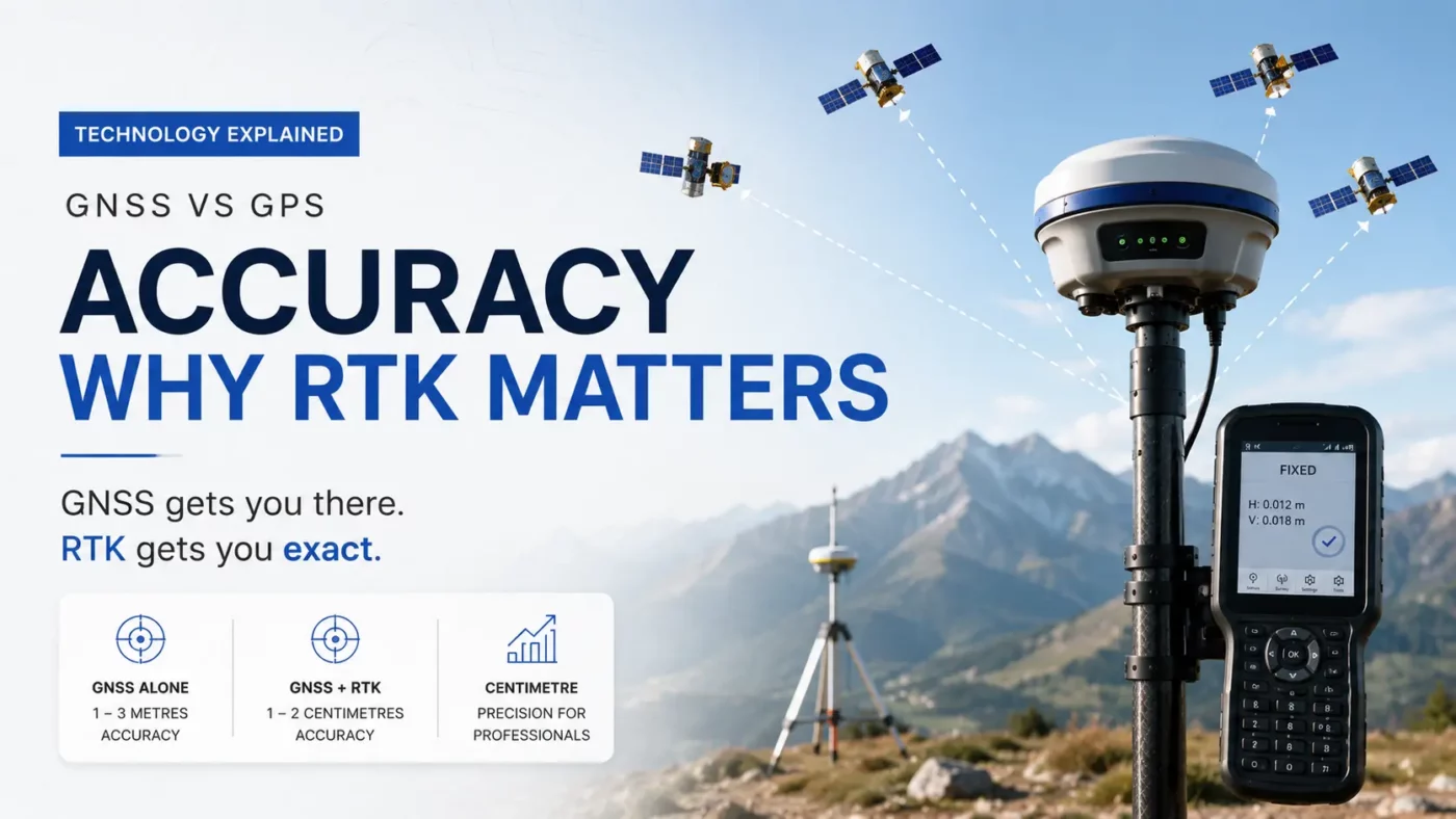
Many people assume that modern GNSS technology automatically delivers centimetre-level positioning accuracy. In reality, even advanced GNSS receivers are usually accurate to within 1 to 3 metres when operating without correction data. While this is a major improvement over older GPS-only systems, it is still not precise enough for professional surveying, construction, machine control, or precision agriculture.
To achieve true survey-grade positioning, GNSS receivers require RTK correction technology. At Global GPS Systems, we provide professional RTK GNSS solutions for surveyors, construction professionals, GIS specialists, and agricultural users who need reliable centimetre-level accuracy in the field.
What Is the Difference Between GPS and GNSS?
GPS is often used as a general term for satellite positioning, but technically GPS is only one satellite constellation operated by the United States. GNSS stands for Global Navigation Satellite System and refers to the combined use of multiple satellite constellations, including:
- GPS (United States)
- GLONASS (Russia)
- Galileo (Europe)
- BeiDou (China)
Modern GNSS receivers use signals from multiple constellations simultaneously. This improves satellite availability, positioning reliability, and overall accuracy, especially in challenging environments such as urban areas, forests, and construction sites. However, even with multi-constellation support, standalone GNSS positioning is typically limited to metre-level accuracy without correction services.
Why Standard GNSS Is Not Centimetre Accurate
A GNSS receiver calculates its position using signals transmitted by satellites orbiting the Earth. Although the technology is highly advanced, several unavoidable factors introduce positioning errors.
These errors include atmospheric disturbances, satellite orbit deviations, signal reflections from nearby objects, satellite clock inaccuracies, and poor satellite geometry. Even high-end GNSS receivers cannot fully eliminate these errors on their own. As a result, standalone GNSS positioning generally achieves accuracy between 1 and 3 metres under normal conditions. For navigation applications this is more than sufficient, but industries such as surveying, engineering, and construction require far greater precision.
What Is RTK?
RTK stands for Real-Time Kinematic positioning. RTK is a correction technology that dramatically improves GNSS accuracy by correcting satellite signal errors in real time. An RTK system consists of two main components:
- A reference (base) station or RTK network
- A GNSS rover receiver
The reference station operates from a precisely known location. Because its exact position is fixed, it can continuously calculate the errors affecting incoming satellite signals. These corrections are then transmitted to the rover receiver through the internet, radio, or cellular network. Once the rover applies these corrections, positioning accuracy improves from metre-level accuracy to centimetre-level precision. Under ideal conditions, RTK GNSS systems commonly achieve horizontal accuracy of 1 to 2 centimetres.
Why RTK GNSS Is Essential for Surveying and Construction
Professional industries depend on RTK GNSS because even small positioning errors can create costly problems. Surveyors use RTK GNSS receivers for boundary measurements, topographic surveys, stakeout work, and infrastructure mapping. Construction companies rely on RTK positioning for machine control, excavation guidance, grading, and site layout.
Agriculture is another major sector where RTK GNSS has become essential. Precision farming systems use RTK corrections to guide tractors and agricultural machinery with extreme accuracy, reducing overlap, lowering fuel consumption, and improving efficiency. For these applications, standard GNSS simply does not provide enough precision without correction technology.
Network RTK and Modern Correction Services
Modern RTK workflows no longer require every user to operate their own physical base station. Today, many professionals use Network RTK services that provide correction data through mobile internet connections. These services use multiple permanent reference stations to generate highly accurate correction information across large geographic regions.
One example is RTK FIX, a professional RTK correction marketplace platform that provides reliable RTK network access from multiple ntrip providers for surveyors, construction professionals, and precision agriculture users. RTKFIX enables compatible GNSS receivers to receive real-time correction data over the internet, allowing users to achieve centimetre-level positioning without maintaining their own base station infrastructure. You can learn more about professional RTK correction services at:

For users investing in professional GNSS equipment, combining a modern RTK receiver with a reliable correction service is the key to achieving maximum positioning performance.
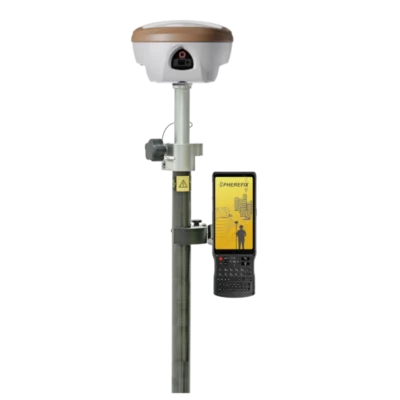
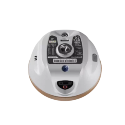
Choosing the Right RTK GNSS Receiver
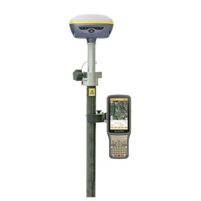
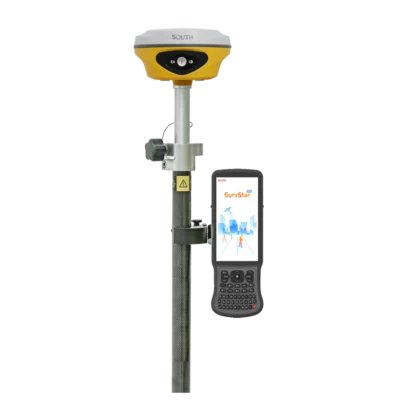
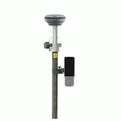
Not all GNSS receivers are designed for high-precision RTK applications. Professional users should look for multi-frequency, multi-constellation RTK receivers that support modern correction protocols and reliable field performance. Global GPS Systems offers professional RTK-enabled GNSS receivers for surveying, construction, and GIS applications.
GPS & GNSS


GPS & GNSS
GPS & GNSS
These receivers are designed to work with modern RTK correction networks and provide reliable centimetre-level positioning in demanding environments.
GNSS vs GPS vs RTK Explained Simply
The easiest way to understand the difference is: GPS is one satellite system. GNSS combines multiple satellite systems. RTK is the correction technology that transforms GNSS from metre-level positioning into centimetre-level accuracy. Without RTK corrections, even advanced GNSS receivers cannot consistently achieve survey-grade precision.
Final Thoughts
GNSS technology has significantly improved modern positioning by combining multiple global satellite constellations into one integrated system. Compared to traditional GPS-only receivers, GNSS provides better coverage, stronger
reliability, and improved positioning performance. However, standalone GNSS is still generally limited to metre-level accuracy. For professional applications requiring true centimetre precision, RTK correction technology remains essential. By combining a professional RTK GNSS receiver with a reliable correction platform such as RTKFIX, users can achieve the accuracy required for surveying, construction, precision agriculture, machine control, and advanced geospatial workflows.