

 GPS & GNSS
 Lidar scanning
 Total Station


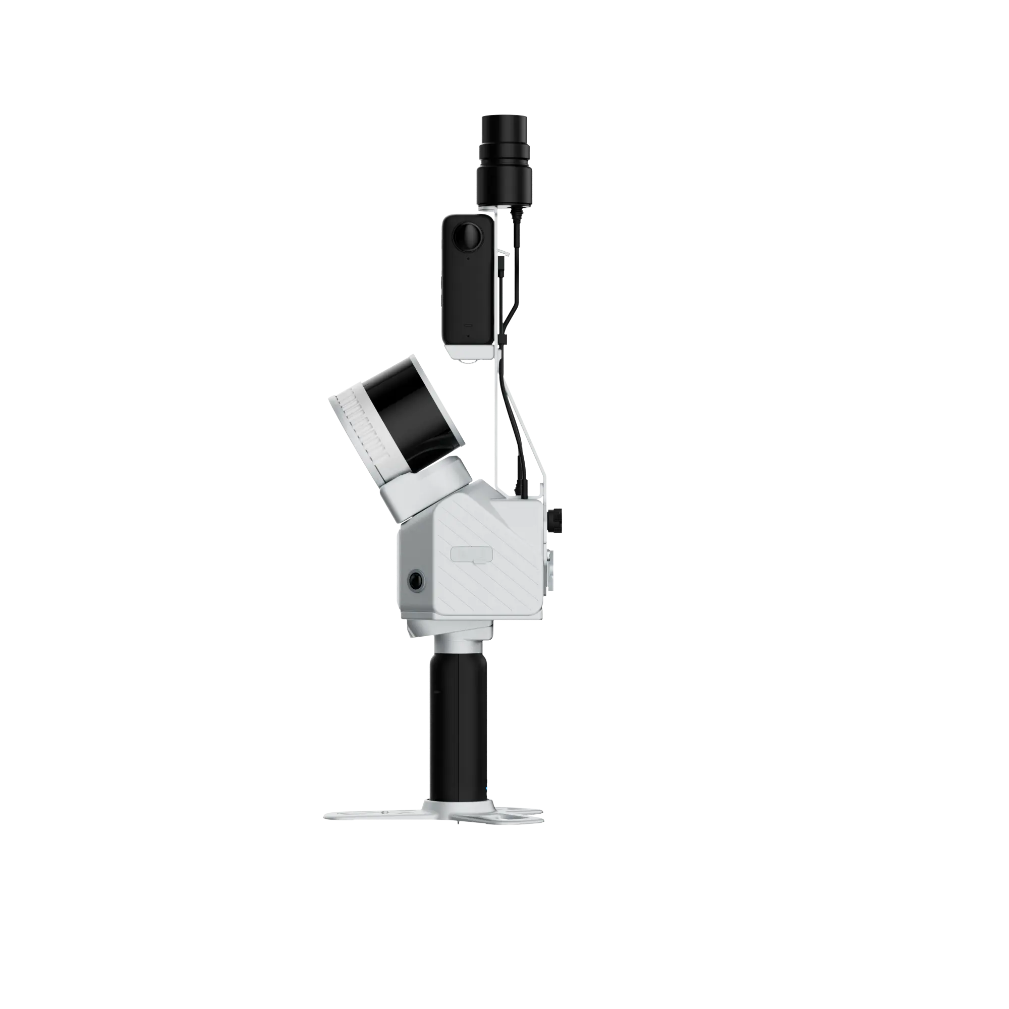


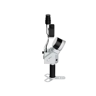


FJ Dynamics Trion S2
Get the best price for your setup
Contact our experts for the best possible price and configuration.
- Fast response
- Expert configuration advice
- No overpaying for features you do not need
The FJD Trion S2 Series LiDAR Scanner is a compact, professional 3D scanning solution for surveyors, construction teams, engineers, forestry specialists, mining operators and mapping professionals who need fast, colourised and georeferenced point cloud data in the field. With integrated GNSS, IMU, dual 12 MP cameras, VIO and LiDAR SLAM, the S2 Series is designed for flexible reality capture across open sites, complex terrain, indoor-outdoor environments and hard-to-access areas.
| Available models | S2, S2 PRO, S2 MAX |
|---|---|
| Relative accuracy | Up to ≤ 1 cm* |
| Range | Up to 120 m, or up to 300 m with S2 MAX at 80% reflectivity |
| Point rate | 320,000 pts/s or 640,000 pts/s depending on model |
| Runtime | 3 hours with 1 set of 2 batteries |
| Point cloud formats | .las, .ply, .pts, .e57 |
The FJD Trion S2 stands out by combining LiDAR, GNSS, cameras, IMU, real-time colourised point cloud viewing and the FJD Trion software ecosystem in one mobile scanning workflow. This makes it suitable for users who want faster field capture, fewer revisits and deliverables that can move into CAD, BIM, GIS, mapping and inspection workflows.
*Accuracy measured in an experimental environment according to the brochure.
Valued customers:










Find RTK Networks
Search NTRIP providers and connect to reliable RTK correction services.
Description
FJD Trion S2 Series LiDAR Scanner
The FJD Trion S2 Series LiDAR Scanner is a professional mobile LiDAR scanning system designed for fast 3D data capture in surveying, construction, mining, forestry, infrastructure inspection, property management and incident documentation. It combines LiDAR scanning, integrated GNSS, a high-precision IMU, dual fisheye cameras, VIO and LiDAR SLAM into a compact field-ready solution.
For field teams, the main advantage is workflow efficiency. The S2 Series helps capture colourised, georeferenced point clouds while the operator moves through the site. Instead of relying only on static scanning positions or conventional measurement methods, users can collect large areas, complex spaces and difficult terrain with a flexible handheld or mounted setup.

Key Advantages
- Compact mobile LiDAR scanner for professional 3D reality capture.
- Available in S2, S2 PRO and S2 MAX configurations.
- Up to ≤ 1 cm relative accuracy in experimental conditions.
- Integrated GNSS, IMU, dual 12 MP cameras, VIO and LiDAR SLAM.
- Real-time colourised point cloud visualisation with FJD Trion Scan.
- Supports georeferenced point cloud workflows and over 8,000 coordinate systems.
- Flexible deployment with handheld, vehicle, drone, backpack, extension pole and other mounting options.
- Compatible with FJD Trion Scan, FJD Trion Model, FJD Trion Model for Pad, Model Web and FJD Trion Cloud workflows.
Built for Fast Field Capture
The FJD Trion S2 Series is designed to start quickly and move smoothly between field tasks. The integrated design brings the camera, IMU and GNSS module together in one system, helping teams reduce setup time and maintain productivity during fieldwork.
Depending on the model, the S2 Series offers either 16 or 32 LiDAR channels and point output of up to 320,000 or 640,000 points per second. This allows users to select the version that best fits the required scan detail, working distance and project type. For general large-site capture, the S2 offers balanced performance, while the S2 PRO and S2 MAX provide higher point output. The S2 MAX also extends the range to 300 m at 80% reflectivity.
Reliable Colourised Point Clouds
The scanner uses dual 12 MP fisheye cameras for real-time colourisation. In practical terms, this helps make point clouds easier to interpret because visual context is available directly in the scan data. This can be useful for building documentation, site inspections, asset records, forestry analysis, construction monitoring and digital twin workflows.
Advanced VIO and LiDAR SLAM help the scanner maintain stable performance while moving through complex spaces. This is especially valuable in environments where GNSS alone is limited, such as urban corridors, forests, tunnels, indoor-outdoor transition zones and construction sites with obstructions.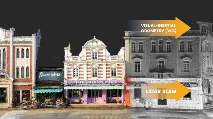
Georeferenced Mapping and GIS Integration
With integrated GNSS and support for more than 8,000 coordinate systems, the FJD Trion S2 Series fits into professional GIS, mapping and surveying workflows. Starting in the correct coordinate system helps reduce manual conversion work and can make the transition from field data to deliverables more efficient.
The system supports RTK accuracy specifications of 8 mm + 1 ppm RMS horizontally and 15 mm + 1 ppm RMS vertically. For surveying and mapping users, this supports workflows where point cloud data needs to be connected to project coordinates, control points or local geospatial reference systems.
Flexible Deployment Options
The FJD Trion S2 Series can be used in multiple field configurations. The brochure lists deployment and accessory options including car mount, drone mount, quick extension pole, robot dog mount, backpack, stabilising vest and rolling suitcase. This flexibility makes the system suitable for open construction sites, elevated areas, hard-to-access spaces, long corridors, forested areas and larger mapping projects.
For operators, the practical benefit is adaptability. A handheld setup can be used for fast walkthroughs, a vehicle setup can cover larger sites more efficiently, and a drone or elevated mounting option can help capture perspectives that are difficult to reach from the ground.
FJD Trion Software Ecosystem
The S2 Series is designed to work with the FJD Trion ecosystem from capture to processing and collaboration. FJD Trion Scan supports continuous site capture, real-time colourised point cloud viewing, coverage checks, scan sessions of up to 1 hour and resume-from-breakpoint functionality.
For processing and deliverables, FJD Trion Model and FJD Trion Model for Pad support field review and point cloud processing. FJD Trion Cloud and FJD Trion Model Web support sharing, review and collaboration, helping teams work with scan data without being limited to one device or local storage workflow.
Deliverables from One Scan
The S2 Series is suitable for more than just raw point cloud capture. The brochure describes workflows for point clouds, 2D floor plans, 3D mesh models, 3D Gaussian Splatting and georeferenced panoramas. This makes the scanner relevant for survey deliverables, CAD and BIM preparation, engineering documentation, facility records, property management and immersive visualisation.
| Deliverable | Practical use |
|---|---|
| Point clouds | Dense reality data for CAD, BIM, inspection, measurement and analysis workflows. |
| 2D floor plans | Automatically vectorised sections for engineering design and documentation. |
| 3D mesh models | Photorealistic textured models for visualisation, AR/VR and project records. |
| 3D Gaussian Splatting | Immersive scene reconstruction and visualisation. |
| Georeferenced panoramas | Context-rich site records for facility management, property management and inspection. |
HyperDense+ Enhanced Detail
When processed in FJD Trion Model, HyperDense+ can generate 5–7 times denser point clouds with up to 1 mm spacing. This can help improve fine surface detail and colourisation for users who need more detailed scan outputs for documentation, modelling or analysis.
Technical Specifications
LiDAR Specifications
| Specification | S2 | S2 PRO | S2 MAX |
|---|---|---|---|
| Range | 120 m @ 80% reflectivity 80 m @ 10% reflectivity |
120 m @ 80% reflectivity 80 m @ 10% reflectivity |
300 m @ 80% reflectivity 80 m @ 10% reflectivity |
| Channels | 16 | 32 | 32 |
| Speed | 320,000 pts/s | 640,000 pts/s | 640,000 pts/s |
| Field of view | 360° × 270° | 360° × 270° | 360° × 270° |
| Safety level | Class 1 / 905 nm, eye safety | Class 1 / 905 nm, eye safety | Class 1 / 905 nm, eye safety |
System Parameters
| Specification | Value |
|---|---|
| Relative accuracy | ≤ 1 cm* |
| Absolute accuracy | 3 cm |
| Weight | 1.8 kg, excluding battery, external camera and RTK module |
| Battery life | 3 h with 1 set of 2 batteries |
| Storage | 512 GB, 1 TB expandable |
| Operating temperature | -10 °C to 50 °C |
| Power consumption | 25 W |
| Size | 107 × 118 × 398 mm, including base and battery |
| Data export | WIFI, USB Type-C, USB Type-A |
| Point cloud formats | .las, .ply, .pts, .e57 |
| Power supply | 10.8 V, 3 A |
| IP rating | IP54 |
*Accuracy measured in an experimental environment according to the brochure.
Camera Specifications
| Specification | Value |
|---|---|
| Resolution | 2 × 12 MP |
| Field of view | 200° |
| Visual SLAM | Support |
| Image export | Support |
| Image format | .jpg |
GNSS Specifications
| Specification | Value |
|---|---|
| Satellite constellations | BDS: B1I / B2I / B3I / B1C / B2a / B2b GPS: L1 C/A / L1C / L2P(Y) / L2C / L5 GLONASS: G1 / G2 / G3 Galileo: E1 / E5a / E5b / E6 QZSS: L1C/A / L1C / L2C / L5 |
| RTK accuracy | H: 8 mm + 1 ppm RMS V: 15 mm + 1 ppm RMS |
| PPS | Support |
Applications
The FJD Trion S2 Series is suitable for professionals who need fast, mobile and georeferenced 3D data capture. Its combination of LiDAR, GNSS, SLAM, colourisation and flexible mounting makes it useful across both open outdoor projects and more complex sites where access or line-of-sight can be challenging.
- Construction documentation and progress monitoring
- Topographic and site surveying
- Forestry and vegetation analysis
- Mining and stockpile documentation
- Infrastructure inspection and asset management
- Property management and building documentation
- Incident documentation and scene recording
- CAD, BIM, digital twin and GIS workflows
Why Buy from Global GPS Systems?
Global GPS Systems supplies professional surveying, mapping and 3D scanning equipment to customers worldwide. When purchasing the FJD Trion S2 Series through Global GPS Systems, you receive more than the scanner itself. Our team can help you choose the right configuration, understand RTK and georeferencing workflows, and select accessories that match your field application.
We offer worldwide shipping from the Netherlands with insured delivery, warranty support and expert product advice. For international customers, we can also support import, export, tax and duties questions where relevant. Whether you are building a mobile mapping workflow, adding LiDAR scanning to your surveying services or comparing scanners for construction and infrastructure projects, Global GPS Systems can help you select the right equipment and setup.
FAQ
What is the FJD Trion S2 Series LiDAR Scanner used for?
The FJD Trion S2 Series is used for mobile 3D scanning and reality capture. Typical applications include surveying, construction documentation, forestry, mining, infrastructure inspection, property management, CAD/BIM workflows and incident documentation.
What is the difference between the FJD Trion S2, S2 PRO and S2 MAX?
The S2 has 16 LiDAR channels, 320,000 points per second and a range of 120 m at 80% reflectivity. The S2 PRO has 32 channels, 640,000 points per second and the same 120 m range at 80% reflectivity. The S2 MAX has 32 channels, 640,000 points per second and an extended range of 300 m at 80% reflectivity.
Does the FJD Trion S2 Series create colourised point clouds?
Yes. The scanner uses dual 12 MP fisheye cameras and supports real-time colourisation, making the resulting point clouds easier to interpret for site documentation, inspections and modelling workflows.
Can the FJD Trion S2 Series be used with GNSS and RTK workflows?
Yes. The S2 Series includes integrated GNSS and supports RTK accuracy specifications of 8 mm + 1 ppm RMS horizontally and 15 mm + 1 ppm RMS vertically. It is designed for georeferenced point cloud workflows.
Which point cloud formats does the FJD Trion S2 Series export?
The brochure lists .las, .ply, .pts and .e57 point cloud formats.
How long can the FJD Trion S2 Series operate on batteries?
The listed battery life is 3 hours with 1 set of 2 batteries.
Is the FJD Trion S2 Series suitable for indoor and outdoor scanning?
Yes. The combination of LiDAR SLAM, VIO, cameras, IMU and GNSS makes it suitable for many indoor, outdoor and mixed environments. GNSS is especially useful outdoors, while SLAM and VIO support scanning in more complex or GNSS-limited spaces.
Can the FJD Trion S2 Series be mounted on vehicles or drones?
Yes. The brochure lists multiple deployment options, including car mount, drone mount, quick extension pole, robot dog mount, backpack, stabilising vest and rolling suitcase.
Does the FJD Trion S2 Series support coordinate systems for GIS work?
Yes. The S2 Series supports more than 8,000 coordinate systems, helping users work in the correct local or project coordinate system from the start.
Why should I buy the FJD Trion S2 Series from Global GPS Systems?
Global GPS Systems offers worldwide shipping from the Netherlands, insured delivery, warranty, expert product advice and support with RTK, field setup and surveying equipment selection.
Reviews (0)
Only logged in customers who have purchased this product may leave a review.

 GPS & GNSS
 Total Stations
 Data collectors
 Software
 Correction services
 Machine control
 External radio
 Marine
 Accessories
Reviews
There are no reviews yet