

 GPS & GNSS
 Lidar scanning
 Total Station





FJ Dynamics Trion P2
Get the best price for your setup
Contact our experts for the best possible price and configuration.
- Fast response
- Expert configuration advice
- No overpaying for features you do not need
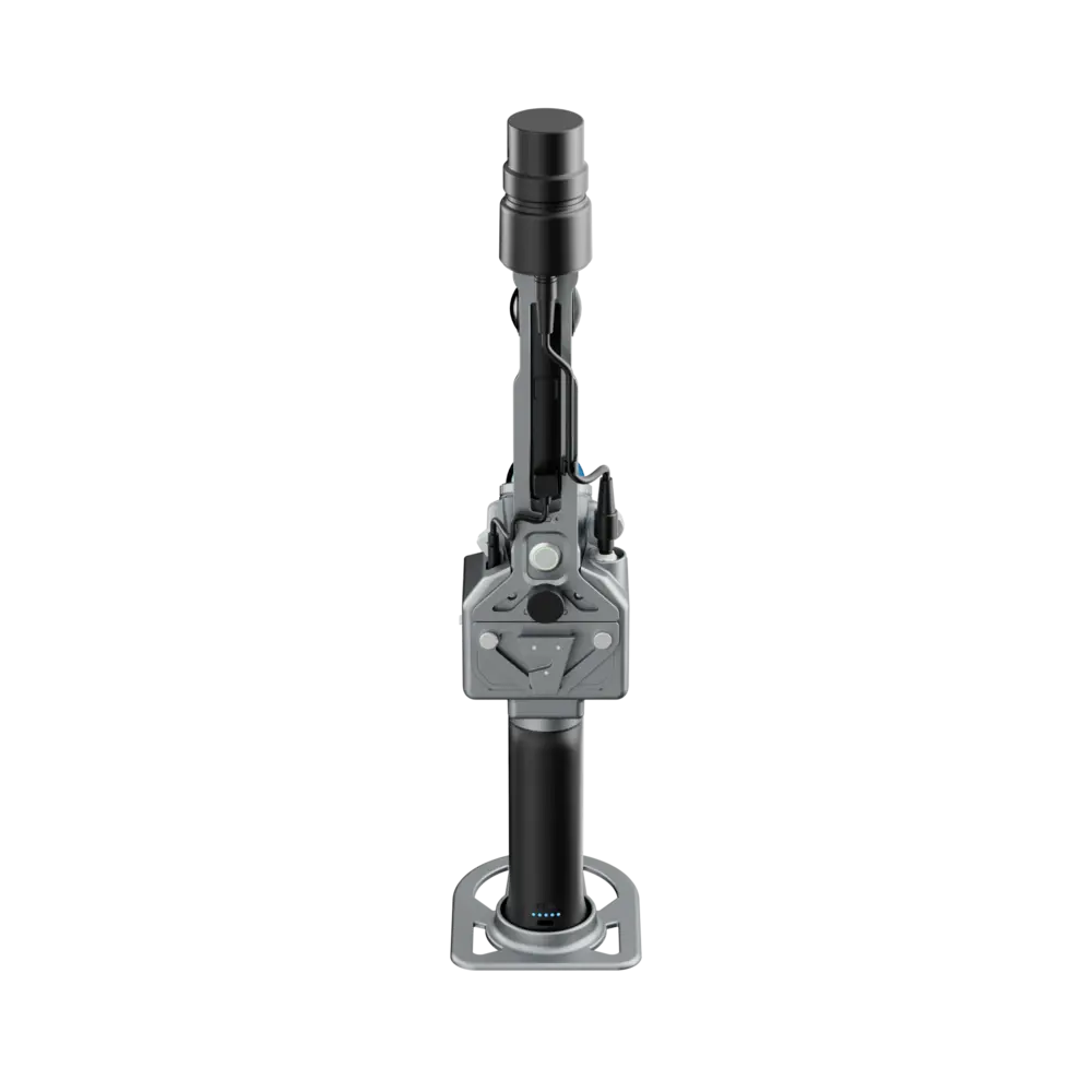
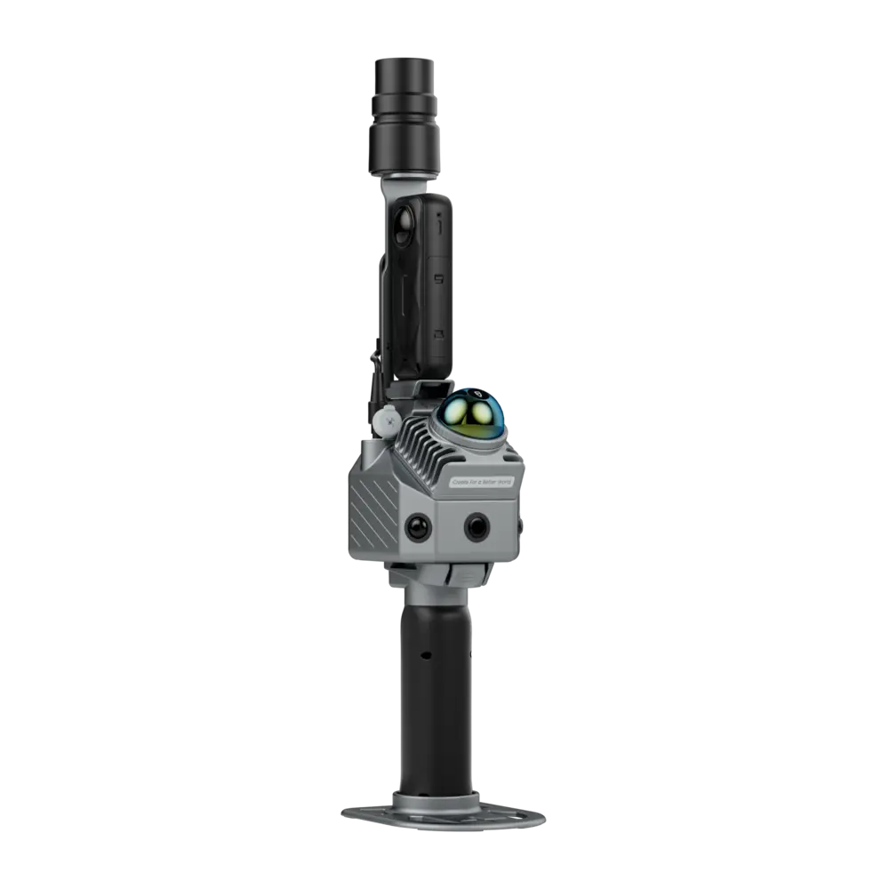
The FJD Trion P2 is a lightweight mobile SLAM LiDAR scanner for surveyors, construction teams, BIM specialists and 3D mapping professionals who need fast point-cloud capture indoors and outdoors. It combines LiDAR, visual SLAM, built-in cameras and optional RTK/PPK positioning in a compact scanner body weighing only 700 g. With a scanning range of up to 70 m, 200,000 points per second, real-time colorized point clouds and post-processed accuracy of up to 1 cm relative and 3 cm absolute, the Trion P2 is well suited to building surveys, as-built documentation, floor plans, digital twins, construction progress, facility mapping and general mobile reality capture.
FJD Trion P2 Highlights
| Scanning range | 40 m at 10% reflectivity and 70 m at 80% |
|---|---|
| Point rate | 200,000 points/sec |
| Post-processed accuracy | Relative 1 cm and absolute 3 cm |
| LiDAR field of view | 360° × 59° |
| SLAM | LiDAR and visual Multi-SLAM with RTK and PPK support |
| Cameras | 2 MP front camera and dual 48 MP side cameras |
| Scanner weight | 700 g excluding battery camera and GNSS module |
| Battery runtime | Up to 4 hours with GNSS module and no external camera |
Valued customers:










Find RTK Networks
Search NTRIP providers and connect to reliable RTK correction services.
Description
Portable SLAM LiDAR for fast professional 3D capture
The FJD Trion P2 is a compact mobile LiDAR scanner developed for surveyors, construction professionals, BIM teams, engineers, facility managers and reality-capture specialists who need to collect complete 3D information quickly. Instead of setting up a static scanner at many individual positions, the operator can walk through a site while the P2 continuously records the surrounding environment and builds a point cloud.
The scanner combines LiDAR, visual camera information and optional GNSS positioning in one connected workflow. This makes it suitable for indoor building surveys, outdoor site capture and projects that move between areas with and without reliable satellite reception.
Up to 70 metre LiDAR scanning range
The Trion P2 provides a scanning range of approximately 40 m at 10% reflectivity and up to 70 m at 80% reflectivity. This makes it practical for rooms, warehouses, industrial buildings, façades, streets, tunnels and many other environments where the important surfaces are within tens of metres of the operator.
Reflectivity matters in real fieldwork. Dark asphalt, vegetation or other low-reflectivity materials may be detected at shorter distances than brighter walls, concrete or reflective surfaces. Survey routes should therefore be planned around the actual environment rather than the maximum range alone.
200,000 points per second with full 360 degree coverage
The LiDAR records up to 200,000 points per second with a field of view of approximately 360° × 59°. As the operator moves through the project, the scanner continuously captures surrounding geometry and creates a spatial record of walls, floors, ceilings, equipment, terrain and other objects.
Point density depends on walking speed, distance to the surface and how often an area is observed. Slower movement and repeated passes can provide more coverage in locations where additional geometric detail is required.
Multi-SLAM for indoor and difficult environments
The Trion P2 uses a Multi-SLAM approach that combines LiDAR measurements with visual information and positioning constraints. This helps the system maintain its trajectory in environments where GNSS alone cannot operate, including building interiors, corridors, tunnels and other enclosed spaces.
For field crews, this means large areas can be captured by walking through them naturally instead of stopping for repeated instrument setups. It is particularly useful for jobs where speed on site matters and the project contains many rooms, floors or narrow passages.
RTK and PPK for georeferenced point clouds
With the optional GNSS module, the P2 supports RTK and PPK positioning. FJD specifies RTK performance of approximately 8 mm + 1 ppm horizontally and 15 mm + 1 ppm vertically, with a 10 Hz positioning rate.
In practical surveying workflows, RTK can connect the scan to project coordinates while collecting data, while PPK allows GNSS information to be processed after the survey. This is valuable for users who need more than a locally referenced SLAM model and want the final point cloud positioned within a real coordinate system.
Centimetre-level point-cloud accuracy
FJD specifies real-time point-cloud accuracy of approximately 2 cm relative and 5 cm absolute. After processing, the stated accuracy improves to approximately 1 cm relative and 3 cm absolute.
Relative accuracy is important for dimensions within the same scan, while absolute accuracy describes the position of the dataset within its reference system. Actual project results depend on the survey route, environment geometry, GNSS quality, control points and processing workflow, so engineering work with strict tolerances should still include suitable field checks.
Real-time colorized point clouds
A major practical feature of the Trion P2 is real-time colorized point-cloud processing. The scanner uses built-in cameras and on-device processing to add visual information to the captured geometry.
This helps the operator understand the scan while still on site. Missing rooms, occlusions or incomplete surfaces are easier to identify in a colored dataset than in a purely monochrome point cloud, reducing the risk of discovering gaps only after returning to the office.
Built-in cameras for visual SLAM and texture
The current P2 configuration uses a 2 MP front global-shutter camera together with two 48 MP side cameras. The front camera supports motion capture for visual SLAM, while the high-resolution side cameras provide image detail for colorization and visual documentation.
The P2 can also be used with supported external 360° cameras such as the Insta360 X3 and X5 where panoramic imagery is required for additional visual deliverables.
HyperDense+ for denser processed point clouds
The FJD Trion Model software includes HyperDense+, which FJD states can generate point clouds around five to seven times denser than the standard output. This is useful when the project needs smoother visual results, improved colorization or more detailed geometry for modelling and inspection.
For BIM, architecture and digital-twin work, denser processed data can make surfaces easier to interpret and provide a stronger reference for modelling. The appropriate processing level should still be selected according to the required deliverable and available computing resources.
Construction and as-built documentation
The Trion P2 is well suited to construction sites where teams need to document existing conditions, completed work or progress between project stages. A field user can walk through a floor or building and capture a complete spatial record rather than measuring only selected points.
The resulting point cloud can support as-built documentation, coordination, dimensional checks, progress records and CAD or BIM modelling. The captured dataset also allows office staff to revisit parts of the site virtually when additional dimensions are needed later.
BIM and floor plan workflows
For BIM and architectural applications, the Trion P2 can provide point clouds that serve as a reference for modelling existing structures. FJD’s software ecosystem can also support deliverables such as floor plans, meshes, panoramas and other visual outputs depending on the processing workflow.
This makes the system useful for renovation, property documentation, building conversion and projects where accurate knowledge of existing geometry is required before design work begins.
Facility management and digital twins
Facility managers can use mobile LiDAR to document rooms, corridors, installations and equipment in three dimensions. Colorized point clouds and panoramas help users understand the site remotely and provide a spatial reference for maintenance, asset documentation and future modifications.
The same captured dataset can support digital-twin workflows where geometry and visual information are used together to build a digital representation of the physical site.
Indoor tunnels and GNSS-denied spaces
The SLAM workflow makes the P2 suitable for spaces where conventional GNSS surveying is not practical. Tunnels, basements, indoor plants, parking structures and long corridors can be scanned while moving continuously through the site.
Careful survey technique still matters. Maintaining visual and geometric overlap, avoiding unnecessarily fast movement and closing loops where practical can help the SLAM system maintain a stable trajectory over larger projects.
Outdoor mapping with GNSS support
The optional GNSS module extends the P2 beyond indoor scanning. With RTK or PPK, surveyors can capture outdoor sites and connect the point cloud to project coordinates without relying only on local SLAM positioning.
This is useful for mixed indoor and outdoor projects, construction sites, infrastructure, forestry and other workflows where the operator repeatedly moves between open areas and locations with restricted satellite visibility.
Lightweight scanner for daily field use
The scanner body weighs approximately 700 g without battery, external camera and GNSS module. With the battery and GNSS module installed, the published weight is approximately 1.2 kg, or around 1.5 kg when an external camera is also fitted.
The low scanner weight is important for users who spend several hours walking through buildings or sites. It also makes the system easier to transport between jobs compared with larger static laser scanners and their supporting equipment.
Up to four hours of field operation
The P2 provides up to approximately four hours of battery operation with one set of two batteries, the GNSS module fitted and no external camera. With both GNSS and an external camera, FJD specifies around three hours.
The system supports fast charging and simultaneous dual-battery charging, helping field teams prepare batteries between survey sessions.
Large internal storage and practical data export
The P2 includes a 512 GB SSD and supports expansion up to 1 TB. Scan data can be transferred through wireless networking, USB Type-C or a USB flash drive.
Supported point-cloud formats include LAS, PLY, PTS and E57, making the output compatible with a broad range of surveying, CAD, BIM, engineering and point-cloud applications.
FJD Trion software workflow
The P2 works within the FJD Trion software ecosystem. FJD Trion Scan is used for field control and scan management, while FJD Trion Model handles processing and project outputs. Tablet versions support on-site processing and preview, while web-based tools can be used for sharing and collaboration.
This connected workflow is useful for teams that want to move from field acquisition to processed deliverables without assembling separate software from several manufacturers.
Who is the FJD Trion P2 for?
The P2 is particularly suitable for land surveyors, construction teams, BIM specialists, architects, engineers, facility managers, mining professionals and reality-capture companies that need a portable scanner for fast indoor and outdoor documentation. Its strongest combination is low weight, real-time colorized scanning, RTK/PPK support and centimetre-level processed point-cloud accuracy.
Buying the FJD Trion P2 from Global GPS Systems
The most suitable P2 configuration depends on whether the project needs GNSS positioning, panoramic imaging, indoor-only scanning or georeferenced outdoor work. Global GPS Systems can help choose the correct scanner, GNSS module, camera configuration and processing workflow for surveying, construction, BIM and professional 3D mapping projects.
Specifications
FJDynamics Trion P2 Specifications
LiDAR Scanner
| Point Rate | 200,000 points/second |
|---|---|
| Field of View | 360° × 59° |
| Scanning Range at 10% Reflectivity | 40 m |
| Scanning Range at 80% Reflectivity | 70 m |
| Laser Wavelength | 905 nm |
| Laser Safety | Class 1, eye-safe |
| Point Cloud Processing | Real-time processing |
| Real-Time Point Cloud Preview | Supported |
| Continue Scanning | Supported |
| HyperDense+ | Supported; produces approximately 5–7× denser point clouds with spacing down to approximately 1 mm depending on processing workflow |
Point Cloud Accuracy
| Processing Mode | Relative Accuracy | Absolute Accuracy |
|---|---|---|
| Real-Time Point Cloud | 2 cm | 5 cm |
| Post-Processed Point Cloud | ≤1 cm | 3 cm |
SLAM and Positioning
| SLAM Technology | Multi-SLAM fusion |
|---|---|
| LiDAR SLAM | Supported |
| Visual SLAM | Supported |
| RTK Positioning | Supported with RTK / GNSS module |
| PPK Positioning | Supported |
| RTK Horizontal Accuracy | 8 mm + 1 ppm RMS |
| RTK Vertical Accuracy | 15 mm + 1 ppm RMS |
| GNSS Positioning Rate | 10 Hz |
| GNSS-Denied Scanning | Supported through SLAM workflows |
| Georeferenced Point Clouds | Supported with RTK / PPK workflow |
GNSS Support
| BeiDou | B1I / B2I / B3I / B1C / B2a / B2b |
|---|---|
| GPS | L1 C/A / L1C / L2P(Y) / L2C / L5 |
| GLONASS | G1 / G2 / G3 |
| Galileo | E1 / E5a / E5b / E6 |
| QZSS | L1C/A / L1C / L2C / L5 |
| IRNSS | Supported through firmware upgrade |
| SBAS | Supported through firmware upgrade |
Built-In Camera System
| Camera Configuration | 1 front global-shutter camera plus 2 side RGB cameras |
|---|---|
| Front Camera Resolution | 2 MP |
| Side Camera Resolution | 2 × 48 MP |
| Front Camera Field of View | 70° |
| Side Camera Field of View | 280° × 149° |
| Visual SLAM | Supported |
| Real-Time Colorization | Supported |
| True-Color Point Clouds | Supported |
| Image Export | Supported |
| Image Format | .jpg |
External 360° Camera Support
| Camera | Video Resolution | Photo Resolution |
|---|---|---|
| Insta360 X3 | 5.7K: 5760 × 2880 at 30 / 25 / 24 fps; 4K: 3840 × 1920 at 60 / 50 / 30 / 25 / 24 fps; 3K: 3008 × 1504 at 100 fps | 72 MP (11968 × 5984) / 18 MP (5952 × 2976) |
| Insta360 X5 | 8K: 7680 × 3840 at 30 / 25 / 24 fps; 5.7K+: 5760 × 2880 at 30 / 25 / 24 fps; 5.7K: 5760 × 2880 at up to 60 fps; 4K: 3840 × 1920 at up to 120 fps | Approx. 72 MP (11904 × 5952) / approx. 18 MP (5888 × 2944) |
External Camera File Formats
| 360° Video Format | INSV |
|---|---|
| Single-Lens Video Format | MP4 |
| External Camera Colorization | Supported |
System Parameters
| Dimensions | 110 × 106 × 280 mm |
|---|---|
| Scanner Weight | 700 g, excluding battery, external camera and GNSS / RTK module |
| Weight with Battery and GNSS / RTK Module | 1200 g |
| Weight with Battery, External Camera and GNSS / RTK Module | 1500 g |
| Internal Storage | 512 GB SSD |
| Expandable Storage | Up to 1 TB |
| Operating Temperature | -20°C to +50°C |
| Storage Temperature | -40°C to +60°C |
| Ingress Protection | IP54 |
| Mounting Interface | 5/8″ standard interface for pole-mounted operation |
| Operating Modes | Handheld and pole-mounted scanning |
Power and Battery
| Power Supply | DC handheld battery |
|---|---|
| Battery Configuration | Dual-battery system |
| Battery Life with RTK Module | Up to 4 hours with one set of two batteries, excluding external camera |
| Battery Life with RTK Module and External Camera | Up to 3 hours with one set of two batteries |
| Power Consumption | 15 W excluding external camera |
| Power Consumption with External Camera | 21 W |
| Charger | 67 W fast charger |
| Simultaneous Dual-Battery Charging | Supported |
| Independent Battery Charging Time | Approximately 1.5 hours |
Connectivity and Data Export
| Wi-Fi | 2.4 GHz |
|---|---|
| Wireless Data Export | Supported |
| USB Interface | USB Type-C |
| USB Flash Drive Export | Supported |
| Point Cloud Format | .las / .ply / .pts / .e57 |
Scanning and Processing Features
| Real-Time Point Cloud Generation | Supported |
|---|---|
| Real-Time True-Color Point Cloud | Supported |
| On-Device Processing | Supported |
| Scan Continuation | Supported |
| Point Cloud Colorization | Supported with built-in or compatible external cameras |
| HyperDense+ | Supported |
| RTK Registration | Supported |
| PPK Processing | Supported |
| Indoor Scanning | Supported |
| Outdoor Scanning | Supported |
| Tunnel and Corridor Mapping | Supported |
| Feature-Poor Environment Mapping | Multi-SLAM fusion designed to improve performance in environments such as tunnels, open areas and parks |
Supported Deliverables
| 3D Point Clouds | Supported |
|---|---|
| Colorized Point Clouds | Supported |
| 2D Floor Plans | Supported through FJD Trion processing workflows |
| 3D Mesh Models | Supported through FJD Trion processing workflows |
| 3D Gaussian Splatting | Supported through compatible FJD Trion processing workflows |
| Georeferenced Panoramas | Supported with compatible camera and GNSS workflow |
| CAD / BIM Data Workflows | Supported |
Software Ecosystem
| FJD Trion Scan | App-based scanner control, real-time monitoring and scan file management |
|---|---|
| FJD Trion Model | Desktop point cloud processing, mapping, colorization, analysis and deliverable generation |
| FJD Trion Model for Tablets | On-site processing and preview with supported iPad and Android devices |
| FJD Trion Model Web | Online data sharing and collaborative project workflows |
| E57 Workflow | Supported |
| Point Cloud Classification | Supported in compatible FJD Trion Model workflows |
| Point Cloud Registration | Supported |
| Point Cloud Merging | Supported |
| Mesh Generation | Supported |
| Volume Calculation | Supported in compatible processing workflows |
| Profile Analysis | Supported |
Typical Applications
| Land Surveying | Supported |
|---|---|
| Construction Documentation | Supported |
| Construction Progress Capture | Supported |
| As-Built Surveying | Supported |
| BIM Workflows | Supported |
| CAD Workflows | Supported |
| Digital Twins | Supported |
| Facility Mapping | Supported |
| Indoor Mapping | Supported |
| Tunnel Mapping | Supported |
| Forestry | Supported |
| Mining and Quarrying | Supported |
| Infrastructure Inspection | Supported |
| Forensic and Incident Documentation | Supported |
| Architecture and Heritage Documentation | Supported |
| Mobile 3D Reality Capture | Supported |
Configuration Options
| Configuration | Main Components | Typical Function |
|---|---|---|
| RTK Module Configuration | Trion P2 with GNSS / RTK module | Georeferenced RTK / PPK scanning |
| Panoramic Camera + RTK Configuration | Trion P2, compatible panoramic external camera and GNSS / RTK module | Georeferenced scanning with panoramic image capture and enhanced colorization |
Specifications and package contents may vary by configuration, region or manufacturer update. Always check the current configuration before ordering.
Reviews (1)
1 review for FJ Dynamics Trion P2
Only logged in customers who have purchased this product may leave a review.
FAQ
FJ Dynamics Trion P2 FAQ
Scanning Performance & Accuracy
What is the FJ Dynamics Trion P2?
The FJ Dynamics Trion P2 is a portable professional LiDAR scanner for mobile 3D mapping and reality capture. It combines LiDAR, built-in cameras, Visual SLAM and optional RTK/PPK positioning for surveying, construction documentation, BIM, digital twins, facility mapping and other indoor and outdoor scanning applications.
What accuracy can the FJD Trion P2 achieve?
The Trion P2 is specified with post-processed relative point cloud accuracy of ≤1 cm and absolute accuracy of 3 cm under suitable conditions. FJDynamics notes that these are laboratory-tested values, so actual project accuracy can vary depending on the environment, scanning method, control, positioning and processing workflow.
What is the scanning range of the FJD Trion P2?
The Trion P2 has a specified range of 40 metres on targets with 10% reflectivity and up to 70 metres on targets with 80% reflectivity. Actual range varies with surface reflectivity, incidence angle and environmental conditions.
How many points per second does the Trion P2 capture?
The Trion P2 captures up to 200,000 LiDAR points per second. Combined with its 360° × 59° LiDAR field of view, this allows the operator to rapidly collect dense three-dimensional information while walking through a site.
What is HyperDense+ on the FJD Trion P2?
HyperDense+ is a processing feature available in the FJD Trion workflow that can create significantly denser point cloud output. FJDynamics specifies point clouds up to 5–7 times denser with spacing down to approximately 1 mm, making it useful for detailed modelling, visualisation and documentation.
Is the Trion P2 LiDAR eye-safe?
Yes. The Trion P2 uses a 905 nm Class 1 laser, which is classified as eye-safe under normal operating conditions. Users should still operate the scanner according to the manufacturer's safety instructions.
SLAM, RTK & Field Operation
Can the FJD Trion P2 scan indoors without GNSS?
Yes. The Trion P2 uses LiDAR and Visual SLAM to determine its movement through the environment, allowing it to scan inside buildings and other areas where GNSS satellite signals are unavailable. This makes it suitable for rooms, corridors, staircases, tunnels and other indoor environments.
Does the FJD Trion P2 support RTK?
Yes. The Trion P2 supports an RTK module for projects that require georeferenced point clouds. The specified RTK accuracy is 8 mm + 1 ppm RMS horizontally and 15 mm + 1 ppm RMS vertically under suitable GNSS correction conditions.
Does the Trion P2 support PPK processing?
Yes. PPK is supported. This allows GNSS observations to be processed after data collection, providing an alternative to receiving real-time RTK corrections during the scan and supporting georeferenced surveying workflows.
What is Multi-SLAM on the FJD Trion P2?
The Trion P2 uses multiple sources of positioning information, including LiDAR SLAM, visual camera information and, when configured, RTK or PPK positioning. Combining these technologies helps maintain a stable trajectory across different scanning environments and supports transitions between indoor, outdoor and GNSS-challenging areas.
Can the Trion P2 continue scanning between different areas?
Yes. The Trion P2 supports continued scanning, allowing operators to capture larger or more complex environments as part of a practical mobile scanning workflow. Good scanning practice, sufficient overlap and appropriate loop closures remain important for maintaining point cloud quality.
Can the FJD Trion P2 be mounted on a survey pole?
Yes. In addition to handheld scanning, the Trion P2 has a standard 5/8-inch interface for pole mounting. Pole mounting can be useful when a different scanning height is required or when integrating the scanner into a surveying workflow.
Applications, Cameras & Deliverables
What is the FJD Trion P2 used for?
The Trion P2 is designed for applications including land surveying, construction progress documentation, as-built surveys, BIM and CAD workflows, floor plan creation, facility management, digital twins, indoor mapping, forestry, mining, infrastructure documentation, tunnels and general 3D reality capture.
Is the FJD Trion P2 suitable for BIM and as-built surveys?
Yes. The Trion P2 can rapidly capture buildings and construction sites as dense 3D point clouds. These datasets can be used as references for BIM modelling, CAD drawings, as-built documentation, design verification, renovation projects and construction progress monitoring.
Can the Trion P2 generate colorized point clouds?
Yes. The Trion P2 has built-in cameras and supports real-time true-color point cloud visualisation. Color information makes scanned environments easier to interpret and can help operators identify missing areas or occlusions before leaving the site.
What cameras are built into the FJD Trion P2?
The Trion P2 includes a 2 MP front camera with a 70° field of view and two 12 MP side cameras covering approximately 280° × 149°. The camera system supports Visual SLAM, point cloud colorization and JPG image export.
Can an external 360° camera be used with the Trion P2?
Yes. The Trion P2 supports compatible Insta360 external cameras, including the Insta360 X3 and Insta360 X5. An external panoramic camera can add high-resolution 360° visual documentation to LiDAR projects, including workflows involving georeferenced panoramas and immersive site visualisation.
Can the Trion P2 create floor plans and 3D models?
Yes. Depending on the FJD Trion software workflow, data captured with the Trion P2 can be used to generate deliverables such as 2D floor plans, point clouds, 3D mesh models, georeferenced panoramas and 3D visualisation outputs. This allows one scanning session to support multiple surveying, construction and digital twin deliverables.
Hardware, Battery & Software
How much does the FJD Trion P2 weigh?
The Trion P2 scanner body weighs approximately 700 g excluding the battery, external camera and RTK module. The system weighs approximately 1.2 kg with the battery and RTK module, or approximately 1.5 kg when configured with the battery, RTK module and external camera.
How long does the FJD Trion P2 battery last?
The specified battery life is up to approximately 4 hours using one set of two batteries with the RTK module and without an external camera. With the RTK module and external camera in use, the specified operating time is approximately 3 hours. Actual runtime can vary with operating conditions and configuration.
How much storage does the Trion P2 have?
The FJD Trion P2 has 512 GB of storage and supports expansion up to 1 TB. Data can be transferred using a wireless network, USB Type-C connection or USB flash drive.
Which point cloud formats can the Trion P2 export?
The Trion P2 workflow supports commonly used point cloud formats including LAS, PLY, PTS and E57. These formats allow processed data to be transferred into compatible CAD, BIM, GIS, surveying, modelling and third-party point cloud software.
What software is used with the FJD Trion P2?
The Trion P2 works with the FJD Trion software ecosystem. FJD Trion Scan is used for scanner control and data collection, FJD Trion Model provides point cloud processing and deliverable generation, FJD Trion Model for Tablets supports on-site processing and preview on compatible tablets, and FJD Trion Explorer supports online sharing and collaboration.
Is the FJD Trion P2 weather resistant?
The Trion P2 has an IP54 ingress protection rating, providing protection against limited dust ingress and water splashes. It is not designed for immersion or unrestricted exposure to severe weather. The specified operating temperature range is -20°C to 50°C.
Can Trion P2 data be used in third-party CAD, BIM and point cloud software?
Yes. The ability to export standard point cloud formats such as LAS, E57, PLY and PTS makes Trion P2 data suitable for use with compatible third-party CAD, BIM, GIS and point cloud applications. The exact workflow depends on the file formats and point cloud functions supported by the target software.
 GPS & GNSS
 Total Stations
 Data collectors
 Software
 Correction services
 Machine control
 External radio
 Marine
 Accessories
Dario Petrescu (verified owner) –
Very good lidar, nice and light