

 GPS & GNSS
 Lidar scanning
 Total Station
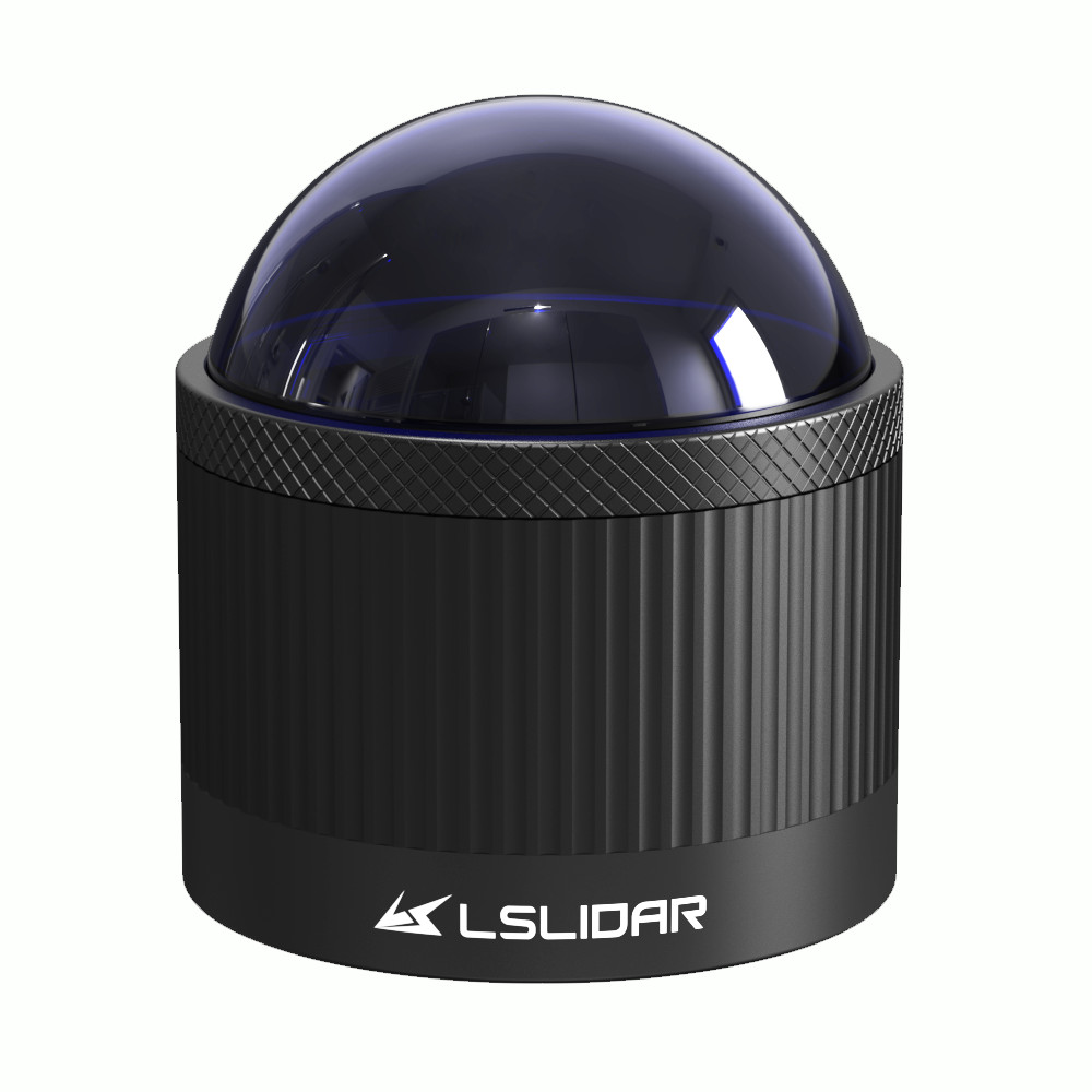
LS Lidar CHR Series 360 Degree Ultra Wide 3D LiDAR
Get the best price for your setup
Contact our experts for the best possible price and configuration.
- Fast response
- Expert configuration advice
- No overpaying for features you do not need
The LS Lidar CHR Series is an ultra-wide-angle 3D LiDAR range designed for autonomous machines, robotics, mobile mapping, industrial vehicles and blind-spot detection. Available as the 16-channel CH16R and 32-channel CH32R, the series combines full 360° horizontal scanning with vertical coverage of up to approximately 90°. Both models provide up to 120 m detection at 70% reflectivity, 30 m at 10% reflectivity and ±3 cm range accuracy. The CH32R generates up to 1.28 million points per second in dual-echo mode, providing dense close-range 3D coverage around vehicles, robots and machinery.
LS Lidar CHR Series Highlights
| LiDAR type | 16 or 32-channel mechanical 3D LiDAR |
|---|---|
| Models | CH16R and CH32R |
| Detection range | 120 m at 70% reflectivity, 30 m at 10% |
| Range accuracy | ±3 cm, ±1 cm precision (1σ) |
| Field of view | 360° horizontal, up to approx. 90° vertical |
| Maximum point rate | Up to 1,280,000 pts/s with CH32R dual echo |
| Protection | IP67 |
Valued customers:










Find RTK Networks
Search NTRIP providers and connect to reliable RTK correction services.
Description
Ultra Wide Angle 3D LiDAR for Blind Spot Detection and Mapping
The LS Lidar CHR Series is a range of multi-channel mechanical 3D LiDAR sensors developed for applications that need broad coverage around a vehicle, robot or machine. Available as the CH16R and CH32R, the series combines complete 360° horizontal scanning with an unusually large vertical field of view. This makes it particularly useful for detecting nearby objects, reducing blind areas and capturing detailed 3D information around the sensor.
The CHR Series is suitable for autonomous vehicles, unmanned forklifts, service robots, logistics equipment, industrial machinery, mobile mapping, surveying, security and port applications. Rather than concentrating primarily on long-distance forward detection, its design places strong emphasis on wide-area coverage around the platform.
CH16R and CH32R Models
The series is available with either 16 or 32 scanning channels. The CH16R uses 16 laser beams and provides a vertical field of view from approximately 2.5° to 52.8°. The CH32R doubles the number of channels and extends vertical coverage to approximately 89.1°, creating almost hemispherical coverage around the sensor.
Both models use the same 905 nm Time of Flight measurement principle and provide full 360° horizontal scanning. The choice between them mainly depends on the required vertical coverage and point density. Applications requiring detailed 3D information close to the machine will generally benefit most from the 32-channel CH32R.
Nearly 360 by 90 Degree Coverage
The CH32R provides a 360° horizontal field of view and almost 90° vertical field of view. This is one of the strongest features of the CHR Series because it allows the LiDAR to measure a large area around and below its mounting position.
For an unmanned forklift, mobile robot or construction machine, this can help detect nearby obstacles that may fall outside the viewing area of a conventional forward-facing LiDAR. The large vertical angle is also useful when the sensor is installed above ground level and needs to observe objects close to the vehicle.
Up to 120 Metres Detection Range
Both the CH16R and CH32R are specified for a detection range of up to 120 metres at 70% target reflectivity and approximately 30 metres at 10% reflectivity. The 10% figure provides an important reference for darker objects such as tyres, dark vehicles, road surfaces and industrial materials.
Actual working range depends on target reflectivity, weather, installation and environmental conditions. For the main blind-spot and robotics applications of the CHR Series, its combination of close-range coverage and wide field of view is generally more important than maximum long-range performance.
Dense Point Clouds with Dual Echo
The CH32R produces up to approximately 640,000 points per second in single-echo mode and 1,280,000 points per second in dual-echo mode. The CH16R generates approximately 320,000 points per second with a single echo and up to 640,000 points per second with dual echo.
Dual-echo measurement allows the LiDAR to record more than one return from a laser pulse in suitable conditions. This can provide additional information when the beam interacts with partially transparent, irregular or complex surfaces and also doubles the maximum output point rate.
±3 cm Range Accuracy and ±1 cm Precision
The CHR Series has a specified range accuracy of ±3 cm and range precision of ±1 cm at 1σ. These specifications describe different characteristics. Accuracy indicates how closely a measured distance corresponds to the actual distance, while precision describes the repeatability of successive measurements.
For robotics, obstacle detection and industrial perception, repeatable measurements help software maintain stable object positions as the sensor scans continuously. For mapping applications, overall point-cloud accuracy will also depend on calibration, mounting and the GNSS or IMU system used to position the LiDAR.
Adjustable 5 10 and 20 Hz Scanning
The CH16R and CH32R support scan frequencies of 5, 10 and 20 Hz. This gives integrators a choice between higher measurement density per rotation and faster environmental updates.
A 20 Hz configuration provides frequent updates for moving robots, vehicles and machines, while slower settings can provide greater horizontal point density where rapid updates are less important. Horizontal angular resolution can accordingly be configured at approximately 0.09°, 0.18° or 0.36°.
Designed for Close Range Blind Spot Coverage
The CHR Series is particularly well suited to applications where conventional LiDAR sensors leave significant blind areas near the platform. Its large vertical field of view allows measurements to extend substantially downward from the sensor, helping perception software observe the ground and nearby objects.
This is valuable on forklifts, autonomous industrial vehicles, port equipment and other machines where people, pallets, barriers or objects may be located very close to the vehicle. The LiDAR provides measurement data that can be used by the vehicle’s perception or control software for obstacle awareness and navigation.
Useful for Mobile Mapping and SLAM
The 360° horizontal coverage also makes the CHR Series suitable for SLAM and mobile mapping. As a platform moves through an environment, surrounding walls, structures, equipment and terrain are repeatedly captured from different positions.
When combined with suitable SLAM software, GNSS or an IMU, these measurements can be used for localisation and 3D mapping. Surveyors and mapping professionals should consider the complete system accuracy, because the LiDAR’s ranging specification is only one component of a georeferenced point-cloud workflow.
905 nm Time of Flight LiDAR
The CHR Series uses a 905 nm Class 1 laser and Time of Flight measurement technology. Each laser pulse travels toward a surrounding surface and the sensor determines distance from the time required for the reflected signal to return.
Because LiDAR actively generates its own measurement signal, it can operate independently of normal visible lighting conditions. Environmental effects such as heavy rain, fog, dust and contamination on the sensor window can still influence optical measurement performance.
Ethernet Integration and Synchronisation
The standard sensors use 100BASE-TX Ethernet for point-cloud communication and support PPS timing for synchronization with other equipment. This allows the LiDAR to be connected to an industrial computer, robot controller or mobile mapping system.
Synchronization is especially useful when LiDAR measurements need to be combined with GNSS, an IMU or cameras. Correct timing helps ensure that measurements from different sensors refer to the same moment while the platform is moving.
CH32R PoE Option
A CH32R PoE version is also available for applications where simplified installation is useful. Power over Ethernet allows power and data to use the same Ethernet connection, reducing the amount of separate cabling required.
This can simplify installations on robots, vehicles and industrial machinery, particularly where cable routing is difficult. The exact power and interface requirements should be checked for the chosen standard or PoE version before integration.
Industrial Environmental Protection
The CH16R and CH32R carry an IP67 protection rating and are specified for operation from approximately -20°C to +60°C. The sensors are also tested for vibration and mechanical shock, supporting installation on moving vehicles, robots and industrial machines.
The standard units measure approximately 100 mm in diameter and 110 mm high and weigh around 1 kg. The CH16R typically consumes around 10 W at 10 Hz, while the CH32R uses approximately 12 W.
Typical CHR Series Applications
- Autonomous vehicles and ADAS development
- Unmanned forklifts and warehouse vehicles
- Service robots and autonomous mobile robots
- Construction and industrial machine blind-spot detection
- Mobile mapping and 3D SLAM
- Logistics and port automation
- Security and environmental monitoring
Choosing Between CH16R and CH32R
The CH16R is suitable when 16 measurement layers and approximately 50° of vertical coverage provide enough information for the application. Its lower point rate and slightly lower power consumption can make it an efficient option for less demanding perception systems.
The CH32R is better suited to applications that need maximum surrounding coverage. Its 32 channels, almost 90° vertical field of view and up to 1.28 million points per second provide a much denser 3D view around the sensor, making it particularly attractive for blind-spot detection, robotics and detailed mobile mapping.
Buying the LS Lidar CHR Series from Global GPS Systems
Global GPS Systems supplies LiDAR, GNSS and professional positioning equipment for surveying, mapping, robotics, construction and autonomous-machine applications. Our team can help determine whether the CH16R or CH32R provides the right vertical coverage, point density and interface for your project.
For mobile mapping and autonomous applications, the LiDAR can also be combined with GNSS, IMU, cameras and suitable processing software. Global GPS Systems can help evaluate the complete sensor setup so the hardware matches the required field workflow and integration environment.
Datasheets & Manuals
Specifications
LSLiDAR CHR Series CH16R / CH32R Ultra-Wide Angle LiDAR Specifications
Product Overview
| Product family | LSLiDAR CHR Series |
|---|---|
| Manufacturer model family | CH16R / CH32R Ultra-Wide Angle Blind Spot LiDAR |
| Models listed by Global GPS Systems | CH16R and CH32R |
| Additional manufacturer variant | CH32R PoE |
| Product type | Multi-line mechanical 3D LiDAR |
| Measurement principle | Time of Flight (ToF) |
| CH16R channels | 16 |
| CH32R channels | 32 |
| Horizontal scanning coverage | 360° |
| Maximum vertical coverage | Approximately 90° on CH32R |
| Maximum detection range | 120 m at 70% target reflectivity |
| Low-reflectivity detection range | 30 m at 10% target reflectivity |
| Maximum point generation rate | 1,280,000 points/second on CH32R in dual-echo mode |
| Primary applications | Blind-spot detection, autonomous systems, ADAS, intelligent transportation, robotics, unmanned forklifts, logistics, SLAM, surveying and mapping, security, ports and industrial automation |
Model Comparison
| Specification | CH16R | CH32R | CH32R PoE |
|---|---|---|---|
| Channels | 16 | 32 | 32 |
| Measurement method | ToF | ToF | ToF |
| Wavelength | 905 nm | 905 nm | 905 nm |
| Laser class | Class 1 | Class 1 | Class 1 |
| Detection range at 10% reflectivity | 30 m | 30 m | 30 m |
| Detection range at 70% reflectivity | 120 m | 120 m | 120 m |
| Range accuracy | ±3 cm | ±3 cm | ±3 cm |
| Range precision | ±1 cm | ±1 cm | ±1 cm |
| Horizontal FOV | 360° | 360° | 360° |
| Vertical FOV | 2.487° to 52.798° | 2.487° to 89.105° | 2.487° to 89.105° |
| Minimum vertical resolution | 2.618° | 2.61° | 2.61° |
| Frame / scan rates | 5 / 10 / 20 Hz | 5 / 10 / 20 Hz | 5 / 10 / 20 Hz |
| Single-echo point rate | 320,000 pts/s | 640,000 pts/s | 640,000 pts/s |
| Dual-echo point rate | 640,000 pts/s | 1,280,000 pts/s | 1,280,000 pts/s |
| Typical operating power | 10 W at typical operating conditions | 12 W at typical operating conditions | 12 W |
| Standard input | 12–32 VDC | 12–32 VDC | 36–57 VDC PoE |
| Ingress protection | IP67 | IP67 | IP67 |
| Weight | 1000 g | 1000 g | Approximately 1050 g |
| Dimensions | Ø100 × 110 mm | Ø100 × 110 mm | Ø100 × 124 mm |
Laser and Ranging Specifications
| Laser wavelength | 905 nm |
|---|---|
| Laser safety class | Class 1, eye-safe under specified operating conditions |
| Ranging method | Direct Time of Flight |
| Maximum range | 120 m at 70% reflectivity |
| Range at 10% reflectivity | 30 m |
| Range accuracy | ±3 cm |
| Range precision | ±1 cm |
| CH32R beam divergence – fast axis | 5.7 mrad |
| CH32R beam divergence – slow axis | 8.7 mrad |
| CH16R beam divergence – fast axis | 5.7 mrad |
| CH16R beam divergence – slow axis | 8.7 mrad |
Scanning Geometry
| Specification | CH16R | CH32R |
|---|---|---|
| Horizontal field of view | 360° | 360° |
| Vertical beam coverage | 2.487° to 52.798° | 2.487° to 89.105° |
| Approximate vertical coverage span | 50.311° | 86.618° |
| Minimum vertical angular resolution | 2.618° | 2.61° |
| Laser transmitter / receiver pairs | 16 | 32 |
| Scanning mechanism | Rotating mechanical scanning system | Rotating mechanical scanning system |
Horizontal Resolution and Scan Rate
| Scan Rate | Motor Speed | Horizontal Resolution |
|---|---|---|
| 5 Hz | 300 rpm | 0.09° |
| 10 Hz | 600 rpm | 0.18° |
| 20 Hz | 1200 rpm | 0.36° |
Point Cloud Performance
| Output Mode | CH16R | CH32R |
|---|---|---|
| Single echo | 320,000 points/second | 640,000 points/second |
| Dual echo | 640,000 points/second | 1,280,000 points/second |
Echo and Point Data
| Single-echo mode | Supported |
|---|---|
| Dual-echo mode | Supported |
| Measured distance | Included in point-cloud output |
| Horizontal angle | Included |
| Vertical channel angle | Determined using the individual channel calibration data |
| Intensity | Included |
| Timestamp | Included |
| Cartesian coordinates | X, Y and Z coordinates can be calculated from calibrated range and angular data |
| Channel calibration | Individual vertical-angle calibration data is provided for accurate point-cloud calculation |
Communication Interfaces
| Interface | CH16R | CH32R | CH32R PoE |
|---|---|---|---|
| Ethernet | Supported | Supported | Supported |
| 100BASE-TX | Supported | Supported | Supported through applicable PoE Ethernet interface |
| 100BASE-T1 | Configuration-dependent | Supported in current CH32R documentation | Configuration-dependent |
| PPS | Supported | Supported | Supported according to interface configuration |
| Power over Ethernet | No | No | Yes |
| Industrial Ethernet | Standard Ethernet / PPS | Standard Ethernet / PPS with available interface variants | 100M Industrial Ethernet |
CH32R 100BASE-TX / 100BASE-T1 Interface
| Standard Ethernet option | 100BASE-TX |
|---|---|
| Automotive Ethernet option | 100BASE-T1 |
| 100BASE-TX data signals | TD+, TD−, RD+ and RD− |
| 100BASE-T1 data signals | 100BASE-T1-P and 100BASE-T1-N |
| GPS synchronization input | GPS_PPS and GPS_REC |
| 100BASE-T1 documented maximum transmission distance | Up to 25 m according to the current CH32R manual |
| Default connection accessory | Adapter cable documented by the manufacturer |
Network Configuration
| Default LiDAR IP address | 192.168.1.200 |
|---|---|
| Default host / destination IP address | 192.168.1.102 |
| LiDAR UDP device packet port | 2368 |
| LiDAR UDP data packet port | 2369 |
| Host device packet port | 2369 |
| Host data packet port | 2368 |
| Typical subnet mask | 255.255.255.0 |
| Source IP configuration | Configurable |
| Destination IP configuration | Configurable |
| Gateway configuration | Supported |
| Multicast operation | Supported subject to documented IP and port restrictions |
| MAC address | Factory assigned and read-only |
UDP Communication Protocols
| Protocol | Function | Documented Packet Length |
|---|---|---|
| MSOP | Main data stream containing measured point-cloud data and timestamps | 1254 bytes |
| DIFOP | Device information, configuration and operating-status output | 1248 bytes |
| UCWP | User configuration write protocol | 1248 bytes |
Protocol and Configuration Functions
| Point-data byte order | Little-endian in the current CH32R MSOP protocol |
|---|---|
| Motor speed configuration | 5 Hz, 10 Hz or 20 Hz |
| Rotation / stationary control | Supported |
| IP address configuration | Supported |
| UDP port configuration | Supported |
| Clock source selection | GPS or PTP |
| PPS horizontal-angle alignment | Configurable with 0.01° units |
| PPS alignment error monitoring | Supported |
| Internal temperature monitoring | Multiple internal temperature values are available through device information data |
| Internal humidity monitoring | Available in applicable device-status data |
| GPS status monitoring | Supported |
| PPS status monitoring | Supported |
Time Synchronization
| GPS synchronization | Supported |
|---|---|
| External PPS synchronization | Supported |
| gPTP synchronization | Supported |
| Internal timing | Used when no external synchronization source is present |
| Point-cloud timestamp resolution | Nanosecond timing is used by the documented synchronized timestamp system |
| GPS UTC message | $GPRMC |
| GPS serial baud rate | 9600 baud |
| GPS serial format | 8 data bits, no parity, 1 stop bit |
| GPS interface levels | TTL and RS-232 variants documented for CH32R |
| External PPS input level | 3.3–5 V |
| External PPS trigger | Rising edge |
| Minimum PPS high pulse width | Greater than 1 ms |
| GNSS / INS data association | LiDAR timestamps can be matched with external pitch, roll, yaw, latitude, longitude and height information |
Electrical Specifications
| Specification | CH16R | CH32R |
|---|---|---|
| Nominal documented operating range | 12–32 VDC | 12–32 VDC |
| Broader CH32R power-input range documented in power appendix | Refer to exact hardware revision | 9–36 VDC |
| Typical operating power | 10 W | 12 W |
| Maximum operating power | 20 W | 25 W |
| Higher startup demand at low temperature | Yes | Yes |
CH32R Power Supply Requirements
| Documented allowable power-input range | 9–36 VDC in the latest CH32R power-supply appendix |
|---|---|
| Manufacturer recommended supply voltages | 12 V, 19 V, 24 V or 32 VDC depending on installation and cable length |
| Recommended source power capability | At least 30 W |
| Maximum recommended ripple noise | <100 mV peak-to-peak |
| Recommended voltage accuracy | <5% |
| Recommended DC wire size | 18–26 AWG |
| Long cable consideration | Supply voltage should account for cable voltage drop and increased startup power demand |
CH32R PoE Variant
| Model | CH32R PoE |
|---|---|
| Power and data connection | Single Ethernet cable |
| PoE input voltage | 36–57 VDC |
| Maximum manufacturer-described power delivery distance | Up to 100 m |
| Data interface | 100M Industrial Ethernet |
| Overload protection | Supported |
| Short-circuit protection | Supported |
| Overvoltage protection | Supported |
| Over-temperature shutdown protection | Supported |
| Power protection method | Hiccup-mode protection documented by LSLiDAR |
| Weight | Approximately 1050 g |
| Dimensions | Ø100 × 124 mm |
Environmental Specifications
| Ingress protection | IP67 |
|---|---|
| Operating temperature | -20°C to +60°C |
| Storage temperature | -40°C to +85°C |
| Vibration test | 5–2000 Hz, 3 g RMS |
| Shock test | 500 m/s² for 11 ms |
| Approximate shock acceleration | Approximately 51 g |
| Outdoor operation | Suitable for outdoor applications within the stated environmental and IP limits |
| High-temperature installation consideration | Manufacturer recommends adequate heat dissipation, particularly in high ambient temperatures or prolonged direct sunlight |
Mechanical Specifications
| Specification | CH16R | CH32R | CH32R PoE |
|---|---|---|---|
| Diameter | 100 mm | 100 mm | 100 mm |
| Height | 110 mm | 110 mm | 124 mm |
| Weight | 1000 g | 1000 g | Approximately 1050 g |
| Optical center location | Documented relative to the sensor central axis for integration | Documented relative to the sensor central axis for integration | Variant-specific |
| Zero-angle reference | Cable-connector direction by default; configurable to the opposite direction in software | Cable-connector direction by default; configurable to the opposite direction in software | Configuration-dependent |
Windows Software
| Manufacturer application | LSLiDAR Upper Computer Platform / Windows point-cloud display software |
|---|---|
| Live point-cloud display | Supported |
| LiDAR parameter configuration | Supported |
| LiDAR testing | Supported |
| Fault detection | Supported |
| Network configuration | Supported |
| Motor-speed configuration | Supported |
| Clock-source configuration | Supported |
| Wireshark use | Documented for Ethernet / ARP discovery and network diagnostics |
Linux and ROS Support
| Linux operation | Supported through LSLiDAR ROS drivers |
|---|---|
| ROS point-cloud driver | Available through the LSLiDAR service package |
| CH32R documented decoder package | lslidar_c32_decoder |
| RViz visualization | Supported |
| Linux network diagnostics | ping, ifconfig and tcpdump workflows documented |
| Driver configuration | Destination ports, motor speed and other applicable parameters can be matched to the LiDAR configuration |
Installation and Maintenance
| Mounting requirement | Secure the LiDAR base with correctly specified fasteners |
|---|---|
| Heat dissipation | Mounting base should provide adequate thermal dissipation |
| Optical surface handling | Manufacturer recommends powder-free clean gloves during installation |
| Recommended storage environment | Ventilated and dry |
| Recommended storage temperature when possible | 23 ±5°C |
| Recommended storage humidity | 30%–70% RH |
| User disassembly | Not recommended; unauthorized disassembly can compromise waterproofing and safety |
| Optical window contamination | Fingerprints, mud, leaves, insects and other contamination can reduce ranging performance |
| Optical cleaning | Use a clean dust-free cloth or dry air for light contamination |
| Stubborn contamination | Manufacturer documentation permits careful cleaning with a dust-free cloth and 99% absolute ethanol |
Blind-Spot and Close-Range Perception
| Ultra-wide vertical coverage | CH32R provides nearly 90° vertical coverage for close-range and blind-spot sensing |
|---|---|
| Full horizontal coverage | 360° |
| Low blind-zone application | Designed for close-range perception around robots, vehicles and industrial equipment |
| 3D obstacle detection | Supported application |
| Near-field environment mapping | Supported application |
| Multi-echo operation | Dual-echo capability provides additional returned-point information in complex scenes |
Typical Applications
| Application | Typical CHR Series Function |
|---|---|
| Autonomous vehicles | 360° environmental perception and near-field obstacle detection |
| ADAS development | 3D object and blind-spot sensing |
| Unmanned forklifts | Obstacle detection, navigation and surrounding-environment perception |
| Service robots | 3D navigation, SLAM and obstacle avoidance |
| Delivery robots | Near-field perception and navigation |
| Robo-trucks / robotaxis | 360° perception as part of a multi-sensor autonomous-driving system |
| Intelligent transportation | Road-user and environment detection |
| Surveying and mapping | Dense 3D point-cloud acquisition |
| Industrial automation | Environment monitoring, collision avoidance and machine perception |
| Ports and logistics | Equipment perception, navigation and obstacle detection |
| Security | 3D environmental monitoring and object detection |
| 3D SLAM | Dense 360° point-cloud input for compatible SLAM software |
Documentation and Specification Notes
| Global GPS Systems product designation | LS LiDAR CHR Series |
|---|---|
| Manufacturer designation | CH16R / CH32R Ultra-Wide Angle Blind Spot LiDAR |
| CH32R manual researched | CH32R User Manual V4.0.9, January 2025 |
| CH16R manual researched | CH16R User Manual V4.0.0, November 2023 |
| Manufacturer brochure researched | LSLiDAR English Product Brochure EN-V2.2-24.10.23 |
| Accuracy terminology note | The detailed manufacturer manuals distinguish range accuracy of ±3 cm from range precision of ±1 cm. Some manufacturer and seller summary material describes the product more generally as having ±1 cm accuracy. |
| 360° × 90° specification note | The approximately 360° × 90° maximum field of view and 1.28 million points/second output refer specifically to the 32-channel CH32R in dual-echo operation; the CH16R has a smaller vertical field of view and lower point rate. |
| Power specification note | The detailed CH32R manual specifies 12–32 VDC in its principal specification table and 9–36 VDC in the power-supply appendix. System designers should use the electrical specification supplied with the exact production revision. |
| Interface specification note | Communication options vary by model and production configuration, including 100BASE-TX, 100BASE-T1, PPS and the CH32R PoE industrial-Ethernet version. |
Specifications and package contents may vary by configuration, region or manufacturer update. Always check the current configuration before ordering.
Additional information
| Model | CH16R, CH32R |
|---|
Reviews (0)
Only logged in customers who have purchased this product may leave a review.
FAQ
LS LiDAR CHR Series FAQ
CHR Series Models & Applications
What is the LS LiDAR CHR Series?
The LS LiDAR CHR Series is a range of mechanical multi-channel 3D LiDAR sensors designed for high-speed environmental scanning, obstacle detection, mapping and autonomous navigation. The series combines 360° horizontal scanning with a very wide vertical field of view, making it particularly suitable for detecting nearby objects and reducing blind areas around robots, vehicles and industrial machines.
Which models are available in the LS LiDAR CHR Series?
The CHR Series includes the CH16R and CH32R. The CH16R uses 16 laser channels, while the CH32R uses 32 channels. Both provide 360° horizontal scanning, a maximum detection range of approximately 120 metres, dual-echo operation and selectable scanning rates of 5, 10 or 20 Hz.
What is the difference between the CH16R and CH32R?
The main differences are the number of laser channels, vertical field of view and point-cloud density. The CH16R has 16 channels and a vertical field of view of approximately 50°, producing up to 320,000 points per second in single-echo mode or 640,000 in dual-echo mode. The CH32R has 32 channels, a vertical field of view approaching 90° and produces up to 640,000 points per second in single-echo mode or 1.28 million in dual-echo mode.
What applications is the LS LiDAR CHR Series designed for?
Typical applications include autonomous vehicles, ADAS development, unmanned forklifts, mobile robots, logistics vehicles, intelligent transportation, mobile mapping, surveying, industrial automation, ports, security systems and other applications requiring dense 3D perception around a platform.
Why is the CHR Series useful for blind-spot detection?
The CHR Series combines full 360° horizontal scanning with a large upward and downward vertical viewing area. The CH32R covers almost 90° vertically, allowing it to detect objects close to the sensor that can fall outside the narrower field of view of conventional forward-looking LiDAR sensors. This makes it useful as either a primary close-range sensor or a supplementary blind-spot LiDAR.
Can the LS LiDAR CHR Series be used for SLAM and mobile mapping?
Yes. The dense 3D point cloud and 360° coverage make the CH16R and CH32R suitable as LiDAR inputs for compatible SLAM and mobile-mapping systems. For accurately georeferenced mapping, the LiDAR is normally integrated with an appropriate GNSS receiver, IMU or INS, precise time synchronization and processing software.
Range, Accuracy & Point Cloud Performance
What is the maximum detection range of the LS LiDAR CHR Series?
Both the CH16R and CH32R have a specified maximum detection range of approximately 120 metres on a target with around 70% reflectivity. For a darker target with 10% reflectivity, the specified range is approximately 30 metres. Actual detection distance depends on target reflectivity, size, angle, weather and environmental conditions.
How accurate are the CH16R and CH32R?
The current CH16R and CH32R technical documentation specifies a range accuracy of approximately ±3 cm and a range precision of approximately ±1 cm at 1 sigma. Range accuracy describes how close the measured distance is to the true distance, while precision describes the repeatability of repeated measurements.
What is the field of view of the CH32R?
The CH32R provides a full 360° horizontal field of view and a vertical field of view from approximately 2.5° to 89.1°, giving almost 90° of vertical coverage. This unusually wide vertical view is designed to reduce close-range blind areas around the LiDAR.
What is the field of view of the CH16R?
The CH16R also provides a full 360° horizontal field of view, with a vertical field of view of approximately 50° extending from about 2.5° to 52.8°. It provides fewer vertical channels and lower point density than the CH32R while retaining full surrounding horizontal coverage.
How many points per second does the CHR Series generate?
The CH16R generates approximately 320,000 points per second in single-echo mode and up to 640,000 points per second in dual-echo mode. The CH32R generates approximately 640,000 points per second in single-echo mode and up to 1.28 million points per second in dual-echo mode.
What scanning frequencies and horizontal resolutions are available?
The CH16R and CH32R support scanning frequencies of 5, 10 and 20 Hz. The corresponding horizontal angular resolutions are approximately 0.09° at 5 Hz, 0.18° at 10 Hz and 0.36° at 20 Hz. Lower scan rates provide finer horizontal angular spacing, while higher scan rates refresh the surrounding 3D scene more frequently.
Laser, Echoes & System Integration
How does the LS LiDAR CHR Series measure distance?
The CH16R and CH32R use Time of Flight technology. The sensor emits 905 nm laser pulses and measures how long the reflected light takes to return from surrounding objects. Each measured distance is combined with its horizontal and vertical laser angle to create a three-dimensional point in the resulting point cloud.
What is dual-echo LiDAR and does the CHR Series support it?
Yes. The CHR Series supports both single-echo and dual-echo operation. Dual echo allows the LiDAR to record two returns from a laser pulse when the beam interacts with more than one surface, such as vegetation in front of another object. It also doubles the maximum point-output rate compared with single-echo operation.
What laser wavelength does the CHR Series use?
The CH16R and CH32R use a 905 nm near-infrared laser. This wavelength is commonly used in Time of Flight LiDAR systems for robotics, autonomous vehicles, mapping and industrial perception.
Is the LS LiDAR CHR Series eye-safe?
Yes. The CH16R and CH32R are specified as Class 1 laser products and are designed to comply with applicable laser-safety requirements. Users should still follow the manufacturer's safety instructions and should not intentionally view the operating laser through magnifying optical equipment.
How does the CHR Series connect to a computer or controller?
The CHR Series uses Ethernet communication for transmitting point-cloud and configuration data. Current CH32R documentation lists support for 100BASE-TX and 100BASE-T1 interfaces, depending on the hardware configuration. This allows integration with industrial computers, vehicle controllers, robotic systems and mapping platforms.
Does the LS LiDAR CHR Series support time synchronization?
Yes. The CHR Series supports PPS-based timing and GPS synchronization, and current CH32R documentation also describes external and gPTP synchronization options. Accurate timing is particularly important when combining LiDAR data with GNSS, an IMU, cameras or other sensors on a moving platform.
Software, Power & Field Installation
Can the CHR Series be used with Windows and Linux?
Yes. LS LiDAR provides a Windows client for viewing and configuring point-cloud data, while ROS drivers are available for compatible Linux environments. This makes the CHR Series suitable for both conventional PC-based development and robotics or autonomous-system integration.
What power supply does the LS LiDAR CHR Series require?
The CHR Series is designed for DC-powered integration. Current documentation specifies a nominal operating range around 12 to 32 VDC, while newer CH32R manuals describe an allowable supply range from approximately 9 to 36 VDC with recommended operating voltages including 12, 19, 24 or 32 VDC. The power supply should meet the manufacturer's current and startup-power requirements.
How much power does the CHR Series consume?
Typical power consumption depends on the model and operating configuration. The CH32R is specified at approximately 12 W during normal operation, with higher startup or extreme-temperature power possible. The CH16R generally has slightly lower typical consumption. The power source should be sized according to the requirements in the manual rather than only the normal running consumption.
Is the LS LiDAR CHR Series waterproof and dustproof?
Yes. The CH16R and CH32R have an IP67 environmental protection rating, providing protection against dust and temporary water immersion when the sensor and its connectors are correctly installed. This makes the series suitable for outdoor vehicles, machines and mapping platforms.
What temperature range can the CHR Series operate in?
The specified operating temperature range is approximately -20°C to +60°C, with a storage range extending to approximately -40°C to +85°C. LS LiDAR advises appropriate thermal management when operating in high ambient temperatures or prolonged direct sunlight.
How large and heavy are the CH16R and CH32R?
Both models have a compact cylindrical housing measuring approximately 100 mm in diameter and 110 mm high. Standard versions weigh approximately 1 kg, making them suitable for integration into robots, vehicles, mobile mapping systems and industrial platforms where installation space and payload are important.
 GPS & GNSS
 Total Stations
 Data collectors
 Software
 Correction services
 Machine control
 External radio
 Marine
 Accessories
Reviews
There are no reviews yet