

 GPS & GNSS
 Lidar scanning
 Total Station
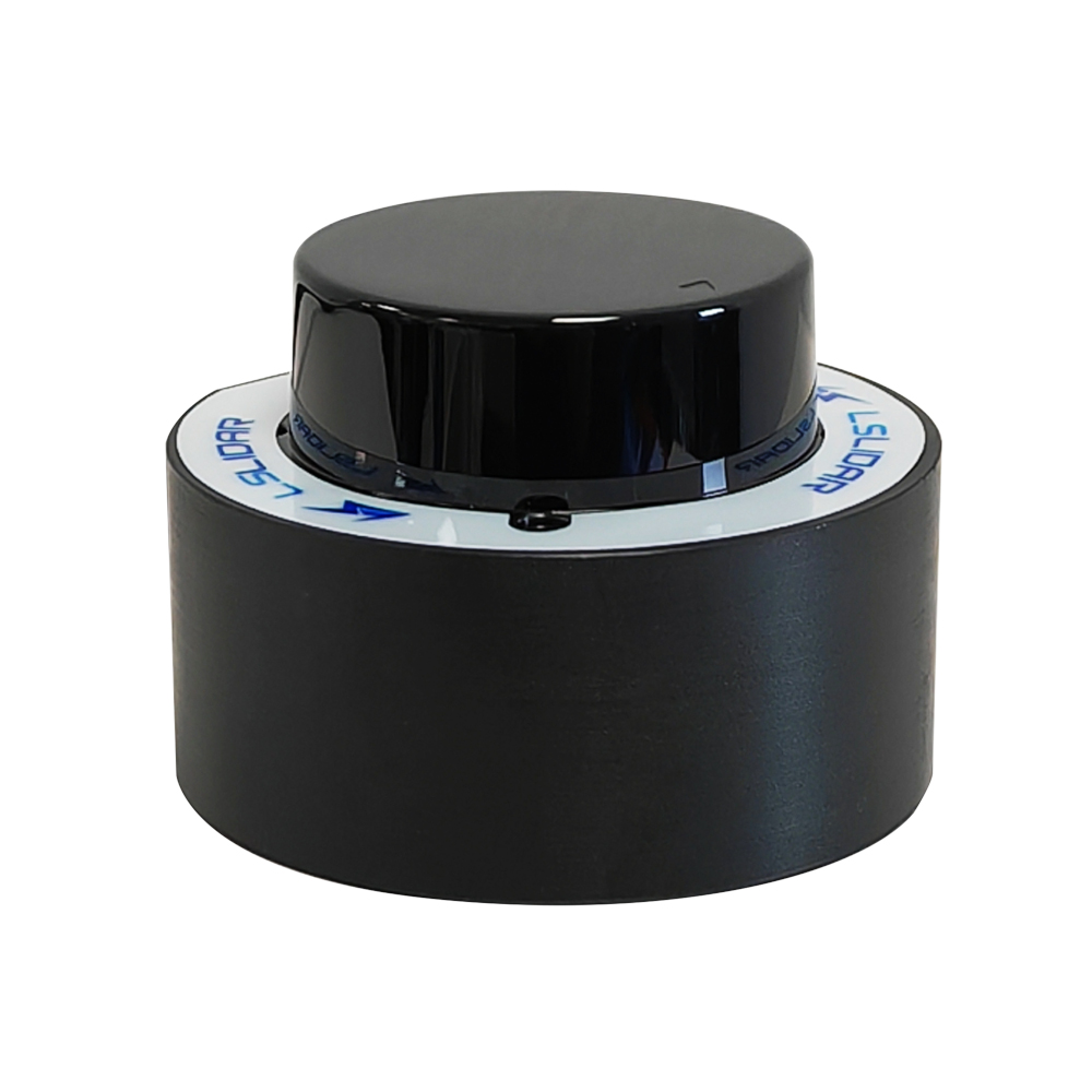
LS Lidar N Series
Get the best price for your setup
Contact us for expected delivery time.
- Fast response
- Expert configuration advice
- No overpaying for features you do not need
The LS Lidar N Series is a compact 360° 2D LiDAR range designed for robot navigation, SLAM mapping and obstacle avoidance. Available as the N10, N10 Plus and N20, these lightweight sensors use 905 nm Time of Flight technology to measure distance, angle and intensity around the complete horizontal environment. Depending on the model, the N Series provides up to 15 m detection range at 70% reflectivity, scanning from 6 to 12 Hz and a housing weighing only around 60 g, making it easy to integrate into service robots, AGVs, cleaning robots and compact autonomous platforms.
LS Lidar N Series Highlights
| LiDAR type | 360° single-line 2D navigation LiDAR |
|---|---|
| Models | N10, N10 Plus and N20 |
| Detection range | Up to 15 m at 70% reflectivity depending on model |
| Scanning angle | 360° |
| Scanning frequency | 6–12 Hz |
| Laser wavelength | 905 nm Class 1 |
| Weight | Approx. 60 g |
Valued customers:










Find RTK Networks
Search NTRIP providers and connect to reliable RTK correction services.
Description
Compact 360 Degree LiDAR for Robot Navigation
The LS Lidar N Series is a family of compact 2D LiDAR sensors developed for robot navigation, SLAM mapping and obstacle avoidance. Available as the N10, N10 Plus and N20, the sensors scan continuously around a complete 360° horizontal plane and provide distance, angle and intensity information that navigation software can use to understand the surrounding environment.
The combination of low weight, compact dimensions and low power consumption makes the N Series particularly suitable for service robots, AGVs, cleaning robots, disinfection robots and other autonomous machines where available installation space is limited.
360 Degree Environmental Scanning
The N Series scans across a full 360° horizontal field of view. This allows a robot to measure objects in every direction from one sensor position rather than only monitoring the area directly ahead.
For indoor navigation, this type of 2D LiDAR can be used to detect walls, furniture, people, shelving and other obstacles around the robot. Navigation or SLAM software can use the measured distances to build a two-dimensional map and determine the robot’s position within that environment.
N10 N10 Plus and N20 Models
The three N Series variants share the same basic 360° Time of Flight architecture but are designed around different priorities. The N10 provides a working range of approximately 0.02 to 12 m at 70% reflectivity and outputs up to 4,500 points per second. It is a compact general-purpose option for indoor robot navigation and obstacle detection.
The N10 Plus extends the specified range to approximately 15 m at 70% reflectivity and increases the point rate to approximately 5,400 points per second, with dual-echo operation allowing up to 10,800 points per second. It also offers stronger resistance to ambient light than the standard N10.
The N20 is focused more strongly on ranging precision and ambient-light performance. It provides approximately ±1.5 cm accuracy from 0 to 8 m and ±3 cm from 8 to 12 m at 70% reflectivity, while retaining the compact dimensions and 360° scanning format of the rest of the series.
Designed for SLAM Mapping
For a mobile robot, knowing the distance to surrounding objects is essential for localisation and route planning. The N Series continuously measures the surrounding environment and provides a two-dimensional profile that SLAM software can compare from one position to the next.
This allows an autonomous platform to build a map while moving and estimate its own position inside that map. In practical applications, this can support automatic route planning, localisation, collision avoidance and return-to-base functions.
Obstacle Detection Around the Complete Robot
Because measurements are collected around the full 360° field of view, the N Series can help a robot detect objects approaching from the side or rear as well as directly in front. This is useful on platforms that manoeuvre in confined areas or frequently change direction.
The sensor itself supplies measurement data rather than making navigation decisions. Obstacle avoidance behaviour is handled by the robot controller or navigation software using the LiDAR data together with wheel encoders, IMUs, cameras or other sensors where required.
Up to 15 Metres Detection Range
Detection range depends on the selected model and target reflectivity. The standard N10 is specified for approximately 12 m at 70% reflectivity, while the N10 Plus reaches approximately 15 m at 70% reflectivity. The N20 provides approximately 12 m at the same target reflectivity.
Reflectivity is important because darker surfaces return less laser energy than bright ones. Actual working distance therefore varies with the material being measured as well as ambient light, installation and environmental conditions.
905 nm Time of Flight Measurement
The N Series uses a 905 nm Class 1 laser and Time of Flight measurement technology. The LiDAR emits a laser pulse toward the environment and measures the time required for the reflected signal to return.
This method allows the sensor to calculate distance repeatedly while its optical system scans around the robot. The resulting data includes distance, measurement angle and reflected intensity, giving navigation software more information about surrounding surfaces than a simple proximity switch.
Adjustable 6 to 12 Hz Scanning
The N10, N10 Plus and N20 operate across a scanning frequency range of approximately 6 to 12 Hz. This allows the system integrator to balance update speed and angular measurement density according to the application.
A higher scan frequency provides more frequent updates as the robot moves, while a lower frequency can provide more closely spaced measurements around each scan depending on the model and configuration.
Very Compact 60 Gram Design
One of the strongest practical advantages of the N Series is its size. Each sensor is approximately 52 mm in diameter and 36.1 mm high with a weight of around 60 g.
This makes the LiDAR particularly easy to embed into small robots. The low profile allows designers to install it into the top or body of an autonomous machine without adding the weight and physical size associated with larger industrial LiDAR sensors.
Low Power Requirements
All N Series variants operate from approximately 5 VDC. Power consumption is around 1 W for the N10, 1.5 W for the N10 Plus and 1.2 W for the N20.
These low power requirements are useful on battery-powered robots because navigation sensors operate continuously whenever the machine is moving. Reducing sensor power consumption helps preserve the available battery capacity for motors, processors and other onboard equipment.
Serial Communication for Embedded Systems
The N Series communicates using a standard asynchronous serial interface. The N10 and N20 use a specified baud rate of 230,400 bps, while the N10 Plus uses 460,800 bps.
Serial communication makes the sensors straightforward to connect to embedded controllers, robot computers and development platforms. Software can process the continuous distance, angle and intensity stream for mapping and navigation functions.
Different Ambient Light Performance by Model
Ambient-light resistance differs significantly between the three models. The standard N10 is specified at approximately 4K lux, while the N20 increases this to approximately 60K lux. The N10 Plus provides the strongest specification at more than 80K lux.
This difference is relevant when selecting a sensor for indoor or outdoor-facing applications. For a robot operating mainly inside buildings, the standard N10 may provide sufficient performance, while applications exposed to brighter daylight can benefit from the stronger anti-light characteristics of the N20 or N10 Plus.
Typical Applications
- Autonomous mobile robots and AGVs
- Service and delivery robots
- Cleaning and disinfection robots
- Indoor SLAM mapping
- Robot localisation and navigation
- 360° obstacle detection
- Compact autonomous machine development
N Series or a 3D LiDAR
The N Series measures within a single horizontal plane and is primarily intended for 2D navigation and obstacle avoidance. For many indoor mobile robots, this is sufficient because walls, furniture, shelving and other major obstacles intersect the sensor’s scanning height.
A multi-channel 3D LiDAR is more appropriate when the system also needs detailed information about object height, uneven terrain or complex three-dimensional surroundings. The N Series is the more compact and data-efficient option when the primary requirement is 360° navigation on relatively level ground.
Choosing an N Series Model from Global GPS Systems
Global GPS Systems supplies LiDAR, GNSS and positioning equipment for robotics, industrial automation, surveying and autonomous systems. When choosing between the N10, N10 Plus and N20, the main considerations are required detection distance, ranging precision and expected ambient-light conditions.
For compact indoor robots, the N10 provides a simple low-power 360° solution. The N10 Plus is useful where additional range and stronger ambient-light resistance are required, while the N20 provides higher short-range precision. Global GPS Systems can help determine which variant best matches the intended robot, controller and working environment.
Datasheets & Manuals
Specifications
LSLiDAR N Series 2D LiDAR Specifications
Product Overview
| Product family | LSLiDAR N Series |
|---|---|
| Models listed by Global GPS Systems | N10, N10 Plus and N20 |
| Product type | Compact 360° single-line 2D LiDAR sensors |
| Measurement principle | Time of Flight (ToF) |
| Laser wavelength | 905 nm |
| Laser safety class | Class I |
| Scanning field of view | 360° |
| Scanning frequency | 6–12 Hz |
| Output data | Distance, azimuth / angle and intensity |
| Primary applications | Robot mapping, localization, navigation, obstacle avoidance, AGV / AMR systems, service robots, cleaning robots, disinfection robots, industrial automation and compact autonomous platforms |
N Series Model Comparison
| Specification | N10 | N10 Plus | N20 |
|---|---|---|---|
| LiDAR type | Single-line 2D LiDAR | Single-line 2D LiDAR | Single-line 2D LiDAR |
| Laser wavelength | 905 nm | 905 nm | 905 nm |
| Laser class | Class I | Class I | Class I |
| Detection range | 0.02–12 m at 70% reflectivity | 0.02–15 m at 70% reflectivity | 0.1–12 m at 70% reflectivity |
| Range accuracy | ±3 cm from 0–6 m; ±4.5 cm from 6–12 m at 70% reflectivity | ±3 cm at 70% reflectivity | ±1.5 cm from 0–8 m; ±3 cm from 8–12 m at 70% reflectivity |
| Repeat accuracy | Not separately specified in the current N10 specification table | Not separately specified in the reviewed N10 Plus specification table | <1 cm |
| Pulse / ranging frequency | 4.5 kHz | 5.4 kHz | 4.5 kHz |
| Scanning frequency | 6–12 Hz | 6–12 Hz | 6–12 Hz |
| Scanning angle | 360° | 360° | 360° |
| Horizontal angular resolution | 0.48°–0.96° | 0.4°–0.8° | 0.8° in the latest manufacturer brochure; earlier documentation specifies variable values |
| Point generation rate | 4,500 points/second | 5,400 points/second | 4,500 points/second |
| Echo mode | Standard single-line ranging | Dual echo | Standard single-line ranging |
| Communication | Asynchronous serial | Asynchronous serial | Asynchronous serial |
| Baud rate | 230,400 bps | 460,800 bps | 230,400 bps |
| Input voltage | 5 VDC (4.75–5.25 V) | 5 VDC (4.75–5.25 V) | 5 VDC (4.75–5.25 V) |
| Published power consumption | 1 W | 1.5 W in product literature; 1.7 W in the V2.0.2 electrical table | 1.2 W |
| Ambient-light resistance | 4,000 lux in current manufacturer documentation | 80,000 lux | 60,000 lux |
| Ingress protection | IPX4 | IPX4 | IPX4 |
| Operating temperature | -10°C to +40°C | -10°C to +40°C | -10°C to +40°C |
| Dimensions | Ø52 × 36.1 mm | Ø52 × 36.1 mm | Ø52 × 36.1 mm |
| Weight | Approximately 60 g | Approximately 60 g | Approximately 60 g |
LSLiDAR N10 Specifications
| Model | N10 |
|---|---|
| Detection range | 0.02–12 m at 70% reflectivity |
| Range accuracy – 0 to 6 m | ±3 cm at 70% reflectivity |
| Range accuracy – 6 to 12 m | ±4.5 cm at 70% reflectivity |
| Pulse repetition frequency | 4.5 kHz |
| Scanning angle | 360° |
| Scanning frequency | 6–12 Hz |
| Angular resolution | 0.48°–0.96° |
| Point generation rate | 4,500 points/second |
| Output data | Distance, angle and intensity |
| Communication interface | Standard asynchronous serial interface |
| Serial baud rate | 230,400 bps |
| Input voltage | 5 VDC |
| Allowed input-voltage range | 4.75–5.25 VDC |
| Power consumption | 1 W |
| Operating temperature | -10°C to +40°C |
| Ingress protection | IPX4 |
| Ambient-light resistance | 4,000 lux in current manufacturer documentation |
| Dimensions | Ø52 × 36.1 mm |
| Weight | Approximately 60 g |
LSLiDAR N10 Plus Specifications
| Model | N10 Plus |
|---|---|
| Detection range | 0.02–15 m at 70% reflectivity |
| Range accuracy | ±3 cm at 70% reflectivity |
| Pulse repetition frequency | 5.4 kHz |
| Scanning angle | 360° |
| Scanning frequency | 6–12 Hz |
| Angular resolution | 0.4°–0.8° |
| Point generation rate | 5,400 points/second |
| Echo capability | Dual echo |
| Output data | Azimuth, distance and intensity |
| Communication interface | Standard asynchronous serial interface / 3.3 V UART logic |
| Serial baud rate | 460,800 bps |
| Input voltage | 5 VDC |
| Allowed input-voltage range | 4.75–5.25 VDC |
| Published power consumption – product literature | 1.5 W |
| Published power consumption – User Manual V2.0.2 electrical table | 1.7 W |
| Operating temperature | -10°C to +40°C |
| Storage temperature | -30°C to +70°C |
| Ambient-light resistance | 80,000 lux; some product literature states greater than 80,000 lux |
| Ingress protection | IPX4 |
| Dimensions | Ø52 × 36.1 mm |
| Weight | Approximately 60 g |
N10 Plus Optical Specifications
| Nominal wavelength | 905 nm |
|---|---|
| Documented wavelength range | 895–915 nm |
| Peak optical pulse power | 25 W |
| Average optical power | 5.5 mW |
| Laser pulse width | 1.6 ns |
| Vertical beam divergence | 11.4 mrad |
| Horizontal beam divergence | 8.4 mrad |
| Laser safety standard | IEC 60825-1:2014, Class I |
LSLiDAR N20 Specifications
| Model | N20 |
|---|---|
| Detection range | 0.1–12 m at 70% reflectivity |
| Range accuracy – 0 to 8 m | ±1.5 cm at 70% reflectivity |
| Range accuracy – 8 to 12 m | ±3 cm at 70% reflectivity |
| Repeat accuracy | <1 cm |
| Output distance resolution | 1 mm |
| Pulse repetition frequency | 4.5 kHz |
| Scanning angle | 360° |
| Scanning frequency | 6–12 Hz |
| Angular resolution – latest manufacturer brochure | 0.8° |
| Angular resolution – 2023 User Manual | 0.48°–0.96° |
| Point generation rate | 4,500 points/second |
| Output data | Azimuth, distance and intensity |
| Communication interface | Standard asynchronous serial interface / 3.3 V UART logic |
| Serial baud rate | 230,400 bps |
| Input voltage | 5 VDC |
| Allowed input-voltage range | 4.75–5.25 VDC |
| Typical operating current | Approximately 240 mA |
| Maximum documented operating current | Approximately 300 mA |
| Power consumption | 1.2 W |
| Operating temperature | -10°C to +40°C |
| Storage temperature | -20°C to +60°C |
| Ambient-light resistance | 60,000 lux |
| Ingress protection | IPX4 |
| Dimensions | Ø52 × 36.1 mm |
| Weight | Approximately 60 g |
N20 Optical Specifications
| Nominal wavelength | 905 nm |
|---|---|
| Documented wavelength range | 895–915 nm |
| Peak optical pulse power | 25 W |
| Average optical power | 0.4 mW |
| Laser pulse width | 2.5 ns |
| Vertical beam divergence | 7 mrad |
| Horizontal beam divergence | 3 mrad |
| Laser safety standard | IEC 60825-1:2014, Class I |
Serial Communication
| Specification | N10 | N10 Plus | N20 |
|---|---|---|---|
| External communication | Asynchronous serial | Asynchronous serial / UART | Asynchronous serial / UART |
| Baud rate | 230,400 bps | 460,800 bps | 230,400 bps |
| UART logic level | Configuration dependent | 3.3 V | 3.3 V |
| Direct embedded-system connection | Supported through the appropriate serial interface | Can interface directly with compatible FPGA, DSP, ARM or microcontroller UARTs | Can interface directly with compatible FPGA, DSP, ARM or microcontroller UARTs |
| RS-232 / RS-422 conversion required | Depends on host system | Not required when connected to a compatible 3.3 V UART | Not required when connected to a compatible 3.3 V UART |
Power Requirements
| Specification | N10 | N10 Plus | N20 |
|---|---|---|---|
| Nominal supply voltage | 5 VDC | 5 VDC | 5 VDC |
| Minimum voltage | 4.75 V | 4.75 V | 4.75 V |
| Maximum voltage | 5.25 V | 5.25 V | 5.25 V |
| Power consumption | 1 W | 1.5 W product specification; 1.7 W in the V2.0.2 electrical table | 1.2 W |
Mechanical Specifications
| Housing diameter | 52 mm |
|---|---|
| Overall height | 36.1 mm |
| Overall size | Ø52 × 36.1 mm |
| Approximate weight | 60 g |
| Motor type | Brushless motor documented for N10 Plus and N20 |
| Form factor | Compact cylindrical rotating 2D LiDAR |
| Installation orientation | Horizontal 360° scanning around the sensor's central axis |
| Thermal installation | Manufacturer documentation recommends mounting the sensor to a structure that provides suitable heat dissipation |
Environmental Specifications
| Specification | N10 | N10 Plus | N20 |
|---|---|---|---|
| Operating temperature | -10°C to +40°C | -10°C to +40°C | -10°C to +40°C |
| Storage temperature | Refer to the applicable production manual | -30°C to +70°C | -20°C to +60°C |
| Ingress protection | IPX4 | IPX4 | IPX4 |
| Ambient-light tolerance | 4K lux in current documentation | 80K lux | 60K lux |
Ingress Protection Notes
| IP rating | IPX4 |
|---|---|
| Water protection | Protected against splashing water according to the applicable IPX4 test classification |
| Dust rating | No numerical dust-protection rating is specified by the IPX4 classification |
| Outdoor exposure | Installation should provide additional enclosure protection where prolonged rain, dust or severe outdoor contamination is expected |
Scanning and Point Data
| Scan type | Single-line 360° horizontal scan |
|---|---|
| Distance output | Supported |
| Azimuth / angle output | Supported |
| Intensity output | Supported |
| Cartesian coordinate conversion | Host software can convert polar distance / angle measurements into X and Y coordinates |
| Real-time point cloud | Supported through manufacturer client / SDK workflows |
| Mapping use | Suitable for 2D SLAM, indoor mapping and robot localization when integrated with compatible processing software |
N10 Plus Connector and Integration
| Sensor connector | A1257H-5P male connector documented in the User Manual |
|---|---|
| Matching connector | A1257WR-S-5P-LCP documented by the manufacturer |
| Power connection | VCC and GND |
| Serial communication | TX and RX |
| Additional control signal | Dedicated additional signal / control connection documented in the N10 Plus wiring interface |
| USB adapter | Optional TTL-to-USB Type-C adapter module documented for development and testing |
Software and Development Support
| Manufacturer PC client | LSLiDAR point-cloud display / configuration software documented for applicable N Series models |
|---|---|
| Live point-cloud display | Supported |
| Parameter configuration | Supported for applicable configurable parameters |
| Sensor testing | Supported through manufacturer tools |
| Point data display | Manufacturer software can display point number / ID, coordinates, azimuth, range, intensity and timestamp where supported |
| Data recording | Supported in applicable manufacturer tools; N20 documentation includes CSV data-saving workflows |
| Linux support | Documented through LSLiDAR SDK / driver packages for applicable N Series revisions |
| ROS support | Manufacturer ROS driver support is documented for N Series integration |
| Windows development support | Documented for applicable N Series SDK and point-cloud client software |
| Current driver requirement | Use the LSLiDAR software / driver package matching the exact sensor model, protocol and firmware revision |
Robot Mapping and Navigation Functions
| 2D mapping | Supported application |
|---|---|
| SLAM | Suitable for integration with compatible 2D SLAM software |
| Localization | Supported application |
| Navigation | Supported application |
| Obstacle detection | Supported application |
| Obstacle avoidance | Supported when integrated with compatible robot-control software |
| Wall / structure detection | Supported through 360° range data |
| Dark-object detection | Manufacturer documentation highlights stable detection of different target colors and reflectivities within specified range limits |
Typical Applications
| Application | Typical N Series Function |
|---|---|
| Service robots | 360° navigation, mapping and obstacle avoidance |
| AGV / AMR | Localization, route navigation and obstacle detection |
| Cleaning robots | Indoor mapping and navigation |
| Disinfection robots | Autonomous indoor navigation and obstacle detection |
| Delivery robots | 2D environmental sensing and localization |
| Industrial robots | Safety-zone sensing, navigation and environmental mapping |
| Drones / UAVs | Short-range obstacle sensing and navigation where size, weight and environmental conditions are suitable |
| Research platforms | Compact 360° LiDAR input for robotics, ROS and SLAM development |
Model Selection Guidance
| Requirement | N10 | N10 Plus | N20 |
|---|---|---|---|
| Longest documented range | 12 m | 15 m | 12 m |
| Highest point rate | 4,500 pts/s | 5,400 pts/s | 4,500 pts/s |
| Best documented near-range precision | ±3 cm | ±3 cm | ±1.5 cm from 0–8 m |
| Highest ambient-light tolerance | 4K lux in current documentation | 80K lux | 60K lux |
| Dual echo | Not specified | Yes | Not specified as the primary operating mode |
| Typical positioning | General compact robot navigation | Longer-range / stronger ambient-light robot sensing | Higher-precision short-range robot navigation |
Manufacturer Documentation Status
| N10 | Current LSLiDAR English product page and current English product brochure documentation available |
|---|---|
| N20 | Documented in the LSLiDAR N20 User Manual and current-generation 2024 manufacturer product literature |
| N10 Plus | Listed by Global GPS Systems and documented in the LSLiDAR N10 Plus User Manual and earlier manufacturer product literature; current production availability should be confirmed |
| N10 manual / brochure range basis | The current N10 specification table states 0.02–12 m at 70% reflectivity with ±3 cm / ±4.5 cm segmented accuracy; this table is used here in preference to conflicting descriptive text found in some document revisions |
| N10 Plus power documentation difference | Manufacturer product literature specifies approximately 1.5 W, while the V2.0.2 User Manual electrical table specifies 1.7 W |
| N20 angular-resolution difference | The latest manufacturer brochure specifies 0.8°, the 2023 User Manual specifies 0.48°–0.96°, and some seller / earlier literature specifies 0.4°–0.8° |
| N10 ambient-light documentation difference | Current manufacturer documentation specifies 4K lux; older product literature contains higher values, so the latest model-specific specification should be used for design purposes |
| Production integration | Electrical interface, protocol, optical performance and driver package should be verified against the datasheet and manual supplied with the exact hardware revision |
Specifications and package contents may vary by configuration, region or manufacturer update. Always check the current configuration before ordering.
Additional information
| Model | N10, N10 Plus, N20 |
|---|
Reviews (0)
Only logged in customers who have purchased this product may leave a review.
FAQ
LS LiDAR N Series FAQ
LS LiDAR N Series & Applications
What is the LS LiDAR N Series?
The LS LiDAR N Series is a family of compact 360° 2D Time of Flight LiDAR sensors designed for robot navigation, positioning, mapping and obstacle avoidance. The range includes the N10, N10 Plus and N20, all of which use a rotating 905 nm laser to measure the distance, angle and reflection intensity of objects surrounding the sensor.
Which models are available in the LS LiDAR N Series?
The N Series consists of the N10, N10 Plus and N20. The N10 provides a measurement range up to 12 m, the N10 Plus extends this to approximately 15 m and increases resistance to strong ambient light, while the N20 provides improved ranging accuracy over much of its 12 m measurement range.
Is the LS LiDAR N Series a 2D or 3D LiDAR?
The N Series consists of 2D LiDAR scanners. Each sensor scans through 360° around one horizontal plane and creates a two-dimensional representation of the surrounding environment. It does not independently produce a full 3D point cloud like a multi-channel 3D LiDAR.
What can the LS LiDAR N Series be used for?
Typical applications include AGV and AMR navigation, service robots, cleaning robots, delivery robots, disinfection robots, industrial automation, obstacle avoidance, indoor mapping, SLAM and other applications that require compact 360° environmental sensing.
Can the LS LiDAR N Series be used for SLAM and robot navigation?
Yes. Robot positioning, navigation and mapping are primary applications of the N Series. The sensor continuously supplies distance and angular measurements around the robot, which compatible SLAM or navigation software can use to build a 2D map, estimate the robot's position and plan movement through its environment.
Can the N Series be used for obstacle avoidance?
Yes. The 360° scan allows a robot or automated machine to detect surrounding objects and determine their distance and direction. Compatible control software can use these measurements for obstacle detection, collision avoidance and path planning.
Range, Accuracy & Scanning Performance
What is the measurement range of the N10, N10 Plus and N20?
The N10 measures from approximately 0.02 to 12 m on a target with 70% reflectivity. The N10 Plus extends the maximum range to approximately 15 m under the same reference conditions. The N20 has a specified range of approximately 0.1 to 12 m at 70% reflectivity. Actual range varies with target reflectivity, ambient light and environmental conditions.
How accurate is the LS LiDAR N10?
The N10 has a specified ranging accuracy of approximately ±3 cm from 0 to 6 m and ±4.5 cm from 6 to 12 m when measuring a target with 70% reflectivity.
How accurate is the LS LiDAR N10 Plus?
The N10 Plus has a specified ranging accuracy of approximately ±3 cm on targets with 70% reflectivity. It is designed to provide a longer maximum range and stronger ambient-light resistance than the standard N10.
How accurate is the LS LiDAR N20?
The N20 has a specified ranging accuracy of approximately ±1.5 cm from 0 to 8 m and ±3 cm from 8 to 12 m when measuring a target with 70% reflectivity. This makes it the highest-accuracy option within the N10, N10 Plus and N20 range for much of its working distance.
What scanning frequency does the LS LiDAR N Series support?
The N10, N10 Plus and N20 support adjustable rotational scanning frequencies from approximately 6 to 12 Hz. At 12 Hz, the sensor completes approximately 12 full 360° scans every second, allowing navigation software to respond rapidly to changes in the surrounding environment.
How many measurement points does the N Series generate?
The N10 generates approximately 4,500 measurement points per second and the N10 Plus approximately 5,400 points per second. The horizontal angular resolution varies with the selected rotation frequency, with the N10 specified at approximately 0.48° to 0.96° and the N10 Plus and N20 at approximately 0.4° to 0.8°.
Laser, Data & System Integration
How does the LS LiDAR N Series measure distance?
The N Series uses Time of Flight technology. The sensor emits short laser pulses and measures the time required for the reflected light to return from surrounding objects. The measured distance is combined with the rotational angle of the sensor to determine where each detected point is located around the LiDAR.
What data does the LS LiDAR N Series output?
The N Series outputs distance, angle and reflection-intensity information. These measurements can be converted into X and Y coordinates by navigation, SLAM or mapping software to create a two-dimensional representation of the surrounding environment.
What laser wavelength does the LS LiDAR N Series use?
The N10, N10 Plus and N20 use a 905 nm near-infrared laser. This wavelength is commonly used in compact Time of Flight LiDAR sensors for robotics, navigation and industrial obstacle-detection applications.
Is the LS LiDAR N Series eye-safe?
Yes. The N Series is specified as a Class 1 laser product in accordance with IEC 60825-1 requirements. The sensor should still be installed and operated according to the manufacturer's laser-safety instructions and should not be disassembled or optically modified.
How does the N Series connect to a robot or computer?
The N Series uses a 3.3 V asynchronous serial communication interface. The N10 and N20 use a baud rate of 230400 bps, while the N10 Plus uses 460800 bps. An optional TTL-to-USB adapter can be used to connect the LiDAR to a computer through USB for development and testing.
Does LS LiDAR provide software or ROS support for the N Series?
Yes. LS LiDAR provides Windows point-cloud display and configuration software as well as ROS support for compatible Linux systems. These development tools can be used for visualising scan data, configuring supported parameters, testing the sensor and integrating LiDAR measurements into robotics applications.
Power, Environment & Installation
What power supply does the LS LiDAR N Series require?
The N10, N10 Plus and N20 operate from a nominal 5 VDC supply, with a specified range of approximately 4.75 to 5.25 VDC. Typical power consumption is approximately 1 W for the N10, 1.5 W for the N10 Plus and 1.2 W for the N20.
How well does the N Series work in bright ambient light?
Ambient-light resistance differs between models. The N10 is specified for approximately 4,000 lux, the N20 for approximately 60,000 lux and the N10 Plus for more than 80,000 lux. The N10 Plus is therefore particularly suitable when stronger ambient-light resistance is important. Actual performance also depends on target reflectivity and installation conditions.
Is the LS LiDAR N Series waterproof?
The N10, N10 Plus and N20 have an IPX4 rating. This provides protection against splashing water but does not make the sensors suitable for immersion or direct high-pressure water exposure. Outdoor installations should therefore provide additional environmental protection where required.
What temperature range can the LS LiDAR N Series operate in?
The N10, N10 Plus and N20 have a specified operating temperature range of approximately -10°C to +40°C. The sensor should be installed with suitable ventilation and heat dissipation and operated within the environmental limits specified by the manufacturer.
How large and heavy are the N10, N10 Plus and N20?
All three models are extremely compact, measuring approximately 52 mm in diameter and 36.1 mm high. Each sensor weighs approximately 60 g, making the N Series suitable for small robots, AGVs and other platforms where installation space and payload are limited.
What should be considered when mounting an N Series LiDAR?
The sensor should be mounted rigidly with an unobstructed 360° horizontal view at the height where obstacles need to be detected. The optical window should remain clean, the mounting base should provide suitable heat dissipation and the sensor should be positioned so that parts of the robot or mounting structure do not unnecessarily block the scan plane.
 GPS & GNSS
 Total Stations
 Data collectors
 Software
 Correction services
 Machine control
 External radio
 Marine
 Accessories
Reviews
There are no reviews yet