

GNSS
GNSS Surveying Methods: Exploring Accuracy and Techniques
Global Navigation Satellite Systems (GNSS) have revolutionized surveying and mapping by providing accurate positioning data. GNSS surveying methods employ satellite signals to determine precise coordinates, enabling professionals in various industries to carry out accurate measurements. In this article, we will delve into the different methods of GNSS measurement, compare their accuracy, explore surveying techniques, highlight the advantages of Real-Time Kinematic (RTK) over Differential Global Positioning System (DGPS), and identify the most accurate surveying tools.
What are the different methods of GNSS measurement?
Single Point Positioning (SPP)
Single Point Positioning is the most basic form of GNSS surveying, where a single receiver collects satellite signals to determine its position. However, SPP has limitations in terms of accuracy, typically within a few meters due to factors like atmospheric interference and satellite geometry.
Differential Positioning (DGPS)
Differential Positioning improves accuracy by using a reference station with known coordinates. By comparing the reference station’s position with the receiver’s measurements, DGPS can eliminate errors caused by atmospheric disturbances, clock inaccuracies, and satellite orbit errors, achieving sub-meter to decimeter accuracy.
Real-Time Kinematic (RTK)
RTK is a surveying method that provides high-precision real-time positioning. It employs a base station and one or more rovers to receive GNSS signals. The base station receives signals from satellites and transmits correction data to the rovers, allowing them to compute precise coordinates. RTK can achieve centimeter-level accuracy, making it suitable for applications that demand high precision.
Post-Processing Kinematic (PPK)
PPK involves recording raw GNSS data during the survey and processing it after data collection. By using a base station or virtual reference station data, PPK calculates the precise coordinates of the survey points. PPK can achieve similar accuracy to RTK, but it requires additional post-processing time.
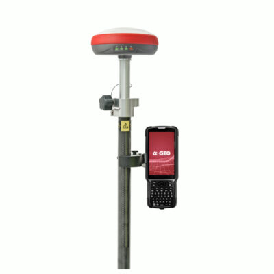
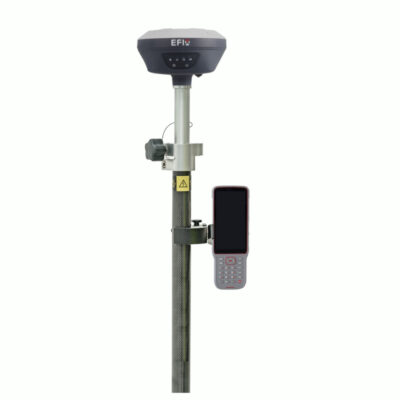
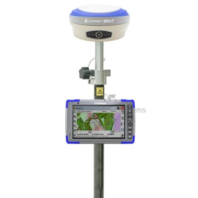
Some popular GNSS receivers that support rtk


GPS & GNSS
Which method of GNSS surveying is more accurate?
Accuracy of Single Point Positioning (SPP)
SPP is the least accurate method among the four. It typically provides accuracy within several meters, making it suitable for applications that do not require high precision, such as basic mapping or positioning in open areas.
Accuracy of Differential Positioning (DGPS)
DGPS improves accuracy significantly, achieving sub-meter to decimeter-level precision. It is widely used in applications like land surveying, construction, agriculture, and navigation where accuracy within a few centimeters is essential.
Accuracy of Real-Time Kinematic (RTK)
RTK is the most accurate GNSS surveying method, capable of achieving centimeter-level precision in real-time. Its high accuracy makes it ideal for applications like precision agriculture, construction staking, and cadastral surveys.
Accuracy of Post-Processing Kinematic (PPK)
PPK can achieve similar accuracy to RTK, providing centimeter-level precision. However, since PPK involves post-processing, it may require additional time to obtain accurate results compared to RTK.

How do I survey with GNSS?
Equipment and Tools Required
To conduct GNSS surveying, you will need a GNSS receiver (rover), GNSS antennas, a data collector or mobile device, and surveying accessories such as tripods, poles, and cables.
Preparation and Setup
Before starting the survey, ensure that your equipment is properly calibrated, batteries are fully charged, and you have the necessary software and firmware updates. Set up the base station and rover antennas at known control points or benchmarks, and establish a reliable communication link between them.
Collecting GNSS Data
Once the setup is complete, collect GNSS data by recording measurements at desired survey points. Ensure you have good satellite reception and maintain a stable position while recording data. Collect additional attributes if required, such as point descriptions or photographs.
Post-Processing Data
Depending on the surveying method used, post-processing may be necessary. If utilizing RTK, real-time corrections are applied during the survey. For PPK or other methods, transfer the collected data to a computer and process it using GNSS software. This step involves applying corrections, validating data, and generating accurate coordinate results.
Why is RTK more accurate than DGPS?
Real-Time Corrections
RTK uses real-time corrections transmitted from the base station to the rover. These corrections account for various errors in satellite signals, such as ionospheric and tropospheric delays, resulting in highly precise positioning. DGPS, on the other hand, relies on post-processing differential corrections, which may introduce additional errors due to the time delay.
Elimination of Base Station Requirements
RTK allows for quick setup and surveying without the need for a physical base station. This eliminates the challenges associated with setting up and maintaining a reference station, making RTK more convenient and cost-effective compared to DGPS.
Reduced Latency and Increased Precision
RTK provides real-time positioning with minimal latency, enabling surveyors to monitor and adjust their measurements on-site. This immediate feedback allows for increased accuracy and reliability. DGPS, on the contrary, may have longer latency due to the post-processing requirements, which can limit its applicability in time-sensitive applications.
Correction services
Conclusion
GNSS surveying methods offer a wide range of accuracy levels and techniques to meet the needs of various applications. While SPP provides basic positioning, DGPS improves accuracy, and RTK and PPK offer centimeter-level precision. RTK stands out as the most accurate method due to its real-time corrections, convenience, and reduced latency. High-end GNSS receivers with multi-constellation and multi-frequency capabilities, integrated sensor systems, and advanced data processing software contribute to achieving the highest accuracy in surveying tasks. By understanding the different GNSS surveying methods and selecting the appropriate tools, professionals can ensure accurate and reliable results for their projects.