
GNSS
Enhancing GNSS Surveying with Augmented Reality: A Revolutionary Stakeout Technique
Augmented Reality (AR) has emerged as a game-changing technology, revolutionizing various industries by blending virtual elements with the real world. In the field of Global Navigation Satellite System (GNSS) surveying, AR has paved the way for remarkable advancements, particularly in stakeout operations. In this article, we will explore how AR is transforming GNSS surveying stakeouts, its benefits, and the key considerations for implementing this innovative technique.
Understanding GNSS Surveying Stakeouts
GNSS surveying stakeouts involve the process of marking specific points or features on the ground based on the coordinates obtained from a GNSS receiver. Traditionally, this process required surveyors to use handheld devices or traditional surveying equipment to physically locate and mark the desired positions. However, with the advent of AR technology, stakeouts have become more efficient and accurate.
In the pictures below you can see how easy it is to navigate to a known point with ar technology
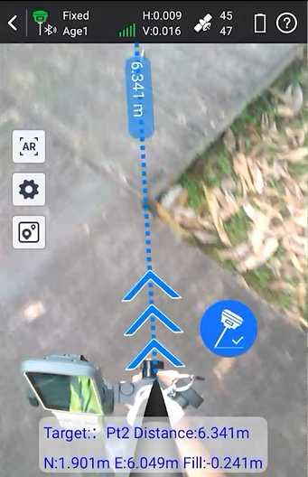
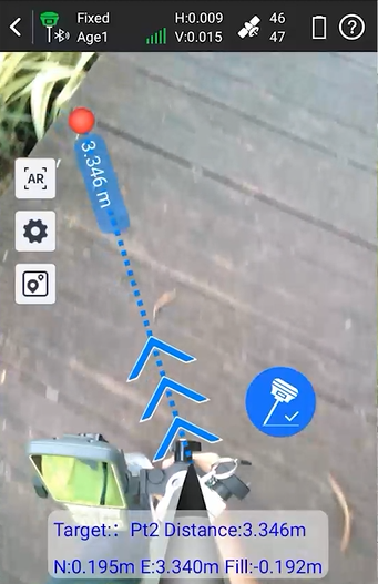
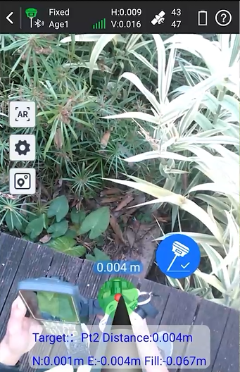
The equipment used in the pictures above are the South Insight V2 GNSS receiver, the South H6 data collector and the South SurvStar software. You can buy this equipment as a complete rover set so you have everything you need to start surveying. Click on the button on the right to check out the set.
The South Insight V2 utilizes the latest technology, transmitting image data and calibration to a data controller, with which users can obtain real-time images that navigate them to the correct position. Moreover, the IMU calibration enables users to stake out without leveling the bubble, saving more time and significantly boosting productivity. Visualization makes stakeout simpler than ever before.
How AR Enhances Stakeout Operations
-
Real-time Visualization: AR enables surveyors to visualize the stakeout points or targets overlaid on the real-world view captured through the camera of a mobile device or a specialized AR headset. This visual feedback empowers surveyors to precisely position themselves and guide them to the target locations.
-
Improved Accuracy: AR stakeout techniques allow surveyors to leverage the accuracy of GNSS positioning while simultaneously benefiting from the visual confirmation provided by AR overlays. This combination reduces the likelihood of errors and ensures that stakeout points are accurately marked.
-
Increased Efficiency: By eliminating the need for manual calculations and constant referencing to maps or plans, AR stakeouts streamline the process and reduce the time required to complete stakeout operations. Surveyors can work more efficiently, minimizing errors and improving productivity.
Benefits of AR Stakeouts in GNSS Surveying
-
Enhanced Spatial Understanding: AR provides an intuitive and immersive experience, enabling surveyors to gain a better understanding of the surveying site’s layout and context. This improved spatial awareness contributes to more informed decision-making during stakeout operations.
-
Minimized Rework: The real-time visualization capabilities of AR stakeouts help identify potential issues or conflicts early on, reducing the chances of costly rework. Surveyors can assess the feasibility of stakeout points and make adjustments on-site, saving time and resources.
-
Training and Collaboration: AR stakeouts facilitate efficient training of new surveyors by providing a visual overlay of stakeout points and procedures. Additionally, remote collaboration becomes easier as experienced surveyors can guide and support on-site personnel using AR-enabled communication tools.
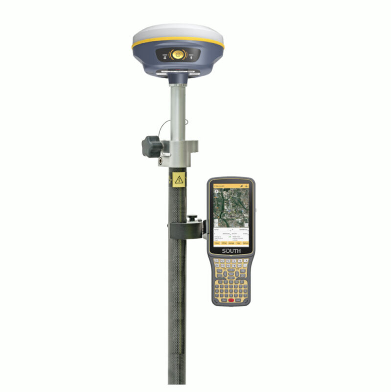
some popular Gnss receivers with ar technology


Implementing AR Stakeouts: Key Considerations
-
Hardware and Software Selection: Choosing the right AR hardware, such as AR-capable GNSS receivers, is crucial. Compatibility with the selected GNSS receiver and reliable AR software applications are equally important considerations.
-
Data Integration: Seamless integration of GNSS surveying data with AR software is essential for accurate overlaying of stakeout points. Ensuring proper synchronization and alignment between the real-world view and virtual overlays is crucial for optimal results.
-
User Training and Familiarization: Adequate training is vital to ensure surveyors are proficient in operating AR-enabled stakeout systems. Familiarity with AR interfaces, gestures, and tools will help maximize the benefits and minimize potential errors during stakeout operations.
Conclusion
Augmented Reality is transforming the field of GNSS surveying stakeouts, providing surveyors with unprecedented visualization capabilities and enhancing the accuracy and efficiency of operations. The combination of GNSS positioning data and AR overlays enables real-time decision-making, minimizing errors, and optimizing productivity. As the technology continues to evolve, the integration of AR into GNSS surveying stakeouts will undoubtedly unlock further possibilities and shape the future of the industry. Embracing this innovative technique promises to revolutionize surveying practices, ultimately benefitting professionals and clients alike.