


Satlab Eyr
This product is available
Get the best price for your setup
Contact our experts for the best possible price and configuration.
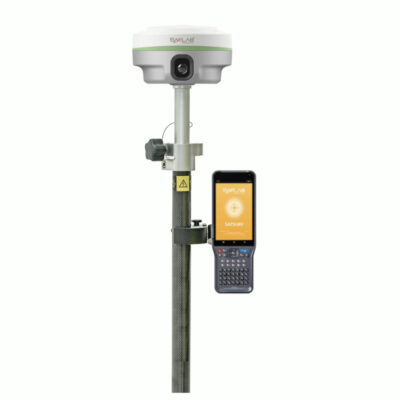
Experience unmatched precision and efficiency with the Satlab Eyr, a high-performance RTK GNSS receiver designed for land surveying and construction. Featuring dual cameras for AR live-view stakeout, robust satellite tracking, and superior tilt compensation, the Satlab Eyr RTK GNSS Receiver ensures accurate, contact-free measurements. Paired with advanced software and multi-protocol connectivity, it’s the ultimate GNSS receiver for land surveying and a dependable GPS set for construction.
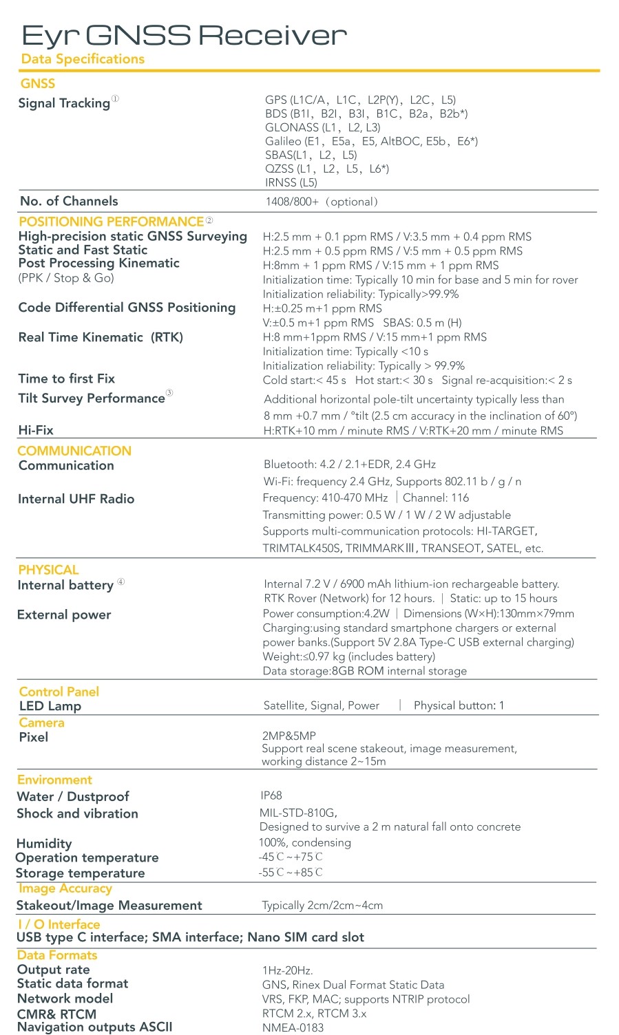
| ✅ Channels | 1408 |
| ✅ IMU Tilt Sensor | 60° |
| ✅ Internet Modem | 4G |
| ✅ UHF Radio | 410 – 470MHz |
| GPS | L1C/A, L1C, L2P(Y), L2C, L5 |
| GLONASS | L1, L2, L3 |
| GALILEO | E1, E5a, E5b, E6, AltBOC |
| BEIDOU | B1I, B2I, B3I, B1C, B2a, B2b |

Valued customers:


Find RTK Networks
Search NTRIP providers and connect to reliable RTK correction services.
Description
Satlab Eyr: The Ultimate RTK GNSS Receiver for Precision and Efficiency
Revolutionize Land Surveying and Construction with Satlab Eyr
The Satlab Eyr is a cutting-edge RTK GNSS receiver designed to transform how professionals approach land surveying and construction tasks. Engineered with dual cameras, robust satellite tracking, and superior anti-jamming technology, the Satlab Eyr RTK GNSS Receiver ensures precise measurements and efficient operations. Whether you’re in the field conducting land surveys or managing complex construction projects, the Satlab Eyr is the perfect solution for enhancing accuracy and productivity.
Key Features and Benefits
Dual Camera System for Effortless Stakeout and Measurement
The Satlab Eyr features a 5-megapixel rearview camera and a 2MP bottom camera, enabling seamless and contact-free measurements. Its AR live-view stakeout function, powered by the bottom camera, delivers 2cm accuracy, saving you time and effort in reaching stakeout points. This capability makes it the ideal GNSS receiver for land surveying and construction applications.
Superior Satellite Tracking and Anti-Jamming Capabilities
Equipped with SatLab’s self-developed antenna and an advanced motherboard supporting up to 1408 channels, the Satlab Eyr ensures stable operation even in challenging environments. Its enhanced anti-jamming technology guarantees high-quality satellite data collection, providing unmatched reliability for land surveying equipment.
Integrated Multi-Protocol Radio for Versatile Connectivity
The built-in multi-protocol transceiver radio allows the Satlab Eyr to transmit and receive differential data across various RTK radio data links. With an impressive operating range of 7km—and even farther under ideal conditions—this GNSS receiver with IMU tilt sensor offers flexible and dependable communication for any project.
Advanced Software Integration
Paired with SatLab Satsurv software, the Satlab Eyr RTK GNSS Receiver delivers an intuitive and powerful field surveying experience. Additionally, the Eyr’s image data seamlessly integrates with popular 3D modeling tools like ContextCapture, DPSmart, and Pix4D, making it the ultimate companion for UAV operations and detailed site analysis.
Why Choose Satlab Eyr?
- Unmatched Precision: Achieve 2-4 cm accuracy with real-time coordinate capture.
- Efficiency Boost: Save time with AR live-view stakeout and non-contact measurements.
- Reliability: Perform flawlessly in various field conditions with advanced anti-jamming technology.
- Versatility: Ideal for both land surveying equipment needs and GPS set for construction projects.
Datasheets & Manuals
Datasheets and manuals
Reviews (0)
Only logged in customers who have purchased this product may leave a review.
Reviews
There are no reviews yet