
 GPS & GNSS
 Lidar scanning
 Total Station

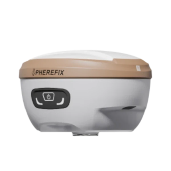

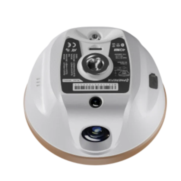
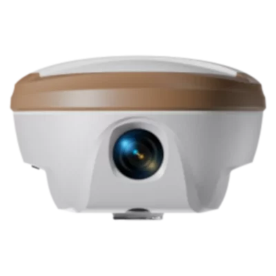


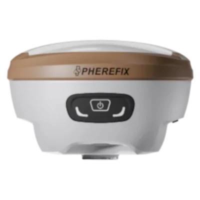
Spherefix SP35Pro GNSS Receiver with AR Stakeout and Photogrammetry
Currently unavailable
Get the best price for your setup
Contact us for expected delivery time.
This product is end of life


Valued customers:










Find RTK Networks
Search NTRIP providers and connect to reliable RTK correction services.
Description
Visual RTK surveying for demanding fieldwork
The Spherefix SP35Pro is a professional multi-band RTK GNSS receiver designed for surveyors, construction teams, civil engineers and GIS professionals who need accurate coordinates without slowing down field operations. In addition to conventional point surveying, the receiver combines inertial tilt measurement, photogrammetry and augmented-reality stakeout in one compact instrument.
This combination is especially useful when a survey point is difficult to reach safely or when a large number of design points must be set out across a busy site. Instead of relying only on a vertical survey pole and directional values on a controller screen, operators can use visual information to support measurement and stakeout work.
Photogrammetry for inaccessible points
The SP35Pro includes a dedicated 1/2.6-inch wide-angle photogrammetry camera. Together with the receiver’s positioning data, inertial sensors and compatible Android field controller, this allows the operator to capture visual data and determine points that may be inconvenient or unsafe to occupy directly with the pole.
In practical fieldwork, photogrammetry can help when collecting building edges, façades, corners, roadside features, trenches and other objects where placing the pole tip directly on the required point is difficult. It adds flexibility to normal RTK surveying without requiring a separate camera system for every visual measurement task.
AR real-scene stakeout
A separate ultra-wide-angle camera supports AR real-scene stakeout. The stakeout direction and target position can be shown over a live view of the surroundings, giving the operator a clearer visual route towards the point.
This is useful for construction layout, utility marking and general setting-out work, particularly when conventional arrows and distance values are difficult to interpret. By connecting digital stakeout information to the actual site view, the system can reduce unnecessary movement and make it easier to approach the correct position.
Measure with the pole tilted
The integrated IMU supports tilt compensation through an angle of up to 60°, with a stated positioning error of less than 2 cm within that range. The pole therefore does not have to remain perfectly vertical for every observation.
Tilt surveying is valuable beside walls, under vegetation, near parked machinery and around other obstructions where the survey pole cannot be held directly above the point. It also makes routine topographic collection more comfortable by reducing the time spent levelling the pole for each measurement.
Full-constellation multi-band GNSS tracking
The receiver uses 1408 tracking channels and supports signals from GPS, GLONASS, BeiDou, Galileo, QZSS, SBAS and NavIC. Tracking multiple constellations and frequencies gives the receiver access to a larger number of satellites, which can improve positioning availability where part of the sky is obstructed.
Specified RTK accuracy is ±(8 mm + 1 ppm) horizontally and ±(15 mm + 1 ppm) vertically under suitable operating conditions. The receiver supports RTCM 3.x correction data and an update rate of up to 20 Hz, making it suitable for detailed topographic surveys, construction positioning, site control and GIS asset collection.
Network RTK and local base workflows
The SP35Pro can be configured as a rover, base receiver or static GNSS receiver. Integrated 4G enables direct access to compatible NTRIP and CORS correction services where mobile coverage and an RTK network are available. Wi-Fi and Bluetooth provide connections to field controllers, smartphones and tablets.
For projects without dependable mobile data coverage, the built-in 410–470 MHz radio can transmit or receive corrections in a local base-and-rover setup. Selectable 0.5 W and 1.5 W output options and support for several common radio protocols provide flexibility when integrating the receiver into an existing equipment fleet.
- Rover operation with network or radio corrections
- Base operation for transmitting local correction data
- Static data collection for post-processing workflows
Built for mobile survey crews
At approximately 770 g, the SP35Pro is light enough for frequent movement between survey points. Its housing combines a magnesium-alloy shell with an ABS/PC top cover, providing a balance between low weight and field durability.
The receiver is IP68 rated and specified for operating temperatures from −30°C to +65°C. It is also designed to withstand a 2 m pole drop at room temperature. These characteristics make it suitable for everyday use on construction sites, roads, agricultural land and general outdoor survey projects.
The internal 7.4 V 6500 mAh battery provides more than 16 hours of typical rover operation using GSM. USB Power Delivery charging is supported, allowing crews to recharge the receiver with compatible field power equipment.
Suitable applications
The Spherefix SP35Pro is suited to cadastral and topographic surveying, construction stakeout, earthworks, road projects, utility mapping, GIS asset collection and general civil-engineering measurement. Its visual functions are particularly relevant to teams that regularly encounter inaccessible points or carry out intensive stakeout work.
Configuration and support from Global GPS Systems
Global GPS Systems can help buyers select a suitable SP35Pro configuration for network RTK, base-and-rover operation, photogrammetry or AR stakeout. The correct controller, software, radio frequency and accessories depend on the intended country, correction service and field workflow, so these details should be confirmed before deployment.
For organisations comparing GNSS receivers, the SP35Pro is a strong option when visual measurement and camera-guided stakeout are more important than laser distance measurement. Survey teams that specifically require an integrated laser should compare it with the separate Spherefix SP35 model.
Datasheets & Manuals
Datasheets and manuals
Specifications
SphereFix SP35Pro GNSS Receiver Specifications
Product Overview
| Product type | Multi-frequency, multi-constellation GNSS RTK receiver |
|---|---|
| Model | SP35Pro |
| Primary applications | RTK surveying, topographic data collection, construction layout, point stakeout, tilt surveying, static surveying, photogrammetry and AR real-scene stakeout |
| Integrated technologies | Multi-constellation GNSS, high-precision inertial navigation, photogrammetry, AR real-scene stakeout, cellular communication, Wi-Fi, Bluetooth, NFC and UHF/LoRa radio |
| Receiver operating modes | Rover, base and static modes |
Hardware and Operating System
| Processor architecture | ARM Cortex-A7 |
|---|---|
| Operating system | Linux |
| GNSS engine | High-precision, all-frequency positioning module |
| GNSS channels | 1408 channels |
| Internal storage | 8 GB |
| Integrated IMU | High-precision inertial navigation module with tilt compensation |
GNSS Satellite Tracking
| Constellation | Supported Signals | Notes |
|---|---|---|
| GPS | L1C/A, L1C, L2P(Y), L2C, L5 | Multi-frequency tracking |
| GLONASS | L1, L2, L3 | Multi-frequency tracking |
| BeiDou | B1I, B2I, B3I, B1C, B2a, B2b | Supports PPP-B2b |
| Galileo | E1, E5a, E5b, E6 | Supports PPP-E6 |
| QZSS | L1, L2, L5 | Supported |
| SBAS | L1 | Supported |
| NavIC (IRNSS) | L5 | Latest compatible firmware may be required |
GNSS Data and Performance
| Data format | NMEA-0183 |
|---|---|
| Correction input/output protocol | RTCM 3.x |
| Data update frequency | Up to 20 Hz |
| Signal recapture time | Less than 1 second |
| Cold boot time | Less than 40 seconds |
| RTK initialization time | 10 seconds or less |
| Internal noise level | 1 mm or less |
| Phase-center offset | 2.5 mm or less |
| Time accuracy | 20 ns RMS |
| Speed accuracy | 0.03 m/s RMS |
Positioning Accuracy
| Positioning Mode | Horizontal Accuracy | Vertical Accuracy |
|---|---|---|
| Single-point positioning | 1.5 m RMS | 2.5 m RMS |
| DGPS | 0.4 m RMS | 0.8 m RMS |
| RTK | ±(8 mm + 1 ppm) RMS | ±(15 mm + 1 ppm) RMS |
| Static surveying | ±(2.5 mm + 1 ppm) RMS | ±(5 mm + 1 ppm) RMS |
| AR stakeout | ±(8 mm + 1 ppm) | ±(15 mm + 1 ppm) |
Tilt Compensation and Inertial Measurement
| Tilt compensation range | Up to 60° |
|---|---|
| Tilt compensation accuracy | Less than 2 cm within a 60° tilt range |
| Pole levelling requirement | Measurements can be collected without precisely levelling the survey pole when tilt compensation is active |
| Integrated functions | IMU-assisted point measurement, photogrammetry and AR real-scene stakeout |
| Laser tilt surveying accuracy | Three-dimensional error of 2.5 cm or less within a 5 m distance, as listed in the manufacturer datasheet |
AR Real-Scene Stakeout Camera
| Function | Camera-assisted AR real-scene point stakeout |
|---|---|
| Sensor size | 1/2.8 inch |
| Aperture | f/2.5 |
| Image resolution | 1920 × 1080 pixels |
| Field of view | 69.3° ±3° |
| Lens distortion | Less than 0.38% |
| Stakeout display | Real-time visual guidance overlaid on the live camera view |
Photogrammetry Camera
| Photogrammetry support | Supported |
|---|---|
| Sensor size | 1/2.6 inch |
| Focal length | 3.27 mm |
| Aperture | f/2.8 |
| Image resolution | 1920 × 1080 pixels |
| Diagonal angle of view | 83° |
| Horizontal angle of view | 72° |
| Vertical angle of view | 51° |
| Lens distortion | Less than 0.5% |
| Operating connection | Photogrammetry workflow supported through a Wi-Fi connection to a compatible controller |
Wireless Connectivity
| Bluetooth | BR, EDR and BLE |
|---|---|
| NFC | Supported |
| Wi-Fi | IEEE 802.11 b/g/n/ac |
| Wi-Fi hotspot | Supported for connection to a controller, computer, smartphone or tablet |
| Web interface | Built-in Web UI for status monitoring, operating-mode configuration, data management, firmware updates and device settings |
| Cellular connectivity | Integrated 4G full-network modem with LTE, WCDMA and GSM support |
| SIM support | Integrated SIM-card slot |
Cellular Network Bands
| Network Type | Supported Bands | Technology |
|---|---|---|
| LTE FDD | B1, B2, B3, B4, B5, B7, B8, B18, B19, B20, B25, B26, B28 | 4G |
| LTE TDD | B38, B39, B40, B41 | 4G |
| WCDMA | B1, B2, B4, B5, B6, B8, B19 | 3G |
| GSM | B2, B3, B5, B8 | 2G |
Integrated Data Radio
| Radio type | Integrated transceiver radio with LoRa support |
|---|---|
| Frequency range | 410–470 MHz |
| Transmit power | Selectable 0.5 W or 1.5 W |
| Air baud rates | 4800, 9600 and 19200 bps |
| Supported radio protocols | TRIMTALK, TRIMMK3, SOUTH, TRANSEOT, SATEL and LoRa |
| Radio antenna | External 450–470 MHz terminal antenna supplied with the standard receiver package |
Data Links and Correction Sources
| Bluetooth data link | Supported |
|---|---|
| Wi-Fi data link | Supported |
| Internal cellular network | Supported |
| Internal radio | Supported |
| External radio | Supported |
| CORS/NTRIP operation | Supported through a connected controller or the receiver’s integrated network modem |
| Base access-point operation | Supported for transmitting corrections from a configured base receiver |
Surveying and Software Functions
| Point surveying | Supported |
|---|---|
| Tilt surveying | Supported |
| Static data collection | Supported |
| Point stakeout | Supported |
| AR real-scene stakeout | Supported through Wi-Fi with a compatible controller |
| Photogrammetry | Supported through Wi-Fi with a compatible high-performance Android controller |
| Localization | Supported |
| Point calibration | Supported |
| Point database | Supported |
| Project import and export | Supported through the SphereFix field software |
| Raw data recording | Supported in compatible rover, base and static configurations |
| Firmware management | Local firmware upgrades supported through the receiver Web UI |
| Remote assistance | Supported through the receiver management interface |
Battery and Charging
| Battery type | Integrated rechargeable lithium battery |
|---|---|
| Battery configuration | 7.4 V, 6500 mAh, 2P2S |
| Typical operating time | More than 16 hours in typical rover operation using GSM |
| Charging interface | USB Type-C |
| USB Power Delivery input | 12 V / 2 A |
| USB DCP input | 5 V / 3 A |
| Fast-charging support | USB PD charging supported |
| Maximum supplied charger rating | 33 W PD adapter |
| Typical full charging time | Approximately 4 hours with a compatible charger |
| Charging indicator | Red while charging; green when fully charged |
| Battery-level indication | Battery level displayed through receiver indicator lights after a brief press of the power button |
Environmental Protection
| Ingress protection | IP68 |
|---|---|
| Operating temperature | -30°C to +65°C |
| Storage temperature | -40°C to +85°C |
| Drop resistance | Designed to withstand a 2 m pole drop at room temperature |
| Dust resistance | Protected against dust ingress in accordance with the IP68 enclosure rating |
| Water resistance | Protected against water ingress in accordance with the IP68 enclosure rating |
| Field construction | Rugged, lightweight housing designed for professional outdoor surveying |
Physical Specifications
| Dimensions | Ø134 × 86 mm |
|---|---|
| Diameter | 134 mm |
| Height | 86 mm |
| Weight | 770 g or less |
| Housing material | Magnesium-alloy shell with ABS/PC plastic top cover |
| Design | Compact, lightweight receiver with an integrated battery, cameras, IMU, cellular modem and data radio |
Controls, Indicators and Interfaces
| Power control | Single multifunction power button |
|---|---|
| Power-on operation | Press and hold for approximately 3 seconds while the receiver is off |
| Power-off operation | Press and hold for approximately 3 seconds while the receiver is on |
| Battery check | Briefly press the power button for approximately 1 second |
| Status indicators | Satellite, differential-data, Bluetooth, radio, network, battery and charging status indicators |
| USB interface | USB Type-C for charging and data connection |
| Radio antenna connection | External UHF radio antenna interface |
| SIM interface | Internal SIM-card slot beneath a protective cover |
Web User Interface
| Access method | Connect a computer, smartphone or tablet to the receiver’s Wi-Fi hotspot and open the Web UI in a browser |
|---|---|
| Default Web UI address | 10.10.10.10 |
| GNSS status display | Time, solution quality, latitude, longitude, height and satellite status |
| Skyplot | Displays satellite trajectories, satellite names, health, elevation and azimuth |
| Data-stream monitoring | Supported |
| Mode configuration | Rover, base and static settings |
| File management | View and download receiver files and recorded raw data |
| Device information | Displays serial number, hardware, GNSS module, modem and firmware information |
| Firmware upgrades | Local firmware installation and receiver restart supported |
| Device administration | Registration, restart, shutdown, reset, logging and diagnostic functions |
Standard Package Contents
| Item | Quantity | Notes |
|---|---|---|
| SphereFix SP35Pro geodetic GNSS receiver | 1 | Standard |
| 450–470 MHz radio terminal antenna | 1 | Model AT0038; standard |
| CC data cable | 1 | Model L0602-1; standard |
| 33 W EU USB PD power adapter | 1 | Model CG0004; regional plug configuration may vary |
| SP35Pro yellow PP transport case | 1 | Standard |
| USB power adapter | 1 | Model CG0003; standard |
| USB 3.0 Type-C data cable | 1 | Model L0602-2; standard |
Optional Accessories
| Item | Quantity | Notes |
|---|---|---|
| Base connector | 1 | Model BB0031; optional |
| Height-measuring film | 1 | Model BB0039; optional |
| 30 cm yellow extension rod | 1 | Model BB0036; optional |
| SphereFix C500 data controller with touch pen | 1 | 5.5-inch controller; optional |
| Controller bracket | 1 | Model BB0037; optional |
Compatible C500 Data Controller
| Controller availability | Optional |
|---|---|
| Display | 5.5-inch sunlight-readable HD touchscreen |
| Display brightness | 500 nits |
| Display glass | Gorilla Glass |
| Processor | Eight-core, 2.0 GHz industrial-grade Qualcomm processor |
| Operating system | Android 12 |
| Memory | 4 GB RAM |
| Internal storage | 64 GB |
| Rear camera | 13 MP |
| Keyboard | Integrated English hardware keyboard |
| Bluetooth | Bluetooth 5.0 |
| Wi-Fi | Dual-band 2.4 GHz and 5 GHz |
| Mobile network | Integrated 4G modem with global-network support |
| Battery capacity | 9000 mAh |
| Rapid charging | Supported |
| USB interface | USB Type-C with USB 3.0 and OTG support |
| Protection rating | IP68 |
| Environmental protection | Water-, shock- and dust-resistant construction |
Specifications and package contents may vary by configuration, region or manufacturer update. Always check the current configuration before ordering.
FAQ
Spherefix SP35Pro GNSS Receiver FAQ
Product Overview and Applications
What is the Spherefix SP35Pro GNSS Receiver?
The Spherefix SP35Pro is a professional multi-frequency GNSS RTK receiver designed for centimeter-level positioning. It combines satellite tracking, an inertial measurement unit, AR real-scene stakeout and camera-based photogrammetry in a compact field receiver.
Who is the SP35Pro designed for?
The SP35Pro is intended for land surveyors, construction teams, civil engineers, mapping professionals, utility contractors, GIS data collectors and other field teams that require accurate positioning, point collection or stakeout.
What surveying tasks can be performed with the SP35Pro?
The receiver supports point surveying, tilt surveying, point stakeout, AR stakeout, photogrammetry, static data collection, base-and-rover surveying and network RTK operation. It can also be used for localization, control-point work and field mapping.
Can the SP35Pro operate as both a base and a rover?
Yes. The SP35Pro can be configured as an RTK base station or rover. It also supports static surveying, allowing field teams to use the receiver for different project workflows.
What is the difference between the SP35Pro and the SP35?
The SP35Pro is designed around photogrammetry and AR real-scene stakeout. The SP35 uses a camera-assisted laser surveying module instead of the SP35Pro photogrammetry module. The appropriate model therefore depends on whether the project requires image-based point measurement or laser-assisted measurement.
Can the SP35Pro be used without a local base station?
Yes. When a compatible CORS or NTRIP correction service is available, the SP35Pro can receive network RTK corrections through an internet connection. Access credentials, mobile coverage and correction-service availability are required.
GNSS Accuracy and Surveying Functions
Which satellite constellations does the SP35Pro support?
The SP35Pro supports GPS, GLONASS, BeiDou, Galileo, QZSS and SBAS signals. NavIC support may require the latest compatible firmware. Its multi-constellation design improves satellite availability in demanding field environments.
How many GNSS channels does the SP35Pro have?
The receiver provides 1,408 GNSS channels for tracking signals across multiple frequencies and satellite constellations.
What positioning accuracy can the SP35Pro achieve?
Under suitable RTK conditions, the published horizontal accuracy is ±(8 mm + 1 ppm) and the published vertical accuracy is ±(15 mm + 1 ppm). Actual results depend on correction quality, satellite visibility, atmospheric conditions, multipath and field procedures.
Does the SP35Pro support tilt-compensated surveying?
Yes. Its integrated inertial navigation module enables tilt-compensated point measurement without keeping the survey pole perfectly vertical. The published tilt-compensation accuracy is less than 2 cm within a tilt range of up to 60 degrees under suitable conditions.
What is AR real-scene stakeout?
AR real-scene stakeout uses the receiver camera and field software to display directional guidance over a live view of the survey area. This helps the operator locate design points more intuitively than relying only on arrows, coordinates or numerical offsets.
How does the SP35Pro photogrammetry function work?
The photogrammetry function combines images from the integrated wide-angle camera with GNSS positioning and inertial data. When used with compatible Spherefix field software and an Android controller, it allows operators to determine points from captured imagery, including points that may be difficult or unsafe to occupy directly.
Connectivity, Corrections and Data
What communication options are built into the SP35Pro?
The SP35Pro includes 4G mobile connectivity, Wi-Fi, Bluetooth, NFC and a built-in UHF data radio. These options support controller communication, internet-based corrections, base-to-rover radio links and device configuration.
What frequency range does the built-in radio use?
The integrated transceiver operates in the 410–470 MHz range with selectable 0.5 W or 1.5 W output. Supported protocols include TRIMTALK, TRIMMK3, SOUTH, TRANSEOT, SATEL and LoRa. Local radio-frequency regulations must be checked before use.
Does the SP35Pro support NTRIP and CORS corrections?
Yes. The receiver can connect to compatible CORS or NTRIP services through a SIM-card connection or another configured internet connection. The server address, port, mountpoint and user credentials must be entered correctly in the field software.
Can the SP35Pro communicate with equipment from other brands?
The receiver supports several commonly used radio protocols and standard GNSS data formats, which can enable interoperability with third-party equipment. Compatibility should still be verified for the exact radio frequency, channel spacing, protocol, correction format and regional configuration used by the other device.
What correction and data formats does the SP35Pro support?
The SP35Pro supports commonly used GNSS formats including RTCM 3.x correction messages and NMEA-0183 output. Available raw-data and output settings can be configured through the receiver interface.
How is the SP35Pro configured and managed?
The receiver provides a browser-based Web UI that can be accessed by connecting to its Wi-Fi hotspot. The interface can be used to view system status and satellite tracking, configure base or rover modes, manage data streams, update firmware, download files and review logs.
Hardware, Battery and Field Operation
How long does the SP35Pro battery last?
The SP35Pro has a 7.4 V, 6,500 mAh battery. The published endurance is more than 16 hours in a typical rover workflow using a mobile network, although operating time varies with radio power, network use, temperature, camera use and receiver settings.
How is the SP35Pro charged?
The receiver charges through its USB Type-C connection. It supports USB Power Delivery at 12 V/2 A and USB charging at 5 V/3 A when used with compatible charging equipment.
Is the SP35Pro waterproof and dustproof?
Yes. The receiver has an IP68 protection rating for resistance to dust and water under the conditions defined by the rating. Port covers and seals must be properly closed to maintain environmental protection.
Can the SP35Pro withstand drops and harsh field conditions?
The published specification states that the receiver is resistant to a 2-metre pole drop at room temperature. It uses a magnesium-alloy shell with an ABS/PC plastic top cover and is designed for professional outdoor fieldwork.
What are the size and weight of the SP35Pro?
The receiver measures approximately 134 mm in diameter and 86 mm in height. It weighs about 770 g, making it suitable for mobile survey work and extended use on a survey pole.
What operating temperatures does the SP35Pro support?
The published operating-temperature range is -30°C to +65°C. The published storage-temperature range is -40°C to +85°C. Battery performance and charging behaviour may be affected by extreme temperatures.
Reviews (0)
Only logged in customers who have purchased this product may leave a review.
 GPS & GNSS
 Total Stations
 Data collectors
 Software
 Correction services
 Machine control
 External radio
 Lasers & levellers
 Marine
 Accessories
Reviews
There are no reviews yet