


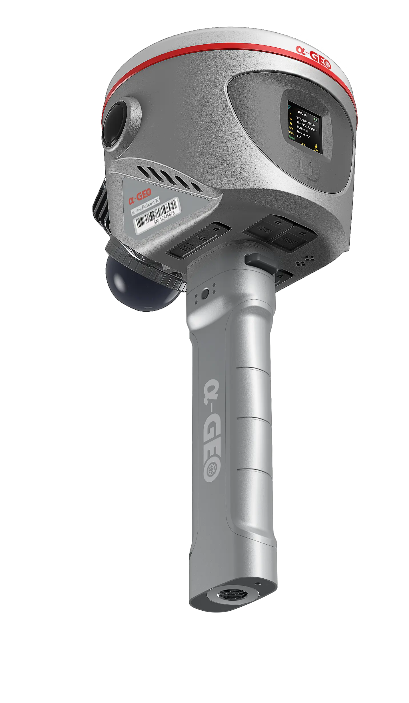
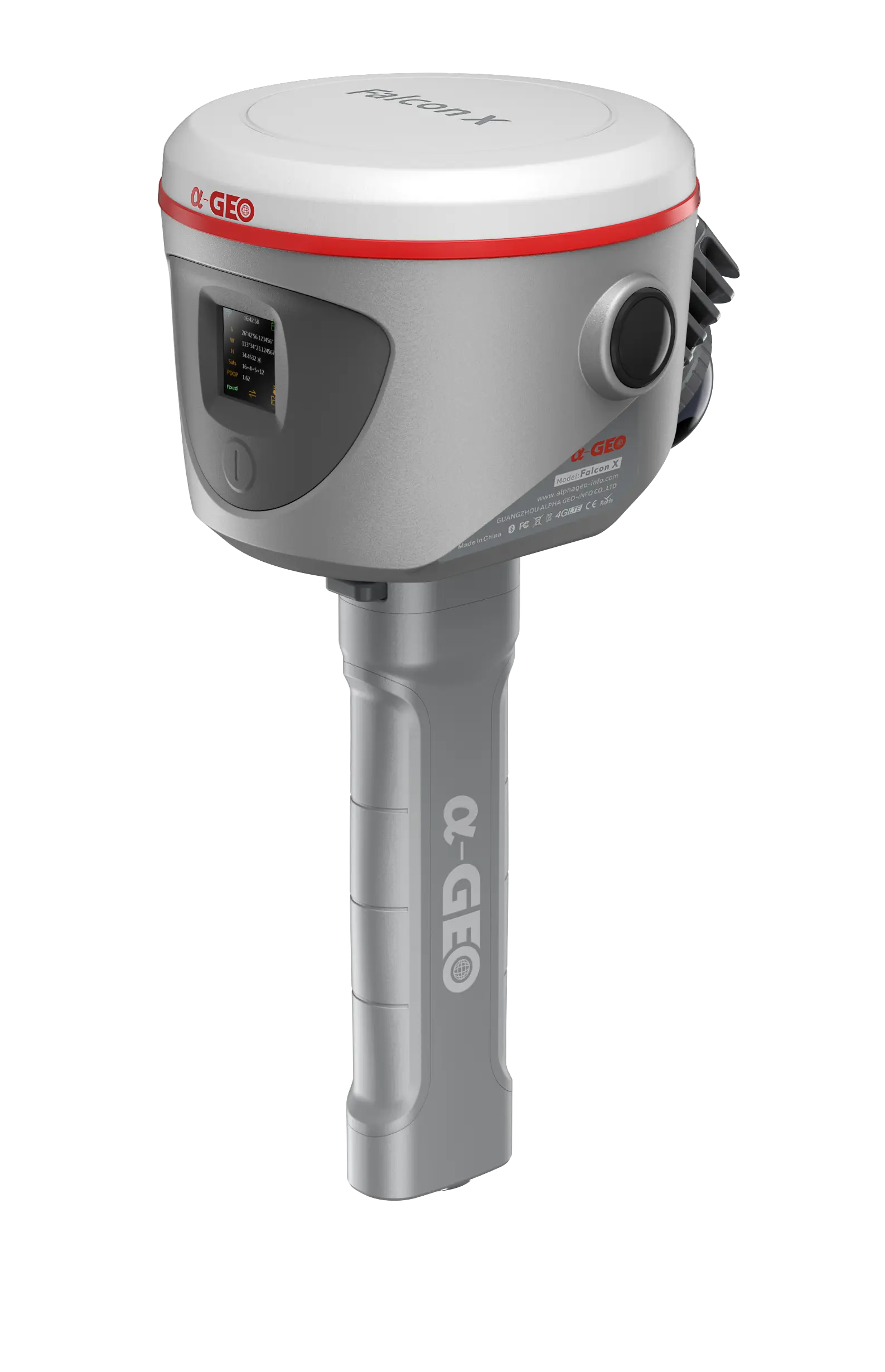
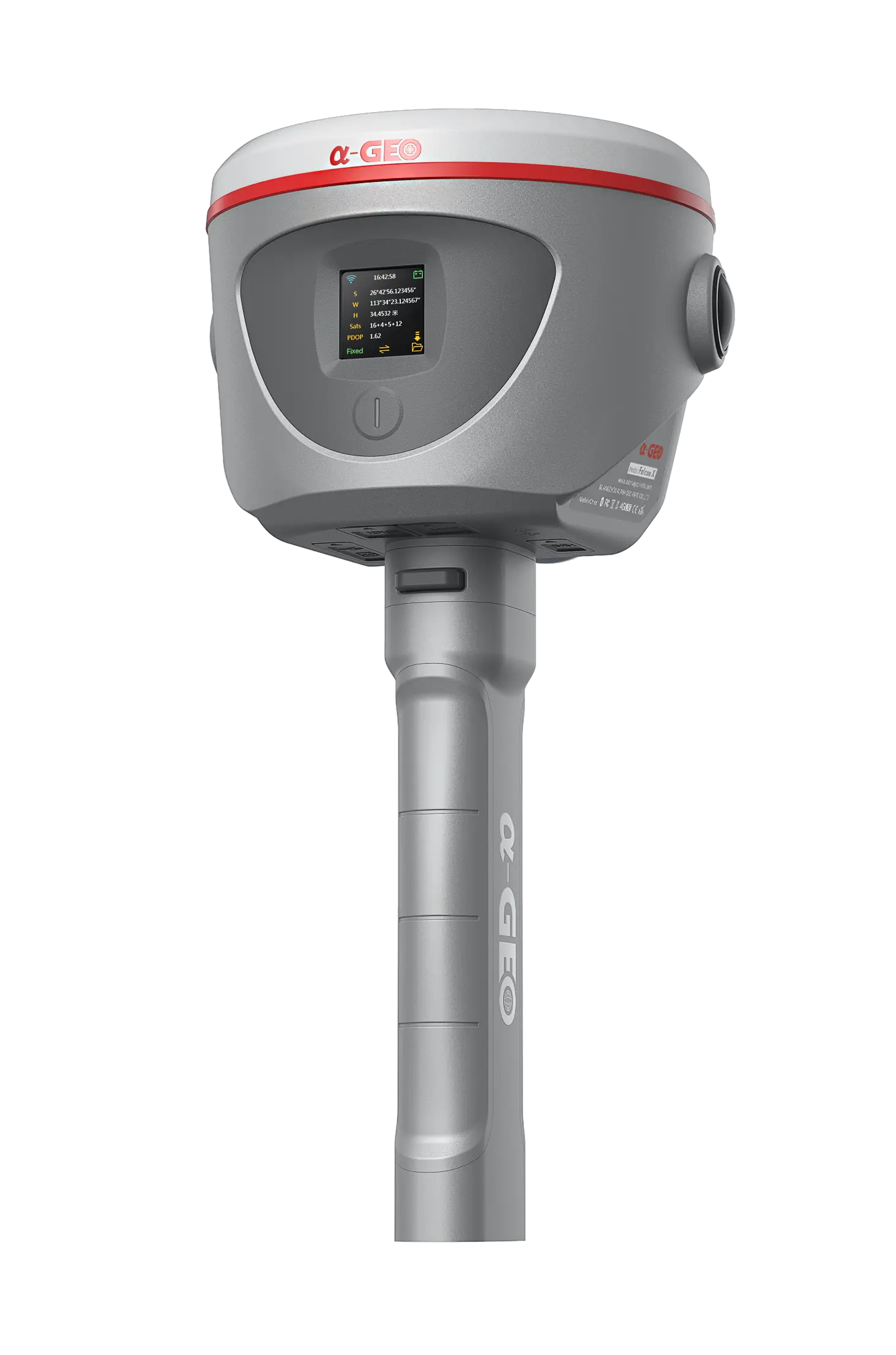


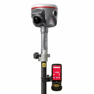

Alpha Geo Falcon X RTK SLAM Rover Set
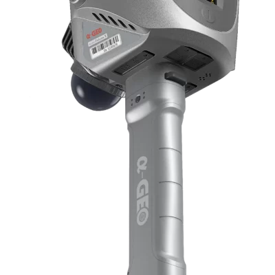
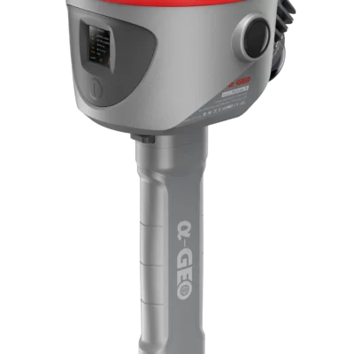
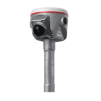
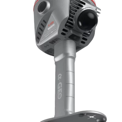
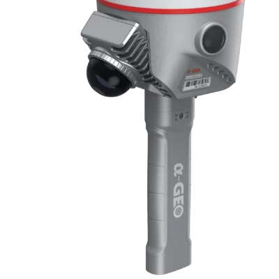
The Alpha Geo Falcon X Rover Set is a hybrid RTK GNSS and SLAM surveying system for professionals who need accurate measurement in both open-sky and GNSS-challenged environments. It combines a 1408-channel GNSS receiver, 4D IMU tilt compensation, integrated LiDAR SLAM scanning, panoramic cameras and AlphaGeo SurPro 6.0 field software in one complete rover workflow.
Use the Falcon X as a conventional RTK rover for point collection, control work and construction layout, or switch to SLAM scanning for tunnels, buildings, underground spaces, urban areas, forestry, volume work and other locations where satellite reception is limited.
Alpha Geo Falcon X Highlights
| Product type | Hybrid RTK GNSS rover and SLAM scanner set |
|---|---|
| GNSS channels | 1408 channels with GPS, GLONASS, Galileo, BeiDou, QZSS, IRNSS, SBAS and L-Band support |
| RTK accuracy | H: 8 mm + 1 ppm RMS / V: 15 mm + 1 ppm RMS |
| Tilt compensation | 4D IMU, 0° to 120°, <2.5 cm within 120° |
| SLAM scanning | 40-channel LiDAR, 200,000 points/s, up to 70 m range at 80% reflectivity |
| Camera system | Dual 48 MP colouring cameras and 5 MP AR camera |
| Software | AlphaGeo SurPro 6.0 app and Alpha Studio PC software |
| Protection rating | IP67 waterproof and dustproof housing |
Valued customers:


Find RTK Networks
Search NTRIP providers and connect to reliable RTK correction services.
Description
Alpha Geo Falcon X RTK SLAM Rover Set Product Review
Alpha Geo Falcon X Rover Set Product Description
The Alpha Geo Falcon X Rover Set is a complete hybrid surveying system for RTK GNSS measurement, SLAM scanning, point cloud collection and indoor-outdoor positioning. It is designed for surveyors, construction professionals, GIS teams, engineers, drone mapping teams and infrastructure specialists who need more than a standard GNSS rover.
In open-sky conditions, the Falcon X works as a high-precision RTK GNSS rover with multi-constellation tracking, fast RTK initialization, network RTK support, internal UHF, 4G, Wi-Fi, Bluetooth and IMU tilt compensation. When satellite visibility becomes poor, the integrated LiDAR SLAM system helps users continue mapping and collecting spatial data in places where a traditional GNSS receiver would normally struggle.
This makes the Falcon X especially useful for mixed fieldwork. A surveyor can measure outside with RTK, move into a tunnel, industrial building, forested area, underground utility corridor, parking garage or urban canyon, and continue collecting useful 3D data. The system connects GNSS, LiDAR, cameras, IMU sensors and field software into one practical workflow.
Hybrid RTK and SLAM Surveying Workflow
The Falcon X is built around two main working methods. In RTK mode, it functions as a professional GNSS rover mounted on a pole. This mode is suited for conventional survey work such as point collection, control measurement, construction checks, GIS positioning, site documentation and outdoor mapping where satellite visibility is available.
In SLAM mode, the Falcon X can be used for mobile point cloud mapping in GNSS-denied or GNSS-challenged locations. This is useful for tunnels, indoor spaces, underground areas, industrial plants, urban streets and locations where tall buildings, vegetation or overhead obstructions reduce GNSS performance.
For many field teams, the main advantage is continuity. Instead of stopping work when GNSS reception becomes unreliable, the Falcon X gives the user another measuring method within the same system. This makes it a strong option for projects that combine open outdoor areas with complex indoor or obstructed sections.
RTK GNSS Receiver Performance
The Falcon X uses a 1408-channel GNSS engine with support for GPS, GLONASS, BeiDou, Galileo, QZSS, IRNSS, SBAS and L-Band signals. This broad satellite tracking capability helps the rover maintain stable positioning in demanding field environments and gives users flexibility across different regions and correction service setups.
For RTK surveying, the receiver provides horizontal accuracy of 8 mm + 1 ppm RMS and vertical accuracy of 15 mm + 1 ppm RMS for baselines under 30 km. Network RTK accuracy is specified at 8 mm + 0.5 ppm RMS horizontal and 15 mm + 0.5 ppm RMS vertical. RTK initialization time is less than 5 seconds under suitable conditions.
4D IMU Tilt Compensation
The integrated 4D IMU allows tilt measurement from 0° to 120°. In practical fieldwork, this helps users measure points without perfectly levelling the pole every time. It is especially useful around corners, road edges, fences, building façades, trenches and other points that are awkward or unsafe to occupy directly.
The IMU initializes quickly and updates at 400 Hz. Tilt accuracy is specified as less than 2.5 cm within 120°, giving surveyors a faster way to collect points while keeping control over measurement quality.
Integrated LiDAR SLAM Scanning
The Falcon X includes a 40-channel LiDAR scanner for SLAM-based mapping. It measures up to 200,000 points per second and supports a scanning range from 0.1 m to 40 m at 10% reflectivity, or from 0.1 m to 70 m at 80% reflectivity. This allows users to capture dense spatial data while walking through a project area.
SLAM scanning is useful when the goal is not only to collect individual survey points, but also to document the surrounding environment as a point cloud. Common applications include tunnel surveying, building documentation, architectural elevation work, underground utility areas, forestry tracks, stockpile and volume projects, and complex urban mapping.
The Falcon X supports both real-time and post-processing workflows, with point cloud output in LAS format. Processing colour point cloud data and RTK fusion processing are also supported, helping teams combine visual, GNSS and LiDAR information into a practical deliverable.
Camera System and Visual Data
The Falcon X is equipped with three cameras: two 48 MP colouring cameras and one 5 MP AR camera. The panoramic camera setup supports a 190° × 190° field of view and is designed to help produce colour point cloud data during processing.
For field users and office teams, colourised point cloud data can make survey results easier to understand. This is valuable for documentation, inspection, design reference and communication with engineers, contractors, project owners and CAD or BIM teams.
AlphaGeo SurPro 6.0 Field Software
The Falcon X works with the AlphaGeo SurPro 6.0 Android application. The app connects to the receiver and is used to manage surveying, SLAM scanning and device configuration functions.
Through SurPro 6.0, users can configure GNSS and SLAM parameters, perform RTK point collection, control SLAM scanning and point cloud acquisition, and monitor device status and positioning quality. This is important for a rover set because the receiver, software and data collector work together as one field system rather than separate tools.
The Falcon X also supports standalone SLAM scanning without the Android controller. This is useful for quick or basic scanning tasks directly from the device. For full visualization, project naming, point collection and point cloud management, controller mode with SurPro 6.0 is used.
Connectivity for Professional Fieldwork
The Falcon X is designed for modern RTK and scanning workflows. It includes internal 1.5 W UHF radio, 4G cellular connectivity, Wi-Fi, Bluetooth 5.2, a Nano SIM slot, Type-C interface, LEMO5 interface, SMA UHF antenna interface and microSD storage. Supported differential data formats include RTCM2x and RTCM3x.
For surveyors, this means the rover can be used with network RTK services, internal radio workflows and direct device communication depending on the project setup. This flexibility is useful for construction sites, infrastructure work, rural surveying, urban mapping and international projects where correction methods may vary.
Built for Demanding Survey Environments
The Falcon X has a rugged magnesium alloy body and an IP67 waterproof and dustproof rating. It is specified for operation from -20°C to +50°C and storage from -40°C to +80°C, making it suitable for professional fieldwork in changing weather and site conditions.
Battery life is specified at approximately 180 minutes in SLAM mode and typically up to 8 hours in RTK mode using phone internet. For field crews, this means the same system can support both high-power scanning tasks and longer conventional RTK survey sessions.
Typical Applications
- Land surveying and topographic measurement
- Construction layout, checks and site documentation
- Tunnel, underground and utility corridor surveying
- Urban mapping and infrastructure documentation
- Forestry, volume calculation and stockpile measurement
- Indoor and outdoor point cloud collection
- Engineering, BIM and architectural survey support
- GIS data collection in difficult GNSS environments
Who Is the Alpha Geo Falcon X Rover Set For?
The Alpha Geo Falcon X Rover Set is a strong fit for professionals who regularly move between open-sky GNSS work and obstructed or indoor areas. Surveyors can use it for RTK point work and scanning. Construction workers can use it for site measurement and as-built documentation. GIS teams can collect accurate position data in complex locations. Drone pilots and mapping teams can add ground-based point clouds to aerial survey data. Engineers and infrastructure teams can document hard-to-measure spaces without relying on one measuring method only.
It is especially useful for buyers comparing a standard RTK rover with a more flexible GNSS and LiDAR system. If most work is simple open-field point collection, a conventional RTK rover may be enough. If projects often include bridges, tunnels, buildings, vegetation, urban canyons or underground spaces, the Falcon X gives the field team more options in one set.
Buying from Global GPS Systems
Global GPS Systems supplies the Alpha Geo Falcon X Rover Set with worldwide shipping from the Netherlands, insured transport, import and export support, and product guidance from GNSS specialists. For buyers comparing RTK GNSS, LiDAR and SLAM equipment, this support can help match the system to the right field workflow, correction service and software setup.
The Falcon X is a practical choice for teams that want one system for accurate RTK surveying, mobile SLAM scanning and indoor-outdoor mapping. It brings together GNSS positioning, LiDAR data capture, IMU tilt compensation, camera support and field software in a workflow built for modern surveying and mapping projects.
Datasheets & Manuals
Datasheets and manuals
Datasheets & manuals
Specifications
Alpha Geo Falcon X Rover Set Specifications
Product Overview
| Product Name | Alpha Geo Falcon X Rover Set |
|---|---|
| Product Type | Hybrid RTK GNSS rover and SLAM LiDAR scanner set |
| Primary Use | RTK GNSS surveying, SLAM scanning, point cloud collection, indoor/outdoor mapping and GNSS-challenged positioning |
| Operating Modes | RTK GNSS rover mode and handheld SLAM scanning mode |
| Typical Users | Surveyors, construction professionals, GIS teams, engineers, infrastructure specialists, drone mapping teams and 3D scanning professionals |
| Typical Applications | Land surveying, topographic measurement, construction layout, tunnel surveying, underground spaces, industrial sites, forestry, urban mapping, stockpile measurement, volume work, architectural documentation and infrastructure inspection |
GNSS Performance
| GNSS Channels | 1408 channels |
|---|---|
| GPS Signal Tracking | L1 C/A, L2C, L2P, L5 |
| GLONASS Signal Tracking | L1, L2, L3* |
| BeiDou / BDS Signal Tracking | B1, B1C, B2, B2a, B2b, B3 |
| Galileo Signal Tracking | E1, E5a, E5b, E6* |
| QZSS Signal Tracking | L1, L2, L5, L6* |
| IRNSS Signal Tracking | L5* |
| SBAS Signal Tracking | L1, L5 |
| L-Band | B2b (BDSPPP), E6B (HAS) |
| Cold Start | <60 s |
| Hot Start | <15 s |
| Positioning Output Rate | 1 Hz – 50 Hz |
| Signal Reacquisition | <1 s |
| RTK Initialization Time | <5 s |
| Initialization Reliability | >99.99% |
| Time Accuracy | 20 ns |
GNSS Accuracy
| Positioning Mode | Horizontal Accuracy | Vertical Accuracy |
|---|---|---|
| Code Differential GNSS | 0.25 m + 1 ppm RMS | 0.50 m + 1 ppm RMS |
| Static GNSS Surveying | 2.5 mm + 0.5 ppm RMS | 5 mm + 0.5 ppm RMS |
| RTK Surveying, Baseline <30 km | 8 mm + 1 ppm RMS | 15 mm + 1 ppm RMS |
| Network RTK | 8 mm + 0.5 ppm RMS | 15 mm + 0.5 ppm RMS |
| SBAS Differential Positioning | Typically <5 m 3DRMS |
|---|
Tilt Performance
| IMU | Supported, 4D IMU |
|---|---|
| IMU Initialization | Approximately 3 seconds |
| IMU Update Rate | 400 Hz |
| Tilt Compensation Range | 0° – 120° |
| Tilt Accuracy | <2.5 cm within 120° |
SLAM LiDAR Performance
| Laser Channels | 40 |
|---|---|
| Scanning Range at 10% Reflectivity | 0.1 m – 40 m |
| Scanning Range at 80% Reflectivity | 0.1 m – 70 m |
| Measurement Rate | 200,000 points/s |
| Scanning Speed | 10 Hz |
| Laser Field of View | 360° × -7° to 52° |
| Laser Safety Class | Class 1 |
| Laser Wavelength | 905 nm |
| Processing Mode | Real-time and post-processing |
| Point Cloud Format | .las |
| Real-time Color Point Cloud | Not supported |
| Processing Color Point Cloud | Supported |
| RTK Fusion Processing | Supported |
SLAM Accuracy
| Absolute Accuracy, Indoor | ≤5 cm |
|---|---|
| Absolute Accuracy, RTK | ≤6 cm |
| Point Cloud Thickness | ≤3 cm |
| Relative Accuracy | <1.2 cm |
| Horizontal Angle Resolution | ≤0.05° |
Camera System
| Number of Cameras | 3 |
|---|---|
| Coloring Cameras | 2 × 48 MP |
| Camera Field of View | 190° × 190° |
| AR Camera | 5 MP |
| Camera Function | Color point cloud processing and AR-supported field workflow |
Communications and Interfaces
| I/O Interface | 1 × LEMO5 |
|---|---|
| Memory Card Slot | 1 × TF card slot |
| SIM Card Slot | 1 × NanoSIM card slot |
| USB Interface | 1 × Type-C interface |
| UHF Antenna Interface | 1 × SMA UHF antenna interface |
| Display | 1.3-inch color LED display, 240 × 240 resolution |
| Internal UHF | Internal 1.5 W UHF |
| UHF Frequency Band | 410 MHz – 470 MHz |
| Radio Protocols | Trimtalk450S, Alphatalk15, South, Satel, PCC-EOT |
| Cellular Network | Multi-band 4G modem supporting TDD-LTE, FDD-LTE, WCDMA and CDMA2000 |
| Wi-Fi | 802.11a/b/g/n/ac |
| Bluetooth | Bluetooth 5.2 |
| Differential Data Format | RTCM2x, RTCM3x |
| Correction Data Workflows | Internal UHF, external/phone internet, device internet and NTRIP-style correction workflows via field software |
Software and Workflow
| Field Software | AlphaGeo SurPro 6.0 Android application |
|---|---|
| PC Software | Alpha Studio PC software |
| Device Connection | Falcon X connects to SurPro 6.0 via Bluetooth |
| Supported Field Functions | GNSS configuration, SLAM configuration, RTK surveying, point collection, SLAM scanning, point cloud acquisition, device status monitoring and positioning quality monitoring |
| SurPro Survey Functions | Point survey, detail survey, control point survey, point stakeout, CAD, line stakeout, DSM stakeout, road stakeout, polyline survey, polygon survey and GIS function customization |
| Standalone SLAM Operation | Supported for scanning directly from the device; controller mode is used for full visualization, project naming, point collection and point cloud management |
| Post-Processing Support | Color point cloud processing and RTK fusion processing supported |
Data Storage and Power
| External Memory | 256 GB, extendable up to 512 GB with microSD card |
|---|---|
| Battery Type | 14.4 V, 47.52 Wh Li-ion battery |
| Battery Life, SLAM Mode | 180 minutes |
| Battery Life, RTK Mode | Typically 8 hours using phone internet |
| Battery Charging Time | 2 hours |
| Power Consumption, SLAM | <25 W |
| Power Consumption, RTK | 2.5 W |
Physical Specifications
| Body Material | Magnesium alloy |
|---|---|
| Dimensions | 138 mm diameter × 301 mm height, with battery and plate |
| Weight | 1.8 kg |
| Pole Mounting Thread | 5/8"-11 GNSS pole mounting thread |
| Operating Temperature | -20°C to +50°C |
| Storage Temperature | -40°C to +80°C |
| Waterproof / Dustproof Rating | IP67 |
Hardware Components
| GNSS Receiver Module | Integrated |
|---|---|
| LiDAR Sensor | Integrated |
| RGB Cameras | Left RGB camera and right RGB camera |
| Auxiliary Camera | AR camera |
| Battery Pack | Clip-on rechargeable battery pack |
| Control Point Marker Plate | Included hardware component |
| Display | 1.3-inch LED information display |
| Battery Indicator | 4-LED battery level indicator |
| Speaker Grilles | Integrated |
| Ventilation Grilles | Integrated; should not be blocked during use |
Standard Package Contents
| Item | Quantity | Notes |
|---|---|---|
| Falcon X Protective Carrying Case | 1 | Standard unit package |
| Falcon X Unit | 1 | Main GNSS SLAM RTK device |
| Control Point Marker Plate | 1 | For SLAM/control point workflow |
| Falcon X USB-A to USB-C Cable | 1 | USB 3.0 fast data cable |
| Battery Charger | 1 | For clip-on battery pack |
| Clip-on Rechargeable Battery Pack | 2 | Rechargeable Falcon X batteries |
| UHF Radio Antenna | 1 | For internal UHF radio use |
| SD Card Reader | 1 | For data transfer |
Advanced Package Additional Contents
| Item | Quantity | Notes |
|---|---|---|
| Android Device Pole Holder | 1 | Included with advanced unit package |
| Android Device USB-A to USB-C Cable | 1 | Data and charging cable |
| Android Device USB Power Adapter | 1 | 5 V adapter for A-TAB |
| AlphaGeo A-TAB Android Tablet | 1 | Controller listed in the advanced unit package |
Performance Notes
| GNSS Accuracy Conditions | Accuracy and reliability may be affected by signal obstruction, tilt angle, observation time, multipath and atmospheric conditions. |
|---|---|
| SLAM Accuracy Conditions | SLAM accuracy values are based on AlphaGeo test scenarios and may vary in certain field situations. |
| Battery Life Conditions | Battery endurance is tested in an AlphaGeo experimental environment and actual runtime depends on usage environment and operating conditions. |
Specifications and package contents may vary by configuration, region or manufacturer update. Always check the current configuration before ordering.
FAQ
Alpha Geo Falcon X Rover Set FAQ
Product Overview and Applications
What is the Alpha Geo Falcon X Rover Set?
The Alpha Geo Falcon X Rover Set is a hybrid RTK GNSS rover and SLAM scanning system. It combines high-precision GNSS positioning, LiDAR point cloud capture, IMU tilt compensation, panoramic cameras, and field software into one surveying workflow.
Who is the Falcon X Rover Set designed for?
The Falcon X is designed for land surveyors, construction professionals, GIS teams, engineers, infrastructure specialists, drone mapping teams, and 3D scanning users who need accurate positioning and point cloud data in both open-sky and GNSS-challenged environments.
Is the Falcon X a GNSS rover or a SLAM scanner?
It is both. The Falcon X can be used as a conventional RTK GNSS rover for point collection and surveying, and it can also be used as a LiDAR SLAM scanner for mapping areas where GNSS reception is limited or unavailable.
Which applications is the Falcon X suitable for?
The Falcon X is suitable for land surveying, topographic measurement, construction layout, tunnel surveying, underground spaces, urban mapping, forestry, stockpile documentation, volume calculation, architectural elevation surveys, utility corridors, industrial sites, and infrastructure documentation.
Why choose a hybrid RTK GNSS and SLAM rover?
A hybrid rover helps field teams continue working across different environments. RTK GNSS can be used outdoors where satellite visibility is available, while SLAM scanning can be used indoors, underground, in tunnels, near buildings, in forests, or in other places where GNSS signals are obstructed.
Can the Falcon X be used for indoor and outdoor projects?
Yes. The Falcon X is built for mixed indoor and outdoor workflows. Users can collect precise RTK GNSS points outside and use SLAM scanning to capture point clouds in indoor or obstructed areas.
GNSS, RTK and Tilt Measurement
Can the Falcon X be used as a normal RTK GNSS rover?
Yes. In RTK mode, the Falcon X works as a professional GNSS rover for point collection, control work, site measurement, GIS positioning, mapping, and other standard RTK surveying tasks.
What GNSS constellations does the Falcon X support?
The Falcon X supports multi-constellation GNSS tracking, including GPS, GLONASS, BeiDou, Galileo, QZSS, IRNSS, SBAS, and L-Band signals.
How many GNSS channels does the Falcon X have?
The Falcon X has a 1408-channel GNSS engine, allowing it to track many satellite signals for stable positioning in professional surveying applications.
What RTK accuracy does the Falcon X provide?
For RTK surveying with a baseline under 30 km, the Falcon X is specified at 8 mm + 1 ppm RMS horizontal accuracy and 15 mm + 1 ppm RMS vertical accuracy. Network RTK accuracy is specified at 8 mm + 0.5 ppm RMS horizontal and 15 mm + 0.5 ppm RMS vertical.
Does the Falcon X support IMU tilt compensation?
Yes. The Falcon X includes 4D IMU tilt compensation from 0° to 120°. This allows users to measure points more efficiently without perfectly leveling the pole for every observation.
How accurate is the Falcon X tilt compensation?
The Falcon X tilt accuracy is specified as less than 2.5 cm within 120°. IMU initialization takes approximately 3 seconds, making it useful for fast field measurement around corners, obstacles, fences, trenches, walls, and other difficult-to-reach points.
What correction methods does the Falcon X support?
The Falcon X supports multiple correction workflows, including device internet, internal radio, phone internet, and PPP. It also supports common RTCM2x and RTCM3x differential data formats for RTK and NTRIP workflows.
SLAM Scanning and Point Clouds
What is SLAM scanning on the Falcon X?
SLAM scanning allows the Falcon X to create 3D point cloud data while the user walks through a project area. It is especially useful in places where GNSS signals are weak, blocked, or unavailable.
Where is the Falcon X SLAM function most useful?
The SLAM function is useful in tunnels, buildings, underground spaces, parking garages, urban canyons, forests, industrial sites, utility corridors, stockpile areas, and other environments where a standard GNSS-only rover may struggle.
How many points per second can the Falcon X scan?
The Falcon X integrated LiDAR scanner has a measurement rate of up to 200,000 points per second, allowing it to capture dense 3D spatial data during mobile scanning.
What is the scanning range of the Falcon X?
The Falcon X scanning range is specified from 0.1 m to 40 m at 10% reflectivity and from 0.1 m to 70 m at 80% reflectivity.
What SLAM accuracy does the Falcon X provide?
The Falcon X SLAM accuracy is specified as indoor absolute accuracy of up to 5 cm, RTK absolute accuracy of up to 6 cm, point cloud thickness of up to 3 cm, and relative accuracy of less than 1.2 cm.
What point cloud format does the Falcon X export?
The Falcon X supports point cloud output in .las format, which is commonly used for LiDAR and point cloud workflows.
Does the Falcon X support color point clouds?
Yes. The Falcon X supports processed color point clouds using its camera system. Real-time color point cloud generation is not supported.
Software, Connectivity and Field Use
What software is used with the Falcon X Rover Set?
The Falcon X works with the AlphaGeo SurPro 6.0 Android app for field control, GNSS configuration, RTK surveying, SLAM scanning, point collection, and device monitoring. Alpha Studio PC software is also part of the Falcon X processing workflow.
Can the Falcon X scan without an Android controller?
Yes. The Falcon X supports standalone SLAM scanning directly from the device. Controller mode with SurPro 6.0 provides additional functions such as visualization, project naming, point collection, and point cloud management.
What cameras are built into the Falcon X?
The Falcon X has three cameras: two 48 MP coloring cameras and one 5 MP AR camera. The camera system helps support visual documentation, colorized point cloud processing, and field interpretation.
What connectivity options does the Falcon X offer?
The Falcon X includes internal UHF, 4G cellular, WiFi, Bluetooth 5.2, Type-C, NanoSIM, TF card slot, SMA UHF antenna interface, and LEMO5 connectivity for flexible field communication and data handling.
How long does the Falcon X battery last?
The Falcon X battery life is specified as approximately 180 minutes in SLAM mode and typically up to 8 hours in RTK mode when using phone internet. Actual battery life depends on settings, environment, communication method, and field workflow.
Is the Falcon X suitable for rugged field conditions?
Yes. The Falcon X has a magnesium alloy body, IP67 waterproof and dustproof protection, and an operating temperature range from -20°C to +50°C, making it suitable for professional outdoor and site-based surveying work.
Additional information
| GNSS feature | GNSS with Camera, GNSS with IMU, GNSS with Lidar |
|---|
Reviews (0)
Only logged in customers who have purchased this product may leave a review.

Reviews
There are no reviews yet