
 GPS & GNSS
 Lidar scanning
 Total Station
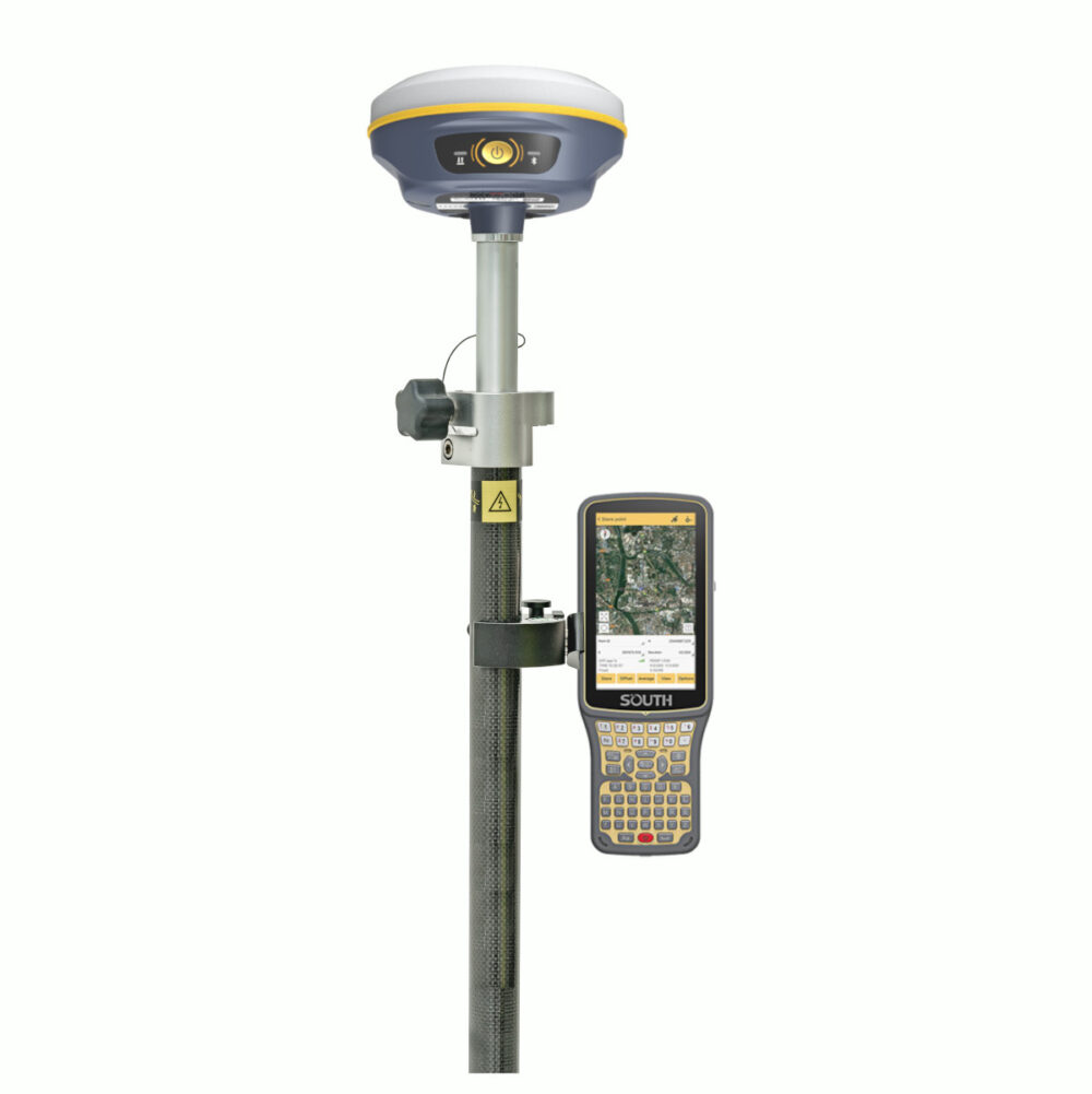
SOUTH Insight V2 Visual RTK GNSS Rover Set with IMU
Currently unavailable
Get the best price for your setup
Contact us for expected delivery time.
This product is end of life


Valued customers:










Find RTK Networks
Search NTRIP providers and connect to reliable RTK correction services.
Description
Visual RTK GNSS Surveying for Faster Field Layout
The SOUTH Insight V2 Rover Set combines an RTK GNSS receiver, camera, IMU tilt sensor and complete field controller setup in one practical surveying package. It is designed for surveyors, construction teams, site engineers, GIS professionals and contractors who need centimetre-level positioning for measuring existing features or setting out new work.
The rover can be used for boundary and cadastral surveys, topographic mapping, utility and asset collection, road and infrastructure projects, earthworks, building foundations and general construction layout. Because the set includes the SOUTH H6 controller, SurvStar field software, a telescopic pole and controller bracket, users receive the main equipment needed to begin a network RTK or radio-based rover workflow.
AR Stakeout with Live Visual Guidance
Traditional stakeout screens normally guide the operator using arrows, numerical offsets and a plan view. The Insight V2 adds a downward-facing camera and augmented reality guidance. When approaching a design point, SurvStar can display a virtual guideline, direction and distance over the live camera image.
This visual approach makes it easier to understand which way to move, particularly on busy construction sites or when several points are positioned close together. It can reduce repeated trial measurements and helps less experienced operators follow a stakeout route more confidently. AR guidance can support point, line and CAD-based stakeout workflows within compatible SurvStar functions.
Measure Without Constantly Levelling the Pole
The integrated IMU compensates for pole tilt up to 60°. Instead of stopping to centre the bubble for every observation, the operator can measure while the pole is tilted and the software calculates the coordinate at the pole tip.
This is useful when collecting points beside buildings, fences, parked machinery, vegetation or excavations where a vertical pole position is difficult. It also improves working speed on slopes and uneven terrain. The IMU is designed to initialise quickly through normal movement and does not require traditional magnetic calibration, reducing setup work when moving between survey areas.
Multi-Constellation GNSS Performance
The 1,598-channel receiver tracks signals from GPS, GLONASS, Galileo, BeiDou, QZSS, SBAS and IRNSS. Multi-frequency and multi-constellation tracking gives the rover access to more usable satellite observations and supports reliable RTK positioning in everyday field conditions.
Specified real-time kinematic accuracy is 8 mm + 1 ppm horizontally and 15 mm + 1 ppm vertically under suitable conditions. Actual results depend on the correction source, satellite visibility, baseline length, multipath, atmospheric conditions and correct field procedures. For professional work, control checks and project-specific accuracy requirements should always remain part of the workflow.
Radio and Network RTK Workflows
The Insight V2 has an integrated 2 W UHF transceiver operating from 410 to 470 MHz. It supports Farlink and several commonly used radio protocols, allowing the rover to receive corrections from a compatible local base station. SOUTH specifies a typical Farlink communication range of up to 8 km in suitable open conditions, although terrain, buildings, interference and local radio regulations affect the practical range.
The receiver does not contain an integrated cellular modem. For NTRIP network RTK work, the correction connection can be managed through the internet-enabled field controller or a compatible Wi-Fi data link. This arrangement suits users who already work with an RTK correction network and do not need a separate SIM card inside the GNSS receiver.
Designed for Full Working Days
A built-in 6,800 mAh battery provides approximately 12 hours of specified rover operation. USB Type-C charging makes it easier to recharge the receiver using commonly available charging equipment, and external power can support longer projects where access to mains power is limited.
The magnesium-aluminium alloy housing is rated to IP68 for protection against dust and water. The receiver is also designed to withstand a natural 2 metre pole drop onto concrete. At approximately 800 grams, it remains light enough for repeated point collection and extended stakeout work.
SurvStar Field Data Collection
SurvStar provides the field interface for configuring the receiver, collecting points and performing stakeout. It supports common survey workflows including point and line measurement, CAD-based work, static data collection and PPK recording. Field data can be organised into layers and exported in formats suitable for further CAD, GIS or survey processing.
The SOUTH H6 controller gives the operator a dedicated field device for managing jobs, coordinate systems, correction connections and measured data. Together with the supplied pole and bracket, it creates a portable rover setup that can be carried between sites without assembling components from several separate packages.
Who Is the SOUTH Insight V2 Rover Set For?
For land surveyors, the system supports topographic surveys, boundaries, control checks and routine detail collection. Construction teams can use it for foundations, utilities, roads, kerbs, earthworks and design-point layout. GIS crews can collect accurate locations for assets and infrastructure, while engineering and inspection teams can record positions for as-built documentation and site progress.
The visual guidance and tilt compensation are also useful for contractors moving from basic positioning equipment to professional RTK GNSS. These functions make common field tasks easier to understand without removing the controls and data formats required by experienced survey professionals.
Configuration and Support from Global GPS Systems
Global GPS Systems can help confirm the most suitable correction method, radio compatibility, controller setup and software configuration for the intended project. This is particularly important when connecting the rover to an existing base station, selecting an NTRIP service or working with local coordinate systems.
The SOUTH Insight V2 Rover Set is a practical choice for buyers who need a lightweight visual RTK rover with centimetre-level positioning, camera-assisted stakeout, IMU tilt measurement and a complete field controller package.
Datasheets & Manuals
Datasheets and manuals
Reviews (0)
Only logged in customers who have purchased this product may leave a review.
 GPS & GNSS
 Total Stations
 Data collectors
 Software
 Correction services
 Machine control
 External radio
 Lasers & levellers
 Marine
 Accessories
Reviews
There are no reviews yet