


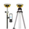
South Insight V4 Visual RTK GNSS Receiver with IMU
This product is Available
Contact our experts for the best possible price and configuration.
The South Insight V4 is a compact RTK GNSS receiver built for surveyors, construction teams, engineers, GIS professionals and mapping crews who need reliable centimetre-level positioning in a small and easy-to-carry receiver. With 1698 channels, dual-camera AR stakeout, 5th generation IMU tilt compensation and optional visual positioning, it helps field users measure and stake out faster in urban areas, open sites and more difficult GNSS environments.
South Insight V4 Highlights
| GNSS Channels | 1698 channels with GPS, GLONASS, Galileo, BeiDou, QZSS and SBAS support |
|---|---|
| IMU Tilt Compensation | 5th generation calibration-free IMU up to 60° |
| Camera Functions | Dual-camera AR stakeout with 8 MP visual positioning camera and 2 MP AR stakeout camera |
| Visual Measurement | Optional visual positioning and 3D modelling workflow |
| Field Design | 540 g pocket-size RTK receiver with IP68 protection and up to 20 hours rover battery life |


Valued customers:


Find RTK Networks
Search NTRIP providers and connect to reliable RTK correction services.
Description
Compact visual RTK GNSS for modern fieldwork
The South Insight V4 is a pocket-size RTK GNSS receiver designed for professionals who want a lightweight rover without giving up advanced surveying features. It is well suited for land surveyors, construction layout teams, civil engineers, GIS users, utility mapping crews and drone surveyors who need accurate GNSS data in daily field conditions.
At only 540 g, the receiver is easy to carry between jobs, climb with, or use for longer days on site. This makes it practical for construction staking, topographic surveys, road and infrastructure projects, boundary work, utility surveys, public works mapping and field checks after drone flights.
Reliable satellite tracking with 1698 channels
The South Insight V4 uses the SOUTH S805 GNSS platform with 1698 channels. In practical fieldwork, this means the receiver can track many satellite signals across multiple constellations, helping the user maintain positioning performance when working near buildings, trees or other partial obstructions.
For surveyors and site engineers, better satellite availability can reduce waiting time for a fixed RTK solution. This is especially useful when moving between open areas, streets, building edges, tree lines and mixed construction environments during the same job.
Dual-camera AR stakeout for easier layout work
The Insight V4 includes dual-camera AR stakeout, allowing users to stake out points, lines and curves with visual guidance on the controller screen. Instead of only following numbers and arrows, the field user can see a more intuitive direction to the target.
This is useful for construction workers and surveyors who need to find design points quickly on busy sites. AR stakeout can make the workflow easier to understand for less experienced GNSS users while still giving professional crews a faster way to move from point to point.
5th generation IMU tilt compensation
The built-in 5th generation IMU helps users measure with the pole tilted up to 60°. In real site conditions, this is useful when a point is close to a wall, fence, trench, vehicle, pile of material or another obstacle that makes it difficult to keep the pole perfectly vertical.
Because the IMU is calibration-free, the operator can work more naturally with fewer interruptions. This helps keep production moving during stakeout, mapping and general RTK measurement tasks.
Optional visual positioning for hard-to-reach points
With optional visual positioning, the South Insight V4 can be used for non-contact measurement workflows. This allows users to collect coordinates from photos or video instead of physically occupying every point with the pole.
For field teams, this can be helpful around unsafe or inconvenient locations such as road edges, water, excavations, blocked areas, dense objects, rooftops or places with limited access. It can also help fill in points that are difficult to measure with traditional RTK methods.
Optional 3D modelling support
The Insight V4 can support optional 3D modelling workflows using image data. This is useful for surveyors, GIS specialists and drone pilots who need to supplement UAV models or collect extra detail from the ground.
For drone mapping users, ground image data can help fill gaps where aerial data is incomplete or where the drone view is blocked. For engineering and GIS work, this can support documentation of sites, areas, volumes and visible features.
Built for real field conditions
The South Insight V4 is designed for outdoor surveying work. Its IP68 protection helps protect the receiver against dust and water, while the rugged housing is made for daily use on construction sites, roads, fields and infrastructure projects.
The receiver has an internal 5000 mAh rechargeable lithium-ion battery with up to 20 hours of rover operation. For long workdays, this helps reduce battery changes and keeps the rover ready for extended field sessions.
Communication and data workflow
The Insight V4 supports Bluetooth, Wi-Fi, NFC, Type-C connection, OTG storage and Ethernet through the Type-C interface. It also includes UHF receiving in the 410–470 MHz range, making it suitable for rover workflows where corrections are received from a compatible base or correction source.
For data handling, the receiver includes 16 GB internal storage, supports common correction and output formats, and works with SOUTH field and office software workflows such as SurvStar and SOUTH Geo Office. Field teams can collect RTK, static and PPK data, manage files and move data into office processing when needed.
Who is the South Insight V4 for?
The South Insight V4 is a strong choice for professionals who need a small, advanced RTK rover with visual guidance and tilt measurement. It is especially useful for construction layout teams, surveyors working in mixed urban conditions, GIS users collecting accurate field data, utility mapping crews, civil engineers and drone pilots who need ground control or additional field measurements.
It is also a practical option for companies that want modern GNSS features in a compact receiver. The combination of AR stakeout, IMU tilt, multi-constellation GNSS tracking and optional visual positioning gives field users more flexibility than a basic RTK receiver.
Buying from Global GPS Systems
Global GPS Systems supplies the South Insight V4 with worldwide delivery from the Netherlands and support from GNSS product specialists. This is useful for buyers who want help choosing the right receiver, controller, software and correction workflow for their surveying, construction, GIS or drone mapping work.
For teams comparing RTK GNSS equipment, the South Insight V4 offers a compact form factor with high-end field features, making it a good fit for professionals who want faster stakeout, easier point collection and more flexible measurement options on site.
Datasheets & Manuals
Datasheets and manuals
Datasheet
Specifications
South Insight V4 Specifications
Product Overview
| Product Name | South Insight V4 |
|---|---|
| Product Type | Visual Positioning RTK GNSS Receiver |
| Manufacturer | SOUTH Surveying & Mapping Instrument Co., Ltd. |
| Main Applications | Land surveying, construction layout, RTK/PPK surveying, visual positioning, AR stakeout, cadastral survey, 3D modelling support and field data collection |
| GNSS Engine | SOUTH S805 |
| GNSS Channels | 1698 channels |
| Key Technologies | Dual-engine GNSS algorithm, Farlink radio, 5th generation IMU, dual-camera AR stakeout, visual positioning and video/photo-based 3D modelling support |
GNSS Signal Tracking
| GPS | L1C, L1C/A, L2C, L2P(Y), L5 |
|---|---|
| GLONASS | G1, G2, G3 |
| BeiDou / BDS | B1I, B2I, B3I, B1C, B2a, B2b |
| Galileo | E1, E5a, E5b, E6, AltBOC* |
| SBAS | L1* |
| IRNSS | L5* |
| QZSS | L1, L2C, L5* |
| MSS L-Band | Reserved for future upgrade* |
Positioning Performance
| Position Output Rate | 1 Hz to 20 Hz |
|---|---|
| Initialization Time | < 10 s |
| Initialization Reliability | > 99.99% |
| RTK Initialization Time | 2 s to 8 s |
| IMU Tilt Angle | 0° to 60° |
| SBAS Positioning | Typically < 5 m 3DRMS |
Positioning Accuracy
| Mode | Horizontal Accuracy | Vertical Accuracy |
|---|---|---|
| Code Differential Positioning | 0.25 m + 1 ppm RMS | 0.50 m + 1 ppm RMS |
| GNSS Static | 2.5 mm + 0.5 ppm RMS | 3.5 mm + 0.5 ppm RMS |
| Static, Long Observation | 2.5 mm + 0.1 ppm RMS | 3 mm + 0.4 ppm RMS |
| Rapid Static | 2.5 mm + 0.5 ppm RMS | 5 mm + 0.5 ppm RMS |
| PPK | 3 mm + 1 ppm RMS | 5 mm + 1 ppm RMS |
| RTK via UHF | 8 mm + 1 ppm RMS | 15 mm + 1 ppm RMS |
| RTK via NTRIP | 8 mm + 0.5 ppm RMS | 15 mm + 0.5 ppm RMS |
IMU, Camera and Sensors
| IMU | Built-in calibration-free IMU module |
|---|---|
| IMU Tilt Compensation | Up to 60° |
| IMU Generation | 5th generation IMU |
| Visual Positioning Camera | 8 MP camera; usable for visual positioning and AR stakeout |
| AR Stakeout Camera | 2 MP camera |
| Dual-Camera AR Stakeout | Supports front and bottom camera use for point, line and curve stakeout |
| Visual Positioning | Supports non-contact measurement by photo or video; coordinates can be obtained from captured imagery |
| 3D Modelling Support | Supports image/video data collection for 3D modelling workflows with SOUTH software and compatible third-party modelling software |
| Electronic Bubble | Controller software can display electronic bubble and check pole levelling status in real time |
| Thermometer | Built-in thermometer sensor with intelligent temperature control for receiver temperature monitoring and adjustment |
Communication and Radio
| UHF Radio Frequency Range | 410 MHz to 470 MHz |
|---|---|
| UHF Radio | Internal UHF radio; available documentation differs between “receiver and transmitter” and “Rx only” depending on brochure/version |
| Radio Protocols | Farlink, TrimTalk, SOUTH, HUACE, Hi-Target, Satel |
| Farlink Communication Range | Typically 8 km with Farlink protocol; up to 10 km to 12 km in ideal conditions with Farlink 2.0 |
| Bluetooth | Bluetooth 3.0 / 4.1 standard; Bluetooth 2.1 + EDR |
| NFC | Supported |
| Wi-Fi / Communication Modem | 802.11 b/g/n standard listed in SOUTH manufacturer brochure |
| Internet / Cellular Modem | None listed on the Global GPS Systems product page |
| NTRIP Support | Fully supports NTRIP protocol |
| Network Models | VRS, FKP, MAC |
Data Storage, Transmission and Formats
| Internal Storage | 16 GB SSD internal storage |
|---|---|
| Storage Mode | Automatic cycling storage |
| External Storage | Supports external USB storage via OTG |
| Sample Interval | Customizable up to 20 Hz |
| USB Data Transmission | Plug-and-play USB data transmission |
| Remote Data Download | Supports FTP and HTTP data download |
| Static Data Formats | STH, RINEX 2.01, RINEX 3.02 and others |
| Differential Data Formats | RTCM 2.1, RTCM 2.3, RTCM 3.0, RTCM 3.1, RTCM 3.2 |
| GNSS Output Data Formats | NMEA 0183, PJK plane coordinate, binary code |
User Interface and Software
| Operating System | Linux |
|---|---|
| Buttons | Single button |
| Indicators | Power, Bluetooth, data and satellite indicators; manufacturer brochure variant lists satellite, data and power indicators |
| Web Interface | Web UI access via Wi-Fi or USB connection for status monitoring and configuration changes |
| Voice Guidance Languages | Chinese, English, Korean, Spanish, Portuguese, Russian, Turkish, French, Italian |
| Secondary Development | Provides secondary development package; opens OpenSIC observation data format and interaction interface definition |
| Cloud Service | Supports online services such as remote management, firmware updates and online registration |
| Compatible Field Software | SurvStar app for field data collection, mapping, AR stakeout, CAD stakeout, static and PPK workflows |
| Office Processing Software | SOUTH Geo Office (SGO) for GNSS data processing, reporting, RINEX import/export, RTK/PPK comparison and 3D modelling workflows |
Field Functions and Workflow Features
| Dual-Engine GNSS Positioning | Supports two positioning algorithms, including Enhanced Positioning Mode in SurvStar for challenging VRS RTK conditions |
|---|---|
| AR Stakeout | AR guide lines for point, line and CAD stakeout workflows |
| Live-View Stakeout | Uses camera imagery and AR guide lines to locate stakeout points; dual-camera operation supports front-camera guidance at longer distances and bottom-camera guidance at close range |
| CAD Stakeout | Supports stakeout using CAD drawings, reducing the need to prepare separate point or line libraries |
| CAD Drawing in Field | Supports creating and editing CAD drawings in the field; .dxf or .dwg maps can be used in office workflows |
| Area Division | Supports area division stakeout with multiple division methods for cadastral and layout tasks |
| Measure and Draw | Supports selecting preset figures before measurement and automatically connecting measured points into drawings |
| Photogrammetry Measurement | Supports measurement by taking pictures or videos, including remote measurement of inaccessible or unsafe points |
| 3D Modelling Data Use | Captured imagery can be used with software such as SGO, DJI Terra and other compatible modelling software |
| Additional App Features | RTK data backup, QR code sharing, multiple basemap support, basemap adjustment, network mount point sorting and NMEA output settings |
| Robotic Total Station Integration | Manufacturer brochure states Insight V4 can integrate with robotic total station workflows for Prism Plus Position (PPP) applications |
Hardware and Environmental
| Dimensions | 105 mm diameter × 58 mm height |
|---|---|
| Weight | 540 g, battery included |
| Housing Material | Magnesium aluminium alloy shell |
| Operating Temperature | -45°C to +75°C |
| Storage Temperature | -55°C to +85°C |
| Humidity | 100% non-condensing |
| Ingress Protection | IP68 |
| Water Protection | Protected from long-time immersion to a depth of 1 m |
| Dust Protection | Fully protected against blowing dust |
| Shock / Drop Resistance | Withstands a natural 2 m pole drop onto cement ground |
Power and Battery
| External Power Supply | 6 V to 28 V DC with overvoltage protection |
|---|---|
| Internal Battery | Built-in 5000 mAh rechargeable lithium-ion battery |
| Battery Life | 20 h to 25 h in rover mode, depending on brochure/version and usage conditions |
| Charging / Data Port | USB Type-C interface |
Ports and Interfaces
| USB / I/O Port | Type-C interface for charging, OTG and Ethernet |
|---|---|
| UHF Antenna Interface | Supported |
| USB Storage | External USB storage supported via OTG |
| Ethernet | Supported through Type-C interface |
Notes and Configuration Variations
| Reserved / Upgrade Items | Items marked with an asterisk, including some satellite signals and MSS L-Band, are listed as reserved or subject to future firmware/configuration upgrade |
|---|---|
| Optional Features | SOUTH manufacturer brochure lists visual positioning and 3D modelling as optional on some configurations |
| Accuracy Conditions | Measurement accuracy and operating range may vary with atmospheric conditions, signal multipath, obstructions, observation time, temperature, satellite geometry and number of tracked satellites |
| Battery Life Conditions | Actual battery life may vary depending on usage patterns and other operating factors |
Specifications and package contents may vary by configuration, region or manufacturer update. Always check the current configuration before ordering.
FAQ
South Insight V4 FAQ
Product Overview & Applications
What is the South Insight V4?
The South Insight V4 is a compact RTK GNSS receiver designed for professional land surveying, construction layout, mapping, GIS data collection, and other high-accuracy positioning tasks. It combines multi-constellation GNSS tracking, IMU tilt compensation, dual-camera AR stakeout, and advanced positioning algorithms in a lightweight field receiver.
Who is the South Insight V4 designed for?
The Insight V4 is designed for land surveyors, construction professionals, civil engineering teams, GIS and mapping specialists, infrastructure crews, road and rail surveyors, and field teams that need fast and accurate GNSS measurements in demanding environments.
What types of work can I use the South Insight V4 for?
The receiver can be used for RTK surveying, stakeout, topographic surveys, construction layout, GIS data collection, static and PPK measurement, utility mapping, site documentation, and visual positioning tasks where direct access to a point may be difficult or unsafe.
Is the South Insight V4 suitable for difficult survey environments?
Yes. The Insight V4 is built for challenging field conditions such as dense vegetation, urban areas, sites with obstacles, poor GNSS signal zones, and locations where surveyors may benefit from visual positioning or remote measurement.
Is the South Insight V4 lightweight enough for daily field use?
Yes. The receiver has a compact pocket-size design and weighs approximately 540 g including the battery, making it suitable for long field days and mobile survey workflows.
How is the South Insight V4 different from a traditional RTK GNSS receiver?
The Insight V4 adds productivity features beyond standard RTK measurement, including dual-camera AR stakeout, visual positioning, 60° IMU tilt compensation, dual-engine GNSS positioning, and support for image-based workflows such as optional 3D modeling.
Accuracy, GNSS & Positioning
How accurate is the South Insight V4 in RTK mode?
In RTK mode, the Insight V4 is specified for centimeter-level accuracy. Published specifications list RTK UHF accuracy at 8 mm + 1 ppm horizontal and 15 mm + 1 ppm vertical, and RTK NTRIP accuracy at 8 mm + 0.5 ppm horizontal and 15 mm + 0.5 ppm vertical under suitable conditions.
How many GNSS channels does the South Insight V4 have?
The Insight V4 has 1698 channels, allowing it to track more satellite signals and improve the speed and reliability of obtaining a fixed solution in weak-signal environments.
Which satellite constellations does the South Insight V4 support?
The receiver supports multiple GNSS constellations and signals, including GPS, GLONASS, Galileo, BeiDou, QZSS, SBAS, and IRNSS signal support depending on availability and configuration.
How fast can the South Insight V4 initialize an RTK fixed solution?
The Insight V4 is specified with an RTK initialization time of approximately 2 to 8 seconds under suitable field and correction conditions.
What is the dual-engine GNSS positioning algorithm?
The dual-engine GNSS positioning algorithm gives the receiver two positioning methods. When VRS RTK positioning becomes less reliable, for example during active ionospheric conditions, users can enable Enhanced Positioning Mode in SurvStar to help correct errors in real time and improve measurement reliability.
Can the South Insight V4 be used for static and PPK surveys?
Yes. The Insight V4 supports static, rapid static, and PPK measurement workflows. It can collect field data for post-processing and supports common GNSS data formats including RINEX.
AR Stakeout, IMU & Visual Measurement
What is dual-camera AR stakeout on the South Insight V4?
Dual-camera AR stakeout uses the receiver cameras and the controller app to guide users visually toward points, lines, and curves. The AR guidance helps make stakeout more intuitive, especially when the target is still several meters away.
Can the South Insight V4 stake out points, lines, and curves?
Yes. The Insight V4 supports AR stakeout for points, lines, and curves using its front and bottom camera system together with compatible field software.
What does the 5th-generation IMU do?
The 5th-generation IMU enables tilt-compensated measurement, allowing users to measure accurately without keeping the pole perfectly vertical. This helps when working beside walls, fences, trees, traffic, excavations, or other obstacles.
What tilt angle does the South Insight V4 support?
The Insight V4 supports IMU tilt compensation up to 60°, helping surveyors measure points more efficiently in places where a vertical pole setup is difficult.
What is visual positioning?
Visual positioning is an image-based measurement function that can obtain coordinates from photos or videos. It helps users measure points that are inaccessible, unsafe, obstructed, or affected by poor satellite reception.
Does the South Insight V4 support 3D modeling?
Yes, 3D modeling is available as an optional workflow. Image data from the receiver can be used with SOUTH software and compatible third-party modeling software to help create models, fill gaps in UAV data, and produce geographic information such as coordinates, areas, and volumes.
Connectivity, Durability & Software
Does the South Insight V4 have a built-in internet modem?
The listed configuration does not include a built-in internet modem. For internet-based correction services such as NTRIP, users typically need a compatible controller, phone, tablet, or other external internet connection.
Does the South Insight V4 support UHF radio?
Yes. The Insight V4 supports UHF radio communication in the 410–470 MHz range. Supported protocols include Farlink, Trimtalk, SOUTH, HUACE, Hi-Target, and Satel, depending on configuration and regional compatibility.
What connectivity options does the South Insight V4 offer?
The receiver supports Bluetooth, NFC, Wi-Fi or USB web access, Type-C connection, UHF antenna connection, USB data transfer, and FTP or HTTP data download depending on the workflow and configuration.
How much storage does the South Insight V4 have?
The Insight V4 includes 16 GB internal storage and supports automatic cycling storage. It can also support external USB storage through OTG for compatible workflows.
Is the South Insight V4 waterproof and dustproof?
Yes. The receiver is rated IP68, meaning it is protected against dust and designed to withstand long-time immersion to a depth of 1 meter under specified conditions.
How durable is the South Insight V4 for field work?
The Insight V4 has a magnesium-aluminum alloy shell, IP68 protection, 100% non-condensing humidity tolerance, an operating temperature range of -45°C to +75°C, and is specified to withstand a natural 2 m pole drop onto concrete.
What software can be used with the South Insight V4?
The Insight V4 works with SOUTH field and office software such as SurvStar for field data collection, mapping, AR stakeout, visual positioning, static and PPK workflows, and SOUTH Geo Office for GNSS data processing, RINEX import and export, reporting, RTK checks, and 3D modeling workflows.
Reviews (0)
Only logged in customers who have purchased this product may leave a review.

Reviews
There are no reviews yet