
 GPS & GNSS
 Lidar scanning
 Total Station
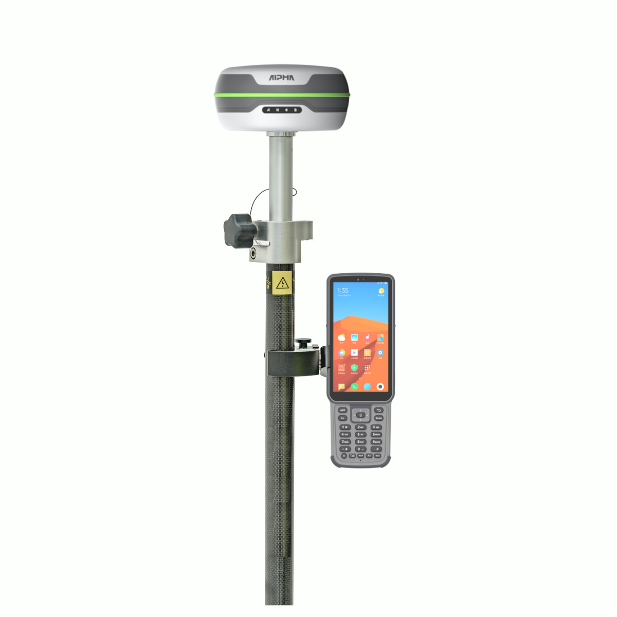
Alpha 5i RTK GNSS Rover Set with Controller and IMU Tilt
This product is available
Get the best price for your setup
Contact our experts for the best possible price and configuration.
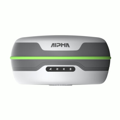
The Alpha 5i Rover Set is a complete RTK GNSS surveying package for construction layout, topographic surveying, mapping and GIS data collection. It combines the lightweight Alpha 5i receiver with an Alpha Bi field controller, survey pole, controller bracket, UHF antenna, chargers, cables and protective transport cases, providing the main equipment needed to begin rover measurements.
The 1116-channel receiver tracks multiple satellite constellations and frequencies for fast, reliable positioning. Its 60° IMU tilt compensation allows points to be measured without holding the pole perfectly vertical, making work faster beside buildings, fences, trenches and other obstacles. Corrections can be received through an NTRIP network using the integrated 4G modem or from a local base station through the built-in 410–470 MHz UHF radio.
Alpha 5i Rover Set Highlights
| Complete rover package | GNSS receiver, Alpha Bi controller, bracket, survey pole, UHF antenna, chargers, cables and transport cases |
|---|---|
| GNSS channels | 1116 channels with multi-frequency, multi-constellation tracking |
| RTK accuracy | Horizontal ±(8 + 1 ppm) mm and vertical ±(15 + 1 ppm) mm |
| IMU tilt measurement | Up to 60° pole tilt for flexible point collection and stakeout |
| Correction options | 4G NTRIP and integrated 410–470 MHz UHF receive and transmit radio |
| UHF range | Up to 16 km in suitable terrain and radio conditions |
| Receiver working time | Up to 25 hours in rover operation |
| Field protection | IP67 receiver housing with a working temperature from -30°C to +70°C |

Valued customers:










Find RTK Networks
Search NTRIP providers and connect to reliable RTK correction services.
Description
Complete Alpha 5i RTK GNSS Rover Set
The Alpha 5i Rover Set is a ready-to-use field surveying package for professionals who need centimetre-level positioning without assembling a rover system from separate components. It includes the Alpha 5i RTK GNSS receiver, Alpha Bi field controller, controller bracket, GNSS survey pole, UHF antenna, chargers, power cables and protective carrying equipment.
This combination is suitable for land surveyors, construction professionals, engineers, GIS teams and contractors carrying out setting out, topographic measurements, as-built checks, utility mapping and other accurate positioning tasks. The receiver, controller and accessories are matched to work together as a practical mobile rover solution.
Multi-Constellation GNSS Positioning
The Alpha 5i uses a 1116-channel GNSS board that tracks signals from GPS, GLONASS, Galileo, BeiDou, QZSS and SBAS. Multi-frequency tracking gives the receiver access to more satellite observations, supporting quick RTK initialisation and consistent positioning as site conditions change.
In everyday fieldwork, this is valuable when working near buildings, vegetation, machinery or other partial obstructions. No GNSS receiver can measure reliably without sufficient satellite visibility, but using several constellations gives the Alpha 5i more signals from which to calculate its position.
Centimetre-Level RTK Accuracy
With a fixed RTK solution and a suitable correction source, the receiver provides specified horizontal accuracy of ±(8 + 1 ppm) mm and vertical accuracy of ±(15 + 1 ppm) mm. This level of positioning is suitable for construction stakeout, topographic surveys, site control, earthwork checks, asset collection and many other professional measurement tasks.
The rover can obtain correction data through a mobile NTRIP service or from a compatible local GNSS base station. This allows the same rover set to be used on projects with access to a correction network and on independent base-and-rover jobsites.
60 Degree IMU Tilt Compensation
The integrated IMU allows measurements to be collected with the survey pole tilted by up to 60°. The operator can place the pole tip on the required point without spending time carefully centring the bubble for every observation.
This is especially useful when measuring against walls, beside fences, near parked equipment or at the edge of an excavation. It can also make repetitive construction stakeout and GIS collection more comfortable because the pole does not need to remain perfectly vertical during every measurement.
Tilt compensation helps improve field efficiency, but good surveying practice remains important. The pole height must be entered correctly, the IMU must be properly initialised and the receiver must have a suitable fixed position before accurate points are stored.
Integrated UHF and 4G Corrections
The Alpha 5i includes a 410–470 MHz UHF transceiver that can both transmit and receive correction data. Under suitable terrain, antenna placement and radio conditions, the specified working range can reach up to 16 km. This makes the rover suitable for use with a local Alpha base receiver on larger construction, infrastructure and land-surveying projects.
Actual UHF range is affected by hills, buildings, vegetation, interference, antenna height and permitted radio power. A base station positioned in a clear and elevated location will normally provide a more reliable connection than one placed close to ground level or behind major obstructions.
Where an NTRIP correction network is available, the integrated 4G modem allows the receiver to obtain corrections over the mobile network. This can remove the need to establish a local base station for every job, reducing setup time and the amount of equipment transported to site.
Alpha Bi Field Controller
The included Alpha Bi controller provides a dedicated device for operating the rover and managing field data. It features an Android operating system, an eight-core processor, 4 GB of memory, 64 GB of internal storage, 4G connectivity, Bluetooth and a physical keypad designed for field use.
The dedicated measurement key can be used to record points while working in survey or stakeout screens. Physical controls are practical in rain, cold conditions or when the operator is wearing gloves, while the controller bracket keeps the display and keypad accessible on the survey pole.
DiMap Surveying Software
DiMap field software supports the main rover workflow, including project creation, coordinate-system configuration, receiver connection, point collection, stakeout, calibration and data export. Surveyors can organise measurements by project and export collected information for further processing or use in CAD and GIS workflows.
The software and controller provide a single field interface for both measurement and stakeout. This helps construction teams move between recording existing positions and locating proposed design points without changing equipment.
Designed for Full Working Days
The Alpha 5i receiver weighs approximately 780 g, keeping the complete pole setup manageable during long surveying sessions. Its intelligent power system provides up to 25 hours of rover operation, depending on the connection mode, radio use, temperature and other operating conditions.
The receiver is protected to IP67 and has a specified operating temperature range of -30°C to +70°C. This makes it suitable for regular outdoor use on building sites, roads, agricultural land and remote survey locations. The supplied carrying equipment helps keep the receiver, controller and accessories together during transport and storage.
Typical Uses for the Alpha 5i Rover Set
- Construction layout and setting out
- Topographic and detail surveying
- As-built position and level checks
- Road and infrastructure projects
- Utility and GIS asset mapping
- Earthwork, stockpile and volume surveys
- Boundary and land-measurement work
What Is Included
The Alpha 5i Rover Set contains the main components required for mobile RTK surveying. The package includes one Alpha 5i GNSS receiver, one Alpha Bi controller, a controller bracket, a GNSS survey pole with transport bag, a UHF antenna, receiver and controller chargers, power cables and protective carrying equipment.
An RTK correction source is still required to obtain centimetre-level rover positions. Depending on the project, this may be an NTRIP subscription or a compatible GNSS base receiver transmitting corrections by UHF or mobile internet.
Buying and Support from Global GPS Systems
Global GPS Systems can help configure the Alpha 5i Rover Set for the intended country, correction network, coordinate system and field workflow. Support is also available when selecting a compatible base station, NTRIP service or additional surveying accessories.
The Alpha 5i Rover Set is a practical option for buyers seeking a complete GNSS rover package with a field controller, IMU tilt measurement, flexible RTK correction methods and the accessories required for day-to-day surveying and construction work.
Datasheets & Manuals
Datasheets and manuals
Specifications
Alpha 5i Rover Set Specifications
System Overview
| Product Type | Complete multi-constellation, multi-frequency RTK GNSS rover system |
|---|---|
| Receiver Model | Alpha 5i |
| Data Collector | Alpha B55 rugged Android data collector |
| Field Software | DiMap Pro surveying and data-collection software |
| Primary Applications | Land surveying, construction layout, topographic surveying, engineering, boundary mapping, point collection, stakeout and CAD-based fieldwork |
| Rover Correction Methods | Network RTK corrections through the integrated cellular modem or radio corrections through the integrated UHF transceiver |
| GNSS Channels | 1,116 |
| RTK Initialization | Approximately 2 seconds under suitable satellite, correction and operating conditions |
| Integrated Receiver Features | Multi-band GNSS, inertial tilt compensation, UHF transceiver, 4G LTE modem, Bluetooth, internal storage, USB Type-C and status indicators |
GNSS Signal Tracking
| Satellite System | Supported Signals |
|---|---|
| GPS | L1 C/A, L1C, L2C, L2P, L5 |
| BeiDou | B1I, B2I, B3I, B1C, B2a, B2b, ACEBOC |
| GLONASS | G1, G2, G3 |
| Galileo | E1, E5a, E5b, AltBOC, E6 |
| QZSS | L1 C/A, L1C, L2C, L5 |
| SBAS | L1, L5 |
Positioning Accuracy
| Positioning Mode | Horizontal Accuracy | Vertical Accuracy |
|---|---|---|
| High-Precision Static | ±(2.5 + 0.5 × 10⁻⁶ × D) mm | ±(5 + 0.5 × 10⁻⁶ × D) mm |
| RTK | ±(8 + 1 × 10⁻⁶ × D) mm | ±(15 + 1 × 10⁻⁶ × D) mm |
D represents the measured baseline distance. Positioning performance depends on satellite geometry, atmospheric conditions, multipath, baseline length, correction quality and the field environment.
Inertial Tilt Compensation
| Technology | Integrated high-precision inertial navigation system combining GNSS positioning with motion sensors |
|---|---|
| Tilt Compensation Range | 0° to 70° |
| Tilt Accuracy | ±(8 + 0.3 × TILT) mm |
| IMU Update Rate | 400 Hz |
| Typical Tilt Performance | Approximately 2 cm accuracy at a 60° pole tilt under suitable operating conditions |
| Field Benefits | Allows points to be measured without precisely levelling the survey pole and improves access near buildings, covered points, dense vegetation, hazardous locations and other obstructions |
Receiver System and Data
| Receiver Operating System | Linux |
|---|---|
| Internal Storage | 8 GB |
| GNSS Data Recording | RINEX |
| Bluetooth | Bluetooth 5.0 |
| Status Indicators | Satellite, data-link, Bluetooth and battery indicator lights |
| Operating Modes | RTK rover, network RTK rover, UHF rover and static GNSS data collection |
Receiver Cellular Communications
| Network Type | Supported Bands |
|---|---|
| GSM | B2, B3, B5, B8 |
| UMTS | B1, B2, B4, B5, B6, B8, B19 |
| LTE-TDD | B38, B39, B40, B41 |
| LTE-FDD | B1, B2, B3, B4, B5, B7, B8, B12, B13, B18, B19, B20, B25, B26, B28 |
Integrated UHF Radio
| Radio Type | Integrated UHF radio transceiver |
|---|---|
| Frequency Range | 410 to 470 MHz |
| Operating Modes | Receive and transmit |
| Transmit Power | Selectable 1 W or 2 W |
| Maximum Stated Range | Up to 16 km under suitable line-of-sight, interference and radio conditions |
| Antenna Connection | TNC connector for the UHF antenna |
Receiver Ports and Controls
| USB Port | USB Type-C |
|---|---|
| USB Functions | Charging and data connection |
| UHF Connector | TNC |
| Wireless Interfaces | Bluetooth 5.0, 4G LTE and UHF radio |
Receiver Power
| Input Voltage | 6 to 28 V DC |
|---|---|
| Charging Standard | QC 2.0 |
| Maximum Stated Operating Time | Up to 25 hours |
| Power Management | Integrated intelligent electronic power-management system |
Receiver Physical Specifications
| Dimensions | 138 × 68 mm |
|---|---|
| Weight | 780 g |
| Construction | Compact rugged field enclosure with integrated GNSS antenna, communications hardware and inertial sensors |
Receiver Environmental Specifications
| Operating Temperature | -30°C to +70°C |
|---|---|
| Storage Temperature | -40°C to +80°C |
| Ingress Protection | IP67 |
| Drop and Shock Resistance | Designed to survive a 2 m drop onto a concrete floor and a 1.2 m free drop |
| Operating Humidity | Up to 100% |
Alpha B55 Data Collector Performance
| Operating System | Android 11 |
|---|---|
| Processor | Octa-core, 2.0 GHz |
| Memory | 4 GB RAM |
| Internal Storage | 64 GB |
| Expandable Storage | MicroSD card support up to 256 GB |
| CAD Processing | Designed to process CAD files larger than 100 MB, multiple layers, multiple text encodings and field drawing functions |
Alpha B55 Display and Input
| Display Size | 5.5 inches |
|---|---|
| Display Resolution | 720 × 1440 pixels |
| Physical Keyboard | Integrated field keypad |
| Measurement Key | Dedicated red measurement button |
| Rear Camera | 13-megapixel autofocus camera |
| Audio | Integrated speaker rated at 95 dB ±3 dB and one microphone |
Alpha B55 Wireless Connectivity
| Interface | Specification |
|---|---|
| Wi-Fi | IEEE 802.11 a/b/g/n/ac, 2.4 GHz and 5 GHz |
| Bluetooth | Bluetooth 5.0 with Bluetooth Low Energy |
| GSM | B2, B3, B5, B8 |
| WCDMA | B1, B2, B5, B8 |
| FDD-LTE | B1, B3, B5, B7, B8 |
| TDD-LTE | B38, B39, B40, B41 |
| CDMA/EVDO | BC0, BC1 |
| SIM Support | Dual-SIM card slots |
| NFC | ISO 14443A/B and ISO 15693; operating distance up to approximately 5 cm |
Alpha B55 Ports and Power
| USB Interface | USB Type-C |
|---|---|
| USB Features | USB OTG and fast charging |
| Battery | 3.7 V, 7,700 mAh rechargeable battery |
| Memory Card Slot | Supports cards up to 256 GB |
Alpha B55 Physical and Environmental Specifications
| Dimensions | 221 × 77.7 × 16 mm |
|---|---|
| Weight | 335 g |
| Ingress Protection | IP67 |
| Drop Resistance | 1.5 m onto hard ground |
| Operating Temperature | -20°C to +55°C |
| Storage Temperature | -30°C to +70°C |
| Operating Humidity | 5% to 95% |
DiMap Pro Surveying Software
| Software Type | Android field-surveying, stakeout and GNSS data-collection software |
|---|---|
| Point Survey | Supported |
| Detail Survey | Supported |
| Control Point Survey | Supported |
| Point Stakeout | Supported |
| CAD Mapping | Supported |
| Road Stakeout | Supported |
| Polyline and Polygon Survey | Supported |
| Spiral Stakeout | Supported |
| DSM Stakeout | Supported |
| Electric Line Survey | Supported |
| Electric Tower Stakeout | Supported |
| Photovoltaic Stakeout | Supported |
| In-Field Data Review | Measurement data can be viewed and checked during field operations |
Rover Set Package Contents
| Item | Quantity | Notes |
|---|---|---|
| Alpha 5i GNSS Receiver | 1 | Multi-frequency RTK rover with IMU, cellular modem and integrated UHF radio |
| Alpha B55 Data Collector | 1 | Rugged Android field controller |
| DiMap Pro Software | 1 | Field-surveying and stakeout software for the controller |
| Telescopic GNSS Pole | 1 | Survey pole for rover operation |
| GNSS Pole Bag | 1 | Transport bag for the survey pole |
| Controller Bracket | 1 | Mounts the Alpha B55 to the survey pole |
| Receiver Charger | 1 | Charger for the Alpha 5i receiver |
| Receiver Power Cable | 1 | Receiver charging and power cable |
| UHF Antenna | 1 | Antenna for the integrated 410 to 470 MHz radio |
| Controller Adapter | 1 | Power adapter for the Alpha B55 |
| Controller USB Cable | 1 | Charging and data cable |
| Carrying Case | 1 | Protective transport case for the receiver and accessories |
Specifications and package contents may vary by configuration, region or manufacturer update. Always check the current configuration before ordering.
FAQ
Alpha 5i Rover Set FAQ
Rover Set Overview and Applications
What is the Alpha 5i Rover Set?
The Alpha 5i Rover Set is a complete RTK GNSS surveying package built around the Alpha 5i receiver. It combines the receiver with a field controller, surveying software, telescopic pole and controller bracket for high-precision data collection and stakeout work.
Who is the Alpha 5i Rover Set designed for?
The set is designed for land surveyors, construction teams, civil engineers, utility crews, GIS professionals and other field users who need centimetre-level positioning with a portable, single-operator GNSS system.
What surveying tasks can be completed with this rover set?
The Alpha 5i Rover Set can be used for topographic surveys, construction layout, point stakeout, cadastral measurements, as-built surveys, earthworks, infrastructure projects, road surveying, utility mapping and GIS data collection.
Is the Alpha 5i Rover Set suitable for construction work?
Yes. The set is suitable for construction layout, checking positions and elevations, recording completed work and collecting site measurements. Its IMU tilt compensation can also make it easier to measure points close to walls, machinery or other obstructions.
Can one person operate the Alpha 5i Rover Set?
Yes. The receiver, controller and software are designed to support efficient one-person surveying. The operator can collect points, stake out coordinates and manage project data directly from the field controller.
What is the difference between the Alpha 5i Rover Set and the Alpha 5i receiver?
The standalone Alpha 5i product primarily includes the GNSS receiver and its standard accessories. The Rover Set adds the field equipment needed for a practical surveying workflow, including the Alpha B55 data collector, DiMap Pro software, telescopic pole and controller bracket.
Accuracy, Satellites and IMU Tilt
What accuracy can the Alpha 5i Rover Set achieve?
The Alpha 5i is designed to deliver centimetre-level RTK positioning, with up to approximately 2 cm accuracy under suitable conditions. Actual accuracy depends on correction quality, satellite geometry, distance from the reference station, multipath and the surrounding environment.
Does the Alpha 5i Rover Set require RTK corrections?
Yes. Centimetre-level real-time positioning requires correction data from a compatible GNSS base station or an internet-based RTK network. Without RTK corrections, the receiver can still calculate a position, but it will not normally achieve the same level of accuracy.
Which satellite systems does the Alpha 5i support?
The receiver supports multiple frequencies from GPS, GLONASS, Galileo and BeiDou. Tracking several satellite constellations helps improve availability, initialization and positioning performance in areas with partial sky obstruction.
How many GNSS channels does the Alpha 5i have?
The Alpha 5i has 1,116 GNSS channels, allowing it to track multiple satellite constellations and signal frequencies simultaneously.
What does the IMU tilt sensor do?
The integrated IMU compensates for the angle of the survey pole, allowing points to be measured without holding the pole perfectly vertical. This can improve field efficiency and make difficult points easier to reach.
How far can the survey pole be tilted?
The Alpha 5i supports tilt-compensated measurements at pole angles of up to approximately 60 degrees. Accuracy depends on correct initialization, an accurate pole-height setting and suitable GNSS conditions.
Corrections, Connectivity and Software
Can the Alpha 5i Rover Set connect to an NTRIP correction network?
Yes. The receiver includes a 4G internet modem and can connect to a compatible NTRIP or CORS correction service through the field software. A suitable SIM card, mobile data connection and valid correction-service credentials are required.
Does the Alpha 5i have a built-in UHF radio?
Yes. The receiver has an integrated UHF radio operating in the 410–470 MHz frequency range. It can receive compatible correction data directly from a GNSS base station.
What is the maximum UHF radio range?
The specified UHF radio range is up to 16 km in favourable line-of-sight conditions. The practical range can be reduced by terrain, vegetation, buildings, interference, antenna placement and local transmission-power restrictions.
Can this rover set work without mobile internet?
Yes. When a compatible local base station is transmitting corrections by UHF radio, the rover can operate without a mobile internet connection. Mobile internet is normally required when corrections are received through an NTRIP network.
Which controller is included with the Alpha 5i Rover Set?
The set includes the Alpha B55 data collector. It is used to configure the GNSS receiver, manage survey projects, enter pole heights, collect points, perform stakeout work and review field data.
Which surveying software is included?
The Alpha 5i Rover Set includes DiMap Pro field software. The software supports common RTK workflows such as project creation, coordinate-system configuration, point surveying, stakeout and field data management.
Can survey data be exported for use in other software?
DiMap Pro is designed to import and export commonly used surveying data formats. Available formats and workflows may depend on the software version, project configuration and the office software used to process the measurements.
Package Contents, Setup and Field Use
What is included with the Alpha 5i Rover Set?
The rover set includes the Alpha 5i RTK GNSS receiver, Alpha B55 data collector, DiMap Pro software, telescopic survey pole and controller bracket. Receiver and controller charging accessories and other standard components may also be supplied with the selected configuration.
Can the components in the rover set be customised?
Yes. Compatible components such as the telescopic pole, controller bracket or other accessories can be changed to suit a particular workflow. The required configuration should be confirmed before ordering.
Is a GNSS base station included?
No. This is a rover set and does not normally include a separate GNSS base receiver. It is intended to receive corrections from an existing base station or an NTRIP correction network. Users who need both receivers should consider a rover-base set.
Is an RTK network subscription included?
Access to an NTRIP or CORS correction service depends on the selected configuration and the services available in the user’s region. A separate account, licence or subscription may be required.
How is the Alpha 5i Rover Set prepared for surveying?
Mount the receiver on the survey pole, attach the controller to the bracket, connect the controller to the receiver, select the required coordinate system and correction source, enter the correct pole height and wait for a fixed RTK solution before recording points.
Can the Rover Set be used in difficult terrain?
Yes. The lightweight pole-based setup and IMU tilt compensation are useful on slopes, uneven ground and around obstacles. GNSS performance may still be affected by dense trees, tall buildings, reflective surfaces or locations with limited satellite visibility.
Reviews (0)
Only logged in customers who have purchased this product may leave a review.
 GPS & GNSS
 Total Stations
 Data collectors
 Software
 Correction services
 Machine control
 External radio
 Lasers & levellers
 Marine
 Accessories
Reviews
There are no reviews yet