

 GPS & GNSS
 Lidar scanning
 Total Station
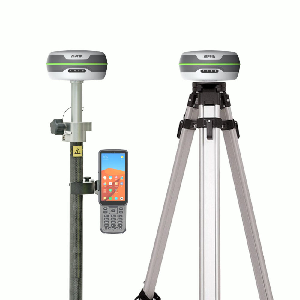
Alpha 5i RTK GNSS Rover Base Set with IMU and Controller
Get the best price for your setup
Contact our experts for the best possible price and configuration.
- Fast response
- Expert configuration advice
- No overpaying for features you do not need
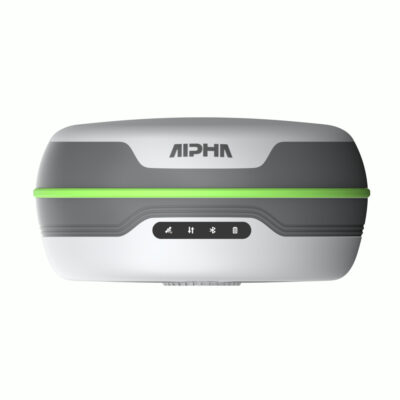
The Alpha 5i Rover Base Set is a complete two-receiver RTK GNSS surveying system for construction layout, land surveying, engineering and GIS work. One Alpha 5i receiver operates as the fixed base station and sends correction data to the second receiver used as the rover, allowing centimetre-level field measurements without depending on a third-party RTK network.
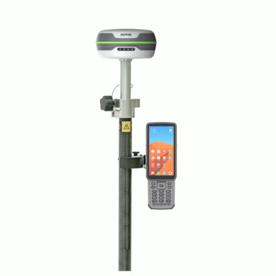
Both Alpha 5i receivers use 1116-channel, multi-frequency GNSS technology and an integrated 410–470 MHz UHF transceiver. The rover’s 60° IMU tilt compensation allows users to collect or stake out points without holding the pole perfectly vertical. The package also includes an Alpha B55 field controller, DiMap Pro surveying software, a survey pole and controller bracket, plus a tripod, tribrach and adapter for stable base-station setup.
Alpha 5i Rover Base Set Highlights
| System configuration | Two Alpha 5i GNSS receivers configured as one base and one rover |
|---|---|
| GNSS channels | 1116-channel multi-frequency and multi-constellation tracking |
| RTK accuracy | Horizontal ±(8 + 1 ppm) mm and vertical ±(15 + 1 ppm) mm |
| IMU tilt measurement | Up to 60° pole tilt for flexible rover measurement and stakeout |
| Base-to-rover radio | Integrated 410–470 MHz UHF transmit and receive radio |
| Specified UHF range | Up to 16 km under suitable terrain, antenna and radio conditions |
| Field controller | Alpha B55 controller with DiMap Pro surveying software |
| Base equipment | Tripod, tribrach and adapter for stable receiver positioning |
| Receiver protection | IP67 enclosure and operating temperature from -30°C to +70°C |
Valued customers:










Find RTK Networks
Search NTRIP providers and connect to reliable RTK correction services.
Description
Complete Alpha 5i RTK GNSS Rover and Base System
The Alpha 5i Rover Base Set is a complete RTK GNSS package for professionals who need to establish their own local correction source. The set uses two Alpha 5i receivers: one receiver is installed on a fixed point as the base station, while the second receiver is mounted on the survey pole and used as the rover.
The base calculates correction data from its fixed position and transmits that information to the moving rover through the integrated UHF radio. This arrangement allows surveyors, engineers and construction teams to obtain centimetre-level positions in areas where no NTRIP network is available, where mobile coverage is unreliable or where a dedicated project base is preferred.
Independent RTK Working Without a Correction Subscription
A rover-only system requires access to an existing base station or an online RTK correction network. This package includes both GNSS receivers, giving the user control over the complete base-to-rover workflow. It is well suited to remote projects, temporary construction sites, agricultural land, roadworks and other locations where external correction services may be unavailable.
Before surveying begins, the base receiver must be positioned securely over a suitable reference point. The operator then configures the coordinate system, base coordinates and UHF transmission settings through the field software. Once the rover receives the corrections and obtains a fixed RTK solution, it can be used for point collection, setting out and site checks.
1116-Channel Multi-Constellation GNSS
Each Alpha 5i receiver uses an 1116-channel GNSS board capable of tracking signals from GPS, GLONASS, Galileo, BeiDou, QZSS and SBAS. Its multi-frequency design gives the system access to a large number of satellite observations and supports quick RTK initialisation in suitable working conditions.
In practical fieldwork, broader satellite tracking helps when visibility changes because of nearby buildings, machinery, trees or terrain. Clear sky visibility is still important, especially at the base station, but using several constellations gives the receivers more signals from which to calculate their positions.
Centimetre-Level RTK Surveying
With the base correctly configured and the rover operating with a fixed solution, the Alpha 5i has specified RTK accuracy of ±(8 + 1 ppm) mm horizontally and ±(15 + 1 ppm) mm vertically. This makes the set suitable for construction layout, topographic surveys, as-built measurements, utility mapping, boundary work and earthwork checks.
The final result depends on correct field procedures as well as receiver performance. The base must remain stable, its coordinates must be entered correctly and the rover’s solution status should be checked before important points are recorded. Measuring a known check point at the start of the job is a practical way to confirm that the project setup and coordinate transformation are correct.
60 Degree IMU Tilt Compensation
The rover receiver includes IMU tilt compensation for measurements with the survey pole tilted by up to 60°. Instead of carefully levelling the pole for every point, the operator can place the pole tip on the required position and measure while the system compensates for the pole angle.
This is useful beside walls, fences, structures, trenches, stockpiles and other obstacles that make it difficult to hold the receiver directly above a point. Tilt compensation can also speed up repetitive construction stakeout because less time is spent centring the pole bubble before each observation.
For dependable results, the correct pole height must be entered, the IMU must be initialised as required and the rover must maintain a suitable fixed GNSS solution.
Integrated Long-Range UHF Radio
Both Alpha 5i receivers contain a 410–470 MHz UHF transceiver capable of transmitting and receiving correction data. In the base-and-rover configuration, the base sends corrections directly to the rover without relying on mobile internet.
The stated radio range is up to 16 km under suitable conditions. Real working range depends on permitted transmission power, antenna type, base height, terrain, vegetation, buildings and local interference. Installing the base in an open and elevated position generally provides a more dependable radio link than placing it close to the ground or behind large obstructions.
Radio frequencies and permitted power levels vary by country. The system should therefore be configured for the regulations that apply in the area where it will be used.
Alpha B55 Field Controller and DiMap Pro
The included Alpha B55 data collector is used to configure the receivers, manage projects and record field measurements. Its physical keypad and dedicated measurement controls are practical for outdoor work, particularly when operators are wearing gloves or working in rain and cold conditions.
DiMap Pro surveying software supports project creation, coordinate-system selection, base and rover configuration, point collection, stakeout, calibration and data export. This allows the same controller to manage both the setup of the correction source and the daily rover workflow.
Survey data can be organised by project and exported for further work in compatible CAD, engineering or GIS applications. The available format and transfer workflow should be checked against the office software used by the surveying team.
Stable Base-Station Setup
The supplied tripod, tribrach and adapter provide a stable platform for the base receiver. A secure setup is essential because any movement of the base after surveying begins can affect every point measured by the rover.
For longer projects, the base can be installed over a known control point so measured rover coordinates correspond directly with the project coordinate system. When the base is established on an unknown position, a site calibration or coordinate transformation may be required before accurate project coordinates can be used.
Designed for Demanding Field Conditions
Each Alpha 5i receiver weighs approximately 780 g and has an IP67-rated enclosure for protection against dust and temporary water exposure. The specified working temperature range is -30°C to +70°C, supporting everyday use on construction sites, infrastructure projects and remote survey locations.
The receiver offers up to 25 hours of operation in rover mode, depending on radio use, mobile connectivity, temperature and other operating conditions. Protective cases help keep the receivers, controller, antennas, chargers and accessories organised during storage and transport.
Typical Applications
- Construction layout and machine-position checks
- Topographic and detail surveying
- Road, railway and infrastructure projects
- Earthwork, stockpile and volume measurements
- Utility and GIS asset mapping
- Boundary and cadastral fieldwork
- As-built surveys and progress documentation
- Remote surveying without an available NTRIP network
What Is Included
The package is built around two Alpha 5i GNSS receivers and includes an Alpha B55 data collector with DiMap Pro surveying software. Rover equipment includes a GNSS survey pole and controller bracket. Base-station equipment includes a tripod, tribrach and adapter. Receiver antennas, chargers, cables and protective carrying equipment are also supplied according to the selected package configuration.
Because available accessories can be adjusted for different workflows, buyers should confirm the final packing list, pole type, controller version, radio configuration and required adapters when ordering.
Buying and Support from Global GPS Systems
Global GPS Systems can help configure the Alpha 5i Rover Base Set for the intended country, radio frequencies, coordinate system and field workflow. Support is also available when selecting accessories, preparing the base-and-rover radio link and choosing an appropriate method for establishing the base coordinates.
The Alpha 5i Rover Base Set is a practical option for construction teams, surveyors and engineers who need a transportable, independent RTK system with two multi-frequency receivers, IMU-assisted rover measurement and a dedicated field controller.
Specifications
Alpha 5i Rover Base Set Specifications
System Overview
| Product Type | Complete multi-constellation, multi-frequency RTK GNSS rover-and-base surveying system |
|---|---|
| GNSS Receivers | 2 × Alpha 5i RTK GNSS receivers configured as one rover and one base station |
| Data Collector | Alpha B55 rugged Android data collector |
| Field Software | DiMap Pro GNSS surveying and stakeout software |
| Correction Link | Integrated UHF radio communication between the base and rover |
| Alternative Rover Corrections | Network RTK corrections through the receiver or controller cellular connection, subject to compatible NTRIP service and configuration |
| GNSS Channels per Receiver | 1,116 |
| RTK Initialization | Approximately 2 seconds under suitable satellite, correction-link and operating conditions |
| Maximum Stated UHF Range | Up to 16 km under suitable line-of-sight and radio conditions |
| Primary Applications | Land surveying, construction layout, topographic surveying, engineering surveys, boundary mapping, control surveys, point collection, stakeout and CAD-based fieldwork |
Base and Rover Configuration
| Component | Base Receiver | Rover Receiver |
|---|---|---|
| Receiver Model | Alpha 5i | Alpha 5i |
| Primary Function | Generates and transmits GNSS correction data from a fixed position | Receives correction data and calculates real-time centimetre-level positions |
| Typical Mounting | Tripod, tribrach and receiver adapter | Telescopic GNSS survey pole |
| UHF Operation | Transmit | Receive |
| Cellular Operation | Supported where required by the selected workflow | Supported for network RTK operation |
| Static Data Collection | Supported | Supported |
| IMU Tilt Compensation | Integrated; normally used when operating the receiver as a rover | Integrated |
GNSS Signal Tracking
| Satellite System | Supported Signals |
|---|---|
| GPS | L1 C/A, L1C, L2C, L2P, L5 |
| BeiDou | B1I, B2I, B3I, B1C, B2a, B2b, ACEBOC |
| GLONASS | G1, G2, G3 |
| Galileo | E1, E5a, E5b, AltBOC, E6 |
| QZSS | L1 C/A, L1C, L2C, L5 |
| SBAS | L1, L5 |
Positioning Accuracy
| Positioning Mode | Horizontal Accuracy | Vertical Accuracy |
|---|---|---|
| High-Precision Static | ±(2.5 + 0.5 × 10⁻⁶ × D) mm | ±(5 + 0.5 × 10⁻⁶ × D) mm |
| RTK | ±(8 + 1 × 10⁻⁶ × D) mm | ±(15 + 1 × 10⁻⁶ × D) mm |
D represents the measured baseline distance. Accuracy depends on satellite geometry, multipath, atmospheric conditions, baseline length, correction quality, radio or internet connectivity and the surrounding field environment.
Inertial Tilt Compensation
| Technology | Integrated high-precision inertial navigation system combining GNSS positioning with motion-sensor data |
|---|---|
| Tilt Compensation Range | 0° to 70° |
| Specified Tilt Accuracy | ±(8 + 0.3 × TILT) mm |
| IMU Update Rate | 400 Hz |
| Stated Performance at 60° Tilt | Approximately 2 cm under suitable operating conditions |
| Pole Levelling Requirement | Allows compensated point measurement without holding the survey pole precisely vertical |
| Typical Use Cases | Measurements near buildings, walls, covered points, dense vegetation, hazardous points and other locations where vertical pole positioning is difficult |
| IMU Reinitialization | May be required after receiver inversion, intense shaking or other disruptive movement |
Receiver System and Data
| Receiver Operating System | Linux |
|---|---|
| Internal Storage | 8 GB |
| GNSS Data Recording | RINEX |
| Bluetooth | Bluetooth 5.0 |
| SIM Card Slot | Integrated |
| Receiver Self-Test | Integrated module self-test function with audible status indication |
| Status Indicators | Power, satellite, data-link and Bluetooth status lights |
| Supported Workflows | UHF base and rover, network RTK rover, static data collection, point survey and stakeout |
Receiver Cellular Communications
| Network Type | Supported Bands |
|---|---|
| GSM | B2, B3, B5, B8 |
| UMTS | B1, B2, B4, B5, B6, B8, B19 |
| LTE-TDD | B38, B39, B40, B41 |
| LTE-FDD | B1, B2, B3, B4, B5, B7, B8, B12, B13, B18, B19, B20, B25, B26, B28 |
Integrated UHF Radio
| Radio Type | Integrated UHF transceiver in each Alpha 5i receiver |
|---|---|
| Frequency Range | 410 to 470 MHz |
| Operating Modes | Receive and transmit |
| Transmit Power | Selectable 1 W or 2 W |
| Maximum Stated Range | Up to 16 km under suitable line-of-sight, antenna, terrain, interference and regulatory conditions |
| Antenna Connector | TNC |
| Base-to-Rover Operation | The base receiver transmits correction data to the rover receiver over the configured UHF channel |
Receiver Ports and Controls
| USB Port | USB Type-C |
|---|---|
| USB Functions | Charging and data connection |
| UHF Antenna Port | TNC connector |
| Power Control | Integrated power button |
| Height Reference | Receiver enclosure includes a height-measurement reference line |
| Wireless Interfaces | Bluetooth 5.0, 4G LTE and integrated UHF radio |
Receiver Power
| Input Voltage | 6 to 28 V DC |
|---|---|
| Charging Standard | QC 2.0 |
| Maximum Stated Operating Time | Up to 25 hours per receiver |
| Power Management | Integrated intelligent electronic power-management system |
| Battery Status Indication | LED indication for normal power, low battery and charging status |
Receiver Physical Specifications
| Dimensions | 138 × 68 mm |
|---|---|
| Weight | 780 g per receiver |
| Construction | Compact rugged field enclosure with integrated GNSS antenna, radio, cellular modem, battery and inertial sensors |
Receiver Environmental Specifications
| Operating Temperature | -30°C to +70°C |
|---|---|
| Storage Temperature | -40°C to +80°C |
| Ingress Protection | IP67 dust and water protection |
| Shock Resistance | Specified to survive a 2 m drop onto a concrete floor and a 1.2 m free drop |
| Operating Humidity | Up to 100% |
Alpha B55 Data Collector Platform
| Operating System | Android 11 |
|---|---|
| Processor | Octa-core, 2.0 GHz |
| Memory | 4 GB RAM |
| Internal Storage | 64 GB |
| Expandable Storage | MicroSD card support up to 256 GB |
| Display Size | 5.5 inches |
| Display Resolution | 720 × 1440 pixels |
| Rear Camera | 13-megapixel autofocus camera |
| Physical Input | Integrated field keypad with dedicated measurement button |
| CAD Capability | Designed for field use with large CAD drawings, multiple layers, multiple text encodings and drawing functions |
Alpha B55 Wireless Connectivity
| Interface | Specification |
|---|---|
| Wi-Fi | IEEE 802.11 a/b/g/n/ac, 2.4 GHz and 5 GHz |
| Bluetooth | Bluetooth 5.0 with Bluetooth Low Energy |
| FDD-LTE | B1, B3, B5, B7, B8 |
| TDD-LTE | B38, B39, B40, B41 |
| WCDMA | B1, B2, B5, B8 |
| GSM | B2, B3, B5, B8 |
| CDMA/EVDO | BC0, BC1 |
| SIM Support | Dual-SIM card slots |
| NFC | ISO 14443A/B and ISO 15693; operating distance up to approximately 5 cm |
Alpha B55 Audio, Ports and Power
| USB Interface | USB Type-C |
|---|---|
| USB Functions | USB OTG, charging and data transfer |
| Fast Charging | Supported |
| Battery | 3.7 V, 7,700 mAh rechargeable battery |
| Speaker | 95 dB ±3 dB |
| Microphone | 1 integrated microphone |
Alpha B55 Physical and Environmental Specifications
| Dimensions | 221 × 77.7 × 16 mm |
|---|---|
| Weight | 335 g |
| Ingress Protection | IP67 |
| Drop Resistance | 1.5 m onto hard ground |
| Operating Temperature | -20°C to +55°C |
| Storage Temperature | -30°C to +70°C |
| Operating Humidity | 5% to 95% |
DiMap Pro Surveying Software
| Software Type | Android GNSS field-surveying, mapping and stakeout software |
|---|---|
| Receiver Configuration | Bluetooth connection and configuration of Alpha GNSS receivers |
| Base Configuration | Base coordinates, correction transmission and data-link configuration |
| Rover Configuration | Correction reception, RTK status and rover-mode configuration |
| Project Management | Project creation, coordinate-system selection and project-data management |
| Point Survey | Supported |
| Detail Survey | Supported |
| Control Point Survey | Supported |
| Point Stakeout | Supported |
| CAD Mapping | Supported |
| Road Stakeout | Supported |
| Polyline and Polygon Survey | Supported |
| Spiral Stakeout | Supported |
| DSM Stakeout | Supported |
| Electric Line Survey | Supported |
| Electric Tower Stakeout | Supported |
| Photovoltaic Stakeout | Supported |
| Coordinate Transformation | Transformation-parameter calculation and point calibration |
| Data Review | Measurement data can be viewed and checked during field operations |
| Data Export | Field data can be exported in selectable survey formats and transferred through USB |
Rover Base Set Package Contents
| Item | Quantity | Notes |
|---|---|---|
| Alpha 5i GNSS Receiver | 2 | One receiver for base operation and one receiver for rover operation |
| Alpha B55 Data Collector | 1 | Rugged Android controller for receiver configuration, surveying and stakeout |
| DiMap Pro Software | 1 license | Installed or supplied for use with the data collector |
| Telescopic GNSS Survey Pole | 1 | For rover operation |
| Survey Pole Bag | 1 | Protective transport bag for the rover pole |
| Data Collector Bracket | 1 | Mounts the Alpha B55 to the rover pole |
| Survey Tripod | 1 | Supports the base receiver assembly |
| Tribrach | 1 | Levelling and centring component for the base setup |
| Tribrach or Receiver Adapter | 1 | Connects the base receiver to the tribrach and tripod assembly |
| Receiver Chargers | 2 | One charger for each Alpha 5i receiver |
| Receiver Power Cables | 2 | Charging and data cables for the receivers |
| UHF Antennas | 2 | For base transmission and rover reception through the integrated radios |
| Data Collector Adapter | 1 | Power adapter for the Alpha B55 |
| Data Collector USB Cable | 1 | Charging and data-transfer cable |
| Receiver Carrying Cases | 2 | Protective cases for the receivers and associated accessories |
Specifications and package contents may vary by configuration, region or manufacturer update. Always check the current configuration before ordering.
Reviews (0)
Only logged in customers who have purchased this product may leave a review.
FAQ
Alpha 5i Rover Base Set FAQ
System Overview and Applications
What is the Alpha 5i Rover Base Set?
The Alpha 5i Rover Base Set is a complete RTK GNSS surveying system with Alpha 5i receivers configured as a base station and rover. The base generates correction data, while the rover uses those corrections to provide centimetre-level positioning in the field.
Who is the Alpha 5i Rover Base Set designed for?
The set is designed for land surveyors, construction contractors, civil engineers, utility crews, mapping professionals and other users who need an independent high-accuracy GNSS solution for field measurement and stakeout work.
What work can be completed with this rover and base set?
The system can be used for topographic surveys, construction layout, cadastral measurements, control surveys, road stakeout, earthworks, as-built surveys, utility mapping, volume calculations and other high-precision positioning tasks.
What is the advantage of a rover and base set?
A rover and base set allows users to create their own local RTK correction source instead of relying entirely on a third-party correction network. This is useful in remote locations, areas without reliable mobile internet and projects where full control over the reference position is required.
Can the Alpha 5i receivers change between base and rover roles?
Yes. Each Alpha 5i includes a UHF transceiver capable of receiving and transmitting data, so the receivers can be configured for base or rover operation through the field software.
Can one person operate the Alpha 5i Rover Base Set?
Yes. After the base station has been installed and started, one operator can use the rover, controller and survey pole to collect or stake out points. The base should remain stable and undisturbed throughout the survey.
Accuracy, Satellites and Tilt Compensation
What RTK accuracy can the Alpha 5i achieve?
The specified RTK accuracy is ±(8 + 1 ppm) mm horizontally and ±(15 + 1 ppm) mm vertically under suitable conditions. Actual field accuracy depends on satellite geometry, base coordinates, baseline length, radio quality, multipath and the surrounding environment.
How quickly can the Alpha 5i obtain a fixed RTK solution?
The Alpha 5i is designed to obtain an RTK fixed solution in approximately two seconds when it has suitable satellite visibility and is receiving valid correction data. Initialization may take longer near trees, buildings or other signal obstructions.
Which GNSS constellations does the Alpha 5i support?
The receiver supports signals from GPS, GLONASS, Galileo, BeiDou, QZSS and SBAS. Multi-constellation and multi-frequency tracking improves satellite availability and helps the system perform in partially obstructed locations.
How many GNSS channels does the Alpha 5i have?
Each Alpha 5i receiver has 1,116 channels for tracking multiple satellite constellations and signal frequencies simultaneously.
What does the Alpha 5i IMU tilt sensor do?
The integrated IMU compensates for the angle of the rover pole, allowing the operator to measure points without keeping the pole perfectly vertical. This is useful beside walls, beneath obstacles, on slopes and at points that are difficult or unsafe to occupy directly.
How far can the rover pole be tilted?
The Alpha 5i is designed to support centimetre-level measurements with the pole tilted by up to approximately 60 degrees. Correct IMU initialization, pole-height entry and a fixed RTK solution are required for reliable results.
Base Station, Corrections and Connectivity
How do the Alpha 5i base and rover communicate?
The base receiver calculates RTK correction data and transmits it through its integrated UHF radio. The rover receives those corrections through its own UHF radio and combines them with satellite observations to calculate a precise position.
What is the maximum UHF radio range?
The integrated UHF radio has a specified range of up to 16 km in favourable open and line-of-sight conditions. Terrain, buildings, vegetation, interference, antenna placement and permitted transmission power can reduce the practical range.
Which UHF frequencies does the Alpha 5i support?
The built-in 1 W/2 W UHF transceiver operates within the 410–470 MHz range and supports both transmitting and receiving. The base and rover must use matching frequencies, protocols and correction settings.
Does the rover and base set require mobile internet?
No. The base can transmit corrections directly to the rover by UHF radio, allowing the system to operate without mobile internet. Internet connectivity may still be used for online maps, file transfer or network-based RTK corrections.
Can the rover also connect to an NTRIP or CORS network?
Yes. The Alpha 5i includes a 4G LTE modem and can receive compatible network corrections through DiMap Pro. A SIM card, mobile data coverage and valid credentials for the selected NTRIP or CORS service are required.
How should the base station coordinates be established?
For repeatable results, the base should be installed over a known control point and configured with its verified coordinates. An averaged autonomous position can be used for relative work, but it may not align accurately with an official coordinate system or previous surveys.
Does the rover require calibration when the base position changes?
A site calibration or translation check may be required when a local base is restarted at a different position or with different starting coordinates. DiMap Pro includes localization and point-calibration tools for aligning GNSS measurements with known project control.
Software, Package Contents and Field Operation
What equipment is included with the Alpha 5i Rover Base Set?
The set is configured with Alpha 5i equipment for rover and base operation, an Alpha B55 data collector, DiMap Pro surveying software, a survey pole, controller bracket, tripod, tribrach and adapter. Charging equipment, UHF antennas and transport cases are also supplied according to the selected configuration. Exact quantities and components should be confirmed before ordering.
Which field software is supplied with the set?
The set includes DiMap Pro surveying software for Android. It supports base and rover configuration, coordinate systems, localization, point collection, control surveys, point and line stakeout, road stakeout, CAD mapping, data import and export, and field calculation tools.
Can the Alpha 5i record raw GNSS observations?
Yes. The Alpha 5i has 8 GB of internal storage and supports GNSS data recording in RINEX format for compatible static surveying and post-processing workflows.
How long does an Alpha 5i receiver operate on one charge?
Each receiver is specified for up to 25 hours of operation. Actual battery life varies with UHF transmission power, 4G use, Bluetooth activity, temperature, battery condition and operating settings. A receiver used as a transmitting base may consume power faster.
Is the Alpha 5i suitable for difficult outdoor conditions?
Yes. The receiver has an IP67 dust and water protection rating and is specified to survive a 2 m pole drop onto concrete or a 1.2 m free drop. Its operating temperature range is -30°C to +70°C.
Are there legal restrictions on using the integrated UHF radio?
Yes. Permitted frequencies, transmission power and licensing requirements differ by country or region. The system must be configured to use locally authorised radio settings, and the operator is responsible for complying with applicable regulations.
Alpha 5i Rover Base Set FAQ
System Overview and Applications
What is the Alpha 5i Rover Base Set?
The Alpha 5i Rover Base Set is a complete RTK GNSS surveying system with Alpha 5i receivers configured as a base station and rover. The base generates correction data, while the rover uses those corrections to provide centimetre-level positioning in the field.
Who is the Alpha 5i Rover Base Set designed for?
The set is designed for land surveyors, construction contractors, civil engineers, utility crews, mapping professionals and other users who need an independent high-accuracy GNSS solution for field measurement and stakeout work.
What work can be completed with this rover and base set?
The system can be used for topographic surveys, construction layout, cadastral measurements, control surveys, road stakeout, earthworks, as-built surveys, utility mapping, volume calculations and other high-precision positioning tasks.
What is the advantage of a rover and base set?
A rover and base set allows users to create their own local RTK correction source instead of relying entirely on a third-party correction network. This is useful in remote locations, areas without reliable mobile internet and projects where full control over the reference position is required.
Can the Alpha 5i receivers change between base and rover roles?
Yes. Each Alpha 5i includes a UHF transceiver capable of receiving and transmitting data, so the receivers can be configured for base or rover operation through the field software.
Can one person operate the Alpha 5i Rover Base Set?
Yes. After the base station has been installed and started, one operator can use the rover, controller and survey pole to collect or stake out points. The base should remain stable and undisturbed throughout the survey.
Accuracy, Satellites and Tilt Compensation
What RTK accuracy can the Alpha 5i achieve?
The specified RTK accuracy is ±(8 + 1 ppm) mm horizontally and ±(15 + 1 ppm) mm vertically under suitable conditions. Actual field accuracy depends on satellite geometry, base coordinates, baseline length, radio quality, multipath and the surrounding environment.
How quickly can the Alpha 5i obtain a fixed RTK solution?
The Alpha 5i is designed to obtain an RTK fixed solution in approximately two seconds when it has suitable satellite visibility and is receiving valid correction data. Initialization may take longer near trees, buildings or other signal obstructions.
Which GNSS constellations does the Alpha 5i support?
The receiver supports signals from GPS, GLONASS, Galileo, BeiDou, QZSS and SBAS. Multi-constellation and multi-frequency tracking improves satellite availability and helps the system perform in partially obstructed locations.
How many GNSS channels does the Alpha 5i have?
Each Alpha 5i receiver has 1,116 channels for tracking multiple satellite constellations and signal frequencies simultaneously.
What does the Alpha 5i IMU tilt sensor do?
The integrated IMU compensates for the angle of the rover pole, allowing the operator to measure points without keeping the pole perfectly vertical. This is useful beside walls, beneath obstacles, on slopes and at points that are difficult or unsafe to occupy directly.
How far can the rover pole be tilted?
The Alpha 5i is designed to support centimetre-level measurements with the pole tilted by up to approximately 60 degrees. Correct IMU initialization, pole-height entry and a fixed RTK solution are required for reliable results.
Base Station, Corrections and Connectivity
How do the Alpha 5i base and rover communicate?
The base receiver calculates RTK correction data and transmits it through its integrated UHF radio. The rover receives those corrections through its own UHF radio and combines them with satellite observations to calculate a precise position.
What is the maximum UHF radio range?
The integrated UHF radio has a specified range of up to 16 km in favourable open and line-of-sight conditions. Terrain, buildings, vegetation, interference, antenna placement and permitted transmission power can reduce the practical range.
Which UHF frequencies does the Alpha 5i support?
The built-in 1 W/2 W UHF transceiver operates within the 410–470 MHz range and supports both transmitting and receiving. The base and rover must use matching frequencies, protocols and correction settings.
Does the rover and base set require mobile internet?
No. The base can transmit corrections directly to the rover by UHF radio, allowing the system to operate without mobile internet. Internet connectivity may still be used for online maps, file transfer or network-based RTK corrections.
Can the rover also connect to an NTRIP or CORS network?
Yes. The Alpha 5i includes a 4G LTE modem and can receive compatible network corrections through DiMap Pro. A SIM card, mobile data coverage and valid credentials for the selected NTRIP or CORS service are required.
How should the base station coordinates be established?
For repeatable results, the base should be installed over a known control point and configured with its verified coordinates. An averaged autonomous position can be used for relative work, but it may not align accurately with an official coordinate system or previous surveys.
Does the rover require calibration when the base position changes?
A site calibration or translation check may be required when a local base is restarted at a different position or with different starting coordinates. DiMap Pro includes localization and point-calibration tools for aligning GNSS measurements with known project control.
Software, Package Contents and Field Operation
What equipment is included with the Alpha 5i Rover Base Set?
The set is configured with Alpha 5i equipment for rover and base operation, an Alpha B55 data collector, DiMap Pro surveying software, a survey pole, controller bracket, tripod, tribrach and adapter. Charging equipment, UHF antennas and transport cases are also supplied according to the selected configuration. Exact quantities and components should be confirmed before ordering.
Which field software is supplied with the set?
The set includes DiMap Pro surveying software for Android. It supports base and rover configuration, coordinate systems, localization, point collection, control surveys, point and line stakeout, road stakeout, CAD mapping, data import and export, and field calculation tools.
Can the Alpha 5i record raw GNSS observations?
Yes. The Alpha 5i has 8 GB of internal storage and supports GNSS data recording in RINEX format for compatible static surveying and post-processing workflows.
How long does an Alpha 5i receiver operate on one charge?
Each receiver is specified for up to 25 hours of operation. Actual battery life varies with UHF transmission power, 4G use, Bluetooth activity, temperature, battery condition and operating settings. A receiver used as a transmitting base may consume power faster.
Is the Alpha 5i suitable for difficult outdoor conditions?
Yes. The receiver has an IP67 dust and water protection rating and is specified to survive a 2 m pole drop onto concrete or a 1.2 m free drop. Its operating temperature range is -30°C to +70°C.
Are there legal restrictions on using the integrated UHF radio?
Yes. Permitted frequencies, transmission power and licensing requirements differ by country or region. The system must be configured to use locally authorised radio settings, and the operator is responsible for complying with applicable regulations.

 GPS & GNSS
 Total Stations
 Data collectors
 Software
 Correction services
 Machine control
 External radio
 Marine
 Accessories
Reviews
There are no reviews yet