
 GPS & GNSS
 Lidar scanning
 Total Station
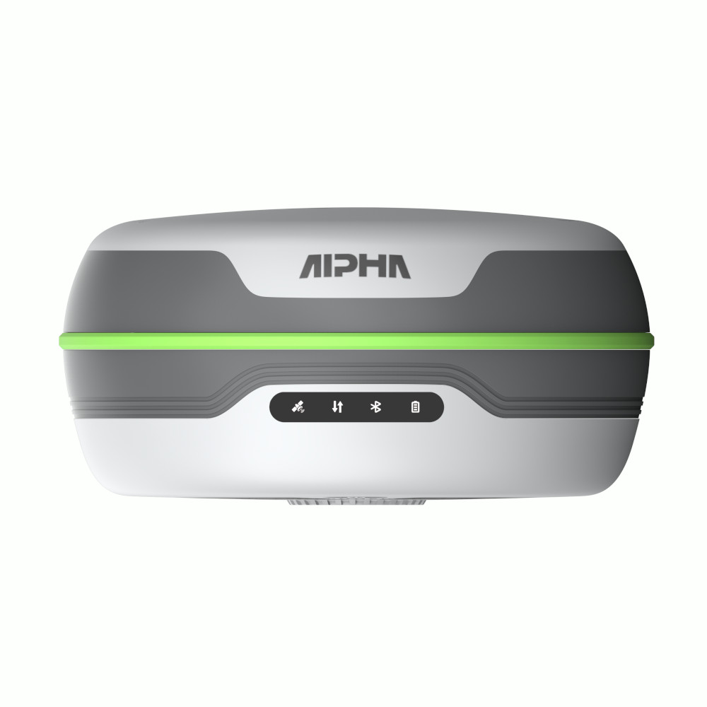
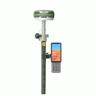
Alpha 5i RTK GNSS Receiver with IMU Tilt
This product is available
Get the best price for your setup
Contact our experts for the best possible price and configuration.
The Alpha 5i is a lightweight RTK GNSS receiver built for accurate surveying, construction layout, mapping and GIS data collection. Its 1116-channel GNSS board tracks multiple satellite constellations and frequencies, helping the receiver establish a fixed position quickly and maintain reliable performance across demanding jobsites.
A 60° IMU tilt sensor allows users to measure points without keeping the survey pole perfectly vertical. This makes stakeout and point collection faster around buildings, fences, trenches, road edges and other locations where positioning the pole directly above the point is difficult. The integrated 410–470 MHz UHF radio supports base-and-rover work over long distances, while the 4G modem enables connection to NTRIP and RTK correction networks.
Alpha 5i Highlights
| GNSS channels | 1116 channels with multi-frequency satellite tracking |
|---|---|
| RTK accuracy | Horizontal ±(8 + 1 ppm) mm and vertical ±(15 + 1 ppm) mm |
| IMU tilt measurement | Up to 60° pole tilt for flexible point collection and stakeout |
| Integrated UHF radio | 410–470 MHz transmit and receive radio with up to 16 km range in favourable conditions |
| Connectivity | 4G LTE, Bluetooth 5.0, UHF and Type-C |
| Working time | Up to 25 hours in rover operation |
| Environmental protection | IP67 water and dust protection with a 780 g receiver weight |

Valued customers:










Find RTK Networks
Search NTRIP providers and connect to reliable RTK correction services.
Description
Alpha 5i RTK GNSS Receiver for Surveying and Construction
The Alpha 5i is a multi-constellation RTK GNSS receiver designed for surveyors, construction professionals, engineers, GIS teams and other users who need centimetre-level positioning in the field. It combines multi-frequency satellite tracking, IMU tilt compensation, an integrated long-range UHF radio and mobile network connectivity in a compact 780 g housing.
Its 1116-channel GNSS board tracks GPS, GLONASS, Galileo, BeiDou, QZSS and SBAS signals. Access to several constellations and frequencies gives the receiver more observations to work with, supporting faster RTK fixing and more consistent positioning when part of the sky is obstructed. This is useful on construction sites, near buildings, along roads and in other working areas where satellite visibility can change throughout the day.
Centimetre-Level RTK Positioning
When used with suitable RTK corrections, the Alpha 5i provides specified horizontal accuracy of ±(8 + 1 ppm) mm and vertical accuracy of ±(15 + 1 ppm) mm. In practical fieldwork, this makes the receiver suitable for topographic surveys, construction layout, site control, boundary work, utility mapping, volume measurements and the accurate collection of GIS features.
The receiver can obtain corrections from a local base station through its integrated UHF radio or connect to an NTRIP correction service using mobile data. This flexibility allows teams to use the setup that best suits the project, available infrastructure and required working range.
60 Degree IMU Tilt Compensation
The integrated IMU supports measurements with the survey pole tilted by up to 60°. Instead of carefully levelling the pole before every observation, the operator can position the pole tip on the required point and record it while the receiver compensates for the pole angle.
This reduces the time spent levelling the pole during point collection and stakeout. It is particularly practical beside walls, underneath structures, near traffic, at trench edges and around obstacles where holding the receiver directly above the point may be inconvenient or unsafe. Tilt measurement can also help construction teams complete repetitive layout work with fewer interruptions.
Integrated Long-Range UHF Radio
The built-in 410–470 MHz UHF transceiver can operate as both a receiver and transmitter. Under favourable terrain and radio conditions, its specified range can reach up to 16 km. Integrating the radio into the receiver reduces the need for a separate external radio on many base-and-rover projects, making the equipment easier to transport and quicker to set up.
Actual radio range depends on antenna placement, terrain, obstructions, interference and local radio regulations. Positioning the base in a clear and elevated location generally gives the radio link the best opportunity to perform over longer distances.
Mobile Network and NTRIP Connectivity
A built-in 4G modem allows the Alpha 5i to receive correction data through compatible mobile networks and NTRIP services. This is useful for surveyors and GIS users working within an RTK network because a separate local base station may not be required. Bluetooth 5.0 provides the connection between the receiver and a compatible field controller.
The receiver records RINEX data, supporting workflows that require static observations or post-processing. Survey data can be managed through compatible field software for project creation, coordinate-system configuration, point measurement, stakeout, calibration and data export.
Built for Long Working Days
The Alpha 5i offers up to 25 hours of operating time in rover use, helping field teams complete long shifts without regularly changing or charging batteries. Its 780 g weight keeps the pole setup manageable during extended topographic surveys, construction checks and GIS collection work.
An IP67-rated enclosure protects the receiver against dust and temporary water exposure. It is specified for operation from -30°C to +70°C and is designed to withstand demanding outdoor use. These characteristics make it suitable for everyday work on construction sites, infrastructure projects, agricultural land and remote survey locations.
Practical Applications
- Topographic and cadastral surveying
- Construction stakeout and as-built checks
- Road, utility and infrastructure projects
- GIS asset and feature collection
- Earthwork, stockpile and volume surveys
- Control-point and reference measurements
Construction workers can use the receiver to locate design points, check positions and record completed work. Professional surveyors can use it for RTK detail surveys, control and stakeout. GIS teams can collect accurately positioned assets, while engineering teams can record site conditions and verify construction progress.
Support from Global GPS Systems
Choosing the right RTK configuration depends on the correction source, required radio range, field software, coordinate systems and the type of work being completed. Global GPS Systems can help match the Alpha 5i with a suitable controller, survey pole, base station or NTRIP correction workflow. This gives buyers a complete setup that fits their field requirements rather than paying for equipment they do not need.
The Alpha 5i is a practical choice for professionals seeking a lightweight RTK GNSS receiver with multi-frequency tracking, flexible correction options, long operating time and IMU-assisted measurement for everyday surveying and construction work.
Datasheets & Manuals
Datasheets and manuals
Datasheet
Specifications
Alpha 5i High-Performance RTK GNSS Receiver Specifications
Product Overview
| Product Type | Multi-constellation, multi-frequency RTK GNSS receiver |
|---|---|
| Primary Applications | Land surveying, construction layout, mapping, engineering, topographic surveys and field data collection |
| GNSS Channels | 1,116 |
| Fixing Performance | Designed for rapid satellite acquisition and RTK initialization; manufacturer literature states fixing in approximately 2 seconds under suitable conditions |
| Integrated Features | GNSS receiver, high-precision inertial tilt compensation, UHF transceiver, 4G LTE modem, Bluetooth, internal data storage and status indicators |
Satellite Signal Tracking
| Constellation | Supported Signals |
|---|---|
| GPS | L1 C/A, L1C, L2C, L2P, L5 |
| BeiDou | B1I, B2I, B3I, B1C, B2a, B2b, ACEBOC |
| GLONASS | G1, G2, G3 |
| Galileo | E1, E5a, E5b, ALTBOC, E6 |
| QZSS | L1 C/A, L1C, L2C, L5 |
| SBAS | L1, L5 |
Positioning Accuracy
| Positioning Mode | Horizontal Accuracy | Vertical Accuracy |
|---|---|---|
| High-Precision Static | ±(2.5 + 0.5 × 10⁻⁶ × D) mm | ±(5 + 0.5 × 10⁻⁶ × D) mm |
| RTK | ±(8 + 1 × 10⁻⁶ × D) mm | ±(15 + 1 × 10⁻⁶ × D) mm |
D represents the measured baseline distance in millimetres. Accuracy is dependent on satellite geometry, multipath, atmospheric conditions, correction quality, baseline length and other field conditions.
Inertial Tilt Compensation
| Tilt Compensation Technology | Integrated high-precision inertial navigation system combining GNSS and sensor data |
|---|---|
| Supported Tilt Angle | 0° to 70° |
| Tilt Accuracy | ±(8 + 0.3 × TILT) mm |
| Tilt Update Rate | 400 Hz |
| Stated Field Performance | Manufacturer literature indicates approximately 2 cm measurement accuracy at a 60° pole tilt under suitable operating conditions |
| Typical Benefits | Enables measurements without keeping the survey pole precisely vertical and supports work near buildings, covered points, dense vegetation, hazardous points and other obstructed locations |
Receiver System and Data
| Operating System | Linux |
|---|---|
| Internal Storage | 8 GB ROM |
| Data Recording Format | RINEX |
| Bluetooth | Bluetooth 5.0 |
| Status Indicators | Satellite, data link, Bluetooth and battery indicator lights |
Cellular Communications
| Network Type | Supported Bands |
|---|---|
| GSM | B2, B3, B5, B8 |
| UMTS | B1, B2, B4, B5, B6, B8, B19 |
| LTE-TDD | B38, B39, B40, B41 |
| LTE-FDD | B1, B2, B3, B4, B5, B7, B8, B12, B13, B18, B19, B20, B25, B26, B28 |
Integrated UHF Radio
| Radio Type | Integrated UHF radio transceiver |
|---|---|
| Operating Frequency | 410 to 470 MHz |
| Operating Mode | Receive and transmit |
| Transmit Power | 1 W or 2 W |
| Maximum Stated Range | Up to 16 km under suitable line-of-sight and radio conditions |
| Radio Connection | TNC connector for the UHF antenna |
Ports and Interfaces
| TNC Port | Connection for the UHF antenna |
|---|---|
| USB Port | USB Type-C |
| USB Type-C Functions | Charging and data connection |
| Wireless Interfaces | Bluetooth 5.0, 4G LTE and integrated UHF radio |
Power
| Input Voltage | 6 to 28 V |
|---|---|
| Charging Standard | QC 2.0 |
| Maximum Stated Operating Time | Up to 25 hours |
| Power Management | Integrated intelligent electronic power-management system |
Physical Specifications
| Dimensions | 138 × 68 mm |
|---|---|
| Weight | 780 g |
| Construction | Compact, rugged field receiver with integrated communications and inertial sensors |
Environmental Specifications
| Operating Temperature | -30°C to +70°C |
|---|---|
| Storage Temperature | -40°C to +80°C |
| Ingress Protection | IP67 dust and water protection |
| Drop and Shock Resistance | Designed to survive a 2 m drop onto a concrete floor and a 1.2 m free drop |
| Operating Humidity | Up to 100% |
Optional Alpha Bi Controller Specifications
| Software Platform | Android 10.0 |
|---|---|
| Processor | Octa-core, 2.0 GHz |
| Memory | 4 GB DDR4 RAM |
| Storage | 64 GB |
| Cellular Connectivity | 4G with Nano-SIM support |
| Bluetooth | Bluetooth Low Energy 5.0 |
| Battery Capacity | 5,200 mAh |
| Maximum Stated Battery Life | Up to 20 hours |
| Keyboard | Backlit Type Nine physical keyboard |
| Measurement Key | Dedicated red measurement button |
| Controller Weight | 335 g |
| Survey Software | DiMap field-surveying software with RTK measurement modes, project tools and in-field data viewing |
Standard Package Contents
| Item | Quantity | Notes |
|---|---|---|
| Alpha 5i GNSS Receiver | 1 | Main RTK receiver |
| Receiver Charger | 1 | For charging the GNSS receiver |
| Receiver Power Cable | 1 | Power and charging cable |
| UHF Antenna | 1 | For the integrated 410 to 470 MHz radio |
| Carrying Case | 1 | Protective transport case |
Optional Package Items
| Item | Quantity | Notes |
|---|---|---|
| Alpha Bi Controller | 1 | Optional Android field controller |
| Controller Bracket | 1 | Survey-pole mounting bracket |
| Controller Charger | 1 | For charging the optional controller |
| Controller Power Cable | 1 | Power and charging cable |
| GNSS Survey Pole and Bag | 1 | Survey pole supplied with transport bag |
Specifications and package contents may vary by configuration, region or manufacturer update. Always check the current configuration before ordering.
FAQ
Alpha 5i RTK GNSS Receiver FAQ
Product Overview and Applications
What is the Alpha 5i?
The Alpha 5i is a professional multi-frequency RTK GNSS receiver designed for high-precision positioning, surveying, mapping and construction work. It combines multi-constellation satellite tracking, IMU tilt compensation, 4G connectivity and a built-in UHF radio in one compact receiver.
Who is the Alpha 5i designed for?
The Alpha 5i is intended for land surveyors, construction professionals, civil engineers, mapping specialists, utility crews, GIS teams and other users who need centimetre-level positioning in the field.
What types of work can be completed with the Alpha 5i?
The receiver can be used for topographic surveys, cadastral measurements, construction layout, point staking, as-built surveys, road and infrastructure projects, earthworks, utility mapping, GIS data collection and other high-accuracy positioning tasks.
Can the Alpha 5i be used as an RTK rover?
Yes. The Alpha 5i can operate as an RTK rover and receive correction data through its built-in UHF radio or an internet-based correction service using its 4G modem. A compatible controller and field software are required to manage measurements and survey data.
Can the Alpha 5i be used as a base station?
Yes. Its integrated UHF transceiver supports both receiving and transmitting, allowing the receiver to be configured for compatible base-and-rover workflows. The required configuration, radio settings and accessories depend on the survey setup.
Is the Alpha 5i suitable for one-person surveying?
Yes. Its fast RTK fixing, integrated communications and tilt-compensated measurements are designed to support efficient single-operator fieldwork. Actual productivity depends on satellite visibility, correction availability, field software and site conditions.
Accuracy, GNSS and Tilt Compensation
What accuracy can the Alpha 5i achieve?
The specified RTK accuracy is ±(8 + 1 ppm) mm horizontally and ±(15 + 1 ppm) mm vertically under suitable operating conditions. The product is designed to support approximately 2 cm field measurements, although actual accuracy depends on correction quality, satellite geometry, multipath, baseline length and environmental conditions.
How quickly can the Alpha 5i obtain an RTK fixed solution?
The Alpha 5i is designed to reach a fixed RTK solution in approximately two seconds when correction data, satellite coverage and operating conditions are suitable. Fixing time may be longer near buildings, trees or other signal obstructions.
Which satellite constellations does the Alpha 5i support?
The receiver supports signals from GPS, GLONASS, Galileo, BeiDou, QZSS and SBAS. Using several constellations and frequencies improves satellite availability and helps maintain positioning performance in challenging environments.
How many GNSS channels does the Alpha 5i have?
The Alpha 5i has 1,116 GNSS channels for tracking multiple frequencies and satellite constellations simultaneously.
What is IMU tilt compensation?
IMU tilt compensation combines GNSS positioning with inertial sensors so the survey pole does not need to be held perfectly vertical for every measurement. This can make it easier to measure building corners, hidden points, hazardous locations and other positions that are difficult to occupy with a level pole.
What pole tilt angle does the Alpha 5i support?
The Alpha 5i is designed to provide centimetre-level tilt-compensated measurements with the pole tilted by up to approximately 60 degrees. Measurement quality still depends on correct calibration, satellite conditions and the surrounding environment.
Does the IMU require calibration?
The tilt system may require initialization or calibration before use, depending on the field software and current operating state. Users should follow the on-screen procedure and verify the pole height and solution status before recording important points.
Connectivity, Software and Field Workflow
Does the Alpha 5i have a built-in UHF radio?
Yes. It has an integrated 1 W/2 W UHF transceiver operating in the 410–470 MHz range. It can receive or transmit compatible RTK correction data without requiring a separate external radio for many configurations.
What is the maximum UHF radio range?
The specified radio range is up to 16 km under favourable open-sky and line-of-sight conditions. Terrain, vegetation, buildings, interference, antenna setup, radio power and local regulations can significantly reduce the practical range.
Can the Alpha 5i receive corrections through an NTRIP network?
Yes. Its integrated 4G LTE modem can be used with compatible field software to connect to an NTRIP or CORS correction service. A suitable SIM card, mobile data connection, account credentials and available network coverage are required.
Does the Alpha 5i require an RTK correction source?
Centimetre-level real-time accuracy requires correction data from a compatible base station or RTK network. Without corrections, the receiver can still calculate a GNSS position, but it will not normally provide the same RTK-level accuracy.
Does the Alpha 5i support Bluetooth?
Yes. Bluetooth 5.0 is available for connecting the receiver to a compatible survey controller or other supported device.
Which field software can be used with the Alpha 5i?
The receiver is commonly paired with the Alpha Bi controller and DiMap field software. DiMap supports RTK survey workflows, project management, point collection, stakeout and field data review. Compatibility with other controllers or software should be confirmed before purchase.
Can the Alpha 5i record raw GNSS data?
Yes. The receiver supports GNSS data recording and RINEX output, allowing recorded observations to be used in compatible post-processing workflows.
Battery, Durability and Package Contents
How long does the Alpha 5i battery last?
The receiver is specified for up to 25 hours of operation. Actual working time varies with radio transmission power, 4G use, Bluetooth activity, temperature, battery condition and other operating settings.
Is the Alpha 5i waterproof and dustproof?
Yes. The Alpha 5i has an IP67 protection rating, making it resistant to dust and temporary water immersion under the conditions defined by the rating. Connector covers should remain properly closed during field use.
Can the Alpha 5i withstand drops and rough field conditions?
The receiver is specified to survive a 2 m pole drop onto concrete and a 1.2 m free drop. It is designed for professional outdoor use, but normal care should still be taken to protect the antenna, connectors and housing.
What temperatures can the Alpha 5i operate in?
The specified operating temperature range is -30°C to +70°C, while the storage temperature range is -40°C to +80°C. Battery performance and charging behaviour may be affected at extreme temperatures.
How much does the Alpha 5i weigh?
The Alpha 5i receiver weighs approximately 780 g and measures about 138 mm by 68 mm, providing a relatively compact setup for pole-mounted field measurements.
What is included with the Alpha 5i?
The standard receiver package is listed with the GNSS receiver, receiver charger, power cable, UHF antenna and carrying case. A controller, controller bracket, controller charger, additional power cable and GNSS pole may be optional or supplied only with selected configurations, so the exact package contents should be confirmed before ordering.
Are there restrictions on using the Alpha 5i UHF radio?
Yes. Permitted UHF frequencies, transmission power and licensing requirements differ by country or region. The receiver must be configured to use locally authorised frequencies, and the operator is responsible for complying with applicable radio regulations.
Reviews (0)
Only logged in customers who have purchased this product may leave a review.
 GPS & GNSS
 Total Stations
 Data collectors
 Software
 Correction services
 Machine control
 External radio
 Lasers & levellers
 Marine
 Accessories
Reviews
There are no reviews yet