
 GPS & GNSS
 Lidar scanning
 Total Station
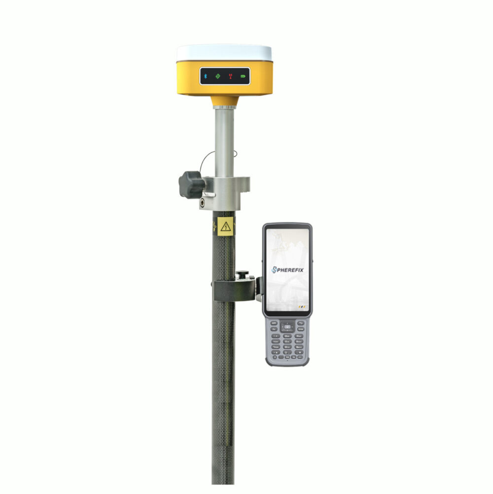




Spherefix SP10 RTK GNSS Rover Set with 60 Degree IMU
This product is available
Get the best price for your setup
Contact our experts for the best possible price and configuration.
The Spherefix SP10 RTK GNSS Rover Set is a complete, lightweight surveying solution for construction layout, land surveying, GIS data collection and accurate site measurement. The set combines the compact SP10 receiver with a Spherefix C100 data collector, surveying software, survey pole and controller bracket, giving field teams the essential equipment needed to begin network RTK measurements.
A calibration-free IMU allows the pole to be tilted by up to 60°, making it easier to measure building corners, kerbs, boundaries, slopes and points located beside obstacles. The receiver tracks GPS, GLONASS, Galileo, BeiDou and QZSS signals across 1,408 channels and uses its integrated 4G modem to receive corrections from a compatible NTRIP or CORS service. Bluetooth and Wi-Fi support communication and receiver configuration, while the internal battery provides more than 16 hours of typical rover operation.
Spherefix SP10 Rover Set Highlights
| Complete rover set | SP10 receiver, C100 controller, surveying software, pole and bracket |
|---|---|
| IMU tilt measurement | Calibration-free measurements with the pole tilted up to 60° |
| GNSS tracking | 1,408 channels with GPS, GLONASS, Galileo, BeiDou and QZSS |
| RTK corrections | Integrated 4G modem for compatible NTRIP and CORS networks |
| RTK accuracy | Horizontal ±8 mm + 1 ppm and vertical ±15 mm + 1 ppm |
| Battery endurance | More than 16 hours during typical GSM rover operation |
| Field protection | IP65 housing with resistance to a 1.5 m pole drop |

Valued customers:










Find RTK Networks
Search NTRIP providers and connect to reliable RTK correction services.
Description
Complete Network RTK Rover Set for Accurate Field Measurement
The Spherefix SP10 RTK GNSS Rover Set provides surveyors, construction professionals, engineers and GIS teams with a practical package for centimetre-level positioning. Instead of supplying only the GNSS receiver, the set combines the SP10 with a Spherefix C100 data collector, surveying software, survey pole and controller bracket. This creates a coordinated field solution for collecting points, setting out coordinates and managing survey data.
The lightweight receiver is designed for crews that move regularly around construction sites, roads, boundaries and large survey areas. At approximately 510 g, the SP10 adds less weight to the survey pole than many conventional GNSS receivers, helping reduce fatigue during long periods of stakeout or detail measurement.
Measure Difficult Points with a Tilted Survey Pole
The SP10 includes an integrated inertial measurement unit that compensates for pole angles of up to 60°. The operator can therefore measure many points without holding the pole perfectly vertical or repeatedly centring the pole bubble.
In practical fieldwork, this is useful when measuring beside walls, beneath overhangs, at building corners, along fences or close to parked machinery. It can also make measurements on banks, uneven ground and busy construction sites more convenient. The inertial system does not require a separate startup calibration routine, allowing the operator to begin tilt measurements with fewer preparation steps.
The specified tilt accuracy is less than 2 cm within the supported 60° range under suitable operating conditions. Final accuracy remains dependent on satellite visibility, correction quality, pole-height settings, multipath and the surrounding environment.
Multi-Constellation Tracking for Reliable Positioning
The receiver uses 1,408 channels to track signals from GPS, GLONASS, Galileo, BeiDou and QZSS. Using several constellations gives the receiver access to a larger number of satellites and observations, which can help maintain a usable solution across typical surveying and construction environments.
Multi-constellation tracking is particularly valuable on sites where parts of the sky are obstructed by buildings, trees or equipment. It cannot completely remove the effects of signal blockage and reflection, but it gives the positioning engine more information to work with than a receiver that supports fewer systems.
Centimetre-Level Network RTK Surveying
The Spherefix SP10 is designed primarily as a network RTK rover. Its integrated 4G modem connects to a compatible NTRIP or CORS correction service using a suitable SIM card and data connection. This allows crews to work within an established RTK network without setting up a local radio base station for every project.
The specified RTK accuracy is ±8 mm + 1 ppm horizontally and ±15 mm + 1 ppm vertically under suitable conditions. This level of performance supports common applications such as construction stakeout, topographic surveys, site control, boundary-related measurement, utility mapping and as-built recording.
The SP10 does not contain an internal UHF radio. Buyers planning to work outside mobile-network coverage or with a radio base station should confirm the required external communication equipment before selecting their configuration.
Field Controller and Surveying Software Included
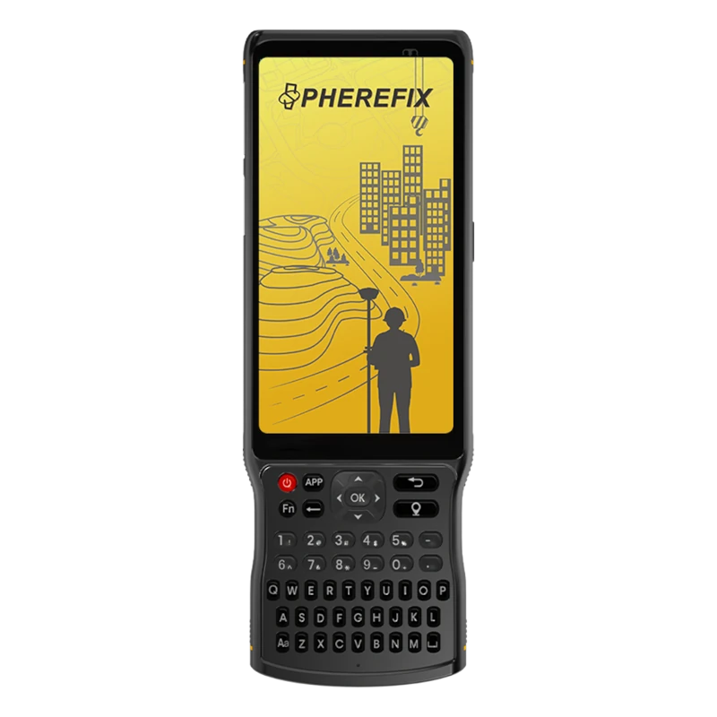
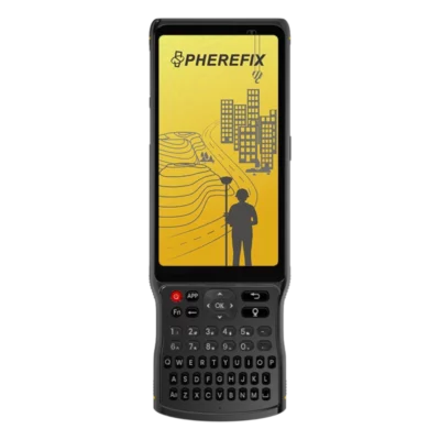
The included Spherefix C100 data collector provides the interface between the operator, the GNSS receiver and the surveying software. It can be mounted to the supplied survey pole using the controller bracket, keeping measurements, maps and stakeout information visible while working.
The surveying software supports the essential workflow around the receiver, including connecting to the GNSS equipment, configuring rover corrections, measuring points and managing coordinate data. Available field functions include topographic point collection, control-point measurement, quick measurements, automatic point collection, point databases and stakeout workflows.
For construction teams, this means design coordinates can be taken into the field and located on the ground. Surveyors can collect coded points for later processing, while GIS and utility users can record accurate asset positions and associated information.
Suitable for Construction Surveying and GIS Work
On construction projects, the set can be used to position foundations, grid lines, drainage features, kerbs, roads and other design elements. It can also support excavation checks, stockpile or surface measurements and the recording of completed work. Tilt compensation is especially useful when the required point is close to a structure or cannot be approached with a vertical pole.
Land surveyors can use the SP10 for detail surveys, control densification, coordinate stakeout and static observations. GIS teams can collect accurate locations for utilities, street furniture, environmental assets and infrastructure inspections. Drone operators may also use the rover to survey ground control and independent check points for photogrammetry projects, provided the complete control workflow meets the project’s accuracy requirements.
Long Battery Endurance for Mobile Crews
The SP10 contains a 9,600 mAh lithium battery and is specified for more than 16 hours of typical rover operation while using its mobile-network connection. This is intended to support a normal field day without stopping to replace the receiver battery.
The USB Type-C charging interface supports several compatible charging profiles. Actual working time will vary with temperature, network use, receiver settings and battery condition, so crews working remotely should still plan suitable charging or backup power.
Compact Receiver Built for Outdoor Conditions
The receiver uses a magnesium-alloy main body with an ABS and polycarbonate upper cover. Its IP65 protection rating helps protect it against dust and water jets during normal outdoor fieldwork. It is also specified to withstand a 1.5 m pole drop at room temperature.
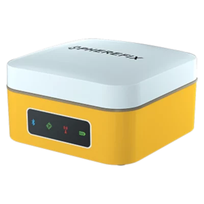
An operating-temperature range of −20°C to +60°C makes the receiver suitable for a wide range of climates. Status indicators show power, satellite positioning, Bluetooth and differential correction activity, allowing operators to check essential receiver conditions directly in the field.
Flexible Rover Set Configuration
The standard product listing combines the SP10 receiver with a C100 data collector, Spherefix surveying software, a survey pole and controller bracket. The controller, software and accessories may be adapted where a project requires a different tablet, field application or pole configuration.
Compatibility should be confirmed before changing any component. Coordinate systems, correction-network access, data formats and software licensing can all affect whether a rover set fits an existing survey workflow.
Buying the Spherefix SP10 from Global GPS Systems
Global GPS Systems can help buyers confirm the appropriate controller, surveying software, pole accessories and RTK correction service for their work. This is particularly important for users moving from standalone GPS equipment to centimetre-level network RTK, as the receiver, field software, coordinate-system settings and NTRIP account must work together correctly.
The Spherefix SP10 Rover Set is well suited to professionals looking for a lightweight and complete network RTK package with calibration-free tilt compensation, multi-constellation tracking and enough battery capacity for a full working day.
Datasheets & Manuals
Datasheets and manuals
Specifications
Spherefix SP10 Rover Set Specifications
Set Overview
| Product Type | Complete network RTK GNSS rover surveying set |
|---|---|
| Receiver Model | Spherefix SP10 |
| Data Collector | Spherefix C100 rugged Android controller |
| Primary Applications | Land surveying, construction layout, cadastral surveying, topographic surveys, stakeout, control-point measurement and GIS data collection |
| RTK Correction Method | Network RTK corrections through NTRIP/CORS services using the receiver or controller internet connection |
| Integrated UHF Radio | None |
| Supported Receiver Modes | Rover, base and static |
| Post-Processing | PPK and static raw-data recording supported |
SP10 Key Features
| GNSS Channels | 1408 |
|---|---|
| Satellite Constellations | GPS, GLONASS, BeiDou, Galileo and QZSS |
| RTK Positioning | Centimeter-level positioning |
| IMU Tilt Compensation | Calibration-free tilt measurement up to 60° |
| Tilt Accuracy | Less than 2 cm within a 60° tilt range |
| Magnetic-Field Operation | Tilt measurement can be used in the presence of magnetic fields |
| Cellular Connectivity | Integrated 4G/GSM modem |
| Wireless Connectivity | Bluetooth and Wi-Fi |
| Receiver Weight | Approximately 510 g |
| Receiver Protection | IP65 |
GNSS Signal Tracking
| Constellation | Supported Signals | Tracking Type |
|---|---|---|
| GPS | L1 C/A, L2P, L5 | Multi-frequency |
| GLONASS | L1, L2 | Dual-frequency |
| BeiDou | B1I, B2I, B3I, B1C, B2a | Multi-frequency |
| Galileo | E1, E5a, E5b | Multi-frequency |
| QZSS | L1, L2, L5 | Multi-frequency |
GNSS Engine and Data
| Receiver Processor | Qualcomm Cortex-A7 |
|---|---|
| Receiver Operating System | Linux |
| Position Data Format | NMEA 0183 |
| Correction Input/Output Protocol | RTCM 3.x |
| Maximum Data Update Rate | 5 Hz |
| Signal Recapture Time | Less than 1 second |
| Cold Start Time | Less than 40 seconds |
| Raw GNSS Data Recording | Supported |
| PPK Recording | Supported in rover and base workflows |
Positioning Accuracy
| Positioning Mode | Horizontal Accuracy | Vertical Accuracy |
|---|---|---|
| Single Point, RMS | 1.5 m | 2.5 m |
| DGPS, RMS | 0.4 m | 0.8 m |
| RTK, RMS | ±(8 mm + 1 ppm) | ±(15 mm + 1 ppm) |
| Static, RMS | ±(2.5 mm + 0.5 ppm) | ±(5 mm + 0.5 ppm) |
Additional Measurement Performance
| Time Accuracy, RMS | 10 ns |
|---|---|
| Velocity Accuracy, RMS | 0.2 m/s |
| Maximum Compensated Pole Tilt | 60° |
| Tilt Compensation Accuracy | Less than 2 cm within 60° |
| IMU Calibration | No manual calibration required before measurement |
| Pole-Tip Calculation | Compensates the surveyed pole-tip position while the pole is inclined |
Receiver Communications
| Bluetooth | Bluetooth BR, EDR and BLE |
|---|---|
| Wi-Fi Standard | IEEE 802.11 b/g/n |
| Wi-Fi Modes | Disabled, access point and station |
| Cellular Modem | Integrated LTE and GSM modem |
| LTE FDD Bands | B1, B2, B3, B5 and B8 |
| LTE TDD Bands | B38, B39, B40 and B41 |
| GSM Bands | 900 MHz and 1800 MHz |
| SIM Interface | External SIM-card slot |
| Correction Data Links | Bluetooth, Wi-Fi, built-in cellular network and XLink |
| NTRIP/CORS Support | Supported through phone internet or the receiver’s integrated cellular connection |
Receiver Storage and Data Management
| Internal Storage | 32 GB nominal |
|---|---|
| Available Recyclable Data Storage | Approximately 24 GB |
| Storage Channels | Five configurable channels: CH01, CH02, CH03, CH04 and CH05 |
| Rover Recording | Automatic raw-positioning data storage with optional PPK recording |
| Base Recording | Automatic reference-station raw-data storage with optional post-processing recording |
| Static Recording | Dedicated static observation-data storage |
| Bluetooth Diagnostic Recording | Automatic Bluetooth monitoring data can be stored for troubleshooting |
| File Management | Recorded files can be downloaded or deleted through the receiver Web UI |
| Configurable Recording Parameters | Data source, file duration, file name, file format, sampling interval, elevation cutoff and mode-dependent settings |
Receiver Interfaces and Controls
| Power Button | Battery-status check, power-on and shutdown control |
|---|---|
| Reset Button | Forces the receiver to shut down without restoring factory settings |
| Charging Port | USB Type-C |
| Web Management Interface | Browser-based receiver configuration and monitoring |
| Default Web UI Address | 10.10.10.10 while connected to the receiver Wi-Fi hotspot |
| Web UI Functions | GNSS-status monitoring, skyplot, working-mode setup, data-link setup, raw-data download, file management, firmware updates, logging and device registration |
| Remote Assistance | Supported through the receiver network connection |
Receiver Status Indicators
| Power Indicator | Shows power, battery and charging status |
|---|---|
| Satellite Indicator | Shows satellite-search and positioning status |
| Bluetooth Indicator | Shows Bluetooth connection status |
| Differential Data Indicator | Shows RTK correction-data reception status |
| Audible Status Alerts | Integrated buzzer for startup, shutdown and abnormal-status notifications |
Receiver Power
| Battery Type | Integrated rechargeable lithium battery |
|---|---|
| Battery Rating | 3.7 V, 9600 mAh |
| Typical Rover Runtime | More than 16 hours in rover mode using GSM communications |
| Static Recording Runtime | Up to 24 hours of continuous static data collection under full-power conditions |
| Typical Charging Time | Approximately 3 hours |
| Supported Charging Inputs | 5 V/3 A, 9 V/2 A and USB Power Delivery 12 V/1.25 A |
| Fast-Charging Support | MTK Pump Express 1.1/2.0 and USB Power Delivery |
| Charging Management | Adaptive dynamic charging-current control |
Receiver Environmental Specifications
| Ingress Protection | IP65 |
|---|---|
| Operating Temperature | -20°C to +60°C |
| Storage Temperature | -40°C to +85°C |
| Drop Resistance | Designed to withstand a 1.5 m survey-pole drop at room temperature |
| Main Body Material | Magnesium alloy |
| Top Cover Material | ABS/PC engineering polymer |
Receiver Physical Specifications
| Dimensions | 100.5 × 100.5 × 69 mm |
|---|---|
| Diameter | 100.5 mm |
| Height | 69 mm |
| Weight | Approximately 510 g |
| Housing Construction | Magnesium-alloy main body with ABS/PC top cover |
Spherefix C100 Data Collector
| Controller Type | Rugged Android surveying data collector with touchscreen and alphanumeric keypad |
|---|---|
| Display | 5.5-inch sunlight-readable HD touchscreen |
| Processor | 8-core 2.0 GHz CPU |
| Operating System | Android 11 |
| Memory | 3 GB RAM |
| Internal Storage | 32 GB ROM |
| Rear Camera | 13 MP |
| Cellular Connectivity | 4G mobile-data support |
| SIM Support | Dual SIM |
| Wireless Connectivity | Wi-Fi and Bluetooth |
| USB Interface | USB Type-C |
| Battery Capacity | 7700 mAh |
| Typical Battery Runtime | More than 15 hours |
| Environmental Protection | IP67-rated protection against water and dust |
| Field Durability | Ruggedized for outdoor surveying environments and shock exposure |
| Input Methods | Capacitive touchscreen and physical alphanumeric keypad |
Surveying Software and Field Functions
| Included Software | Spherefix field surveying software |
|---|---|
| Project Management | Create, import, export, open and delete survey projects |
| Coordinate-System Configuration | Supported |
| Receiver Connection | Bluetooth, port and TCP client communication options |
| Rover Configuration | Supported |
| Base Configuration | Supported |
| Static Surveying | Supported |
| Point Survey | Supported |
| Tilt Survey | Supported |
| Point Stakeout | Supported |
| Localization | Supported |
| Point Calibration | Supported |
| Point Database | Supported |
| Survey Data Export | Supported |
| CORS/NTRIP Configuration | Server profiles, mount-point selection and network RTK correction setup supported |
Package Contents
| Item | Quantity | Notes |
|---|---|---|
| Spherefix SP10 GNSS Receiver | 1 | 1408-channel network RTK rover with integrated IMU and 4G modem |
| Spherefix C100 Data Collector | 1 | Rugged Android field controller |
| Spherefix Surveying Software | 1 license | Field data collection, surveying and stakeout software |
| Survey Pole | 1 | For mounting and operating the SP10 receiver as a rover |
| Data Collector Bracket | 1 | Mounts the controller to the survey pole |
Specifications and package contents may vary by configuration, region or manufacturer update. Always check the current configuration before ordering.
FAQ
Spherefix SP10 Rover Set FAQ
Product Overview and Applications
What is the Spherefix SP10 Rover Set?
The Spherefix SP10 Rover Set is a complete RTK GNSS field surveying solution built around the compact SP10 receiver. It combines a GNSS rover, data collector, surveying software, survey pole and controller bracket for measuring and staking out points with centimetre-level positioning.
Who is the Spherefix SP10 Rover Set designed for?
The set is designed for land surveyors, construction professionals, civil engineers, GIS teams, utility contractors and mapping specialists who need accurate field coordinates and an efficient one-person surveying workflow.
What surveying tasks can the SP10 Rover Set perform?
The SP10 Rover Set can be used for topographic surveys, construction layout, point stakeout, as-built measurements, cadastral work, control-point surveys, utility mapping, terrain data collection and ground control point measurement for drone mapping.
Is the SP10 Rover Set suitable for construction work?
Yes. Construction teams can use it to stake out design coordinates, measure existing site features, verify completed work, record as-built positions and collect terrain points for roads, buildings, drainage systems and other infrastructure projects.
Can the SP10 Rover Set be used for GIS and asset mapping?
Yes. It can collect accurate coordinates for utilities, pipelines, cables, drainage assets, roads, boundaries, street furniture, environmental features and other infrastructure that must be recorded in a GIS or mapping system.
Can one person operate the SP10 Rover Set?
Yes. The lightweight receiver, wireless controller connection, surveying software and IMU tilt compensation make the set suitable for efficient one-person field surveying.
Accuracy, GNSS and IMU Tilt
Does the Spherefix SP10 provide centimetre-level accuracy?
Yes. When the receiver has a suitable RTK correction source, a clear satellite view and a fixed RTK solution, it is designed to provide centimetre-level positioning. Actual accuracy depends on correction quality, satellite geometry, environmental conditions and the selected coordinate system.
Which satellite constellations does the SP10 track?
The SP10 supports multiple GNSS constellations, including GPS, GLONASS, Galileo, BeiDou and QZSS. Tracking several constellations improves satellite availability and positioning reliability in different regions.
How many GNSS channels does the SP10 receiver have?
The Spherefix SP10 has 1,408 GNSS channels for tracking signals from multiple satellite constellations and frequencies.
What does the SP10 IMU tilt compensation do?
The integrated IMU compensates for an inclined survey pole, allowing the receiver to calculate the position of the pole tip even when the pole is not held perfectly vertical. This helps users measure points beside walls, fences, trenches, vehicles and other obstacles.
What is the maximum tilt angle supported by the SP10?
The SP10 supports pole tilt measurement at inclinations of up to 60 degrees. Positioning accuracy within the supported tilt range depends on correct pole-height settings, RTK status and field conditions.
Does the SP10 IMU require manual calibration?
The SP10 uses seamless inertial navigation and is designed to begin tilt measurement without a separate manual calibration procedure at every startup. Operators should still confirm that tilt measurement is active and initialized before recording important points.
RTK Corrections, Connectivity and Software
How does the SP10 Rover Set receive RTK corrections?
The rover can receive internet-based corrections from a compatible NTRIP or CORS network through its integrated 4G modem. The receiver must be configured with the correct server address, port, mount point and account credentials.
Does the Spherefix SP10 have an internal UHF radio?
No. The SP10 configuration in this rover set does not include an internal UHF radio. It is primarily intended for network RTK operation through a mobile internet connection. An external communication solution may be required for workflows that use a local radio base station.
Do I need an RTK network subscription to use this rover set?
An RTK correction service is required for real-time centimetre-level positioning. This may be a public or commercial NTRIP network, a compatible CORS service or another suitable correction source. Availability and access requirements vary by country and region.
Does the SP10 require a SIM card?
A compatible SIM card with an active mobile data connection is normally required when the receiver uses its integrated 4G modem to connect directly to an NTRIP or CORS correction service.
How does the SP10 connect to the data collector?
The SP10 supports Bluetooth and Wi-Fi communication for connection to a compatible data collector or controller. The field software is then used to configure the receiver, create projects, measure points and perform stakeout work.
What can I do with the included Spherefix surveying software?
The surveying software supports common field operations such as project creation, coordinate-system setup, rover configuration, point measurement, tilt surveying, stakeout, localization, point calibration, point management and data export.
Set Contents, Battery and Durability
What is included with the Spherefix SP10 Rover Set?
The standard set includes the Spherefix SP10 GNSS receiver, a Spherefix data collector, compatible surveying software, a surveying pole and a data collector bracket. The exact controller, software licence and accessory configuration should be confirmed when ordering.
Can the controller or software in the set be changed?
Yes. The rover set can be configured with alternative controllers, tablets or compatible surveying software depending on the required workflow. Compatibility and licence requirements should be checked before selecting a different configuration.
How long does the SP10 receiver battery last?
The SP10 contains a 9,600 mAh lithium battery and is specified for more than 16 hours of typical rover operation using its mobile network connection. Actual battery life varies with temperature, communication settings and field use.
How much does the Spherefix SP10 receiver weigh?
The SP10 receiver weighs approximately 510 grams, making it compact and comfortable to carry on a survey pole during extended field sessions.
Is the SP10 protected against dust and water?
Yes. The receiver has an IP65 protection rating, meaning its enclosure is dust-tight and protected against water jets. It is not designed for underwater use or prolonged submersion.
Can the SP10 withstand accidental drops?
The receiver is specified to withstand a 1.5-metre pole drop under normal test conditions. A secure pole connection, protective transport case and careful handling are still recommended.
Reviews (0)
Only logged in customers who have purchased this product may leave a review.

 GPS & GNSS
 Total Stations
 Data collectors
 Software
 Correction services
 Machine control
 External radio
 Lasers & levellers
 Marine
 Accessories
Reviews
There are no reviews yet