
 GPS & GNSS
 Lidar scanning
 Total Station


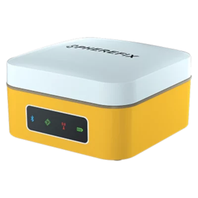
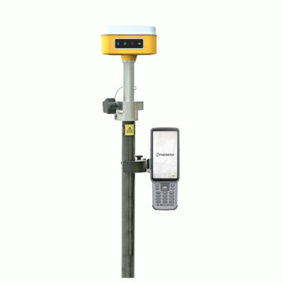
Spherefix SP10 RTK GNSS Receiver with 60 Degree IMU
This product is available
Get the best price for your setup
Contact our experts for the best possible price and configuration.
The Spherefix SP10 RTK GNSS receiver is a compact and lightweight positioning solution for land surveying, construction setting-out, GIS data collection and other centimetre-accuracy fieldwork. Its calibration-free IMU allows points to be measured with the survey pole tilted by up to 60°, helping operators reach corners, edges, slopes and other locations where holding the pole perfectly vertical is difficult.
The receiver tracks multiple GNSS constellations and uses an integrated 4G modem to receive network RTK corrections. Bluetooth and Wi-Fi provide flexible connections to a field controller, while the long-life internal battery supports a full working day in the field.
Spherefix SP10 Highlights
| IMU tilt compensation | Up to 60° without startup calibration |
|---|---|
| GNSS tracking | 1,408 channels with GPS, GLONASS, Galileo, BeiDou and QZSS |
| RTK connectivity | Integrated 4G modem for network corrections |
| Battery endurance | More than 16 hours in typical rover GSM operation |
| Field protection | IP65 housing with 1.5 m pole-drop resistance |
| Receiver weight | Approximately 510 g |

Valued customers:










Find RTK Networks
Search NTRIP providers and connect to reliable RTK correction services.
Description
Compact RTK GNSS Receiver for Everyday Fieldwork
The Spherefix SP10 is a portable RTK GNSS receiver developed for surveyors, construction teams, engineers, GIS professionals and other users who need accurate coordinates without carrying a large or heavy receiver. Its compact housing and approximately 510 g weight make it comfortable to use on a survey pole throughout the working day, particularly when crews need to move frequently between points or cover a large site.
The receiver can be used for topographic surveys, construction layout, utility mapping, site measurements, control work, asset collection and general GNSS positioning. It supports rover, base and static operating modes, allowing the same receiver platform to fit several common surveying workflows. Because the SP10 has no internal UHF radio, it is especially suitable for network RTK operation through an NTRIP or CORS correction service. Alternative base and rover configurations require a compatible external communication method.
Measure with the Pole Tilted up to 60 Degrees
The integrated IMU tilt sensor allows the SP10 to calculate a point while the survey pole is inclined by up to 60°. Operators do not need to centre the pole bubble perfectly for every observation, which can reduce the time spent positioning the pole during repetitive measurements.
Tilt compensation is particularly useful beside walls, underneath obstacles, at building corners, near fences, on embankments and in locations where the point cannot be reached safely with a vertical pole. The inertial system is designed to operate without a separate calibration routine at startup, so the receiver can be prepared for measurement with fewer steps.
Under suitable RTK conditions, the specified tilt positioning accuracy is less than 2 cm throughout the supported tilt range. Actual results still depend on correction quality, satellite visibility, multipath, the surrounding environment and correct field procedures.
Multi-Constellation GNSS Tracking
With 1,408 tracking channels, the Spherefix SP10 receives signals from GPS, GLONASS, Galileo, BeiDou and QZSS satellites. Access to several constellations and frequencies gives the receiver more satellite observations to work with, helping it maintain a usable position in many normal construction and surveying environments.
This does not remove the effects of buildings, trees, machinery or reflective surfaces, but it can improve satellite availability compared with receivers that use fewer constellations. For best results, operators should maintain a clear view of the sky and confirm that the receiver has reached the required fixed solution before recording critical points.
Integrated 4G Network RTK Connectivity
The built-in 4G modem allows the receiver to connect directly to supported online correction services using a suitable SIM card and data subscription. This makes the SP10 practical for survey crews working inside an established RTK network, because a separate radio base station may not be required.
Bluetooth can be used to communicate with a compatible field controller, while Wi-Fi provides access to the receiver interface for configuration and device management. Through the web interface, users can review GNSS status, select operating modes, manage files, adjust data output and update receiver firmware.
Long Battery Life for Full Working Days
A built-in 9,600 mAh lithium battery provides more than 16 hours of typical rover operation when using the GSM connection. This is intended to cover a normal field day without requiring a battery change. Charging is handled through the USB Type-C connection, making it easier to use commonly available charging equipment when working away from the office.
Battery endurance varies with network activity, temperature, receiver configuration and battery condition. For long projects or remote work, crews should still plan an appropriate charging or backup-power arrangement.
Designed for Outdoor Surveying Conditions
The SP10 uses a magnesium-alloy main body with an ABS and polycarbonate upper cover. Its IP65 rating protects it against dust and water jets encountered during typical outdoor use, while the stated pole-drop resistance provides additional protection against everyday field accidents.
The receiver is specified for operation from −20°C to +60°C. Its status panel gives the operator a quick view of power, satellite positioning, Bluetooth and differential correction activity without needing to open the field software for every check.
Suitable Applications
For construction teams, the Spherefix SP10 can support point layout, level and position checks, site control, earthwork measurements and as-built recording. Surveyors can use it for detail surveys, stakeout, control densification and static data collection. GIS and utility teams can record accurate assets, inspection points and infrastructure locations using compatible field software and coordinate systems.
The lightweight design is also useful for professionals who regularly transport their equipment between vehicles, sites and remote measurement areas. Drone operators may use accurately surveyed ground control or check points as part of a photogrammetry workflow, provided the complete survey method meets the accuracy requirements of the project.
Buying and Support from Global GPS Systems
Choosing an RTK receiver involves more than comparing the receiver specification alone. Correction-service access, field-controller compatibility, survey software, coordinate-system setup and local workflows all affect how the equipment performs in practice. Global GPS Systems can help buyers select a suitable SP10 configuration and match it with compatible controllers, software and network RTK services.
The Spherefix SP10 is a practical choice for users who want a lightweight network RTK receiver with multi-constellation tracking, calibration-free tilt measurement and enough battery capacity for a full day of positioning work.
Datasheets & Manuals
Datasheets and manuals
Specifications
Spherefix SP10 GNSS Receiver Specifications
Product Overview
| Product Type | Portable multi-constellation, multi-frequency GNSS RTK receiver |
|---|---|
| Primary Applications | Land surveying, construction layout, topographic surveying, cadastral work, control-point collection, GIS data capture and stakeout |
| Supported Operating Modes | RTK rover, RTK base, network RTK, static surveying and PPK data collection |
| Processor | ARM Cortex-A7 |
| Operating System | Linux intelligent system |
| Positioning Capability | Centimeter-level positioning with RTK corrections |
GNSS Tracking
| Constellation | Supported Signals | Notes |
|---|---|---|
| GPS | L1 C/A, L2P, L5 | Multi-frequency tracking |
| GLONASS | L1, L2 | Dual-frequency tracking |
| BeiDou | B1I, B2I, B3I, B1C, B2a, B2b | Multi-frequency BDS tracking |
| Galileo | E1, E5a, E5b, E6 | Multi-frequency tracking |
| QZSS | L1, L2, L5 | Regional augmentation and positioning support |
GNSS Engine and Data
| GNSS Channels | 1408 channels |
|---|---|
| Position Data Format | NMEA 0183 |
| Correction Protocol | RTCM 3.x |
| Maximum Data Update Rate | 5 Hz |
| Signal Recapture Time | Less than 1 second |
| Cold Start Time | Less than 40 seconds |
| Raw Observation Recording | Supported for static surveying and post-processing workflows |
| PPK Support | Supported |
Positioning Accuracy
| Positioning Mode | Horizontal Accuracy | Vertical Accuracy |
|---|---|---|
| Single Point, RMS | 1.5 m | 2.5 m |
| DGPS, RMS | 0.4 m | 0.8 m |
| RTK, RMS | ±(8 mm + 1 ppm) | ±(15 mm + 1 ppm) |
| Static, RMS | ±(2.5 mm + 1 ppm) | ±(5 mm + 1 ppm) |
Additional Measurement Performance
| Time Accuracy, RMS | 20 ns |
|---|---|
| Velocity Accuracy, RMS | 0.03 m/s |
| Tilt Compensation Accuracy | Less than 2 cm within a pole tilt range of up to 60° |
| Maximum Compensated Pole Tilt | 60° |
IMU Tilt Compensation
| Tilt Sensor | Integrated inertial measurement system |
|---|---|
| Calibration Requirement | Calibration-free operation; designed to be ready for tilt measurement after startup and initialization |
| Magnetic Interference | Designed to operate without reliance on a magnetic compass, allowing use around magnetic fields |
| Measurement Function | Calculates the position of the survey-pole tip while the pole is inclined |
| Typical Uses | Building corners, fence lines, slopes, obstructed points and other locations where vertical pole placement is difficult |
Communications
| Bluetooth | Bluetooth BR, EDR and BLE |
|---|---|
| Wi-Fi | IEEE 802.11 b/g/n |
| Wi-Fi Modes | Disabled, access point and station modes |
| Cellular Modem | Integrated 4G LTE/GSM modem |
| LTE FDD Bands | B1, B2, B3, B5 and B8 |
| LTE TDD Bands | B38, B39, B40 and B41 |
| GSM Bands | 900 MHz and 1800 MHz |
| SIM Card | External SIM-card slot for integrated mobile-network communications |
| Supported Data Links | Bluetooth, Wi-Fi, built-in cellular network and XLink |
| Network Corrections | Supports CORS/NTRIP-based correction workflows through a controller or the receiver’s integrated network connection |
Internal Storage and Data Management
| Internal Storage | 32 GB nominal |
|---|---|
| Documented Data Storage Area | Approximately 24 GB recyclable storage, depending on firmware and system allocation |
| Recording Channels | Five configurable data channels: CH01, CH02, CH03, CH04 and CH05 |
| Rover Data Recording | Automatic raw positioning-data storage; optional PPK data recording |
| Base Data Recording | Automatic base-station raw-data storage; optional post-processing data recording |
| Static Data Recording | Dedicated static observation-data storage |
| File Management | Recorded files can be viewed, downloaded or deleted through the receiver Web UI |
| Configurable Recording Parameters | Data source, file period, file name, file format, sampling interval, elevation cutoff and other mode-dependent settings |
Receiver Interfaces and Controls
| Power Control | Multifunction power button for battery check, power-on and shutdown |
|---|---|
| Reset Control | Dedicated forced-shutdown reset button |
| Charging Interface | USB Type-C |
| Configuration Interface | Browser-based Web UI and Spherefix field software |
| Web UI Address | 10.10.10.10 when connected to the receiver’s Wi-Fi hotspot |
| Web UI Functions | GNSS status monitoring, satellite skyplot, operating-mode setup, data-link configuration, firmware updates, raw-data download, file management, logging and device registration |
| Remote Support | Remote-assistance capability through the receiver’s network connection |
Status Indicators
| Power Indicator | Displays operating, battery and charging status |
|---|---|
| Satellite Indicator | Displays satellite-search and positioning status |
| Bluetooth Indicator | Displays Bluetooth connection status |
| Data-Link Indicator | Displays differential-correction data status |
| Audible Alerts | Integrated buzzer for startup, shutdown and abnormal-status notifications |
Power and Charging
| Battery Type | Integrated rechargeable lithium battery |
|---|---|
| Battery Rating | 3.7 V, 9600 mAh |
| Typical Rover Runtime | More than 16 hours in rover mode using GSM communications |
| Static Recording Runtime | Up to 24 hours of continuous static data collection under full-power conditions |
| Charging Time | Approximately 3 hours with a compatible charger |
| Supported Charging Inputs | 5 V/3 A, 9 V/2 A and USB Power Delivery 12 V/1.25 A |
| Fast-Charging Support | MTK Pump Express 1.1/2.0 and USB Power Delivery |
| Charging Management | Adaptive dynamic charging-current control |
Environmental and Durability
| Ingress Protection | IP65 |
|---|---|
| Operating Temperature | -20°C to +60°C |
| Storage Temperature | -20°C to +85°C |
| Drop Resistance | Designed to withstand a 1.5 m pole drop at room temperature |
| Housing Construction | Magnesium-alloy main body with ABS/PC top cover |
| Field Protection | Protected against dust and water jets in accordance with its IP65 rating |
Physical Specifications
| Dimensions | 100.5 × 100.5 × 69 mm |
|---|---|
| Diameter | 100.5 mm |
| Height | 69 mm |
| Weight | Approximately 510 g |
| Main Body Material | Magnesium alloy |
| Top Cover Material | ABS/PC engineering polymer |
Surveying and Software Functions
| Project Management | Project creation, import, export, deletion and coordinate-system configuration through Spherefix field software |
|---|---|
| Point Survey | Supported |
| Tilt Survey | Supported |
| Point Stakeout | Supported |
| Localization | Supported |
| Point Calibration | Supported |
| Point Database | Supported |
| Data Export | Supported through Spherefix field software |
| Firmware Updating | Local firmware upgrade through the Web UI |
Specifications and package contents may vary by configuration, region or manufacturer update. Always check the current configuration before ordering.
FAQ
Spherefix SP10 GNSS Receiver FAQ
Product Overview and Applications
What is the Spherefix SP10 GNSS Receiver?
The Spherefix SP10 is a compact, portable RTK GNSS receiver designed for high-precision field data collection. It combines multi-constellation satellite tracking, IMU tilt measurement, 4G connectivity and wireless communication in a lightweight receiver.
Who is the SP10 GNSS Receiver designed for?
The SP10 is intended for surveyors, mapping professionals, civil engineers, construction teams, GIS field crews and other users who need accurate positioning and efficient point collection in the field.
What surveying tasks can the SP10 be used for?
The SP10 can support topographic surveys, cadastral surveys, control-point work, construction layout, stakeout, as-built measurements, GIS data collection and general RTK positioning workflows.
Can the SP10 be used for construction surveying?
Yes. The SP10 can be used for construction layout, checking coordinates, collecting as-built positions and staking out design points when it is configured with suitable field software and an RTK correction source.
Can the SP10 be used for GIS and asset mapping?
Yes. Its portable design and high-precision positioning capabilities make it suitable for collecting the locations of utilities, infrastructure, boundaries, environmental features and other mapped assets.
Is the SP10 suitable for one-person field surveys?
Yes. The lightweight receiver, wireless connectivity and tilt-measurement function are designed to help a single operator collect points efficiently with a survey pole and compatible controller.
GNSS, RTK and Tilt Measurement
Which satellite constellations does the SP10 support?
The SP10 supports GPS, GLONASS, BeiDou, Galileo, QZSS and SBAS satellite systems. Multi-constellation tracking can improve satellite availability across different operating regions and field conditions.
How many GNSS channels does the SP10 have?
The SP10 provides 1,408 GNSS channels for tracking signals from multiple supported satellite constellations.
What is the maximum data update rate of the SP10?
The SP10 supports a maximum GNSS data update frequency of 5 Hz.
Does the SP10 support RTK positioning?
Yes. The SP10 is an RTK receiver and can use correction data to obtain a fixed positioning solution. The achievable result depends on the correction source, satellite visibility, communication link, configuration and local field conditions.
What correction source can be used with the SP10?
The SP10 can receive network-based correction data through its mobile connectivity when configured with a suitable CORS or NTRIP service. The required access details normally include the server address, port, mount point and account credentials.
What is the SP10 tilt-measurement range?
The integrated IMU allows points to be measured with the survey pole tilted by up to 60 degrees. This helps users collect points that are difficult to reach while keeping the pole tip on the required location.
Does the survey pole need to be perfectly vertical?
Not when the IMU tilt function is active and operating correctly. The SP10 can compensate for pole inclination up to 60 degrees, allowing the operator to measure without holding the pole perfectly vertical.
Does the SP10 IMU require manual calibration at startup?
The SP10 uses seamless inertial-navigation technology and is designed to be ready for tilt measurement without a separate manual calibration routine at every startup. Users should still confirm that the IMU is initialized and ready in the field software before collecting critical points.
Can the tilt function work near magnetic interference?
The SP10 is designed to support inclined measurements in challenging environments, including locations where magnetic fields are present. Measurement quality should still be checked whenever nearby equipment or structures may affect field conditions.
Connectivity, Software and Field Setup
What communication options are available on the SP10?
The SP10 supports Bluetooth, Wi-Fi and network communication, providing several ways to connect the receiver to field controllers, software and correction services.
Does the SP10 have an integrated 4G modem?
Yes. The SP10 includes a GSM 4G modem for mobile network communication, allowing it to connect to compatible internet-based RTK correction services where suitable network coverage and service access are available.
Does the SP10 require a SIM card for network RTK?
A compatible SIM card and active mobile data service are generally required when the receiver itself is used to connect to a CORS or NTRIP correction network through its integrated 4G modem.
Can the SP10 connect to a data controller?
Yes. The SP10 can connect wirelessly to a compatible field controller through Bluetooth or Wi-Fi. Spherefix offers data-controller options, but compatibility should be confirmed for the chosen controller and survey software.
What software can be used with the SP10?
The receiver can be used with compatible GNSS field-survey software for project setup, coordinate-system configuration, point collection, stakeout and data import or export. Spherefix and FieldGenius software are listed within the Spherefix product ecosystem.
What should I check if the SP10 cannot obtain an RTK fixed solution?
Check that the receiver has a clear view of the sky, sufficient satellite tracking, valid correction-service credentials and an active communication link. Also confirm that the NTRIP or CORS settings are correct and that the correction data is being received.
What should I check if the SP10 cannot connect through Bluetooth?
Confirm that the receiver is powered on, Bluetooth and location permissions are enabled on the controller, and the devices are within range. Search for the receiver again and complete Bluetooth pairing if it is the first connection.
Battery, Durability and Physical Specifications
How much does the SP10 GNSS Receiver weigh?
The SP10 weighs approximately 510 grams, making it a lightweight receiver for extended field use and transportation between survey sites.
What are the dimensions of the SP10?
The receiver measures approximately 100.5 × 100.5 × 69 millimetres.
How long does the SP10 battery last?
The SP10 is specified to provide more than 16 hours of working time from its 3.7-volt, 9,600 mAh battery. Actual operating time can vary with network use, wireless connections, temperature and receiver settings.
What is the operating temperature range of the SP10?
The specified operating temperature range is from -20°C to +60°C, allowing the receiver to be used across a wide range of normal field environments.
What environmental protection rating does the SP10 have?
The SP10 has an IP65 protection rating. This means its enclosure is dust-tight and protected against water jets, but the receiver should not be submerged in water.
Can the SP10 withstand accidental drops?
The SP10 is specified to withstand a 1.5-metre pole drop. Proper handling, secure pole mounting and protective transport are still recommended to reduce the risk of damage.
Reviews (0)
Only logged in customers who have purchased this product may leave a review.

 GPS & GNSS
 Total Stations
 Data collectors
 Software
 Correction services
 Machine control
 External radio
 Lasers & levellers
 Marine
 Accessories
Reviews
There are no reviews yet