


 GPS & GNSS
 Lidar scanning
 Total Station
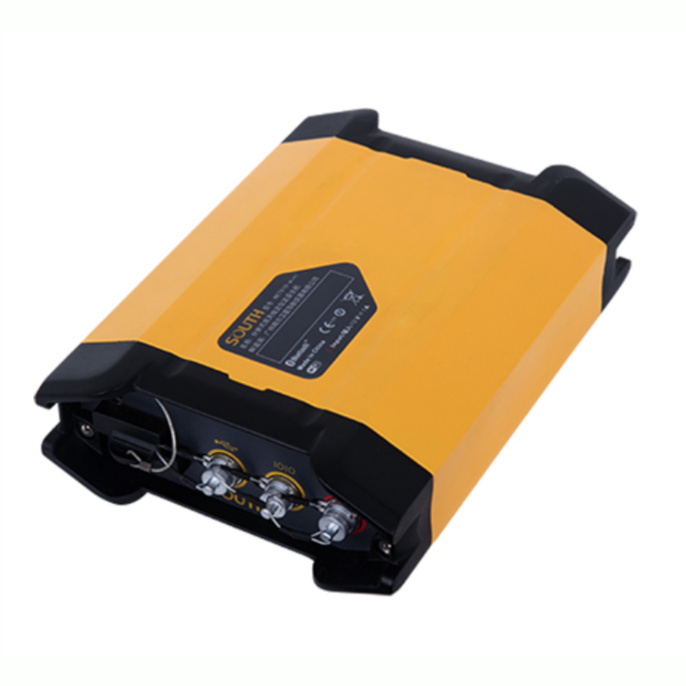
South NET S10 Mini Multi Constellation GNSS CORS Receiver
Get the best price for your setup
Contact our experts for the best possible price and configuration.
- Fast response
- Expert configuration advice
- No overpaying for features you do not need
The South NET S10 Mini is a compact GNSS CORS and reference-station receiver for continuous positioning, RTK correction delivery, and monitoring workflows. It tracks GPS, GLONASS, Galileo, BeiDou, and SBAS signals, helping surveyors and network operators maintain dependable satellite coverage. Ethernet, Wi-Fi, Bluetooth, 4G, NTRIP, and UHF support make it suitable for permanent or temporary reference installations. The Linux-based web interface allows configuration, firmware updates, data transmission, and status management from a phone, tablet, or laptop. With STH and RINEX 2.x/3.x support, configurable sampling intervals, dual-antenna capability, IP68 protection, and low power consumption, the S10 Mini fits surveying, construction control, GIS, drone mapping, infrastructure monitoring, and geodetic reference networks.
South NET S10 Mini Highlights
| GNSS Tracking | GPS, GLONASS, Galileo, BeiDou and SBAS; 1,598 channels |
|---|---|
| Positioning Accuracy | RTK: ±8 mm + 1 ppm horizontal, ±15 mm + 1 ppm vertical |
| Data Formats | STH, RINEX 2.x and RINEX 3.x |
| Connectivity | Ethernet, Wi-Fi, Bluetooth, 4G, NTRIP and UHF radio |
| Protection and Size | IP68; 184 × 134 × 54 mm; 1.2 kg |
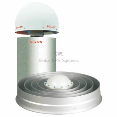
Valued customers:










Find RTK Networks
Search NTRIP providers and connect to reliable RTK correction services.
Description
South NET S10 Mini for CORS and GNSS Monitoring
The South NET S10 Mini is a compact, professional GNSS reference receiver designed for continuous operation in CORS networks, surveying infrastructure, deformation monitoring, construction control, and other applications where dependable positioning data must be collected and transmitted over long periods. It combines multi-constellation, multi-frequency satellite tracking with Linux-based processing, flexible communications, internal data storage, and remote web-based configuration in a rugged enclosure that can be installed at a permanent reference station or monitoring location.
Unlike a standard handheld GNSS rover, the S10 Mini is primarily used as the reference or base component of a positioning system. It can observe satellite signals from a fixed, accurately surveyed location and provide correction data or raw observation files to rovers, survey controllers, machine-control systems, monitoring software, and other connected users. This makes it useful for organizations that need a reliable GNSS data source rather than a portable pole-mounted receiver.
Multi-constellation tracking for dependable reference data
The receiver tracks GPS, GLONASS, Galileo, BeiDou, and SBAS signals across multiple frequency bands. Its 1,598-channel GNSS engine is designed to observe a broad range of available signals, helping maintain satellite availability when working near buildings, infrastructure, trees, or other sources of partial obstruction. Tracking several constellations also gives a reference station more usable observations for network corrections, static processing, and monitoring workflows.
For practical fieldwork, this means the S10 Mini can continue collecting useful GNSS data during changing satellite conditions instead of relying on a single constellation. Survey companies can use the receiver as part of a permanent reference station, while infrastructure and geotechnical teams can use it to support long-term monitoring of bridges, slopes, dams, roads, rail corridors, towers, and other assets. The actual result still depends on antenna quality, installation, sky visibility, correction service design, multipath conditions, atmospheric conditions, and the software used to process the data.
Designed for CORS networks and permanent installations
The South NET S10 Mini is well suited to CORS and reference-station deployments where the receiver needs to operate continuously and deliver data to multiple services. It supports TCP/IP, HTTP, and NTRIP communication, allowing it to work with network correction systems and common internet-based data workflows. The 10/100M Ethernet interface supports up to five independent data streams, which can be useful when one receiver needs to provide different outputs to surveyors, monitoring software, data centres, or correction service users at the same time.
The receiver also supports differential formats such as RTCM 2.x, RTCM 3.x, CMR, CMR+, and sCMRx, along with ASCII NMEA and binary output. This gives system integrators and survey managers more flexibility when connecting the S10 Mini to compatible field software, reference-station platforms, control centres, and third-party GNSS equipment. Compatibility with established correction formats is especially important when a network needs to serve users working with different brands of rovers or machine-control systems.
Flexible communication options for different sites
Permanent reference stations do not all have the same connectivity. Some sites have wired internet, while others depend on cellular service, Wi-Fi, radio, or a combination of communication methods. The S10 Mini includes an integrated network module and supports 4G cellular communication, 2.4 GHz Wi-Fi, Bluetooth, and optional UHF radio communication in the 410–470 MHz range. This allows the receiver to be configured for the communication method that best suits the installation.
Ethernet can be used where a stable wired connection is available. The built-in cellular connection can help support remote sites without a conventional network connection, subject to local coverage and SIM-card requirements. Wi-Fi can be used for local access, hotspot operation, or configuration, while Bluetooth provides a short-range wireless connection for compatible devices. UHF communication may be useful in base-and-rover arrangements where local radio corrections are preferred over internet-based corrections, although the final range depends on terrain, antenna setup, local regulations, radio configuration, and environmental conditions.
Remote web interface for easier setup and maintenance
The Linux operating system and integrated web interface allow users to configure and manage the receiver through a phone, tablet, laptop, or other network-connected device. A wired Ethernet connection or Wi-Fi connection can be used to access the web interface, reducing the need to connect a dedicated control panel directly to the receiver during every setup or maintenance task.
Through the web interface, users can manage receiver settings, communication parameters, data transmission, registration, firmware updates, and other operating functions. Remote access can be particularly useful for CORS operators and monitoring teams responsible for equipment installed on rooftops, observation pillars, remote structures, construction sites, or other locations where frequent visits are inconvenient. Proper network security and access controls should always be used when connecting a reference receiver to the internet.
Supports raw observation recording and standard survey formats
The S10 Mini includes internal storage for recording GNSS observation data. The standard configuration provides 8 GB of industrial storage, with higher-capacity options available up to 64 GB. Recorded data can be retrieved through HTTP, FTP push, or the USB interface, giving users several ways to move files into processing, archive, or monitoring systems.
The receiver supports STH, RINEX 2.x, and RINEX 3.x static data formats, with a customizable sampling interval. In practical use, this allows surveyors and GNSS managers to select an observation interval that matches the project. Higher-rate data may be appropriate for certain monitoring or rapid-dynamics applications, while longer intervals can reduce file size for routine reference-station logging. RINEX support also makes it easier to use the recorded observations with compatible post-processing software and services.
Dual-antenna capability for specialized workflows
A dual-antenna configuration is supported for projects that require more than a single GNSS antenna input. This can provide additional flexibility for specialized monitoring, orientation, timing, or reference-system installations. The receiver includes separate GNSS antenna connections, along with interfaces for communication, power, USB, PPS timing, and external event input.
For engineers and system integrators, these connections make the S10 Mini suitable for more advanced installations where GNSS data must be combined with external timing or event information. An external event input can be useful when coordinating GNSS observations with project-specific equipment, while PPS timing can support applications that require a precise timing reference. The exact wiring and configuration should be planned around the connected equipment and the requirements of the monitoring or reference-station software.
RTK and static accuracy for professional positioning workflows
When used in a suitable RTK setup with reliable corrections, the S10 Mini is rated for horizontal RTK accuracy of approximately ±8 mm + 1 ppm and vertical RTK accuracy of approximately ±15 mm + 1 ppm. Its stated static accuracy is approximately ±2.5 mm + 1 ppm horizontally and ±5 mm + 1 ppm vertically. These figures describe the receiver’s expected positioning capability under suitable conditions; they are not a guarantee of identical results on every site.
In field terms, the receiver can provide the high-quality reference observations needed to support centimeter-level RTK workflows when paired with a suitable rover, antenna, correction link, coordinate system, and properly established reference point. Surveyors may use it to support topographic surveys, construction layout, site control, as-built work, and infrastructure mapping. Drone mapping teams may also use reference data from a compatible S10 Mini setup to support RTK or PPK aerial workflows, provided the drone, correction service, antenna installation, coordinate reference system, and processing software are configured correctly.
Rugged construction for demanding environments
The receiver has an IP68-rated enclosure for protection against dust and water ingress. It is designed to withstand a 1.2-metre drop and is specified for operation from -40°C to 75°C, with a storage temperature range from -40°C to 85°C. The compact housing measures approximately 184 × 134 × 54 mm and weighs about 1.2 kg.
These characteristics make the S10 Mini practical for permanent and semi-permanent installations in demanding environments, including construction compounds, infrastructure corridors, industrial sites, monitoring structures, and outdoor reference-station cabinets. Even with a rugged enclosure, installation quality remains important. The GNSS antenna should have a clear view of the sky, the mounting structure should be stable, cables should be protected, and power and communications should be planned for the local environment.
Where the South NET S10 Mini can be used
The S10 Mini is intended for professional users who need a reliable GNSS reference source, monitoring receiver, or network-connected base station. Typical applications include CORS networks, local RTK correction services, construction surveying, land surveying, engineering surveys, deformation monitoring, bridge and road monitoring, slope and landslide observation, dam and reservoir monitoring, tower and structure monitoring, GIS data collection support, and aerial mapping reference workflows.
For construction companies, the receiver can form part of a site-wide positioning system that supports machine control, site surveying, checking, and layout work. For surveyors, it can provide a stable reference source for RTK and static observations. For GIS teams, it can support accurate data collection where a network correction service is required. For drone pilots and mapping professionals, it may provide a fixed reference station or correction-data source for compatible RTK and PPK operations. Monitoring specialists can use the receiver as part of a larger system that combines GNSS observations with sensors, software, alarms, and remote reporting.
Key advantages for professional users
- Tracks GPS, GLONASS, Galileo, BeiDou, and SBAS signals with a high-capacity multi-frequency GNSS engine.
- Supports Ethernet, 4G, Wi-Fi, Bluetooth, NTRIP, TCP/IP, HTTP, and optional UHF communication.
- Provides five independent data streams for connecting multiple correction or monitoring services.
- Records STH and RINEX 2.x or RINEX 3.x data with adjustable sampling intervals.
- Offers web-based configuration through a phone, tablet, laptop, or network-connected computer.
- Uses a rugged IP68 enclosure suitable for permanent reference and monitoring installations.
A practical choice for connected GNSS infrastructure
The South NET S10 Mini is best understood as a compact GNSS infrastructure receiver rather than a general-purpose handheld GPS device. Its value comes from combining accurate multi-constellation observation with flexible data output, remote management, internal recording, and several communication options. This makes it suitable for businesses and technical teams that need a dependable reference receiver that can connect to existing survey, correction, monitoring, or GIS workflows.
Before selecting a configuration, consider the required antenna, mounting method, correction format, communication method, power arrangement, cellular coverage, radio requirements, storage capacity, coordinate system, and software compatibility. A correct installation and suitable external antenna are essential to achieving the best performance from any permanent GNSS receiver.
Buy the South NET S10 Mini from Global GPS Systems
Global GPS Systems can help surveyors, engineers, construction professionals, GIS users, drone mapping teams, and monitoring specialists choose a suitable South NET S10 Mini configuration for their project. Our product specialists can help review the intended application, communication setup, antenna requirements, correction workflow, and compatibility with existing GNSS equipment before purchase. This is especially useful when the receiver will be installed as part of a CORS network, remote monitoring system, local RTK service, or professional surveying infrastructure.
Contact Global GPS Systems for configuration guidance and support with selecting the equipment needed for your GNSS reference-station or monitoring workflow.
Specifications
S10 Mini Specifications
Product Overview
| Brand | SOUTH |
|---|---|
| Model | NET S10 Mini |
| Product type | Multi-constellation GNSS CORS, reference station and monitoring receiver |
| Primary function | Continuous GNSS observation, reference station operation, correction data transmission, static data recording and high-precision monitoring |
| Operating system | Embedded Linux |
| Receiver architecture | Multi-band, multi-constellation GNSS receiver with integrated network communication functions |
| Configuration | Single- or dual-antenna configuration support |
| Intended users | Surveyors, geospatial professionals, GNSS network operators, infrastructure monitoring teams, engineering firms, utilities and scientific or industrial monitoring organizations |
GNSS Tracking
| Satellite tracking | All-in-view constellation tracking |
|---|---|
| Supported GNSS systems | GPS, GLONASS, Galileo, BeiDou and SBAS |
| GPS signals | L1 C/A, L2E, L2C and L5 |
| GLONASS signals | L1 C/A, L2P, L2C/A and L2P |
| Galileo signals | E1, E5A, E5B, B5 AltBOC and E6 |
| BeiDou signals | B1, B2 and B3 |
| SBAS support | WAAS, MSAS, EGNOS and GAGAN |
| Channel configuration | Published documentation identifies a 1,598-channel configuration, with other regional or hardware variants also listed at 336 or 440 channels. Confirm the installed GNSS board before ordering. |
| Future signal support | Designed to support current and future GNSS signals subject to receiver firmware and installed hardware configuration |
| Low-elevation tracking | Supports advanced low-elevation satellite tracking for challenging observation environments |
| Carrier-phase measurement | Low-noise GNSS carrier-phase measurement; manufacturer documentation specifies accuracy below 1 mm in a 1 Hz bandwidth |
Positioning Performance
| Positioning mode | Horizontal accuracy | Vertical accuracy |
|---|---|---|
| SBAS positioning | Typically less than 5 m, 3DRMS | Typically less than 5 m, 3DRMS |
| Autonomous positioning | Approximately ±3 m at 1 sigma with PDOP ≤ 3 | Approximately ±5 m at 1 sigma with PDOP ≤ 3 |
| Code differential | ±0.25 m + 1 ppm | ±0.50 m + 1 ppm |
| Real-time kinematic | ±8 mm + 1 ppm | ±15 mm + 1 ppm |
| Static positioning | ±2.5 mm + 1 ppm | ±5 mm + 1 ppm |
| Static positioning, alternate published specification | ±2.5 mm + 0.5 ppm | ±5 mm + 0.5 ppm |
| Initialization time | Less than 10 seconds under suitable satellite and correction conditions | |
| Reliability | Published as greater than 99%; some manufacturer documentation lists greater than 99.9% | |
Data Recording and Storage
| Internal storage | 8 GB SSD or high-speed internal memory |
|---|---|
| Optional storage | 64 GB option listed in published documentation |
| External storage | Supports external USB storage; some manufacturer documentation describes support for larger removable storage configurations |
| Position update rates | 1 Hz, 2 Hz, 5 Hz, 10 Hz and 20 Hz |
| Optional update rate | 50 Hz, depending on receiver configuration |
| Static data formats | STH, RINEX 2.x and RINEX 3.x |
| Sampling intervals | Customizable sampling interval; published options include 1, 5, 10, 15 and 30 seconds |
| Storage management | Supports cycling or loop storage and configurable independent data recording streams |
| Data retrieval | HTTP download, FTP download or push, and USB transfer |
| Recorded data types | Raw GNSS observations, static observations, navigation data and differential correction data |
Correction and Data Output
| Differential correction formats | RTCM 2.x, RTCM 3.x, CMR, CMR+, sCMRx, RTCA and NOVATELX |
|---|---|
| Navigation output | ASCII NMEA-0183 and binary output |
| NMEA messages | Published documentation lists GSV, AVR, RMC, HDT, VGK, VHD, ROT, GGK, GGA, GSA, ZDA, VTG, GST, PJT, PJK, BPQ, GLL, GRS and GBS messages |
| Proprietary output | SIC and OpenSIC data streams are listed in manufacturer documentation |
| Independent data streams | Up to five independent data streams through the Ethernet interface |
| Output interval control | Configurable output and transmission intervals |
| Data transmission security | Supports encrypted data-stream transmission according to the configured system and software environment |
Communication and Networking
| Ethernet | 10/100 Mbps Ethernet interface |
|---|---|
| Ethernet connector | RJ45 |
| Network protocols | TCP/IP, HTTP, FTP and NTRIP |
| Network operating modes | Server, client and caster modes are listed for Ethernet data services |
| NTRIP support | Supports NTRIP-based correction data transmission and reception |
| Cellular communication | Integrated 4G cellular module |
| SIM interface | Integrated SIM card slot |
| Wi-Fi | 2.4 GHz IEEE 802.11b/g/n |
| Wi-Fi operating modes | Hotspot and client modes |
| Bluetooth | Bluetooth 2.1 + EDR |
| UHF radio | 410 MHz–470 MHz radio interface |
| UHF transmission range | Up to approximately 8 km is listed in manufacturer documentation; actual range depends on antenna, terrain, interference and radio configuration |
Interfaces and I/O
| GNSS antenna connectors | Two GNSS antenna interfaces for dual-antenna configurations; the second interface may be reserved depending on configuration |
|---|---|
| UHF antenna connector | One UHF radio antenna interface |
| Cellular antenna connector | One GSM or cellular antenna interface |
| Network interface | One RJ45 Ethernet port |
| Serial interface | Serial communication port for navigation, observation, correction and timing data |
| USB interface | External USB port for data transfer and external storage functions |
| PPS interface | PPS output with UTC timing support |
| External event input | External event input for event marking and monitoring applications |
| Power interfaces | Multiple independent power input interfaces are listed in manufacturer documentation |
| LEMO interface functions | Navigation data, static data, differential correction data and PPS-UTC timing transmission |
Web Interface and Software
| User interface | Web-based interface |
|---|---|
| Web interface access | Wi-Fi, local network cable or WAN connection |
| Compatible control devices | Smartphones, tablets, laptops and desktop computers with a compatible web browser |
| Configuration functions | Receiver registration, station coordinates, antenna settings, satellite tracking, network settings, Wi-Fi settings, radio settings and system controls |
| Monitoring functions | System information, receiver status, positioning information and current satellite tracking status |
| Data functions | Static data recording, sampling configuration, data download, data transmission and track management |
| Maintenance functions | Firmware updates, module updates and remote receiver restart |
| NRS software compatibility | Designed for integration with SOUTH NRS Network Reference System software |
| Deep-NRS functions | Enhanced NRS workflow with automatic rover operating-mode selection and support for network correction services |
| Network correction technologies | NRS supports functions associated with VRS and includes selected FKP and MAX capabilities |
| Third-party compatibility | Manufacturer documentation lists compatibility with reference data from major brands including Trimble and Leica |
Power Requirements
| Input voltage | 9–36 V DC |
|---|---|
| Typical power consumption | Approximately 4.6 W |
| Power design | Ultra-low-power design with multiple independent power inputs for improved supply reliability |
| Internal battery | No internal field battery is specified in the reviewed product documentation |
Physical and Environmental Specifications
| Dimensions | 184 × 134 × 54 mm |
|---|---|
| Weight | Approximately 1.2 kg |
| Housing | Compact industrial housing with aluminum-alloy construction listed in manufacturer documentation |
| Ingress protection | IP68 water- and dust-resistant protection |
| Shock and drop resistance | Drop resistance up to 1.2 m |
| Operating temperature | Published datasheet range: −40°C to +75°C. Another manufacturer specification lists −40°C to +85°C; confirm the exact hardware revision before ordering. |
| Storage temperature | −40°C to +85°C |
| Humidity | Up to 100% relative humidity is listed in published documentation |
Typical Applications and Industries
| Surveying and mapping | Reference station networks, GNSS base stations, high-precision control surveys and geospatial data collection |
|---|---|
| Deformation monitoring | Long-term displacement monitoring, structural movement detection and automated GNSS monitoring networks |
| Geological hazard monitoring | Landslide, ground deformation and geological risk monitoring |
| Infrastructure monitoring | Bridges, dams, reservoirs, roads, railways, slopes and other civil infrastructure |
| Mining and tailings management | Tailings dam monitoring, mine-site deformation analysis and geotechnical observation |
| Utilities and energy | Power-line tower monitoring, utility infrastructure inspection and networked positioning services |
| CORS network operation | Continuous reference station networks that distribute GNSS correction data to rovers and field users |
| Engineering and construction | Site control, machine or structure monitoring, construction surveying and precision positioning support |
| Scientific and environmental monitoring | Long-duration GNSS observation, research networks and environmental or geodynamic monitoring |
Package and Included Items
| Item | Quantity | Notes |
|---|---|---|
| NET S10 Mini receiver | Configuration-dependent | Receiver supplied according to the selected GNSS board and communication configuration |
| GNSS antennas | Configuration-dependent | Single- or dual-antenna operation is supported; antennas and cables should be confirmed with the supplier |
| Cellular, UHF or Wi-Fi accessories | Configuration-dependent | Availability depends on the selected communication modules and deployment requirements |
| Power accessories | Configuration-dependent | Power supply, cables and connectors are not fully specified in the reviewed documentation |
| Documentation | Configuration-dependent | User documentation and setup materials may vary by supplier and region |
Configuration Notes
| GNSS channel variants | Published materials identify different channel-count configurations, including 336, 440 and 1,598 channels |
|---|---|
| Storage variants | 8 GB standard storage and 64 GB optional storage are listed in published documentation |
| Update-rate variants | Position update rates up to 50 Hz may require an optional or specific receiver configuration |
| Temperature specifications | Published operating-temperature limits vary between −40°C to +75°C and −40°C to +85°C depending on the document or hardware revision |
| Antenna configuration | Dual-antenna support is documented, but the second GNSS antenna interface may be reserved on some configurations |
| Communication modules | 4G, UHF radio, Wi-Fi and Bluetooth availability may depend on the installed hardware and regional configuration |
Specifications and package contents may vary by configuration, region or manufacturer update. Always check the current configuration before ordering.
Reviews (0)
Only logged in customers who have purchased this product may leave a review.
FAQ
South S10 Mini FAQ
Product Overview and Applications
What is the South NET S10 Mini?
The South NET S10 Mini is a professional GNSS reference station receiver designed for CORS networks, GNSS base stations, RTK correction services, high-precision monitoring and permanent or semi-permanent reference station installations.
What does CORS mean?
CORS means Continuously Operating Reference Station. A CORS receiver remains installed at a known location, continuously tracks GNSS satellites and sends observation or correction data to surveyors, machines, monitoring systems or a correction service platform.
Who uses the South S10 Mini?
The receiver is suitable for land surveyors, geospatial companies, national mapping agencies, construction and infrastructure firms, civil engineering teams, mining companies, agriculture technology providers, deformation-monitoring specialists, universities and organizations operating RTK or CORS networks.
Which industries use the South S10 Mini?
Typical industries include surveying and mapping, construction, civil engineering, transportation infrastructure, railways, mining, agriculture, forestry, environmental monitoring, utilities, marine surveying, geodesy, research and smart-city infrastructure.
What is the South S10 Mini used for?
The receiver is used to collect continuous GNSS observations, generate and distribute RTK corrections, provide reference data for network RTK services, support deformation monitoring and create static observation files for post-processing and geodetic analysis.
Is the South S10 Mini a rover receiver?
The South NET S10 Mini is primarily designed as a fixed GNSS base station or CORS receiver rather than a handheld field rover. It can provide correction data to compatible rover receivers, machine-control systems and other GNSS equipment.
GNSS Performance and Accuracy
Which satellite constellations does the South S10 Mini support?
The receiver supports multi-constellation GNSS tracking, including GPS, GLONASS, Galileo, BeiDou and SBAS services. The supported signals and available channels can depend on the selected GNSS board configuration.
Does the South S10 Mini support all-in-view satellite tracking?
Yes. All-in-view tracking allows the receiver to use available satellites across supported constellations, helping improve satellite availability, measurement continuity and positioning performance in changing or obstructed environments.
What positioning accuracy can the South S10 Mini provide?
Published specifications list typical real-time kinematic accuracy of approximately 8 mm horizontal plus 1 ppm and 15 mm vertical plus 1 ppm. Static and network RTK accuracy can vary according to the antenna, correction service, baseline length, satellite geometry, multipath and installation quality.
What is the expected initialization time?
The published specification indicates an initialization time of less than 10 seconds under suitable satellite visibility and correction conditions. Actual initialization performance depends on the environment, configuration and correction source.
Can the South S10 Mini be used for high-precision monitoring?
Yes. Its continuous operation, static data recording, multi-constellation tracking, remote management and network data-transfer functions make it suitable for applications such as structural deformation monitoring, land subsidence, slope monitoring and infrastructure observation.
Does the receiver support dual-antenna installations?
Yes. The South NET S10 Mini supports a dual-antenna configuration. This can be useful for specialized reference-station, orientation, monitoring or system-integration projects that require two GNSS antenna connections.
Connectivity, Data and Correction Services
How does the South S10 Mini transmit GNSS data?
The receiver can transmit data through Ethernet, Wi-Fi, cellular connectivity and serial interfaces. Depending on the configuration, it can also support Bluetooth, optional UHF radio and network-based data services.
Does the South S10 Mini support NTRIP?
Yes. The receiver supports NTRIP functions and can be configured to send or receive GNSS correction data through an NTRIP-based workflow. It can also connect with suitable CORS management or correction-service software.
Can the South S10 Mini send data to a CORS server?
Yes. The receiver can transmit raw observation data, navigation data and differential correction data to a server or network platform using supported TCP/IP, HTTP, FTP and NTRIP workflows.
How many independent data streams can the receiver transmit?
The product page specifies support for up to five independent data streams through its Ethernet interface. The practical number and configuration of streams depend on the selected data formats, network setup and software platform.
Which data formats does the South S10 Mini support?
The receiver supports STH, RINEX 2.x and RINEX 3.x static data formats. It also supports common differential formats such as RTCM and CMR-family formats, together with NMEA and binary navigation outputs. Available formats can vary by firmware and configuration.
Can the South S10 Mini record raw GNSS data internally?
Yes. The receiver includes internal storage for static and raw GNSS observation data. Users can configure the sampling interval, file interval, storage location, recording mode and automatic data deletion when storage capacity is reached.
How much storage does the South S10 Mini have?
The published specifications list 8 GB of internal storage, with expandable storage available through external USB storage. The datasheet and manual indicate that external storage can be expanded substantially, depending on the supported storage device and configuration.
Can data be downloaded remotely?
Yes. Recorded files can be downloaded through the receiver’s web interface and supported HTTP or FTP workflows. Data can also be transferred through the USB interface for local backup or processing.
Can the South S10 Mini use cellular communication?
Yes. The receiver includes a cellular network module for supported 3G or 4G workflows and uses a SIM card for mobile data communication. The required SIM, APN settings and network availability depend on the installation country and mobile provider.
Does the South S10 Mini have Wi-Fi?
Yes. The receiver supports 2.4 GHz Wi-Fi in hotspot and client modes. In hotspot mode, a phone, tablet or laptop can connect to the receiver’s web interface. In client mode, the receiver can connect to an existing Wi-Fi network where supported.
Installation, Configuration and Maintenance
How is the South S10 Mini configured?
The receiver can be configured through its browser-based web interface using Wi-Fi, a local Ethernet connection or a suitable WAN connection. Users can configure base-station settings, antennas, satellite tracking, data recording, network services, NTRIP, radio functions and user permissions.
Can the receiver be managed from a phone or tablet?
Yes. The web interface can be accessed from compatible mobile devices, tablets and laptops through the receiver’s Wi-Fi or network connection. This allows installers and network administrators to check status and adjust settings without needing a dedicated controller.
Can the South S10 Mini be managed remotely?
Yes. Depending on the network and cloud-service configuration, remote functions can include status monitoring, parameter management, data transfer, firmware updates, receiver restart, registration and other maintenance operations.
Does the receiver support remote firmware updates?
Yes. Firmware can be updated through the web interface using a compatible firmware file. Firmware updates should be performed with the correct file for the receiver and, where required, with guidance from the equipment supplier or South technical support.
Is the South S10 Mini suitable for unattended operation?
Yes. The receiver is designed for permanent or long-term reference-station installations. Automatic parameter saving, cycle storage, remote access, network reconnection and monitoring functions help support unattended operation, although the complete installation should still include suitable power, communications and environmental protection.
What environmental protection does the receiver provide?
The receiver has an IP68-rated enclosure and an aluminum-alloy housing. Published specifications indicate an operating temperature range of approximately -40 °C to 75 °C. Correct antenna installation, grounding, surge protection and site preparation remain important for reliable long-term use.
What power supply does the South S10 Mini require?
The published manual specifies a 9–36 V DC power supply and approximately 4.6 W power consumption. The final power arrangement should account for the receiver, connected communications equipment, antennas, backup power and local electrical-protection requirements.
What antenna is required for the South S10 Mini?
The receiver requires a compatible external GNSS antenna connected through the GNSS antenna interface. For a CORS or monitoring installation, the antenna should be mounted securely on a stable monument or structure with a clear view of the sky and appropriate lightning and surge protection.
Is the South S10 Mini compatible with third-party GNSS equipment?
The receiver supports widely used correction and data formats, including RTCM, CMR-family formats, RINEX and NMEA. This enables integration with many third-party rover receivers, CORS platforms, surveying software and monitoring systems, but compatibility should be confirmed for the specific equipment and workflow.
Does the South S10 Mini support NRS software?
Yes. The receiver is designed to integrate with SOUTH’s Network Reference System software. NRS supports reference-station management and correction services, while Deep-NRS adds network functionality such as automated rover work-mode selection. The exact software requirements depend on the network design.
What should customers confirm before ordering the South S10 Mini?
Customers should confirm the required GNSS board and channel configuration, antenna type, correction formats, NTRIP or CORS software, cellular-band requirements, Ethernet and power arrangements, optional radio requirements, dual-antenna needs, storage requirements and compatibility with existing rovers or network infrastructure.
 GPS & GNSS
 Total Stations
 Data collectors
 Software
 Correction services
 Machine control
 External radio
 Marine
 Accessories
Reviews
There are no reviews yet