


 GPS & GNSS
 Lidar scanning
 Total Station


SingularXYZ N1 GNSS Receiver 1408-Channel CORS Reference Station
Get the best price for your setup
Contact our experts for the best possible price and configuration.
- Fast response
- Expert configuration advice
- No overpaying for features you do not need
The Singular XYZ N1 GNSS Receiver is a professional reference-station receiver for CORS networks, RTK infrastructure, structural monitoring, precision agriculture, machine control, and other high-accuracy positioning projects. Its 1,408-channel multi-constellation engine tracks GPS, BDS, GLONASS, Galileo, QZSS, NavIC, and SBAS signals for dependable correction data and centimeter-level RTK performance. Ethernet, 4G, Wi-Fi, NTRIP, RTCM, NMEA, TCP, UDP, and MQTT support make it suitable for integration into existing GNSS networks. The rugged IP67 aluminum housing, MIL-STD-810 vibration resistance, optional backup battery, internal storage, and browser-based WebUI support reliable 24/7 operation at permanent or remote installations.
Singular XYZ N1 GNSS Receiver Highlights
| Satellite tracking | 1,408 channels; GPS, BDS, GLONASS, Galileo, QZSS, NavIC and SBAS |
|---|---|
| RTK accuracy | 8 mm + 1 ppm horizontal; 15 mm + 1 ppm vertical |
| Connectivity | 4G, Wi-Fi, Ethernet, NTRIP, RTCM, NMEA, TCP, UDP and MQTT |
| Data storage | 8 GB internal storage with loop recording; expandable to 32 GB |
| Rugged design | IP67 aluminum housing, MIL-STD-810 vibration resistance and optional 16-hour battery |
Valued customers:










Find RTK Networks
Search NTRIP providers and connect to reliable RTK correction services.
Description
SingularXYZ N1 Reference Station for Reliable GNSS Infrastructure
The SingularXYZ N1 is a professional GNSS reference receiver designed for permanent or semi-permanent installations where dependable positioning data, network connectivity and long operating life are important. Unlike a compact rover receiver intended to be carried around a job site, the N1 is built to serve as a stable reference station for CORS networks, RTK correction services, geodetic infrastructure, monitoring systems and other applications that require continuous GNSS observation and correction data.
With multi-constellation satellite tracking, flexible communication options, onboard data recording and rugged industrial construction, the N1 provides a practical foundation for organizations that need accurate GNSS data to be available throughout the day and night. It can be integrated into surveying networks, engineering projects, machine control systems, precision agriculture installations and professional geospatial workflows.
What the SingularXYZ N1 Is Designed to Do
The N1 receives signals from multiple global navigation satellite systems and uses those observations to produce precise positioning, timing and correction data. It can operate as part of an RTK base station or CORS network, where a fixed receiver provides correction information to rovers working across a project area. It can also record raw GNSS observations for later processing, quality control, deformation monitoring or geodetic analysis.
This makes the N1 particularly useful for companies that need more than a simple standalone GPS position. A standalone receiver may provide meter-level location information, but a properly installed reference station can support centimeter-level RTK workflows when combined with suitable correction services, a quality GNSS antenna, an appropriate survey monument and compatible field equipment.
Full Multi-Constellation Tracking for Better Satellite Availability
The N1 uses a 1408-channel GNSS engine to track signals from GPS, BeiDou, GLONASS, Galileo and QZSS, with support for NavIC and SBAS services such as WAAS, EGNOS, MSAS, GAGAN, SDCM and BeiDou SBAS. Tracking several satellite systems at the same time gives the receiver more observations to work with, which can be valuable when the view of the sky is partly obstructed by buildings, terrain, trees or other structures.
For survey and infrastructure projects, multi-constellation tracking can help improve satellite availability and reduce the time needed to establish a reliable RTK solution. The N1 is specified for a typical RTK initialization time of less than five seconds and a cold-start time of less than thirty seconds, although actual results depend on satellite visibility, correction data, antenna installation, baseline length, atmospheric conditions and the surrounding environment.
The receiver supports multiple GNSS frequencies across the supported constellations. It also supports L-band functionality as an upgradeable option, allowing the configuration to be adapted for specific positioning requirements where applicable.
RTK, Post-Processing and Timing Applications
When used with suitable correction data, the N1 is designed to support high-precision RTK positioning with stated accuracy of up to 8 mm plus 1 ppm horizontally and 15 mm plus 1 ppm vertically. Static post-processing performance is specified at up to 2.5 mm plus 0.5 ppm horizontally and 5 mm plus 0.5 ppm vertically under appropriate observation and processing conditions.
In practical terms, this level of performance can support the generation of reliable correction data for survey rovers, machine control systems, monitoring instruments and other equipment that depends on accurate positioning. It can also be used for collecting raw observations for post-processing when a project requires independent quality checks or long-duration geodetic records.
The N1 provides timing accuracy specified at 20 nanoseconds, making it suitable for applications where GNSS timing is required alongside positioning. PPS and event interfaces allow the receiver to work with external equipment that needs synchronized timing or event marking.
Built for CORS Networks and Professional GNSS Services
The N1 is well suited to CORS network operators, surveying companies, engineering consultants, infrastructure owners and service providers that distribute RTK corrections to field users. It supports NTRIP Server and NTRIP Caster functions, as well as TCP, UDP and customizable MQTT communication. These options allow the receiver to connect with network infrastructure, correction platforms and monitoring systems without being limited to a single communication method.
Correction data can be handled using RTCM version 3.0, 3.1, 3.2 and 3.3 formats. Position and observation data can be output in NMEA-0183, the proprietary XYZ binary format or RINEX 3.02, while recorded data can be stored in RINEX 3.02, RINEX 3.04 or XYZ binary format. This provides compatibility with common surveying, GNSS processing and network-management workflows.
For organizations operating several reference stations, this communication flexibility can simplify the way stations are connected to central servers, correction services and remote monitoring tools. The receiver can be deployed at a fixed site and managed remotely through its network connections, reducing the need for unnecessary site visits.
Multiple Connectivity Options for Flexible Installation
The N1 includes Ethernet, Wi-Fi and 4G communication options to help support installations in different locations. Ethernet is suitable for offices, data centers and sites with a reliable wired network connection. Wi-Fi can be useful for local configuration and maintenance, while the integrated 4G modem provides a practical option for remote installations where mobile network coverage is available.
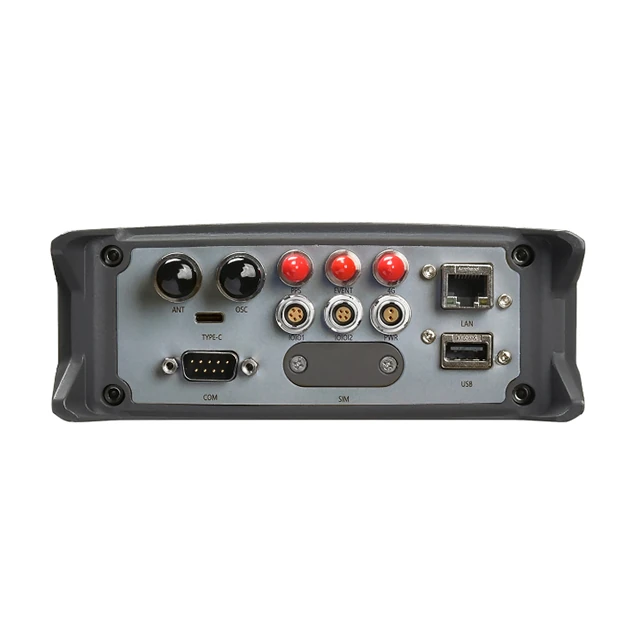
The receiver also includes interfaces for GNSS antenna connection, an oscillator, 4G antenna, PPS output, event input, RS232, RS485, Ethernet, USB storage and external power. This combination of modern network connectivity and traditional serial interfaces makes it easier to connect the N1 to existing infrastructure, timing equipment, industrial controllers, monitoring instruments and legacy systems.
FTP download and FTP push functions are supported for transferring data to or from a remote system. The exact setup will depend on the network design, SIM card, antenna arrangement, correction service and security requirements of the project.
Continuous Operation and Power Resilience
The SingularXYZ N1 is designed for installations that need to operate continuously rather than only during a daily survey shift. Its embedded Linux operating system provides a stable platform for receiver configuration, data management and network operation. The stated mean time between failures is greater than 20,000 hours, supporting its intended use in permanent GNSS infrastructure.
The receiver operates from a 9–28 V DC external power supply without the internal battery. An optional 16.75 Ah internal battery can provide up to sixteen hours of continuous operation, depending on the operating conditions and system configuration. This backup capability can help maintain data collection during short power interruptions and may reduce the risk of losing continuity in a monitoring or CORS installation.
For critical sites, the N1 can be incorporated into a wider power-management system that includes regulated power, surge protection, backup batteries, solar power or an uninterruptible power supply. As with any reference station, the quality of the external power system and antenna installation has a direct effect on overall reliability.
Onboard Storage and Data Protection
The N1 includes 8 GB of internal storage with loop recording, and the storage capacity can be expanded to 32 GB according to the required configuration. A loop-recording function is useful for long-term installations because the receiver can continue recording while automatically managing older files when storage capacity is reached.
Raw GNSS observations can be stored for later processing, system checks, monitoring records or project documentation. The receiver also includes a USB port for external data storage, giving field and network technicians an additional method for transferring or backing up data.
For structural monitoring, deformation studies, geodetic control and CORS operation, onboard storage provides an important second source of information. If a network connection is temporarily unavailable, locally recorded observations may still be available for review or post-processing, subject to the selected recording settings and available storage.
Web-Based Configuration and Local Status Display
The N1 can be configured and monitored through a browser-based WebUI accessed over Ethernet or Wi-Fi. The interface is designed for checking receiver status, managing data recording, configuring network and NTRIP settings, transferring data, upgrading the system and reviewing operational information.
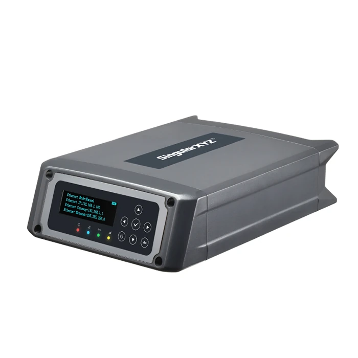
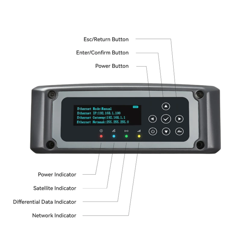
A 2.45-inch OLED display and physical buttons provide local access to key status information without requiring a separate computer for every adjustment. The front-panel controls include power, escape, enter and navigation buttons. LED indicators show information related to satellite tracking, RTK status, network connectivity and power.
This combination is useful for technicians working at remote sites. The display can help confirm whether the receiver is powered, tracking satellites and connected to the network, while the WebUI provides more detailed configuration and management when a laptop or network device is available.
Rugged Construction for Field and Infrastructure Sites
The receiver uses an aluminum alloy housing and is rated IP67 for protection against dust and temporary water immersion. It is designed to operate in temperatures from -40°C to +75°C and to be stored in temperatures from -55°C to +85°C. The specified humidity tolerance is up to 95% non-condensing.
The N1 is also designed to survive a one-meter drop onto concrete and includes MIL-STD-810 vibration resistance. These features make it suitable for equipment rooms, rooftop installations, infrastructure compounds, agricultural facilities, construction environments and other locations where vibration, dust, temperature changes or accidental handling may occur.
The receiver measures approximately 238 × 168 × 62 mm including connectors and weighs about 3 kg without the optional battery. This is a practical size for fixed mounting, cabinet installation or transport between sites, while still providing room for the communication and interface options required by professional reference-station systems.
Who Uses the SingularXYZ N1?
The N1 is intended for professional users who need a stable GNSS reference rather than a handheld navigation device. Surveying companies can use it as part of a local base station or CORS network that supplies corrections to field crews. Engineering firms and construction contractors can use reference-station data to support accurate site control, machine guidance, site positioning and verification work.
Infrastructure owners and monitoring specialists may use the receiver in systems that track bridges, buildings, dams, towers, rail corridors, embankments or other structures. In these applications, the N1 can provide continuous GNSS observations that are combined with other sensors or processed over time to identify movement and deformation.
GIS and geospatial organizations can use the N1 to support accurate field data collection, asset mapping, utility surveys, environmental monitoring and regional positioning services. Its support for RINEX and standard correction formats also makes it suitable for workflows where GNSS data must be transferred between different software platforms or shared with multiple teams.
Drone mapping and aerial survey teams may use the N1 as a fixed reference source for RTK or PPK operations, depending on the aircraft, payload and processing workflow. In this role, the N1 is normally installed as a base or reference station rather than mounted directly on the drone. The correct setup must be planned around the drone system, required accuracy, correction method and project control.
Precision agriculture and machine-control users can also benefit from a reliable local correction source. When integrated with compatible equipment, the N1 can help support repeatable positioning for automated steering, field operations, grading, excavation and other applications where consistent guidance is important.
Practical Advantages in the Field
- Tracks multiple GNSS constellations and frequencies to improve satellite availability for correction and observation work.
- Supports Ethernet, Wi-Fi, 4G, NTRIP, RTCM, RINEX and common serial interfaces for integration into professional systems.
- Provides onboard storage, loop recording and USB transfer for long-duration data collection and backup.
- Offers optional internal battery support for improved resilience during power interruptions.
- Uses an IP67 aluminum housing with vibration and drop-resistance features for demanding installations.
Important Considerations Before Choosing the N1
The SingularXYZ N1 is a reference-station receiver, so it should be selected as part of a complete GNSS infrastructure setup. It is not a complete rover kit by itself and does not replace a field controller, survey pole, rover antenna, correction subscription or suitable reference-station antenna. Buyers should consider the required antenna, monument or mounting arrangement, network connection, SIM card, power supply, correction platform and software before deployment.
Advertised RTK and post-processing accuracy should be understood as receiver performance under suitable conditions. Real-world results are affected by antenna quality, multipath, satellite geometry, atmospheric conditions, baseline length, correction age, installation stability and the control coordinate used for the station. A carefully installed antenna on a stable reference point is essential when the N1 is used for surveying, monitoring or CORS work.
For buyers comparing RTK GNSS equipment, the N1 is best considered when the project requires a robust fixed receiver with network connectivity, data recording and long-term operational capability. If the main requirement is carrying a receiver around a construction site to collect points, stake out features or map assets directly, a dedicated rover receiver and field controller may be more appropriate, possibly used together with an N1-based correction service.
Configuration and Support from Global GPS Systems
Global GPS Systems can help buyers select the correct configuration for their application, including the receiver setup, antenna requirements, communication method, power arrangement and intended correction workflow. This is especially useful when the N1 is being deployed as part of a CORS network, monitoring installation, machine-control system or professional survey infrastructure.
Before ordering, discuss the working environment, required accuracy, expected operating hours, available network coverage, data formats, mounting location and whether an internal backup battery or expanded storage is needed. Global GPS Systems can provide practical guidance so the SingularXYZ N1 is matched to the equipment and workflow it will be used with.
The SingularXYZ N1 provides a solid foundation for organizations that need accurate GNSS observations and correction data to remain available over long periods. Its combination of multi-constellation tracking, flexible communications, standard data formats, remote configuration, local controls, onboard recording and rugged construction makes it suitable for survey infrastructure, engineering, construction, GIS, monitoring, machine control, precision agriculture and drone-mapping support applications.
Datasheets & Manuals
Specifications
N1 Specifications
Product Overview
| Product type | Professional GNSS reference-station receiver |
|---|---|
| Primary function | Continuous GNSS observation, correction-data generation, CORS infrastructure and precision positioning support |
| Typical users | Surveyors, geodesists, CORS network operators, infrastructure monitoring teams, precision-agriculture professionals, construction specialists and geospatial-system integrators |
| Typical industries | Geospatial surveying, mapping, construction, infrastructure, transportation, mining, precision agriculture, geodesy, structural monitoring, utilities, research and telecommunications timing |
| Recommended deployment | Permanent reference stations, CORS networks, RTK correction services, monitoring installations, remote GNSS data collection and high-precision geospatial infrastructure |
| Operating system | Embedded Linux |
| CORS platform compatibility | Designed for integration with SingularCaster CORS network management platform |
Satellite Tracking
| Number of channels | 1408 |
|---|---|
| BDS | B1I, B2I, B3I, B1C, B2a and B2b |
| GPS | L1C/A, L1C, L2C, L2P(Y) and L5 |
| GLONASS | G1, G2 and G3 |
| Galileo | E1, E5a, E5b and E6 |
| QZSS | L1C/A, L1C, L2C and L5 |
| NavIC | L5 |
| SBAS | WAAS, EGNOS, SDCM, BDSBAS and GAGAN |
| L-band | Supported |
| Multi-constellation tracking | Simultaneous tracking of GPS, BDS, GLONASS, Galileo, QZSS, NavIC and supported augmentation systems |
| Interference mitigation | Designed for stable reception and high-quality GNSS observation data in challenging signal environments |
Positioning Accuracy
| Positioning mode | Horizontal accuracy | Vertical or 3D accuracy |
|---|---|---|
| Standalone | 1.5 m | 2.5 m |
| DGPS | 0.4 m | 0.8 m |
| Static post-processing | 2.5 mm + 0.5 ppm | 5 mm + 0.5 ppm |
| RTK | 8 mm + 1 ppm | 15 mm + 1 ppm |
| PPP | 5 cm | 10 cm |
| SBAS | Not separately specified | < 1.0 m 3D RMS |
| Time accuracy | Not applicable | 20 ns |
Initialization and Re-acquisition
| Cold-start time | < 30 seconds |
|---|---|
| Typical RTK initialization time | < 5 seconds |
| RTK initialization reliability | > 99.9% |
| Re-acquisition time | < 1 second |
| Selectable update rate | 1 to 20 Hz |
Data Formats and Protocols
| Data output formats | NMEA-0183, binary format *.xyz and RINEX 3.02 |
|---|---|
| Recorded storage formats | RINEX 3.02, RINEX 3.04 and binary format *.xyz |
| Correction-data formats | RTCM v3.0, v3.1, v3.2 and v3.3 |
| Network protocols | TCP, UDP, MQTT, Ntrip Server and Ntrip Caster |
| MQTT | Customizable |
| Ntrip functions | Ntrip Server and Ntrip Caster support |
| Raw GNSS data logging | Supported, including synchronous raw-data logging and loop recording |
Communication
| Ethernet | LAN Ethernet via RJ45 interface |
|---|---|
| 4G modem | Supported |
| Wi-Fi | IEEE 802.11 a/b/g/n/ac |
| FTP | FTP download and FTP push supported |
| NAT-DDNS | Supported |
| SIM card | Dedicated SIM card slot |
4G Cellular Bands
| FDD-LTE | B1, B3, B5, B7 and B8 |
|---|---|
| TDD-LTE | B38, B39, B40 and B41 |
| TD-SCDMA | B34 and B39 |
| WCDMA | B1, B2, B5 and B8 |
| GSM | B2, B3, B5 and B8 |
| CDMA | CDMA1x/CDMA2000 BC0 and BC1 |
Physical Interfaces
| TNC connectors | 2 total; one for the GNSS antenna and one for the oscillator |
|---|---|
| Type-C interface | 1; used for configuration and RS232 support |
| DB9 port | 1; used for the RS232 serial port |
| SMA connectors | 3 total; one for the 4G antenna, one for PPS output and one for Event input |
| Lemo ports | 3 total; one for RS485, one for RS232 and one for power supply |
| SIM card slot | 1 |
| RJ45 port | 1; LAN Ethernet |
| USB port | 1; external data storage and data download |
| PPS interface | Supported |
| Event interface | Supported |
| Oscillator interface | Supported |
| RS232 serial interface | Supported |
| RS485 serial interface | Supported |
Data Storage
| Internal storage | 8 GB |
|---|---|
| Maximum configurable storage | Up to 32 GB according to user requirements |
| External storage | Supported through the USB port |
| Loop recording | Supported |
| Storage purpose | Continuous GNSS raw-data recording, backup and data-transfer workflows |
Electrical Specifications
| Typical power consumption | 3.5 W |
|---|---|
| Input voltage without internal battery | 9 to 28 V DC |
| Input voltage with internal battery | 9 to 22 V DC |
| External power | Supported |
| Internal backup battery | Optional |
| Optional battery capacity | 16.75 Ah |
| Battery operating time | Up to 16 hours of continuous operation |
| Dual-power capability | External power supply with optional internal battery backup |
| Mean time between failures | More than 20,000 hours |
User Interface and Controls
| OLED display | 2.45-inch display for status and operating information |
|---|---|
| Web interface | Browser-based WebUI accessible through Wi-Fi or Ethernet |
| WebUI functions | Device configuration, real-time status checking, operating-mode setup, data-transfer settings, Ntrip configuration, data transfer, storage management, firmware upgrade and event-log review |
| Power button | 1 |
| Esc/return button | 1 |
| Enter/confirm button | 1 |
| Arrow buttons | 4 |
| LED indicators | 4; satellite tracking, RTK status, network and power supply |
Physical Specifications
| Dimensions | 238 × 168 × 62 mm, including connectors |
|---|---|
| Weight | 3 kg without battery |
| Housing material | Aluminum alloy |
| Housing design | Rugged industrial enclosure for permanent and demanding field installations |
Environmental Specifications
| Operating temperature | -40 °C to +75 °C |
|---|---|
| Storage temperature | -55 °C to +85 °C |
| Humidity | 95% non-condensing |
| Water and dust protection | IP67 |
| Drop resistance | Designed to survive a 1 m drop onto concrete |
| Vibration resistance | MIL-STD-810 |
| Suitable environments | Outdoor reference stations, infrastructure monitoring sites, remote installations, construction environments and other locations exposed to dust, water, vibration and temperature extremes |
Applications and Use Cases
| CORS networks | Permanent reference-station operation, correction-data generation, network management and rover-service support |
|---|---|
| Geodetic surveying | High-precision static observation, post-processing, RTK reference data and geodetic control networks |
| Infrastructure monitoring | Long-term monitoring of bridges, buildings, dams, towers, railways, roads, slopes and other structures |
| Precision agriculture | Reference-station support for machine guidance, field mapping, automated steering and precision positioning workflows |
| Construction and machine control | RTK correction infrastructure for site positioning, grading, machine guidance and construction surveying |
| Mining and quarrying | Reference positioning, site surveying, deformation monitoring and machine-control support |
| Transportation and utilities | Surveying and monitoring for roads, rail, ports, pipelines, power networks and other distributed infrastructure |
| Research and telecommunications | Precise GNSS observation, timing-reference applications and specialized positioning research |
Package / Included Items
| Item | Quantity | Notes |
|---|---|---|
| N1 GNSS receiver | 1 | Receiver unit; exact configuration should be confirmed before ordering |
| Internal backup battery | Optional | 16.75 Ah battery configuration is optional and may not be included as standard |
| GNSS antenna, cables, power supply and mounting accessories | Configuration dependent | Package contents are not fully specified in the reviewed product documentation |
Documentation and Configuration Notes
| Reviewed documentation | Manufacturer and distributor specifications for the N1 GNSS receiver and CORS solution |
|---|---|
| Specification revision referenced | December 12, 2024 receiver datasheet revision |
| Storage expansion | Internal storage may be configured up to 32 GB according to user requirements |
| Configuration dependency | 4G modem availability, internal battery, storage capacity, antenna accessories, cables and other package items may vary by configuration or region |
| Specification update notice | Specifications are subject to change without notice by the manufacturer |
Specifications and package contents may vary by configuration, region or manufacturer update. Always check the current configuration before ordering.
Reviews (0)
Only logged in customers who have purchased this product may leave a review.
FAQ
SingularXYZ N1 FAQ
Product Overview and Applications
What is the SingularXYZ N1 GNSS Receiver?
The SingularXYZ N1 is a professional GNSS reference-station receiver designed for continuous, high-accuracy positioning data. It is suitable for CORS networks, RTK correction services, geodetic infrastructure, monitoring systems, precision agriculture, machine control and other applications that require stable GNSS data.
Is the N1 a GNSS rover or a reference-station receiver?
The N1 is primarily designed as a permanent or semi-permanent reference-station receiver rather than a handheld field rover. It collects high-quality GNSS observations and can provide correction data to rovers, machines, monitoring systems and other connected devices.
Who uses the SingularXYZ N1?
Typical users include land-surveying companies, geodetic agencies, CORS network operators, infrastructure owners, civil engineering firms, construction companies, precision-agriculture providers, machine-control integrators, monitoring specialists, universities and research organizations.
Which industries can use the N1 GNSS Receiver?
The N1 can be used in surveying and mapping, geospatial information, construction, civil engineering, infrastructure development, precision agriculture, machine control, structural and slope monitoring, telecommunications, robotics, IoT and geodetic networks.
What functions does the N1 perform in a CORS network?
In a CORS network, the N1 tracks satellite signals, records raw GNSS observations, streams correction data, supports NTRIP services and communicates with network-management software. It can be deployed as part of a regional, national or private reference-station network.
Can the N1 be used for structural or deformation monitoring?
Yes. The N1 can provide continuous GNSS observations for infrastructure, bridge, dam, slope, subsidence and other deformation-monitoring projects. A complete monitoring system also requires a suitable antenna, installation, processing software, communications link and project-specific monitoring configuration.
GNSS Performance and Accuracy
Which satellite systems does the N1 support?
The N1 supports GPS, BeiDou, GLONASS, Galileo, QZSS and NavIC. It also supports SBAS services including WAAS, EGNOS, SDCM, BDSBAS and GAGAN, helping provide broad satellite availability across different regions.
How many GNSS channels does the SingularXYZ N1 have?
The N1 has 1,408 GNSS channels. Its high channel capacity allows it to track multiple signals and frequencies across supported satellite constellations at the same time.
What RTK accuracy can the N1 provide?
The published RTK accuracy is up to 8 mm + 1 ppm horizontally and 15 mm + 1 ppm vertically. Actual results depend on the antenna, correction source, baseline length, satellite visibility, multipath, atmospheric conditions, installation quality and the equipment used at the rover.
What accuracy is available during static post-processing?
The published static post-processing accuracy is 2.5 mm + 0.5 ppm horizontally and 5 mm + 0.5 ppm vertically. Post-processing performance depends on observation duration, antenna quality, satellite geometry, data quality and the processing workflow.
How quickly can the N1 initialize an RTK solution?
The typical RTK initialization time is less than five seconds, with a published initialization reliability of greater than 99.9% under suitable conditions. Initialization time can vary depending on correction data, satellite visibility, interference, baseline length and environmental conditions.
Does the N1 support raw GNSS data recording?
Yes. The N1 can record raw GNSS data in RINEX 3.02 or RINEX 3.04 format, as well as in SingularXYZ’s binary .xyz format. Recorded data can support post-processing, quality control, network administration and monitoring applications.
Connectivity, Protocols and Integration
Which communication protocols does the N1 support?
The N1 supports TCP, UDP, MQTT, NTRIP Server, NTRIP Caster, FTP and NAT-DDNS functions. MQTT is customizable according to the manufacturer’s specifications and integration requirements.
Does the N1 support NTRIP?
Yes. The receiver supports NTRIP Server and NTRIP Caster functions, allowing it to send or manage GNSS correction data in compatible RTK and CORS network configurations.
Can the N1 connect through Ethernet and 4G?
Yes. The N1 supports LAN Ethernet and an integrated 4G modem. It also supports Wi-Fi, allowing network operators to configure and monitor the receiver through a local or remote connection, subject to the network setup.
Which data formats does the N1 support?
The N1 supports NMEA-0183, SingularXYZ .xyz binary data, RINEX 3.02 and RINEX 3.04 for recorded data, and RTCM version 3.0, 3.1, 3.2 and 3.3 for correction data.
What physical interfaces are available on the N1?
The receiver includes GNSS antenna and oscillator connections, a 4G antenna connection, PPS output, event input, RS232, RS485, Ethernet, USB, Type-C, a SIM-card slot and power connections. These interfaces support network integration, timing, event synchronization, serial communications and external data storage.
Can the N1 integrate with SingularCaster?
Yes. The N1 is designed to integrate with the SingularCaster CORS platform. This combination can support reference-station management, rover and user administration, correction-data distribution, subscription management, monitoring and automated logging.
Installation, Operation and Durability
How is the N1 configured and monitored?
The receiver can be configured through its browser-based WebUI using Ethernet or Wi-Fi. The WebUI supports configuration, status checking, data transfer, data storage management and system upgrades. A 2.45-inch OLED display, buttons and LED indicators also provide local status and diagnostic information.
What storage capacity does the N1 have?
The standard internal storage is 8 GB and supports loop recording. Storage can be expanded to 32 GB according to project requirements, and the USB port can be used for external data storage.
Does the N1 have backup power?
The N1 supports external DC power and an optional internal 16.75 Ah battery. With the optional battery, the receiver can operate for up to approximately 16 hours continuously, depending on operating conditions and configuration.
What is the N1’s power consumption and input voltage?
The published power consumption is 3.5 W. Without the internal battery, the input voltage range is 9–28 V DC. With the internal battery, the specified input range is 9–22 V DC.
Can the N1 operate in harsh outdoor environments?
Yes. The N1 has an aluminum-alloy housing, IP67 protection against dust and water, MIL-STD-810 vibration resistance and a design intended to survive a one-metre drop onto concrete. Its published operating temperature range is -40 °C to +75 °C.
What are the dimensions and weight of the N1?
The receiver measures approximately 238 × 168 × 62 mm, including connectors. It weighs approximately 3 kg without the optional internal battery.


 GPS & GNSS
 Total Stations
 Data collectors
 Software
 Correction services
 Machine control
 External radio
 Marine
 Accessories
Reviews
There are no reviews yet