

 GPS & GNSS
 Lidar scanning
 Total Station
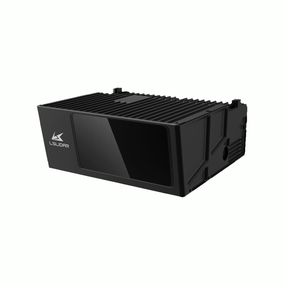
LS Lidar MS06 1200m Long Range Mapping LiDAR
Get the best price for your setup
Contact our experts for the best possible price and configuration.
- Fast response
- Expert configuration advice
- No overpaying for features you do not need
The LS Lidar MS06 is a long-range 3D LiDAR developed for mapping, surveying, UAV integration and mobile data-capture systems. Using a 1550 nm Time of Flight laser, it provides a maximum detection range of up to 1200 m, ±3 cm range accuracy and a wide 120° × 40° field of view. The sensor generates up to 400,000 points per second, giving mapping professionals and system integrators detailed point-cloud coverage over large areas and long working distances.
LS Lidar MS06 Highlights
| Maximum detection range | Up to 1200 m |
|---|---|
| Range accuracy | ±3 cm |
| Field of view | 120° horizontal × 40° vertical |
| Point rate | 400,000 points/sec |
| Laser wavelength | 1550 ±25 nm Class 1 |
| Angular resolution | 0.24° horizontal × 0.05° vertical |
| Protection | IP67 |
Valued customers:










Find RTK Networks
Search NTRIP providers and connect to reliable RTK correction services.
Description
Long Range 3D LiDAR for Mapping and Surveying
The LS Lidar MS06 is a long-range 3D LiDAR designed for mapping, surveying and professional sensor integration. With a maximum detection distance of up to 1200 metres, a wide 120° horizontal by 40° vertical field of view and ±3 cm range accuracy, it is suited to applications where large areas need to be captured efficiently from a vehicle, UAV or fixed platform.
The MS06 uses Time of Flight measurement technology and a 1550 nm laser to measure the distance between the sensor and surrounding surfaces. It produces a structured point cloud that can be combined with positioning and orientation data for mapping, terrain measurement and environmental modelling.
Up to 1200 Metres Detection Range
One of the main reasons to choose the MS06 is its long measurement range. The sensor is specified for a maximum detection distance of 1200 m, allowing it to collect information from terrain, structures and other objects at considerably greater distances than short-range industrial LiDAR systems.
For surveyors and mapping professionals, this can be useful when working from an elevated platform, moving vehicle or UAV where a larger working distance reduces the need to position the sensor close to every surface. Actual usable range will depend on target reflectivity, atmospheric conditions, installation and the surrounding environment.
Wide 120 Degree by 40 Degree Field of View
The MS06 covers 120° horizontally and 40° vertically. This wide viewing area allows the LiDAR to collect data across a broad section of the surrounding environment during each scan.
In practical mapping work, a wider field of view means more terrain or infrastructure can be captured from each sensor position. This is valuable for mobile mapping vehicles, UAV payloads and other moving platforms because it can improve overall coverage and reduce gaps between adjacent scan areas.
400000 Points Per Second
The LiDAR generates up to 400,000 measurement points per second. These points provide the spatial information needed to represent terrain, structures, vegetation and other surfaces in three dimensions.
For users creating point clouds, digital terrain information or other spatial datasets, the point rate provides a balance between coverage and manageable data volumes. It is particularly suitable for applications where long-range coverage is more important than producing several million points every second at close range.
±3 cm Range Accuracy
The MS06 provides a specified range accuracy of ±3 cm. This makes it suitable for mapping and measurement applications that require consistent centimetre-level distance information across large areas.
Range accuracy describes the LiDAR measurement itself. The final accuracy of a georeferenced point cloud also depends on the GNSS receiver, IMU, calibration, mounting accuracy and processing workflow used with the sensor. For mobile or airborne mapping, these components should therefore be considered as part of one complete measurement system.
1550 nm Time of Flight LiDAR
The MS06 uses a 1550 ±25 nm laser and Time of Flight measurement principle. The LiDAR emits laser pulses and measures how long each pulse takes to travel to a surface and return. From this travel time, the sensor calculates the distance to the measured point.
The laser system is classified as Class 1 eye safe when the product is operated according to its specified conditions. The 1550 nm architecture is particularly suited to professional long-range LiDAR applications where extended detection distance is required.
Angular Resolution for Detailed Surface Capture
The sensor provides an angular resolution of approximately 0.24° horizontally and 0.05° vertically, with specified angular precision of 0.02°. These figures determine how closely measurements are spaced across the field of view and how consistently the LiDAR can determine their direction.
For mapping, this helps build an organised point cloud across terrain and structures. Point spacing at the object will naturally increase as measurement distance increases, so project requirements should be considered when determining the appropriate flight height, vehicle distance or mounting position.
Integration with GNSS and Positioning Systems
The MS06 includes a RS422 synchronization interface and supports external timing. The user manual also describes GPS and gPTP synchronization functions. Accurate timing is essential when point-cloud measurements are combined with GNSS and IMU data on a moving platform.
For a mobile mapping or UAV system, the LiDAR measures the surrounding environment while GNSS determines platform position and an IMU records its orientation and movement. Synchronizing these datasets allows processing software to place the LiDAR points into the correct real-world coordinates.
Fast Ethernet Point Cloud Output
Point-cloud data is transferred through Fast Ethernet. This provides a standard network connection for linking the LiDAR to an onboard computer or data-logging system.
The MS06 can be operated with LS Lidar point-cloud software under Windows, while a ROS driver is available for Linux-based systems. This makes the sensor suitable both for finished mapping platforms and for engineers developing their own LiDAR integration.
Built for Outdoor Mapping Systems
The MS06 is specified with an IP67 environmental protection rating and an operating temperature range from -45°C to +70°C. This makes it suitable for integration into equipment intended for outdoor mapping and demanding environmental conditions.
The unit measures approximately 242.3 × 220 × 96 mm and weighs around 4 kg. Power is supplied at 28 VDC and rated power consumption is approximately 100 W. These requirements should be taken into account when designing a UAV payload, vehicle installation or fixed scanning platform.
Typical Applications
- UAV and airborne LiDAR mapping
- Mobile mapping systems
- Topographic and terrain data capture
- Infrastructure and corridor surveying
- Environmental and geographic mapping
- Vehicle mounted 3D scanning
- Custom GNSS IMU LiDAR integrations
Using the MS06 in a Surveying Workflow
The MS06 should be considered a LiDAR sensor rather than a complete survey system. To produce accurately georeferenced mapping data from a moving platform, it will normally be combined with GNSS, an IMU, a computer or data logger and suitable point-cloud processing software.
This modular approach is useful for system integrators, drone manufacturers and mapping professionals who want to build a sensor package around their own positioning and processing workflow. The long range is particularly attractive for projects where large ground areas need to be captured efficiently.
Buying the LS Lidar MS06 from Global GPS Systems
Global GPS Systems supplies LiDAR, GNSS and professional positioning equipment for surveying, construction, UAV and mapping projects worldwide. Our team can help evaluate whether the MS06 matches your required range, field of view, platform payload and positioning setup.
When the LiDAR is being integrated with GNSS, an IMU or a custom mobile mapping platform, choosing the complete sensor configuration is just as important as selecting the LiDAR itself. Global GPS Systems can assist with matching the components to the intended field workflow and required output.
Specifications
LSLiDAR MS06 / MS06-B Long-Range 3D LiDAR Specifications
Product Overview
| Product name | LSLiDAR MS06 |
|---|---|
| Documented hardware model | MS06-B |
| Product type | Ultra-long-range 3D scanning LiDAR |
| Primary technology | 1550 nm Time-of-Flight (ToF) LiDAR |
| Primary applications | Airborne obstacle avoidance, helicopter and eVTOL perception, UAV mapping, general aviation, inspection, rescue, transportation and long-range 3D mapping |
| Standard documented range | Up to 1200 m |
| Extended manufacturer option | Current LSLiDAR product information states that the MS06 platform can be customized for detection ranges up to 2000 m |
| Point cloud rate | 400,000 points/second |
| Field of view | 120° horizontal × 40° vertical |
Laser and Ranging Specifications
| Detection method | Time of Flight (ToF) |
|---|---|
| Laser wavelength | 1550 ±25 nm |
| Laser class | Class 1, eye-safe |
| Maximum standard detection range | 1200 m |
| Custom extended range | Up to 2000 m according to current LSLiDAR MS06 product information |
| Range accuracy | ±3 cm |
| Point generation rate | 400,000 points/second |
| Scanning rate | 1 Hz |
| Echo intensity | 0–255 intensity value in the documented point data |
| Distance data resolution in protocol | 1 mm |
Field of View and Angular Performance
| Horizontal field of view | 120° |
|---|---|
| Vertical field of view | 40° |
| Combined field of view | 120° × 40° (H × V) |
| Horizontal angular resolution | 0.24° |
| Vertical angular resolution | 0.05° |
| Angular precision | 0.02° |
| Horizontal angle range in protocol | -60° to +60° |
| Horizontal angle data unit | 0.01° |
| Vertical angle data unit | 0.0025° |
Long-Range Detection Capabilities
| Small-object detection | Designed for long-range detection of small objects |
|---|---|
| Low-reflectivity target detection | 1550 nm architecture is designed to detect weak reflected signals and low-reflectivity targets |
| Power-line detection application | Manufacturer documentation describes detection of weak-return targets such as high-voltage power lines from distances exceeding 300 m under suitable conditions |
| Lighting dependence | Active LiDAR measurement allows operation independent of visible ambient lighting |
| 24-hour operation | Designed for day and night ranging and mapping applications |
Point Cloud Data
| Point cloud output | 3D measured point cloud |
|---|---|
| Horizontal angle | Included |
| Vertical angle | Included |
| Distance | Included |
| Echo intensity | Included |
| UTC information | Included when valid synchronization information is available |
| Timestamp | Included |
| 3D coordinate calculation | Measured range and angular information can be converted to Cartesian X, Y and Z coordinates |
| Point intensity range | 0–255 |
Echo Modes
| Documented standard MSOP operation | Single-echo mode measuring the most recent echo value |
|---|---|
| Protocol echo identification | Protocol definitions include identification for single-echo and dual-echo LiDAR configurations |
| Single-echo additional data | 14 bytes |
| Dual-echo additional data definition | 18 bytes in the documented communication protocol |
Communication Interface
| Primary communication interface | Fast Ethernet |
|---|---|
| Transport protocol | UDP/IP |
| Ethernet TX | Differential TX+ / TX− pair |
| Ethernet RX | Differential RX+ / RX− pair |
| GNSS / timing interface | RS-422 synchronization interface |
| Main connection cable | 17-pin industrial Ethernet / power / synchronization cable |
| Shield ground | Dedicated PE / cable shield connection |
UDP Communication Protocols
| Protocol | Function | Packet / Interval |
|---|---|---|
| MSOP | Main Stream Output Protocol for measured distance, angle, intensity and timestamp data | 1248 bytes; approximately 0.06712 ms interval |
| DIFOP | Device Information Output Protocol for configuration, operating status and diagnostics | 1248 bytes; normally 1 packet/second |
| UCWP | User Configuration Write Protocol for configurable device parameters | Variable transmission interval |
MSOP Packet Structure
| Total Ethernet packet size | 1248 bytes |
|---|---|
| Ethernet header | 42 bytes |
| Payload | 1206 bytes |
| Measured point data | 1192 bytes |
| Points per standard single-echo packet | 149 |
| Bytes per measured point | 8 |
| Additional information – single echo | 14 bytes |
| Byte order | Big-endian |
| Frame-start marker | FF AA BB CC DD EE 11 22 in the documented MSOP stream |
Network Configuration
| Default LiDAR IP address | 192.168.1.200 |
|---|---|
| Default host / destination IP | 192.168.1.102 |
| LiDAR device packet port | 2368 |
| LiDAR data packet port | 2369 |
| Default computer device packet port | 2369 |
| Default computer data packet port | 2368 |
| Default subnet mask example | 255.255.255.0 |
| IP reconfiguration | Supported through the UCWP configuration protocol |
| Destination IP reconfiguration | Supported |
| Data / device port configuration | Supported through the documented configuration protocol |
Time Synchronization
| GPS synchronization | Supported |
|---|---|
| External PPS synchronization | Supported |
| gPTP synchronization | Supported |
| Internal timing | Automatically used when no external synchronization signal is available |
| Standard point-cloud timestamp resolution | Microseconds |
| gPTP time unit | Nanoseconds |
| GPS serial standard | RS-422 |
| GPS NMEA sentence | $GPRMC |
| GPS serial baud rate | 9600 baud |
| GPS serial format | 8 data bits, no parity, 1 stop bit |
| GPS PPS pulse width | Greater than 1 ms |
| External synchronization PPS level | 3.3–5 V |
| External PPS trigger | Rising edge |
GNSS / INS Integration
| GNSS synchronization interface | RS-422 serial + PPS |
|---|---|
| UTC date / time | Extracted from compatible GPS $GPRMC messages |
| Latitude | Can be parsed and output from compatible GPS data |
| Longitude | Can be parsed and output from compatible GPS data |
| INS integration | Precise LiDAR timestamps can be associated with pitch, roll, yaw, latitude, longitude and height from an external GNSS / inertial navigation system |
| Mapping integration | Designed for synchronized airborne and mobile mapping configurations |
Electrical Specifications
| Operating voltage | 28 VDC |
|---|---|
| Allowed supply fluctuation | Keep output fluctuations within approximately ±10% according to the User Manual |
| Power consumption | 100 W |
| Power connection | Multiple dedicated positive and power-ground pins in the 17-pin LiDAR connector |
| Protective earth | Shield / PE connection provided |
Connector Pin Functions
| Pins | Function |
|---|---|
| 2 / 3 | Ethernet TX+ / TX− |
| 6 / 7 | Ethernet RX− / RX+ |
| 4 / 5 | RS-422 PPS RX+ / RX− |
| 8 / 9 | RS-422 serial RX+ / RX− |
| 1 | RS-422 signal ground |
| 10 / 11 / 12 / 13 | Power positive |
| 14 / 15 / 16 / 17 | Power ground |
| Connector shell | Protective earth / shield ground |
Environmental Specifications
| Operating temperature | -45°C to +70°C |
|---|---|
| Storage temperature | -55°C to +85°C |
| Ingress protection | IP67 |
| Outdoor operation | Designed for airborne and external long-range sensing applications |
| Day / night operation | Supported by active laser ranging |
Physical Specifications
| Dimensions – MS06-B User Manual | 242.3 × 220 × 96 mm |
|---|---|
| Dimensions – current manufacturer product page | Approximately 243 × 220 × 96 mm |
| Weight | Approximately 4.0 kg |
| Main mounting points | Mechanical mounting points shown in the manufacturer MS06-B drawing |
| Documented side fixing threads | M5 / M6 mounting features shown in the mechanical drawing |
| Optical window | Protective transport film must be removed before operation |
Windows Software
| Windows operation | Supported |
|---|---|
| Manufacturer application | LSLiDAR Windows Client / point-cloud display software |
| Operating system architecture | Windows x64 |
| Live point-cloud viewing | Supported |
| Offline point-cloud playback | Supported |
| Point-cloud recording | Supported |
| Zoom / pan / rotate | Supported |
| Point marking | Supported |
| Point-to-point distance measurement | Supported |
| Coordinate display | Supported |
| LiDAR parameter configuration | Supported |
| LiDAR testing | Supported |
| Fault detection | Supported |
| Windows packet-capture dependency | WinPcap documented |
| Network diagnostics | Wireshark can be used for ARP and packet analysis |
Windows Host Computer Requirements
| Component | Manufacturer Requirement / Recommendation |
|---|---|
| Operating system | 64-bit Windows |
| Processor | Intel Core i5 or higher |
| Graphics card | NVIDIA GeForce GTX 750 or higher recommended for best point-cloud display performance |
| Graphics API | OpenGL 2.0 or newer required for normal point-cloud display |
| Ethernet | Compatible wired Ethernet adapter required |
Linux and ROS Support
| Linux operation | Supported |
|---|---|
| Manufacturer ROS driver | Supported |
| ROS driver package | lslidar_ms06_driver |
| ROS launch workflow | Manufacturer documentation includes a dedicated lslidar_ms06 launch configuration |
| RViz visualization | Supported |
| PointCloud2 output | Supported in the documented ROS visualization workflow |
| Linux network diagnostics | Ping and standard Linux network tools can be used to verify communication |
Device Configuration and Diagnostics
| LiDAR local IP | Configurable |
|---|---|
| Destination IP | Configurable |
| Subnet mask | Configurable |
| Gateway | Configurable |
| Data port | Configurable through the documented configuration protocol |
| Device port | Configurable through the documented configuration protocol |
| Clock source | Configurable for applicable synchronization modes |
| Device status reporting | Supported through DIFOP |
| Firmware / version information | Available in device information data |
| Fault diagnosis | Supported |
| Latitude / longitude reporting | Available when valid GPS information is supplied |
Typical Applications
| Application | Typical MS06 Function |
|---|---|
| Helicopters | Long-range obstacle and terrain detection |
| eVTOL / flying cars | Long-range anti-collision perception |
| UAV / drones | Obstacle detection and synchronized 3D mapping |
| General aviation aircraft | Long-range environmental perception |
| Power-line detection | Detection of thin and low-reflectivity airborne obstacles under suitable conditions |
| Transportation | Long-distance environmental and obstacle sensing |
| Inspection | Remote 3D data acquisition |
| Rescue | Long-range environmental sensing and scene mapping |
| 3D mapping | 400,000-point/s synchronized point-cloud acquisition |
| Mobile / airborne mapping | Integration with external GNSS / INS using GPS, PPS or gPTP synchronization |
Documented Software and Integration Items
| Item | Quantity | Notes |
|---|---|---|
| MS06 / MS06-B LiDAR | 1 | Exact range configuration depends on supplied hardware |
| 17-pin interface cable | Configuration-dependent | Combines Ethernet, power and RS-422 synchronization connections |
| LSLiDAR Windows Client | 1 software package | Documented as supplied on USB media or available through LSLiDAR support |
| ROS driver | 1 software package | Linux / ROS point-cloud driver |
| WinPcap | 1 software package | Documented dependency for the Windows Client |
Documentation and Configuration Notes
| User Manual researched | MS06-B User Manual V1.0.2, April 2024 |
|---|---|
| Global GPS Systems listed model | LS LiDAR MS06 using MS06-B technical documentation |
| Standard documented range | 1200 m |
| Current manufacturer range option | LSLiDAR's current MS06 product page states 1200 m standard detection range with customization up to 2000 m |
| Dimensions documentation difference | The MS06-B User Manual specifies 242.3 × 220 × 96 mm; the current manufacturer page rounds this to approximately 243 × 220 × 96 mm |
| Extended-range configuration | The 2000 m figure represents a customized MS06 configuration and should not be assumed for the standard MS06-B without confirmation |
| Integration requirement | Power supply, Ethernet, GNSS / INS synchronization and mechanical installation should be engineered for the exact production configuration |
Specifications and package contents may vary by configuration, region or manufacturer update. Always check the current configuration before ordering.
Reviews (0)
Only logged in customers who have purchased this product may leave a review.
FAQ
LS LiDAR MS06 FAQ
MS06 LiDAR & Applications
What is the LS LiDAR MS06?
The LS LiDAR MS06-B is a long-range 3D Time of Flight LiDAR sensor designed for mapping, aerial platforms, obstacle detection, inspection and other applications requiring detailed long-distance point cloud data. It combines a 120° horizontal by 40° vertical field of view with a maximum specified detection range of 1200 metres and distance accuracy of approximately ±3 cm.
Is the LS LiDAR MS06 a 3D LiDAR scanner?
Yes. The MS06 scans across both horizontal and vertical angles to produce three-dimensional point cloud data. Its 120° horizontal and 40° vertical field of view allows it to capture a large area in front of the sensor rather than measuring only a single laser point.
What is the LS LiDAR MS06 designed for?
The MS06 is particularly suited to long-range mapping, aerial surveying, helicopter and aircraft obstacle detection, infrastructure inspection, transportation, rescue and specialised autonomous-platform applications. Its combination of long range, wide field of view and centimetre-level ranging accuracy makes it useful where objects need to be detected and mapped from substantial distances.
Can the LS LiDAR MS06 be used for drone or UAV mapping?
Yes. The MS06 can be integrated into suitable UAV and airborne mapping systems. To create an accurately georeferenced point cloud from a moving platform, the LiDAR is normally combined with GNSS and inertial navigation equipment and correctly calibrated relative to the aircraft or UAV.
Can the MS06 be used for helicopter collision avoidance?
Yes. LS LiDAR specifically identifies helicopter and aviation collision avoidance as applications for the MS06. Its long detection range allows a suitable perception system to detect objects ahead of an aircraft, including small or difficult targets. The LiDAR itself supplies the measurement data and must be integrated with the aircraft's processing and warning systems.
How does the LS LiDAR MS06 measure distance?
The MS06 uses Time of Flight, or ToF, measurement. It emits laser pulses and measures the time required for the reflected light to return from a target. Since the speed of light is known, this travel time is converted into a distance measurement and combined with the laser angle to create 3D point cloud coordinates.
Range, Accuracy & Point Cloud Performance
What is the maximum detection range of the LS LiDAR MS06?
The MS06-B has a specified maximum detection range of 1200 metres. LS LiDAR also states that customised MS06 configurations can extend the maximum range to approximately 2000 metres. Actual detection distance depends on factors such as target reflectivity, target size, atmospheric conditions and installation.
How accurate is the LS LiDAR MS06?
The MS06-B has a specified distance accuracy of approximately ±3 cm. This is the LiDAR's ranging specification; the accuracy of a complete mobile or aerial mapping system also depends on factors such as GNSS/INS performance, timing, boresight calibration, mounting stability and processing.
What is the field of view of the MS06?
The MS06-B provides a 120° horizontal field of view and a 40° vertical field of view. This wide viewing area enables the sensor to capture a substantial three-dimensional section of the environment in front of the LiDAR.
How many points per second does the MS06 generate?
The MS06-B generates approximately 400,000 measurement points per second. These measurements form the point cloud used for mapping, detection, inspection and other spatial-analysis applications.
What is the angular resolution of the LS LiDAR MS06?
The MS06-B has a specified angular resolution of approximately 0.24° horizontally by 0.05° vertically, with angular precision specified at approximately 0.02°. This combination enables relatively dense spatial sampling across its wide field of view.
What is the scanning rate of the MS06?
The MS06-B has a specified scanning rate of 1 Hz. Each scan covers the sensor's 120° horizontal by 40° vertical field of view while the LiDAR continuously generates measurement points for the connected processing system.
Laser, Connectivity & Mapping Integration
What laser wavelength does the LS LiDAR MS06 use?
The MS06-B uses a 1550 nm laser with a specified wavelength tolerance of ±25 nm. This wavelength is particularly suitable for high-performance long-range LiDAR applications.
Is the LS LiDAR MS06 eye-safe?
Yes. The MS06-B is specified as a Class 1 eye-safe laser product and is designed to comply with applicable IEC laser-safety requirements. The manufacturer still advises users to avoid intentionally looking directly into an operating LiDAR and not to view the transmitting laser through magnifying optical equipment.
How does the MS06 connect to a computer?
The MS06-B uses Fast Ethernet for communication with an external computer or processing system. Point cloud and device data are transmitted over the network, allowing real-time visualisation, recording and integration into mapping or perception software.
Does the MS06 support GNSS time synchronization?
Yes. The MS06-B provides an RS-422 synchronization interface and supports GNSS/GPS-based timing. Its documentation also describes external synchronization and gPTP timing options. Precise synchronization is particularly important when LiDAR data is combined with GNSS, an IMU or other sensors on a moving platform.
Can the LS LiDAR MS06 be used with Windows and Linux?
Yes. LS LiDAR provides a Windows client for viewing and configuring the sensor and a ROS driver for Linux-based operation. The Windows client can display point clouds, configure parameters, perform sensor testing and record data, while ROS support makes the sensor suitable for robotics and custom development workflows.
Can MS06 point cloud data be recorded for later processing?
Yes. The LS LiDAR Windows client supports recording incoming point cloud data and opening recorded data for offline playback and analysis. The interface also provides tools for inspecting the point cloud and measuring the distance between selected points.
Power, Durability & Installation
What power supply does the LS LiDAR MS06 require?
The MS06-B requires a nominal 28 VDC power supply. The manufacturer specifies that voltage fluctuations should be kept within approximately 10% of the required input voltage. Its specified power consumption is approximately 100 W.
Is the LS LiDAR MS06 waterproof and dustproof?
Yes. The MS06-B has an IP67 environmental protection rating. This provides protection against dust and temporary water immersion when the LiDAR and its connections are installed and maintained according to the manufacturer's instructions.
What temperature range can the MS06 operate in?
The MS06-B has a specified operating temperature range of approximately -45°C to +70°C and a storage temperature range of approximately -55°C to +85°C. This wide range is intended to support demanding outdoor, aerial and industrial environments.
How large is the LS LiDAR MS06?
The MS06-B measures approximately 242.3 × 220 × 96 mm. Its housing is designed for fixed integration into aircraft, mapping platforms, vehicles and other systems where the sensor's position and viewing direction can be rigidly controlled.
How much does the LS LiDAR MS06 weigh?
The MS06-B weighs approximately 4.0 kg. When integrating it on a UAV or aircraft, the complete payload calculation should also include mounting hardware, power equipment, cabling, GNSS/INS equipment and any onboard computer used for recording or processing the LiDAR data.
What should be considered when installing the MS06 for mapping?
The LiDAR should be mounted rigidly with an unobstructed field of view and adequate protection for its optical window and connections. For mobile or airborne mapping, the exact position and orientation of the MS06 relative to the GNSS antenna and IMU must be determined accurately. Correct time synchronization and boresight calibration are also important for producing consistent georeferenced point clouds.

 GPS & GNSS
 Total Stations
 Data collectors
 Software
 Correction services
 Machine control
 External radio
 Marine
 Accessories
Reviews
There are no reviews yet