

 GPS & GNSS
 Lidar scanning
 Total Station
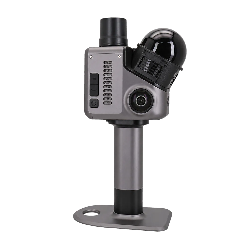
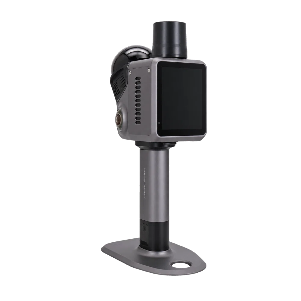
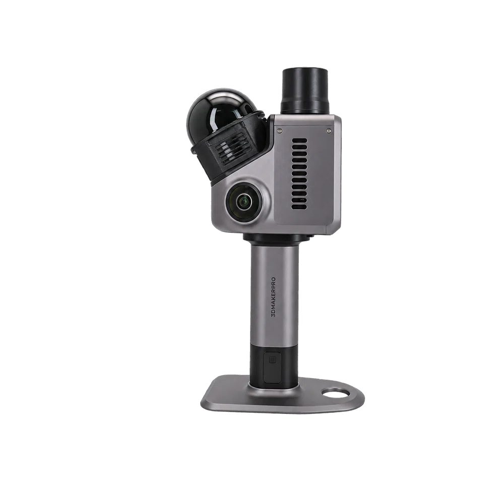
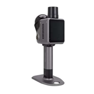
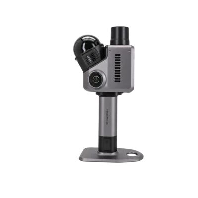
3DMakerpro Hawk Handheld LiDAR 3D Scanner with 140m Range
Get the best price for your setup
Contact our experts for the best possible price and configuration.
- Fast response
- Expert configuration advice
- No overpaying for features you do not need
The 3DMakerpro Hawk is a portable handheld LiDAR 3D scanner designed for fast, detailed mapping of buildings, construction sites, industrial facilities and outdoor environments. Capturing up to 480,000 points per second with an accuracy of 1.5 cm at 10 m, it helps surveyors, engineers and inspection teams create detailed 3D records without relying on numerous individual measurements.
With a scanning range of up to 140 m, dual 13 MP cameras for colour capture and a 360° horizontal field of view, the Hawk combines spatial measurement and visual documentation in one compact device. Its IP65-rated metal housing, integrated AMOLED screen and removable battery grip make it practical for fieldwork, while RayStudio software supports processing and exporting 3D point clouds and models.
3DMakerpro Hawk Highlights
| Scanning technology | LiDAR with multi-echo measurement and NIR visual tracking |
|---|---|
| Accuracy | 1.5 cm at 10 m; 3 cm at 20 m; 5 cm at 40 m |
| Scanning range | 80–140 m, depending on target reflectivity |
| Point cloud capture | Up to 480,000 points per second |
| Field of view | 360° horizontal; 63.5° vertical |
| Colour imaging | Dual 13 MP cameras with 1-inch sensors |
| Field protection | IP65-rated metal housing |
| Battery and weight | 12,000 mAh removable battery grip; up to 1 hour operation; 900 g scanner weight |
| Data output | PLY point clouds, Gaussian Splatting PLY and OBJ models |
You may also like…
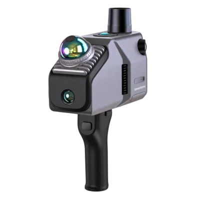
Slam Lidar scanner
3DMakerpro Eagle Max SLAM LiDAR Scanner with Four 48MP Cameras
Valued customers:






Find RTK Networks
Search NTRIP providers and connect to reliable RTK correction services.
Description
3DMakerpro Hawk Professional Handheld LiDAR 3D Scanner
The 3DMakerpro Hawk is a professional handheld LiDAR scanner developed for capturing accurate 3D data of buildings, construction sites, industrial installations and outdoor environments. Combining high-speed laser scanning with colour imaging, the Hawk allows surveyors, engineers and construction professionals to document existing conditions and create detailed digital representations of real-world spaces.
With a scanning range of up to 140 metres, a point cloud capture rate of 480,000 points per second and a compact design weighing approximately 900 grams, the Hawk is built for projects where mobility, efficient data collection and reliable 3D documentation are important. It can be used for architectural surveys, site inspections, as-built documentation, infrastructure mapping and digital twin projects.
Fast LiDAR Scanning with Centimetre-Level Accuracy
The Hawk uses LiDAR technology to measure surrounding surfaces and create dense three-dimensional point clouds. Its specified accuracy is 1.5 cm at 10 metres, 3 cm at 20 metres and 5 cm at 40 metres. This enables professionals to capture the geometry of rooms, building facades, structures and industrial equipment with a useful level of detail for spatial documentation and planning.
With a scanning frequency of up to 480,000 points per second, the device collects large amounts of spatial information while moving through an environment. Instead of manually measuring every wall, column or structural feature, users can record the overall geometry of an area and examine the resulting 3D dataset afterwards. Multi-echo LiDAR technology also supports data acquisition in environments containing different surfaces and objects.
The scanner provides a 360-degree horizontal field of view and a 63.5-degree vertical field of view. This wide scanning coverage helps capture floors, walls, ceilings and surrounding structures during a scanning session, reducing the need for repeated repositioning in many environments. Actual coverage and accuracy depend on distance, surface reflectivity, visibility and scanning conditions.
Up to 140 Metres Scanning Range for Indoor and Outdoor Projects
The Hawk has a specified scanning range of 80 to 140 metres, depending on the reflectivity of the target surface. This makes it suitable for capturing everything from building interiors and industrial spaces to larger outdoor areas and infrastructure features.
For construction professionals, the extended range is useful when documenting building exteriors, site layouts, structural elements and areas that are difficult to access directly. Surveyors and mapping specialists can use the scanner to collect spatial information across larger environments, while inspection teams can capture existing conditions for maintenance planning, renovation work or comparison with design models.
Dual 13 MP Cameras for Colour 3D Documentation
In addition to its LiDAR measurement system, the 3DMakerpro Hawk features two 13 MP cameras with 1-inch sensors. These cameras capture visual information that can be combined with the point cloud to produce colourised 3D data and textured models.
Colour information helps users recognise materials, surfaces and individual objects within a scanned environment. This is particularly valuable for building inspections, architectural documentation, industrial facilities and digital twin applications, where understanding the appearance of a space can be just as important as its geometry.
An integrated near-infrared (NIR) visual tracking system supports motion tracking during scanning, including in challenging lighting conditions. By combining visual tracking and LiDAR measurements, the Hawk is designed to support consistent spatial capture while users move through a project area.
Portable Scanning for Construction Sites and Fieldwork
Designed for mobile use, the Hawk combines a compact 120 × 145 × 85 mm scanner body with an IP65-rated metal housing. The enclosure provides protection against dust and water jets, making it suitable for demanding working environments such as construction sites, workshops and outdoor project locations.
The scanner weighs approximately 900 grams, making it manageable for handheld scanning tasks. Its metal construction also helps dissipate heat during operation. Depending on the project setup, the Hawk can be used handheld or integrated into supported tripod and mobile mounting configurations.
A built-in 3.9-inch AMOLED display allows users to configure scanning settings, monitor data acquisition and review scan results directly on the device. This reduces the need to constantly operate a separate computer while collecting data in the field.
Removable Battery Grip and Practical Data Connectivity
The Hawk uses a removable 12,000 mAh battery grip, providing approximately one hour of operation under specified conditions. The battery supports 65 W fast charging, with a stated charging time of approximately 30 minutes from 0 to 80%. A spare battery grip can help support longer scanning sessions, while external power can be used where a suitable supply is available.
For data management, the scanner includes two USB Type-C connections, Wi-Fi 5 connectivity and support for expandable storage using a TF memory card. These options help users transfer collected scan data and manage projects between the field and office.
RayStudio Software for Point Cloud Processing and 3D Models
After scanning, captured data can be processed using RayStudio, the companion software for 3DMakerpro LiDAR scanners. The software supports point cloud processing, including noise removal, filtering and optimisation, helping users prepare their scanned environments for further inspection, modelling and visualisation.
Supported output formats include colour point clouds in PLY format, Gaussian Splatting data in PLY format and coloured polygonal models in OBJ format. These formats provide flexibility for visualisation, 3D modelling and downstream applications, subject to the import capabilities of the software being used.
For architectural and construction workflows, processed scans can serve as a reference when preparing existing-condition drawings, renovation concepts and 3D building models. For digital twin and visualisation projects, colour information and Gaussian Splatting can help create realistic representations of scanned environments. Gaussian Splatting processing requires a compatible NVIDIA GPU.
Applications for Surveying, Construction and 3D Mapping
The 3DMakerpro Hawk is suitable for professionals who need to capture the shape, dimensions and visual characteristics of physical environments without relying entirely on individual point measurements.
- Land surveying and spatial documentation: Capture site features, structural geometry and existing environments as detailed 3D point clouds.
- Construction and renovation: Record building conditions, document progress and collect reference data for refurbishment or construction planning.
- Architecture and building measurement: Scan rooms, facades and complete interior spaces to support existing-condition models and design work.
- Industrial inspection: Document machinery areas, production facilities, pipework and complex installations for inspection and maintenance planning.
- Infrastructure and civil engineering: Capture visible features of roads, bridges, structures and surrounding environments for 3D documentation.
- GIS and digital twin projects: Produce spatial datasets and visual 3D representations for asset management and digital mapping workflows.
Integrating LiDAR Scanning with Surveying Workflows
The Hawk includes an interface for an external positioning accessory and supports workflows involving GPS information and scan control points. These capabilities can assist with organising and positioning scanning projects.
For projects requiring reliable coordinates in a defined survey reference system, suitable control points, positioning equipment and verification procedures should be used. The scanner’s stated LiDAR accuracy describes its spatial measurement performance and should not be confused with independently verified absolute GNSS or RTK positioning accuracy.
This distinction is especially important for engineering surveys, GIS datasets and projects where scanned information must align with existing survey control or design coordinates.
Why Choose the 3DMakerpro Hawk?
The Hawk brings together high-density LiDAR capture, colour cameras, portable hardware and dedicated processing software in a single 3D scanning solution. It is particularly useful for teams that need to document complex environments efficiently and work with detailed point clouds rather than relying only on photographs or individual measurements.
Its combination of a wide field of view, centimetre-level specified accuracy, extended scanning range and field-ready construction makes it a practical choice for building documentation, industrial surveys, construction inspection and spatial visualisation.
3DMakerpro Hawk at Global GPS Systems
At Global GPS Systems, we help surveying, construction and engineering professionals select equipment that fits their fieldwork and data processing requirements. Whether you need a portable LiDAR scanner for building documentation, industrial inspection or 3D mapping, our team can help you understand how the 3DMakerpro Hawk fits into your existing workflow.
We can also advise on positioning equipment, data processing requirements and compatible surveying solutions for projects that combine LiDAR scanning with GNSS measurements.
Datasheets & Manuals
Specifications
3DMakerpro Hawk LiDAR 3D Scanner Specifications
General Specifications
| Brand | 3DMakerpro |
|---|---|
| Model | Hawk |
| Product Type | Professional handheld LiDAR 3D scanner |
| Scanning Technology | Hybrid solid-state LiDAR with NIR visual tracking |
| Scanning Method | Mobile spatial 3D scanning and point cloud acquisition |
| Color Scanning | Supported with dual 13 MP cameras |
| Multi-Echo Technology | Supported |
| HDR Imaging | Supported, 3–5 EV |
| Supported Operating Modes | Handheld scanning, tripod-mounted scanning and vehicle-mounted scanning |
| Primary Applications | 3D mapping, surveying, construction, architecture, industrial inspection, digital twins, 3D reconstruction and spatial documentation |
LiDAR Scanning Performance
| LiDAR Technology | Hybrid solid-state LiDAR |
|---|---|
| Laser Wavelength | 905 nm |
| Laser Safety Classification | Class 1, IEC 60825-1:2014 |
| Maximum Point Cloud Acquisition Rate | 480,000 points/second |
| Scanning Radius | 40–70 m, depending on target reflectivity |
| Scanning Range | 80–140 m |
| Horizontal Field of View | 360° |
| Vertical Field of View | 63.5° |
| Multiple Echo Detection | Supported |
| Point Cloud Generation | 3D spatial point cloud with color information |
| Surface Reconstruction | Supported through post-processing software |
| Gaussian Splatting | Supported |
| Colorized 3D Reconstruction | Supported |
Measurement Accuracy
| Measurement Distance | Specified Accuracy | Accuracy in Millimeters |
|---|---|---|
| 10 m | 1.5 cm | 15 mm |
| 20 m | 3 cm | 30 mm |
| 40 m | 5 cm | 50 mm |
Optical Camera and Imaging System
| Color Camera Configuration | Dual integrated color cameras |
|---|---|
| Number of Color Cameras | 2 |
| Color Camera Resolution | 13 megapixels per camera |
| Image Sensor Size | 1 inch per color camera |
| Visual Tracking Camera | Dedicated NIR camera |
| NIR Camera Quantity | 1 |
| Visual Tracking Technology | Near-infrared (NIR) visual tracking |
| Color Texture Acquisition | Supported |
| HDR Mode | 3–5 EV |
| Low-Light Tracking | NIR-assisted visual tracking |
| Color Point Cloud Mapping | Supported |
Positioning and Tracking
| Tracking System | Integrated NIR visual tracking system |
|---|---|
| Motion Tracking | Supported during mobile scanning |
| Visual Tracking Camera | Single NIR camera |
| Spatial Data Acquisition | Continuous 3D environmental scanning |
| Complex Environment Scanning | Supported with multi-echo LiDAR and NIR visual tracking |
| RTK Integration | Manufacturer offers RTK-related configurations; compatibility and included hardware depend on the selected package |
Integrated Processing and Storage
| Integrated Processor | 8-core processor |
|---|---|
| Processor Clock Speed | 2.4 GHz |
| Specified Memory Configuration | 32 GB |
| Expandable Storage | Supported |
| Expansion Media | TF card (microSD) |
| Onboard Data Processing | Integrated processing for scanner operation and data acquisition |
Display and User Interface
| Display Size | 3.9 inches |
|---|---|
| Display Technology | AMOLED |
| Touchscreen | Supported |
| Integrated Display | Yes |
| On-Device Monitoring | Scanning status and data monitoring |
| Field Operation | Integrated display and touchscreen controls |
Connectivity and Data Interfaces
| USB Interface | USB Type-C |
|---|---|
| Number of USB Type-C Ports | 2 |
| Wireless Connectivity | Wi-Fi |
| Wi-Fi Standard | Wi-Fi 5 (802.11ac) |
| External Power Connection | Supported |
| Removable Storage Support | TF card (microSD) |
| Data Transfer | USB Type-C and supported wireless connectivity |
Battery and Power Supply
| Battery Type | Rechargeable battery grip |
|---|---|
| Battery Capacity | 12,000 mAh |
| Maximum Specified Operating Time | Up to 1 hour |
| Battery Replacement | Quick-release, swappable battery grip |
| Fast Charging | Supported |
| Fast Charging Power | 65 W |
| Fast Charging Performance | 0–80% in approximately 30 minutes |
| External Power Supply | Supported |
| Operation During External Power Supply | Supported while charging |
Physical Specifications
| Dimensions | 120 × 145 × 85 mm |
|---|---|
| Dimensions in Centimeters | 12 × 14.5 × 8.5 cm |
| Specified Weight | 900 g |
| Housing Material | Metal |
| Housing Design | Compact industrial enclosure |
| Heat Dissipation | Metal housing designed for improved thermal dissipation |
| Water Protection Design | Reverse-water design |
| Protection Rating | IP65 |
| Dust Protection | Dust-tight according to IP65 classification |
| Water Protection | Protected against water jets according to IP65 classification |
| Handheld Operation | Supported |
| Portable Operation | Supported with integrated battery grip |
Supported Export Formats
| Data Type | Export Format | Description |
|---|---|---|
| Colorized 3D Point Cloud | PLY | 3D point cloud containing spatial and color information |
| 3D Gaussian Splatting | PLY | Gaussian Splatting data for supported 3D visualization workflows |
| Colorized Polygonal 3D Model | OBJ | Polygonal 3D model with color or texture information |
Software and Data Processing
| Manufacturer Software Ecosystem | 3DMakerpro / JimuMeta |
|---|---|
| Point Cloud Processing | Supported |
| Point Cloud Noise Reduction | One-click denoising |
| Point Cloud Optimization | Algorithm-based optimization |
| 3D Model Processing | Supported |
| Colorized Point Cloud Export | PLY |
| Polygon Model Export | OBJ |
| Gaussian Splatting Processing | Supported with compatible NVIDIA GPU hardware |
| 3D Project Visualization | Supported through compatible visualization software |
| Online Project Hosting | JIMUMETA platform for supported panoramic and Gaussian Splatting projects |
| Project Sharing | Supported through compatible JIMUMETA services |
Minimum Computer Requirements
| Processor | Intel Core i7 |
|---|---|
| System RAM | 32 GB |
| Graphics Card | NVIDIA GeForce RTX 3060 |
| Graphics Memory | 12 GB VRAM |
| Gaussian Splatting GPU Requirement | NVIDIA GPU required |
Recommended Computer Requirements
| Processor | Intel Core i7 |
|---|---|
| System RAM | 64 GB |
| Graphics Card | NVIDIA RTX 4060-class GPU or compatible recommended configuration |
| Graphics Memory | 16 GB VRAM specified by manufacturer |
| GPU Acceleration | NVIDIA GPU required for Gaussian Splatting workflows |
Supported Scanning Configurations
| Handheld Scanning | Supported |
|---|---|
| Tripod-Mounted Scanning | Supported with compatible mounting equipment |
| Vehicle-Mounted Scanning | Supported with suitable mounting equipment |
| Mobile Mapping | Supported |
| Indoor Scanning | Supported |
| Outdoor Scanning | Supported |
| Battery-Powered Field Scanning | Supported |
| Extended Scanning With External Power | Supported |
Professional Applications
| Land Surveying | 3D spatial data acquisition and site documentation |
|---|---|
| Construction | Construction site scanning, progress documentation and as-built capture |
| Architecture | Building interiors, facades and architectural 3D documentation |
| Engineering | 3D environment capture and spatial measurement workflows |
| Industrial Facilities | Industrial environment scanning and spatial documentation |
| Digital Twins | Creation of 3D spatial datasets for digital twin workflows |
| Infrastructure Documentation | Road, structural and infrastructure scanning |
| Building Renovation | Existing-condition capture and renovation planning |
| 3D Visualization | Colorized point clouds, polygonal models and Gaussian Splatting |
| Virtual Environments | Spatial reconstruction for virtual exhibitions and immersive presentations |
| Media Production | 3D environment capture for compatible visualization and production workflows |
Environmental Protection and Safety
| Ingress Protection | IP65 |
|---|---|
| Dust Resistance | Dust-tight enclosure |
| Water Resistance | Protection against water jets; not rated for immersion |
| Laser Safety Standard | IEC 60825-1:2014 |
| Laser Safety Class | Class 1 |
| Thermal Management | Metal housing with enhanced heat dissipation |
| Weather Protection Design | Reverse-water protective housing design |
Specifications and package contents may vary by configuration, region or manufacturer update. Always check the current configuration before ordering.
Reviews (0)
Only logged in customers who have purchased this product may leave a review.
FAQ
3DMakerpro Hawk LiDAR 3D Scanner FAQ
General Information and Applications
What is the 3DMakerpro Hawk LiDAR Scanner?
The 3DMakerpro Hawk is a professional portable 3D LiDAR scanner designed for accurate spatial mapping and 3D data capture. It combines advanced LiDAR technology, dual 13MP cameras, near-infrared (NIR) visual tracking and high-speed point cloud acquisition. The Hawk is designed for professionals in surveying, architecture, construction, engineering and digital twin creation who need detailed 3D representations of real-world environments.
What is the 3DMakerpro Hawk used for?
The 3DMakerpro Hawk is used to capture buildings, industrial facilities, infrastructure and outdoor environments as detailed 3D point clouds and models. Common applications include architectural surveys, as-built documentation, construction site mapping, facility management, industrial inspection, heritage documentation, digital twin development and immersive 3D visualization.
Which industries benefit from the 3DMakerpro Hawk?
The Hawk is suitable for surveying and geospatial services, architecture, engineering, construction (AEC), industrial manufacturing, infrastructure management, real estate, cultural heritage preservation and digital media production. Professionals use its 3D scanning capabilities to document existing conditions, analyze physical spaces and create digital representations for planning and visualization.
Can the 3DMakerpro Hawk scan both indoor and outdoor environments?
Yes. The 3DMakerpro Hawk supports indoor and outdoor 3D scanning. Its 360-degree horizontal LiDAR coverage, 63.5-degree vertical field of view and NIR visual tracking system make it suitable for capturing rooms, corridors, building facades, industrial environments and outdoor infrastructure. Scan quality depends on environmental conditions, surface reflectivity and the scanning procedure.
Is the 3DMakerpro Hawk suitable for construction and architectural surveying?
Yes. The Hawk can capture detailed spatial data for building documentation, renovation planning, construction progress monitoring and scan-to-BIM workflows. Its high-speed LiDAR system helps document walls, floors, structural elements and building interiors. Captured point clouds can serve as reference data for CAD and BIM modeling using compatible processing software. Projects requiring certified survey accuracy should use appropriate control measurements and validation procedures.
Can the 3DMakerpro Hawk be used to create digital twins and virtual environments?
Yes. The Hawk captures spatial geometry and color information that can be processed into 3D point clouds, colored polygonal models and Gaussian Splatting visualizations. These outputs can support digital twins, virtual property presentations, facility documentation, immersive experiences and visualization projects. Additional software may be required to create interactive or engineering-grade digital twin applications.
LiDAR Technology, Accuracy and Scanning Performance
How accurate is the 3DMakerpro Hawk LiDAR Scanner?
The 3DMakerpro Hawk has a manufacturer-specified ranging accuracy of 1.5 cm at 10 meters, 3 cm at 20 meters and 5 cm at 40 meters. These specifications describe measurement performance at different distances and should not be confused with the absolute georeferencing accuracy of an entire survey. Actual results depend on scanning conditions, alignment, positioning and processing methods.
What is the maximum scanning range of the 3DMakerpro Hawk?
The Hawk has a manufacturer-specified scanning range of 80 to 140 meters, with a stated scanning radius of approximately 40 to 70 meters depending on target reflectivity. Maximum detection distance and usable point cloud quality vary with surface characteristics, lighting, environmental conditions and scanning geometry.
How fast does the 3DMakerpro Hawk capture 3D data?
The 3DMakerpro Hawk captures up to 480,000 LiDAR points per second. This high point acquisition rate helps generate dense 3D point clouds while the scanner moves through an environment. It is particularly useful for documenting building interiors, industrial installations and large spaces where efficient spatial data collection is important.
What is the field of view of the 3DMakerpro Hawk?
The Hawk provides 360-degree horizontal scanning coverage and a 63.5-degree vertical scanning angle. This wide field of view supports the capture of surrounding environments and reduces the need for frequent scanner repositioning. However, objects, walls and structural elements may still cause occlusions that require additional scanning passes.
What is multi-echo LiDAR technology and how does it benefit the Hawk?
Multi-echo LiDAR technology enables the scanning system to process multiple returned signals from laser pulses under suitable conditions. This can improve the collection of spatial information in environments containing complex surfaces, vegetation or partially obstructed objects. The Hawk uses multi-echo technology to support reliable point cloud acquisition across different scanning environments.
Is the 3DMakerpro Hawk LiDAR laser safe for use around people?
Yes. The 3DMakerpro Hawk uses a 905 nm LiDAR laser classified as Class 1 under IEC 60825-1:2014, according to the manufacturer's specifications. Class 1 laser products are considered safe under normal operating conditions. Users should still follow the manufacturer's operating instructions and avoid modifying the optical system.
Camera System, Design and Field Operation
Does the 3DMakerpro Hawk capture colored 3D point clouds?
Yes. The Hawk features two 13MP cameras with 1-inch image sensors that capture visual information for colored 3D reconstruction. By combining camera imagery with LiDAR measurements, the scanner can produce colored point clouds and textured 3D representations. This is valuable for architectural visualization, digital twins, facility documentation and immersive presentations.
What is the purpose of the NIR visual tracking system?
The Hawk incorporates a near-infrared (NIR) visual tracking system that assists with scanner positioning and motion tracking during data collection. It is designed to improve tracking stability in challenging situations, including environments with changing illumination or repetitive geometric features. Reliable tracking helps maintain continuity when capturing connected spaces and complex environments.
Can the 3DMakerpro Hawk operate in low-light conditions?
Yes. The Hawk combines active LiDAR distance measurement with NIR visual tracking to support scanning in a range of lighting conditions. Its dual-camera imaging system also supports HDR capture for challenging lighting scenarios. However, the quality of color textures may decrease in poorly illuminated environments, and additional lighting may improve visual results.
Is the 3DMakerpro Hawk waterproof and dustproof?
The 3DMakerpro Hawk features an IP65-rated metal housing designed to protect against dust ingress and water jets under specified test conditions. Its construction supports use in demanding field environments, including construction sites and outdoor mapping projects. IP65 protection does not mean the scanner is waterproof for immersion, and it should not be operated underwater.
How long does the 3DMakerpro Hawk battery last?
The Hawk uses a removable 12,000 mAh battery grip that provides approximately one hour of continuous operation under the manufacturer's stated conditions. The battery supports 65W fast charging, with a stated charging time of approximately 30 minutes from 0% to 80%. The scanner also supports external power during operation. Actual battery life depends on operating conditions and usage.
Can the 3DMakerpro Hawk be used as a handheld or vehicle-mounted scanner?
Yes. The Hawk is designed for flexible deployment, including handheld operation, tripod mounting and suitable vehicle-mounted configurations. Its compact dimensions of 120 x 145 x 85 mm and weight of approximately 900 grams make it relatively portable. Platform mounting, power arrangements, positioning requirements and operating speed should be evaluated for each application.
Software, Data Export and Professional Workflows
What software is used with the 3DMakerpro Hawk?
The 3DMakerpro Hawk is supported by the manufacturer's RayStudio processing software for working with captured 3D data. RayStudio provides functions for point cloud processing, noise removal, optimization and supported model exports. The wider 3DMakerpro ecosystem also includes JIMUMETA for managing, sharing and presenting compatible 3D projects. Software functionality and platform availability should be checked against the current release.
Which file formats can the 3DMakerpro Hawk export?
The Hawk supports 3D colored point cloud export in PLY format, 3D Gaussian Splatting data in PLY format and colored polygonal models in OBJ format. These files can be used in compatible 3D visualization, modeling and processing applications. Additional conversions may be necessary when working with engineering, surveying or BIM software that requires other file formats.
Can 3DMakerpro Hawk point clouds be used in CAD and BIM software?
Yes. Point clouds captured with the Hawk can support CAD, BIM and scan-to-BIM workflows after suitable processing and conversion. Professionals can use the 3D data as a reference for creating architectural models, documenting building conditions and developing digital twins. Compatibility with applications such as Autodesk Revit, AutoCAD or other engineering platforms depends on their supported import formats and any required conversion tools.
Does the 3DMakerpro Hawk support Gaussian Splatting?
Yes. The Hawk supports 3D Gaussian Splatting output in PLY format, enabling the creation of photorealistic spatial visualizations using compatible software. Gaussian Splatting is useful for virtual environments, immersive presentations and digital content production. The manufacturer's specified processing workflow requires an NVIDIA GPU for Gaussian Splatting functionality.
Does the 3DMakerpro Hawk have built-in storage and wireless connectivity?
Yes. The Hawk includes 32 GB of onboard storage with support for TF card expansion. It also provides two USB Type-C interfaces and Wi-Fi 5 connectivity for compatible data transfer and device workflows. A built-in 3.9-inch AMOLED touchscreen allows users to interact with the scanner and monitor scanning operations in the field.
Does the 3DMakerpro Hawk support GPS or RTK georeferencing?
The Hawk can be used in geospatial workflows involving external positioning equipment, and RTK-related configurations are offered for this scanner. GNSS or RTK positioning can help associate captured 3D data with real-world coordinates when the appropriate hardware, corrections and processing workflow are available. The scanner's LiDAR ranging accuracy does not independently establish absolute GNSS or RTK positioning accuracy. Confirm the included positioning hardware and supported georeferencing workflow for your specific configuration.

 GPS & GNSS
 Total Stations
 Data collectors
 Software
 Correction services
 Machine control
 External radio
 Marine
 Accessories
Reviews
There are no reviews yet