

 GPS & GNSS
 Lidar scanning
 Total Station
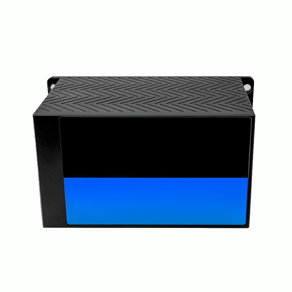
LS Lidar HS1 100m Fast Scanning Traffic LiDAR
Get the best price for your setup
Contact our experts for the best possible price and configuration.
- Fast response
- Expert configuration advice
- No overpaying for features you do not need
The LS Lidar HS1 is a fast-scanning single-channel 2D LiDAR designed for vehicle measurement, traffic monitoring, industrial detection and high-speed object profiling. Its 120° field of view, detection range of up to 100 m at 10% reflectivity and scanning frequency of up to 160 Hz allow the sensor to capture moving vehicles and objects with rapid updates. With ±3 cm ranging accuracy, 53,000 points per second and Ethernet communication, the HS1 is well suited to ETC systems, vehicle contour measurement, height detection and intelligent transport installations.
LS Lidar HS1 Highlights
| LiDAR type | Single-channel fast-scanning 2D LiDAR |
|---|---|
| Detection range | Up to 100 m at 10% reflectivity |
| Range accuracy | ±3 cm |
| Field of view | 120° |
| Scanning frequency | 40 to 160 Hz |
| Point rate | 53,000 points/sec |
| Protection | IP67 |
Valued customers:










Find RTK Networks
Search NTRIP providers and connect to reliable RTK correction services.
Description
Fast Scanning LiDAR for Vehicle and Traffic Detection
The LS Lidar HS1 is a high-speed single-channel LiDAR developed for intelligent transportation, vehicle measurement and industrial detection applications. Rather than producing a full 3D point cloud, the HS1 scans across a single 120° plane at high speed, making it particularly effective for measuring vehicle contours, detecting moving objects and monitoring traffic lanes.
Its combination of fast scanning, centimetre-level ranging and Ethernet communication makes the HS1 suitable for fixed roadside installations, toll systems, vehicle classification points, loading facilities and other locations where objects need to be measured reliably while moving through a defined detection area.
Up to 100 Metres at 10% Reflectivity
The HS1 is specified for detection at up to 100 metres on targets with 10% reflectivity. Reflectivity is an important part of LiDAR range specifications because dark surfaces return considerably less laser energy than bright or reflective objects.
For vehicle detection, this provides a useful reference because tyres, dark vehicle bodies and cargo can be more difficult to detect than light-coloured surfaces. Actual operating range will depend on target material, environmental conditions, installation angle and the surrounding environment.
High Speed Scanning up to 160 Hz
The HS1 supports scanning frequencies from 40 to 160 Hz. At the highest setting, the sensor updates its measurement plane 160 times per second, giving detection software frequent information about vehicles or other objects passing through the scanning area.
This fast update rate is especially useful on roads, toll lanes and industrial entrances where objects may be moving quickly. More frequent measurements help capture the shape and position of a vehicle as it passes the sensor, rather than relying on only a small number of measurement frames.
Designed for Vehicle Contour Measurement
One of the main applications of the HS1 is measuring the outline of vehicles and cargo. When installed above or beside a traffic lane, the LiDAR can scan across a passing vehicle and provide distance measurements that software can use to calculate its profile.
This type of data can support vehicle dimension measurement, oversize detection, height-control systems and vehicle classification. It can also be used at logistics sites where trucks and loads need to be monitored as they enter or leave a facility.
120 Degree Field of View
The HS1 provides a 120° scanning field of view. This broad horizontal measurement area allows the sensor to cover a traffic lane or industrial detection zone without requiring mechanical 360° scanning.
For a fixed installation, the LiDAR can therefore be positioned so that the measurement plane intersects the area where a vehicle or object is expected to pass. Correct mounting position and angle are important because the HS1 measures within one scanning plane rather than producing a multi-layer 3D image.
±3 cm Ranging Accuracy
The current technical specification for the HS1 states a ±3 cm ranging accuracy. This is suitable for vehicle profiling, object position detection and traffic applications where reliable centimetre-level distance measurements are required.
For dimensional measurement systems, the final result will also depend on installation geometry, calibration, mounting stability and the processing software used to convert the LiDAR measurements into vehicle dimensions or classifications.
53000 Measurement Points per Second
The HS1 outputs approximately 53,000 measurement points per second. Because these points are concentrated into one scanning plane, the sensor can capture useful contour detail without producing the much larger datasets associated with multi-channel 3D LiDAR.
This makes the HS1 practical for embedded traffic and industrial systems where fast object detection is required but a complete three-dimensional representation of the environment is unnecessary.
Adjustable Angular Resolution
Angular resolution changes with the selected scanning frequency. At 40 Hz, the specified horizontal resolution is approximately 0.09°, increasing to approximately 0.36° at 160 Hz. This allows system designers to balance scan speed against measurement density.
Lower scan frequencies provide more closely spaced measurements across each scan, while higher frequencies provide faster updates. The appropriate setting therefore depends on vehicle speed, required contour detail and the processing requirements of the installation.
905 nm Time of Flight Measurement
The HS1 uses a 905 nm Class 1 laser and Time of Flight measurement technology. The sensor emits laser pulses, detects their reflections and calculates distance from the time required for the light to return.
This allows the LiDAR to measure vehicle and object positions independently of normal visible lighting conditions. Like all optical sensors, performance can still be influenced by heavy precipitation, contamination of the optical window and environmental conditions.
Ethernet Integration
The HS1 communicates through Ethernet, allowing measurement data to be transferred directly to an industrial computer, traffic controller or other processing system. This makes it suitable for permanent installations where the LiDAR forms one component of a larger detection or classification system.
The sensor operates from a broad 9 to 36 VDC supply range, which provides flexibility when integrating it into roadside equipment, vehicle systems or industrial control cabinets.
Built for Outdoor Installations
The HS1 has an IP67 protection rating and is designed to withstand vibration and mechanical shock. LS Lidar specifies dimensions of approximately 155 × 107.5 × 90 mm, making the unit compact enough for mounting on roadside structures, gantries and industrial equipment.
The current manufacturer page specifies an operating temperature range of approximately -20°C to +65°C. Environmental protection and secure mounting are important in traffic applications because the sensor may be exposed continuously to vibration, dust, water and changing weather conditions.
Typical HS1 Applications
- Vehicle and cargo contour measurement
- Height and oversize detection
- Highway ETC trigger and detection systems
- Vehicle type classification
- Traffic flow monitoring
- Industrial entrance and exit monitoring
- High-speed moving object detection
Why Use a Single Channel LiDAR?
A single-channel sensor such as the HS1 is useful when the application needs a precise cross-section of an object rather than a full 3D model. By concentrating its measurements into one plane, it can scan quickly and produce a relatively manageable data stream.
This is well suited to vehicle profiling because the vehicle itself moves through the measurement plane. As successive scans are collected, software can reconstruct information about its contour, dimensions or classification. Applications that require full spatial awareness in several directions at the same time are generally better served by a multi-channel 3D LiDAR.
Buying the LS Lidar HS1 from Global GPS Systems
Global GPS Systems supplies LiDAR, GNSS and professional measurement equipment for transportation, construction, surveying and industrial applications worldwide. Our team can help determine whether the HS1 provides the correct scan speed, detection range and measurement geometry for your project.
For vehicle measurement and traffic projects, sensor placement is just as important as the LiDAR specification itself. Global GPS Systems can help evaluate the intended installation, required measurement area and supporting equipment so the selected sensor matches the practical field application.
Datasheets & Manuals
Specifications
LSLiDAR HS1 Fast Scanning LiDAR Specifications
Product Overview
| Product name | LSLiDAR HS1 |
|---|---|
| Product series | HS Series |
| Product type | High-speed single-line LiDAR |
| Scanning channels | 1 |
| Measurement principle | Time of Flight (ToF) |
| Primary purpose | High-speed object profiling, vehicle contour detection and non-contact dimensional measurement |
| Primary applications | Vehicle and cargo dimension measurement, vehicle classification, height-limit detection, oversize detection, high-speed ETC triggering, entry/exit vehicle detection and traffic-flow analysis |
| Typical operating scenario | Roadside and industrial detection of rapidly moving objects |
Laser and Measurement Specifications
| Laser wavelength | 905 nm |
|---|---|
| Laser classification | Class 1, eye-safe |
| Laser safety standard | IEC 60825 Class 1 according to manufacturer product documentation |
| Detection method | ToF (Time of Flight) |
| Current published range | 100 m at 10% target reflectivity on the current LSLiDAR product page |
| Published range configurations | 30 m / 50 m / 70 m / 100 m at 10% reflectivity are listed in current-generation manufacturer brochure material |
| Current key-specification accuracy | ±3 cm |
| Alternative published accuracy | ±2 cm in LSLiDAR product overview material and the Global GPS Systems product description |
| Data acquisition rate | 53,000 points/second |
Field of View
| Horizontal field of view | 120° |
|---|---|
| Vertical field of view | Single-line scanning; no multi-line vertical FOV specification |
| Scan geometry | Single horizontal scan line across a 120° sector |
Scanning Frequency and Angular Resolution
| Scanning Frequency | Horizontal Angular Resolution |
|---|---|
| 40 Hz | 0.09° |
| 80 Hz | 0.18° |
| 100 Hz | 0.225° in current manufacturer product-page specifications |
| 120 Hz | 0.27° |
| 160 Hz | 0.36° |
| 200 Hz | 0.45° in LSLiDAR HS Series product-introduction documentation |
Scanning Performance
| Current key-specification scan rate | 40–160 Hz |
|---|---|
| Maximum scan rate in HS Series product documentation | 200 Hz |
| Published selectable rates | 40 Hz, 80 Hz, 100 Hz, 120 Hz and 160 Hz depending on documentation / hardware revision |
| 200 Hz mode | Documented in HS Series product-introduction material and the Global GPS Systems product description |
| Maximum point rate | 53,000 points/second |
| High-speed object sensing | Designed to capture rapidly moving objects and vehicle contours in real time |
| Documented vehicle-speed example | Manufacturer documentation illustrates vehicle profiling at approximately 120 km/h |
Range Configuration
| Published Source / Configuration | Detection Range | Target Reflectivity |
|---|---|---|
| Current LSLiDAR product page | 100 m | 10% |
| Recent manufacturer product brochure | 30 / 50 / 70 / 100 m configurations | 10% |
| Global GPS Systems linked HS1 datasheet | 30 m | 10% |
Communication Interface
| Communication interface | Ethernet / Industrial Ethernet |
|---|---|
| Primary output | Real-time LiDAR distance / scan data for integration into host detection systems |
| System integration | Designed for connection to vehicle-measurement, traffic-monitoring and industrial detection systems |
Electrical Specifications
| Input voltage | 9–36 VDC |
|---|---|
| Power interface | DC-powered sensor architecture for fixed roadside or equipment integration |
| Power consumption | Not specified in the reviewed HS1 manufacturer specification tables |
Environmental Specifications
| Ingress protection | IP67 |
|---|---|
| Current manufacturer operating temperature | -20°C to +65°C |
| Global GPS Systems linked datasheet operating temperature | -40°C to +65°C |
| Vibration resistance | 5 Hz–2000 Hz, 3 g RMS |
| Shock resistance | 500 m/s² for 11 ms |
| Approximate shock acceleration | Approximately 51 g |
| Outdoor operation | Weather-protected design suitable for applicable roadside and industrial installations |
| Strong-light resistance | Designed with anti-glare / anti-interference capability for outdoor detection |
| LiDAR interference resistance | Manufacturer identifies anti-interference performance as a key HS Series design feature |
Physical Specifications
| Length | 155 mm |
|---|---|
| Width | 107.5 mm |
| Height | 90 mm |
| Overall dimensions | 155 × 107.5 × 90 mm |
| Weight | 1600 g |
| Form factor | Compact fixed-mount industrial LiDAR enclosure |
Vehicle and Cargo Measurement
| Vehicle contour detection | Supported application |
|---|---|
| Cargo contour detection | Supported application |
| Vehicle length measurement | Supported as part of compatible multi-sensor vehicle-measurement systems |
| Vehicle width measurement | Supported as part of compatible multi-sensor vehicle-measurement systems |
| Vehicle height measurement | Supported as part of compatible vehicle-measurement systems |
| Drive-through measurement | LSLiDAR vehicle-measurement systems are designed to measure vehicles without requiring them to stop |
| Multi-lane applications | Applicable LSLiDAR HS Series systems can be configured for single- and multi-lane detection |
| Camera triggering | HS Series systems can be integrated into applications that trigger vehicle image capture |
Intelligent Transportation Applications
| Application | Typical HS1 Function |
|---|---|
| Vehicle dimension measurement | High-speed vehicle contour acquisition for length, width and height measurement systems |
| Cargo dimension measurement | Profile acquisition for vehicle and load-envelope measurement |
| Vehicle classification | Contour information can be used to distinguish vehicle classes |
| Height-limit monitoring | Detects vehicle profiles for over-height monitoring |
| Oversize detection | Supports dimensional screening of oversized vehicles and loads |
| Highway ETC activation | Fast object detection for compatible electronic toll collection trigger systems |
| Entry / exit monitoring | Vehicle presence and classification at controlled access points |
| Traffic flow statistics | Vehicle detection and counting |
| Traffic congestion analysis | Vehicle-flow information can be used by compatible traffic-monitoring systems |
Performance Features
| High scanning speed | Up to 200 Hz in applicable HS1 documentation |
|---|---|
| High-speed target capture | Designed for moving-vehicle profiling |
| High-density acquisition | 53,000 points/second |
| Anti-vibration design | Specified vibration endurance of 5–2000 Hz at 3 g RMS |
| Impact resistance | Specified shock resistance of 500 m/s² for 11 ms |
| Anti-interference design | Supported |
| Anti-glare design | Supported |
HS1 and MS-HS1 Distinction
| Specification | HS1 | MS-HS1 Mapping LiDAR |
|---|---|---|
| Primary application | Fast vehicle / object profiling and ITS detection | High-speed mapping and surveying |
| Channels | 1 | 1 |
| Laser wavelength | 905 nm | 905 nm |
| Published range | Up to 100 m at 10% reflectivity depending on HS1 configuration | 250 m |
| Point rate | 53,000 pts/s | 200,000 pts/s single echo / 400,000 pts/s dual echo |
| Product relationship | Product listed on the supplied Global GPS Systems URL | Separate mapping-oriented LSLiDAR model and should not be treated as the same specification |
Published Specification Differences
| Specification | Current LSLiDAR Product Page / Key Specs | HS Series Product Introduction | Global GPS Systems Linked Datasheet |
|---|---|---|---|
| Detection range | 100 m at 10% | 100 m | 30 m at 10% |
| Range accuracy | ±3 cm in the key-specification table; page overview also states ±2 cm | ±2 cm | ±3 cm |
| Maximum scanning frequency | 160 Hz in the key-specification table; product overview states up to 200 Hz | 200 Hz | 160 Hz |
| Point rate | 53,000 pts/s | 53,000 pts/s | 53,000 pts/s |
| Horizontal FOV | 120° | 120° | 120° |
| Operating voltage | 9–36 VDC | 9–36 VDC | 9–36 VDC |
| Operating temperature | -20°C to +65°C | -20°C to +65°C | -40°C to +65°C |
| Ingress protection | IP67 | IP67 | IP67 |
| Dimensions | 155 × 107.5 × 90 mm | 155 × 107.5 × 90 mm | 155 × 107.5 × 90 mm |
| Weight | Not displayed in the current web key-specification block | 1600 g | 1600 g |
Configuration Notes
| Range versions | LSLiDAR documentation indicates multiple HS1 range configurations including 30 m, 50 m, 70 m and 100 m at 10% reflectivity |
|---|---|
| Accuracy variation | Manufacturer documents contain both ±2 cm and ±3 cm values; the exact production configuration should be confirmed where dimensional accuracy is critical |
| Scanning-frequency variation | Some documents specify a maximum of 160 Hz while product overview material specifies operation up to 200 Hz |
| Temperature variation | The current manufacturer page specifies -20°C to +65°C, while the Global GPS Systems linked datasheet specifies -40°C to +65°C |
| Model identification | HS1 Fast Scanning LiDAR should not be confused with the separate MS-HS1 high-speed mapping LiDAR, which has different range, point-rate and echo specifications |
Specifications and package contents may vary by configuration, region or manufacturer update. Always check the current configuration before ordering.
Reviews (0)
Only logged in customers who have purchased this product may leave a review.
FAQ
LS LiDAR HS1 FAQ
HS1 LiDAR & Applications
What is the LS LiDAR HS1?
The LS LiDAR HS1 is a high-speed single-channel LiDAR sensor designed for rapid 2D distance scanning and object profiling. It combines a 120-degree horizontal field of view, detection distances up to approximately 100 metres, centimetre-level ranging accuracy and scanning frequencies up to 200 Hz, making it particularly suitable for intelligent transportation and high-speed object detection.
Is the LS LiDAR HS1 a 2D or 3D LiDAR?
The HS1 is a single-channel 2D LiDAR. It scans across a 120-degree horizontal field of view to create a profile of objects passing through the scan plane. It does not independently produce a full 3D point cloud like a multi-channel 3D LiDAR, although 3D information can be created when the sensor is combined with movement or another positioning mechanism.
What is the LS LiDAR HS1 designed for?
The HS1 is primarily designed for intelligent transportation and high-speed measurement applications. Typical uses include vehicle contour measurement, cargo dimension detection, vehicle classification, height-limit monitoring, oversize detection, highway ETC triggering and traffic-flow analysis.
Can the HS1 measure vehicles travelling at highway speeds?
Yes. High-speed vehicle measurement is one of the main applications of the HS1. LS LiDAR states that its fast scanning technology can model vehicles travelling at approximately 120 km/h, allowing the sensor to capture detailed vehicle contour information while traffic remains in motion.
Can the HS1 be used for vehicle and cargo dimension measurement?
Yes. The HS1 can rapidly scan the profile of a passing vehicle or load. When measurements from the LiDAR are combined with suitable processing software and installation geometry, the data can be used to determine vehicle height, width, contour and other dimensional information.
Can the HS1 identify different vehicle types?
Yes. The high-speed profile data generated by the HS1 can be used by compatible classification software to distinguish vehicle shapes and categories. Applications include vehicle-type classification at entrances and exits, highway monitoring, tolling systems and traffic-analysis installations.
Range, Accuracy & Scanning Performance
What is the detection range of the LS LiDAR HS1?
The HS1 has a specified detection range of approximately 100 metres on a target with 10% reflectivity. Actual detection range can vary with target reflectivity, size, angle, atmospheric conditions, contamination of the optical window and the installation environment.
How accurate is the LS LiDAR HS1?
LS LiDAR documentation specifies centimetre-level ranging accuracy for the HS1, with product literature listing approximately ±2 cm under suitable conditions. Some current specification listings state ±3 cm, so the exact accuracy specification should be confirmed for the supplied HS1 hardware revision.
What is the field of view of the HS1?
The HS1 provides a 120-degree horizontal field of view. Because it is a single-channel scanner, the measurements form a horizontal scan profile rather than the broad vertical field produced by a multi-channel 3D LiDAR.
How fast can the LS LiDAR HS1 scan?
The HS1 supports very high scanning frequencies, with manufacturer documentation listing modes up to 200 Hz. This high scan rate is designed to capture rapidly moving objects such as vehicles without requiring them to stop or significantly reduce speed.
What scanning frequencies are available on the HS1?
Manufacturer documentation lists scanning modes including 40 Hz, 80 Hz, 120 Hz, 160 Hz and up to 200 Hz. The selected scanning frequency affects how quickly the scene is refreshed and the horizontal angular spacing between measurements.
What is the angular resolution of the LS LiDAR HS1?
The horizontal angular resolution varies with the selected scanning frequency. Manufacturer documentation lists approximately 0.09 degrees at 40 Hz, 0.18 degrees at 80 Hz, 0.27 degrees at 120 Hz, 0.36 degrees at 160 Hz and 0.45 degrees at 200 Hz.
How many points per second does the HS1 generate?
The LS LiDAR HS1 generates approximately 53,000 measurement points per second. This high data rate allows detailed profiles of moving vehicles and other objects to be captured for dimensional measurement, classification and detection systems.
Laser, Communication & System Integration
How does the LS LiDAR HS1 measure distance?
The HS1 uses Time of Flight technology. It transmits laser pulses toward a target and measures the time required for reflected light to return to the sensor. These measurements are combined with the scan angle to determine the distance and profile of objects within the field of view.
What laser wavelength does the HS1 use?
The LS LiDAR HS1 uses a 905 nm near-infrared laser. This wavelength is widely used in industrial and intelligent-transportation Time of Flight LiDAR systems.
Is the LS LiDAR HS1 eye-safe?
Yes. Manufacturer documentation specifies the HS1 as a Class 1 laser product according to IEC 60825 requirements. The sensor should nevertheless be installed, operated and maintained according to the manufacturer's laser-safety instructions.
How does the HS1 connect to a computer or control system?
The HS1 uses an industrial Ethernet interface for transferring LiDAR measurement data to an external computer or controller. This allows the sensor to be integrated with traffic-management systems, industrial computers, dimension-measurement platforms and custom detection software.
Can the LS LiDAR HS1 be integrated into a custom system?
Yes. The HS1 is designed as an integration component rather than a complete standalone traffic-analysis system. Its Ethernet output can supply real-time ranging and scan data to custom software for applications such as vehicle classification, dimension measurement, traffic counting, access control and oversize detection.
Is the HS1 resistant to interference and strong sunlight?
Yes. LS LiDAR describes the HS1 as having anti-interference and anti-glare capabilities intended to support reliable outdoor operation. Actual performance can still be influenced by environmental conditions, installation angle, reflective surfaces and contamination of the optical window.
Power, Durability & Installation
What power supply does the LS LiDAR HS1 require?
The HS1 supports a 9 to 36 VDC input supply. This wide voltage range makes it suitable for integration into roadside systems, vehicles and industrial installations with compatible DC power systems.
Is the LS LiDAR HS1 waterproof and dustproof?
Yes. The HS1 has an IP67 environmental protection rating. This provides protection against dust and temporary water immersion when the sensor and its connections are correctly installed according to the manufacturer's requirements.
What temperature range can the HS1 operate in?
The specified operating temperature range of the HS1 is approximately -20°C to +65°C. This makes the sensor suitable for a wide range of outdoor traffic-monitoring and industrial installations.
Is the LS LiDAR HS1 resistant to shock and vibration?
Yes. The HS1 is designed for demanding transportation and industrial applications. Manufacturer specifications include vibration testing from approximately 5 Hz to 2000 Hz at 3G RMS and shock testing of 500 m/s² for 11 ms.
How large and heavy is the LS LiDAR HS1?
The HS1 measures approximately 155 × 107.5 × 90 mm and weighs approximately 1.6 kg. Its fixed housing is suitable for installation on roadside structures, gantries, tolling systems and other permanent measurement platforms.
What should be considered when installing the HS1?
The HS1 should be mounted rigidly with an unobstructed 120-degree scanning area and positioned so that the scan plane intersects the objects that need to be measured. The optical window should be kept clean, and the mounting height and angle should be accurately determined when the system is being used for vehicle dimensions, height detection or other quantitative measurements.

 GPS & GNSS
 Total Stations
 Data collectors
 Software
 Correction services
 Machine control
 External radio
 Marine
 Accessories
Reviews
There are no reviews yet