

 GPS & GNSS
 Lidar scanning
 Total Station
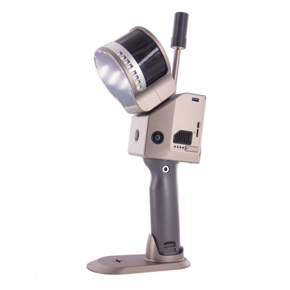
Geosun GS 100G 120m Handheld SLAM LiDAR Scanner
Get the best price for your setup
Contact our experts for the best possible price and configuration.
- Fast response
- Expert configuration advice
- No overpaying for features you do not need
The Geosun GS-100G is a portable handheld SLAM LiDAR scanner for fast 3D mapping indoors, outdoors and in areas where GNSS reception is limited or unavailable. It combines a 16-channel LiDAR sensor with GNSS, INS and SLAM positioning to create georeferenced point clouds while the operator walks through the survey area. With a maximum measuring range of 120 m, up to 640,000 points per second and absolute point-cloud accuracy of up to 5 cm, the GS-100G is well suited to building surveys, construction documentation, mines, tunnels, stockpile measurement, topographic mapping and other mobile 3D data collection tasks.
Geosun GS-100G Highlights
| LiDAR range | Up to 120 m |
|---|---|
| Point-cloud accuracy | ≤5 cm absolute accuracy |
| Laser channels | 16-channel LiDAR |
| Point rate | Up to 640,000 points/sec |
| Field of view | 270° vertical × 360° horizontal |
| Camera | Integrated 3 × 5 MP cameras |
| Mapping modes | SLAM, RTK-SLAM and PPK-SLAM |
| Battery runtime | Up to 2 hours |
You may also like…
Lidar & 3D scanning
Valued customers:










Find RTK Networks
Search NTRIP providers and connect to reliable RTK correction services.
Description
Portable SLAM LiDAR for indoor and outdoor 3D mapping
The Geosun GS-100G is a handheld mobile LiDAR scanning system developed for surveyors, construction professionals, engineers, GIS teams, mine operators and other users who need to capture detailed 3D information quickly while moving through a site. Instead of measuring individual points from a tripod, the operator can walk through the survey area while the GS-100G continuously records the surrounding geometry and builds a point cloud.
The system combines LiDAR, GNSS, inertial positioning and SLAM algorithms in one portable unit. This allows it to work both outdoors where satellite positioning is available and indoors, underground or around structures where GNSS signals can become unreliable or disappear completely.
120 metre LiDAR range
The GS-100G provides a maximum measuring range of approximately 120 m, with the manufacturer specifying around 80 m range at 10% target reflectivity. This makes the scanner suitable for rooms and buildings as well as larger industrial spaces, tunnels, underground workings, stockpiles and outdoor terrain.
A longer working range is useful when surveying large structures or open spaces because the operator can capture surfaces from farther away instead of having to walk close to every object. Actual usable range depends on surface reflectivity, lighting, geometry and environmental conditions.
Up to 640,000 points per second
The 16-channel LiDAR sensor can record up to 640,000 points per second in dual-echo operation. This high acquisition rate allows the GS-100G to build dense three-dimensional representations of walls, floors, terrain, machinery, stockpiles and other objects while the operator is moving.
In practical surveying work, denser point clouds provide more geometric information for modelling and measurement. The required level of detail still depends on walking speed, distance from the object and the way the survey route is planned.
SLAM mapping without permanent GNSS reception
One of the main advantages of the GS-100G is its use of SLAM technology. SLAM stands for Simultaneous Localization and Mapping. As the scanner moves, the system compares surrounding geometry between successive scans to estimate its movement while simultaneously building the map.
This means the scanner can continue operating inside buildings, tunnels, underground garages and mines where a conventional GNSS rover cannot maintain a satellite position. For construction and engineering teams, this provides a practical way to capture complete interiors and enclosed environments without setting up a scanner at many individual tripod positions.
SLAM RTK-SLAM and PPK-SLAM workflows
The GS-100G supports SLAM, RTK-SLAM and PPK-SLAM mapping methods. Pure SLAM is useful for enclosed environments where satellite signals are unavailable. RTK-SLAM can use real-time GNSS positioning where correction data is available, while PPK-SLAM allows GNSS trajectory information to be processed after data collection.
For mixed indoor and outdoor projects, this flexibility is especially useful. A surveyor can move from an open environment into a building or tunnel while using the positioning method appropriate to each part of the project.
Integrated GNSS and inertial positioning
The GS-100G integrates GNSS and inertial positioning alongside its SLAM engine. The published configuration uses Geosun’s gSpin positioning technology with a 200 Hz update rate and support for GPS, GLONASS, BeiDou and Galileo satellite signals.
The inertial sensors measure the movement and orientation of the scanner between GNSS updates. Together with SLAM, this helps maintain a continuous trajectory as the operator walks through the survey environment.
Wide field of view for complete surroundings
The LiDAR scanner provides approximately 360° horizontal and 270° vertical coverage. This wide field of view allows the GS-100G to capture surfaces around, above and below the operator while moving through the site.
For indoor surveys this helps record walls, ceilings, floors, structural elements and installations in a single walking workflow. In tunnels and underground environments it allows the scanner to capture most of the surrounding profile without continuously aiming the instrument manually.
Integrated cameras for colour and visual context
The current GS-100G configuration includes three integrated 5 MP cameras. The images provide visual information that can be combined with the geometric LiDAR data to make the resulting point cloud easier to interpret.
Colour information can be particularly useful when inspecting buildings, utilities or industrial environments because it helps users recognise materials, markings and physical features that may be difficult to distinguish from geometry alone.
Useful for construction and building surveys
On construction sites, the GS-100G can be used to document existing conditions, capture building interiors and record completed work. Because scanning takes place while walking, large areas can be documented quickly compared with workflows that require many separate static scanner positions.
The resulting point cloud can provide a spatial record for engineering, renovation, BIM-related workflows, dimensional checks and progress documentation. The suitability of the data for any particular tolerance should always be checked against the accuracy requirements of the project.
Underground mines tunnels and GNSS-denied environments
The GS-100G is particularly well suited to environments where satellite positioning cannot be relied on. Geosun has used the system for underground mine development, tunnel scanning and indoor coal-stockpile surveys.
In these environments, operators can walk through passages and enclosed spaces while SLAM maintains the scanner trajectory. This reduces the dependence on permanent GNSS reception and can make data collection considerably more practical in narrow or difficult-to-access locations.
Stockpile and volume measurement
LiDAR point clouds can also be used to model stockpiles, excavations and bulk materials. Once the surfaces are captured and processed, compatible software can be used to calculate volumes or compare surveys from different dates.
This is useful for mining, quarrying, earthworks, recycling facilities and construction projects where regular volume measurements are required and walking around the site with conventional survey equipment would take considerably longer.
Topographic and infrastructure mapping
Although the GS-100G is primarily designed as a handheld scanner, its integrated GNSS and SLAM capabilities also make it useful for outdoor mapping. Typical applications include topographic surveys, infrastructure documentation, power-line environments and general spatial data acquisition.
For outdoor work, GNSS information can provide a geographic reference while SLAM maintains detailed local mapping. The combination is especially useful when the survey route repeatedly moves between open areas and locations partly obstructed by buildings, vegetation or infrastructure.
Portable design for fieldwork
The GS-100G is designed to be carried by one operator and can also be used in backpack-style configurations. Current Geosun technical information lists the complete system at approximately 2.2 kg, with around 2 hours of battery operation, 128 GB internal storage and an operating temperature range from approximately -20°C to +55°C.
This portability makes the system suitable for surveys where carrying a larger terrestrial laser scanner, tripod and multiple accessories would be inconvenient.
Point-cloud processing workflow
After scanning, the recorded trajectory, LiDAR measurements and image data are processed into a usable three-dimensional point cloud. Geosun provides Point Cloud Creater software for point-cloud preprocessing, while the resulting data can then be taken into compatible CAD, GIS, BIM, engineering, mining or specialist point-cloud software depending on the required deliverables.
Careful survey planning remains important with any SLAM system. Walking loops, maintaining sufficient overlap between scanned areas and revisiting previously mapped geometry can help the SLAM algorithm maintain a consistent trajectory, especially in long corridors or environments containing repetitive features.
Who is the Geosun GS-100G for?
The GS-100G is a practical option for surveyors, construction companies, BIM teams, engineers, mining professionals, GIS users and mobile-mapping specialists who need a faster way to document complex environments in three dimensions. It is particularly useful for projects that combine indoor and outdoor areas or where GNSS reception cannot be maintained throughout the complete survey.
Buying the Geosun GS-100G from Global GPS Systems
Selecting a SLAM scanner should be based on the required accuracy, site size, working environment, final deliverables and processing workflow. Global GPS Systems can help determine whether the Geosun GS-100G fits your project and advise on the appropriate surveying workflow, GNSS setup and point-cloud processing requirements for your application.
Datasheets & Manuals
Specifications
GeoSun GS-100G Handheld SLAM LiDAR Scanning System Specifications
Product Overview
| Product name | GeoSun GS-100G |
|---|---|
| Product family | GeoSun gFireEye Series |
| Product type | Handheld SLAM LiDAR scanning and mobile mapping system |
| Mapping architecture | Integrated LiDAR, GNSS, INS/POS, SLAM processing and RGB mapping cameras |
| Documented LiDAR configuration | 16-channel Hesai XT16-based configuration |
| POS unit | GeoSun gSpin 210 |
| Mapping modes | Pure SLAM, RTK-SLAM and PPK-SLAM |
| Indoor / outdoor operation | Designed for seamless mapping between GNSS-available outdoor areas and GNSS-denied indoor or underground environments |
| Primary carrying platforms | Handheld, multi-rotor UAV and vehicle |
| Typical applications | Building surveys, BIM, construction, underground mapping, tunnels, mineshafts, forestry, municipal infrastructure, power-line inspection, industrial facilities, heritage documentation, stockpile surveying and digital twins |
System Accuracy and Performance
| Published point-cloud accuracy | 5 cm at 100 m without control points |
|---|---|
| LiDAR range accuracy | ±1.5 cm in the GS-100G datasheet and principal manufacturer specification |
| Alternative published range accuracy | 1 cm appears in a later GeoSun GS-100G product listing; verify the supplied hardware revision when range accuracy is critical |
| Maximum LiDAR range | 120 m |
| Range at 10% reflectivity | 80 m |
| Maximum point rate | 640,000 points/second in dual-echo mode |
| Single-echo point rate | 320,000 points/second |
| SLAM operation | Real-time acquisition combined with post-processing for high-resolution 3D point-cloud generation |
LiDAR Scanner Specifications
| LiDAR sensor | Hesai XT16 on the documented GS-100G configuration |
|---|---|
| Number of channels | 16 |
| Maximum detection range | 120 m |
| Detection range at 10% reflectivity | 80 m |
| Range accuracy | ±1.5 cm |
| Horizontal field of view | 360° |
| Vertical field of view | 270° system scanning coverage as specified by GeoSun |
| Echo modes | Single echo and dual echo |
| Single-echo point rate | 320,000 points/second |
| Dual-echo point rate | 640,000 points/second |
| 3D point-cloud output | Supported |
Echo and Vegetation Performance
| Single return | Supported |
|---|---|
| Dual return | Supported |
| Maximum dual-return data rate | 640,000 points/second |
| Vegetation surveying | Multi-return acquisition supports forestry and vegetation mapping workflows |
| Ground-surface mapping | Suitable for collecting terrain returns in areas where laser pulses can penetrate vegetation openings |
GNSS / INS Position and Orientation System
| POS model | gSpin 210 |
|---|---|
| POS update frequency | 200 Hz |
| Horizontal position accuracy | 0.02 m |
| Vertical position accuracy | 0.03 m |
| Pitch accuracy | 0.015° |
| Roll accuracy | 0.015° |
| Heading accuracy | 0.040° |
| GNSS integration | Integrated multi-constellation GNSS receiver |
| GNSS / INS function | Provides position and orientation information for georeferencing LiDAR and camera data |
GNSS Signal Support
| GPS | L1 / L2 / L5 |
|---|---|
| GLONASS | L1 / L2 |
| BeiDou | B1C / B1 / B2 / B2a / B2b / B3 |
| Galileo | E1 / E5a / E5b |
| RTK-SLAM | Supported |
| PPK-SLAM | Supported |
| Pure SLAM | Supported for GNSS-denied environments |
Mapping Modes
| Mode | Positioning Method | Typical Use |
|---|---|---|
| Pure SLAM | LiDAR / INS SLAM without external GNSS positioning | Indoor areas, tunnels, mines, underground spaces and other GNSS-denied environments |
| RTK-SLAM | Real-time GNSS positioning combined with SLAM | Georeferenced outdoor and indoor/outdoor transition mapping |
| PPK-SLAM | Post-processed GNSS positioning combined with SLAM | Survey workflows requiring post-processed georeferencing |
RGB Mapping Camera
| Camera integration | Built-in panoramic RGB camera system |
|---|---|
| Global GPS Systems configuration | 3 × 5 MP cameras |
| Total nominal camera resolution | 15 MP across three 5 MP imaging modules |
| Horizontal camera FOV | 270° |
| Shooting mode | Isochronous / synchronized acquisition |
| Color point cloud | Supported |
| Camera synchronization | Camera imagery is synchronized with LiDAR / trajectory data for point-cloud colorization |
Camera Revision Differences
| Original / Global GPS Systems configuration | 3 × 5 MP panoramic camera system |
|---|---|
| Later GeoSun GS-100G documentation | Some later production documentation lists 2 × 20 MP cameras with 270° horizontal coverage |
| Latest regional GS-100G listings | Some current regional GeoSun listings also reference 2 × 20 MP RGB imaging and alternative XT16 / XT32 sensor configurations |
| Configuration note | The Global GPS Systems product package reviewed specifies the 3 × 5 MP camera configuration; confirm the imaging configuration of the exact supplied unit |
Storage
| Original documented internal storage | 64 GB built-in flash memory |
|---|---|
| Removable storage | microSD / TF card |
| Maximum supported removable storage | Up to 256 GB in manufacturer documentation |
| Global GPS Systems supplied card | 64 GB microSD card |
| Later GS-100G hardware | Some later manufacturer listings specify 128 GB built-in flash memory with support for microSD up to 256 GB |
Electrical and Power Specifications
| Input voltage range | 12–18 VDC |
|---|---|
| Published system power consumption | 25 W in the GS-100G datasheet |
| Alternative manufacturer power figure | 20 W appears on another official GeoSun GS-100G product specification page |
| Original battery specification | 4.2 V, 3400 mAh |
| Global GPS Systems battery package | 4.2 V, 3400 mAh battery set |
| Later battery configuration | Some later GeoSun GS-100G documentation specifies an 11,600 mAh battery system |
| External platform power | Supported for compatible UAV and vehicle installations within the specified supply range |
Physical Specifications
| Original datasheet dimensions | 153 × 93 × 394 mm |
|---|---|
| Original weight | 1.7 kg without battery |
| Global GPS Systems listed weight | 1.7 kg without battery |
| Later published weight | Approximately 2.15 kg with battery |
| Later published dimensions | Approximately 172 × 106 × 389 mm in some GeoSun listings |
| Housing material | Aluminum-alloy body in later manufacturer product documentation |
| Form factor | Portable handheld scanner with integrated LiDAR head, electronics, camera system and handle |
Environmental Specifications
| Operating temperature | -20°C to +55°C |
|---|---|
| Ingress protection | No model-specific IP rating is stated in the reviewed GS-100G datasheet |
| Indoor use | Supported |
| Outdoor use | Supported within the specified environmental limits |
| Underground operation | Supported using SLAM in GNSS-denied environments |
Platform Compatibility
| Platform | Support | Typical Use |
|---|---|---|
| Handheld | Supported | Buildings, construction, tunnels, forestry, industrial sites and heritage mapping |
| Multi-rotor UAV | Supported by manufacturer documentation | Low-altitude LiDAR mapping where payload and mounting requirements are compatible |
| Vehicle | Supported | Mobile mapping and corridor data acquisition |
| Backpack | Accessory / configuration-dependent | Extended walking surveys and hands-free mobile mapping |
PointCreater / PointCloudCreater Software
| Software | GeoSun PointCreater / PointCloudCreater |
|---|---|
| Global GPS Systems package | LiDAR processing software included |
| Trajectory processing | Integrated with GeoSun trajectory calculation workflows |
| Raw LiDAR processing | Supported |
| GNSS / INS processing | Supports processing of base-station GNSS, rover GNSS and IMU data in compatible workflows |
| Automatic hardware recognition | Supported by current PointCloudCreater software |
| One-key processing | Supported |
| Coordinate transformation | Supported |
| True-color point cloud | Supported |
| Strip adjustment | Supported |
| Point-cloud optimization | Supported |
| Distance filtering | Supported |
| Angle filtering | Supported |
| Range filtering | Supported |
| Laser-line filtering | Supported |
| LAS output | Supported |
| Colorized PT output | Supported in applicable PointCloudCreater workflows |
Point Cloud Automata Integration
| Point Cloud Automata | GeoSun post-processing and point-cloud classification software supported by the GS-100G ecosystem |
|---|---|
| Point-cloud classification | Supported through applicable PCA modules |
| Post-processing | Supported |
| PointCreater relationship | PointCreater is used for preprocessing / point-cloud generation, while Point Cloud Automata provides additional post-processing and classification workflows |
Typical Survey Applications
| Application | Typical GS-100G Function |
|---|---|
| Building surveys | Rapid indoor and exterior 3D reality capture |
| BIM / Scan-to-BIM | Point-cloud acquisition for existing-condition modeling |
| Construction | Site documentation, progress capture and as-built surveying |
| Underground spaces | SLAM mapping without continuous GNSS availability |
| Tunnels and mineshafts | Portable 3D geometry acquisition |
| Forestry | Tree, vegetation and terrain point-cloud collection |
| Power-line inspection | 3D capture of poles, lines, terrain and surrounding vegetation |
| Municipal construction | Road, structure and infrastructure mapping |
| Industrial facilities | Plant, pipework and equipment reality capture |
| Heritage and archaeology | Detailed 3D documentation of buildings, monuments and sites |
| Stockpile / volume measurement | Point-cloud capture for compatible volume-calculation software |
| Digital twins | Spatial-data acquisition for digital representation of physical assets |
Global GPS Systems Package Contents
| Item | Quantity | Notes |
|---|---|---|
| GS-100G handheld LiDAR scanning system | 1 | Integrated LiDAR, GNSS/INS and camera system |
| GNSS aerial antenna | 1 | For satellite positioning and georeferencing workflows |
| microSD card | 1 | 64 GB according to the Global GPS Systems package listing |
| PointCreater LiDAR processing software | 1 software package | Point-cloud preprocessing / processing software |
| Built-in RGB camera system | Integrated | 3 × 5 MP configuration on the Global GPS Systems product |
| Battery package | 1 set | 4.2 V, 3400 mAh configuration specified by Global GPS Systems |
| Carrying case | 1 | Protective transport case |
Transport and Packaging
| Protective case | Suitcase-style carrying case with EVA protective liner |
|---|---|
| Published case dimensions | Approximately 450 × 365 × 200 mm |
| Outer packaging | Hard external carton documented by GeoSun |
| Transport use | Manufacturer documentation describes the packaging as suitable for air and sea shipment |
Published Specification Differences
| Specification | Global GPS Systems / Original GS-100G Datasheet | Later GeoSun Publications |
|---|---|---|
| Camera | 3 × 5 MP | 2 × 20 MP on some later GS-100G configurations |
| Weight | 1.7 kg without battery | Approximately 2.15 kg with battery |
| Dimensions | 153 × 93 × 394 mm | Approximately 172 × 106 × 389 mm in some later listings |
| Built-in storage | 64 GB | 128 GB in some later hardware revisions |
| microSD support | Up to 256 GB | Up to 256 GB in current manufacturer material |
| Battery | 4.2 V, 3400 mAh | 11,600 mAh in some later listings |
| System consumption | 25 W | 20 W on one official GeoSun product page; 25 W in other later listings |
| Range accuracy | ±1.5 cm | Mostly ±1.5 cm; one later listing states 1 cm |
| LiDAR configuration | 16-channel XT16 | Regional product material may reference XT16 / XT32 options; confirm exact sensor supplied |
Documentation and Configuration Notes
| Manufacturer | Wuhan GeoSun Navigation Technology Co., Ltd. |
|---|---|
| Manufacturer designation | GS-100G Handheld SLAM LiDAR Scanning System |
| Official operating modes | Pure SLAM, RTK-SLAM and PPK-SLAM |
| Original datasheet configuration | 16-channel LiDAR, 3 × 5 MP cameras, 64 GB built-in flash, 4.2 V 3400 mAh battery specification and 1.7 kg weight excluding battery |
| Global GPS Systems package basis | The seller package corresponds closely to the original 3 × 5 MP GS-100G configuration |
| Later hardware revisions | GeoSun has also published GS-100G variants with 2 × 20 MP cameras, 128 GB internal storage, higher-capacity batteries and revised enclosure dimensions |
| Compatibility note | Camera configuration, LiDAR sensor, storage, battery, enclosure dimensions and processing-software generation should be verified against the serial-number-specific configuration supplied |
Specifications and package contents may vary by configuration, region or manufacturer update. Always check the current configuration before ordering.
Reviews (1)
1 review for Geosun GS 100G 120m Handheld SLAM LiDAR Scanner
Only logged in customers who have purchased this product may leave a review.
FAQ
GeoSun GS-100G Handheld SLAM LiDAR Scanner FAQ
GS-100G, SLAM & Applications
What is the GeoSun GS-100G?
The GeoSun GS-100G is a compact handheld SLAM LiDAR scanning system for creating georeferenced 3D point clouds indoors and outdoors. It combines a 16-channel LiDAR scanner, GNSS receiver, inertial navigation system, SLAM processing and three integrated cameras in a portable mapping platform.
What is the GeoSun GS-100G used for?
Typical applications include topographic mapping, building surveys, underground-space mapping, tunnels and mine shafts, forestry surveys, substations, industrial facilities, construction sites, asset documentation and other projects where rapid 3D data collection is required.
Can the GS-100G scan both indoors and outdoors?
Yes. The GS-100G is specifically designed for seamless indoor and outdoor mapping. Outdoors it can combine GNSS and inertial positioning with SLAM, while indoors or in GNSS-denied environments the SLAM algorithm can continue calculating the scanner trajectory from the surrounding geometry and motion data.
What is SLAM LiDAR?
SLAM stands for Simultaneous Localization and Mapping. A SLAM LiDAR scanner builds a map of its surroundings while simultaneously estimating its own movement through that environment. This allows the operator to walk through a site and capture a continuous 3D point cloud without setting up the scanner at multiple static stations.
Does the GS-100G require GNSS to scan?
No. The GS-100G supports Pure SLAM operation for areas where GNSS is unavailable, such as buildings, tunnels and underground spaces. GNSS can be used when available to improve georeferencing through RTK-SLAM or PPK-SLAM workflows.
What mapping modes does the GeoSun GS-100G support?
The GS-100G supports Pure SLAM, RTK-SLAM and PPK-SLAM. Pure SLAM is useful in GNSS-denied environments, RTK-SLAM can use real-time GNSS positioning outdoors, and PPK-SLAM allows GNSS observations to be processed after data collection for georeferenced mapping workflows.
LiDAR Range, Accuracy & Point Cloud Performance
What is the measurement range of the GeoSun GS-100G?
The GS-100G has a specified detection range of approximately 80 m on targets with 10% reflectivity and a maximum range of approximately 120 m under suitable conditions. Actual range depends on surface reflectivity, angle, atmospheric conditions and the surrounding environment.
How accurate is the GeoSun GS-100G?
GeoSun specifies approximately 5 cm point-cloud accuracy at 100 m without control points under suitable conditions. The LiDAR scanner itself has a specified range accuracy of approximately ±1.5 cm. Final project accuracy depends on the survey method, trajectory quality, environment, GNSS availability and processing.
What is the difference between range accuracy and point-cloud accuracy?
Range accuracy describes how accurately the LiDAR measures the distance from the scanner to an individual surface. Point-cloud accuracy describes the accuracy of the final 3D coordinates and also includes errors from scanner movement, SLAM trajectory estimation, GNSS/INS positioning and system calibration.
How many points per second does the GS-100G collect?
The GS-100G can generate up to approximately 640,000 points per second in dual-echo operation. This provides a dense 3D representation of buildings, terrain, vegetation and other objects as the operator moves through the survey area.
Does the GS-100G support multiple LiDAR returns?
Yes. The 16-channel scanner supports dual-echo measurements. Recording more than one return from a laser pulse can be useful in vegetation and other environments where the laser encounters multiple surfaces along its path.
What field of view does the GS-100G provide?
The GS-100G LiDAR provides full 360° horizontal coverage and very wide vertical coverage. This allows the handheld scanner to capture floors, walls, ceilings, structures, terrain and surrounding objects while the operator walks through the site.
GNSS, INS, Cameras & Processing
Does the GeoSun GS-100G include GNSS and an IMU?
Yes. The GS-100G integrates GNSS with GeoSun's positioning and orientation system, including an inertial measurement unit. GNSS, inertial measurements, LiDAR and SLAM are combined to estimate the scanner trajectory and produce georeferenced point clouds.
Which GNSS constellations does the GS-100G support?
The integrated positioning system supports multiple satellite constellations, including GPS, GLONASS, Galileo and BeiDou. Multi-constellation observations improve satellite availability when the GS-100G is being used outdoors.
What is the GNSS/INS update rate of the GS-100G?
The integrated GeoSun positioning and orientation system provides trajectory updates at up to approximately 200 Hz. The high update rate helps record the rapid changes in position and orientation that occur while the scanner is being carried or mounted on a moving platform.
Does the GeoSun GS-100G have built-in cameras?
Yes. The GS-100G includes three 5 MP mapping cameras with a combined wide field of view. Camera imagery can be used together with the LiDAR data to add visual context and produce colourised point clouds.
What software is used to process GS-100G scans?
GeoSun provides PointCreater software for processing GS-100G data. The software is used to process the recorded LiDAR, trajectory and image information into usable point-cloud datasets. GeoSun also offers additional point-cloud processing and classification software for more advanced workflows.
Can GS-100G point clouds be used in third-party software?
Yes. Processed point clouds can be transferred into compatible CAD, GIS, surveying and point-cloud applications for tasks such as measurement, surface generation, modelling, classification, section extraction and asset documentation.
Portability, Platforms, Battery & Field Operation
How much does the GeoSun GS-100G weigh?
GeoSun specifies a scanner weight of approximately 1.7 kg without the battery. The lightweight handheld design is intended to make long walking surveys easier than workflows based on larger static terrestrial laser scanners.
Can the GS-100G be used as a handheld scanner?
Yes. Handheld scanning is the primary GS-100G workflow. The operator can walk through the survey area while the LiDAR, cameras, GNSS, IMU and SLAM algorithms continuously record and map the surrounding environment.
Can the GeoSun GS-100G be mounted on a vehicle or UAV?
Yes. GeoSun lists handheld, multi-rotor UAV and vehicle operation among the supported platform configurations. Correct mounting, calibration and processing procedures are important when moving the scanner between different platforms.
How long can the GS-100G operate on battery power?
GeoSun documentation specifies approximately two hours of battery operation for current GS-100G system configurations. Actual runtime depends on battery condition, temperature, sensor operation and system configuration, so additional charged batteries can be useful for longer field surveys.
How much storage does the GS-100G provide?
The current GS-100G specification lists 64 GB of built-in flash storage and support for a microSD card up to 256 GB. Required storage capacity depends on survey duration and the amount of LiDAR and camera data being recorded.
What is the operating temperature range of the GS-100G?
The GeoSun GS-100G has a specified operating temperature range of approximately -20°C to +55°C. The system, batteries and accessories should all be operated within their specified environmental limits.
What is included with the GeoSun GS-100G?
The listed GS-100G package includes the handheld LiDAR scanning system, GNSS antenna, memory card, PointCreater LiDAR processing software, integrated three-camera system, battery package and carrying case. Package contents can vary by configuration, so the supplied equipment should be checked for the specific GS-100G system.
 GPS & GNSS
 Total Stations
 Data collectors
 Software
 Correction services
 Machine control
 External radio
 Marine
 Accessories
Luca Benitez (verified owner) –
no tested yet