Carlson CR+

SKU: N/A Categories: ,
Brand:Carlson

Global GPS Systems
What Our Clients Say
4.76 store rating (543 reviews) | 4.65 product rating

Carlson CR+

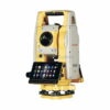
The Carlson CR+ series of Robotic Total Stations provides a choice of 1″, 2″ and 5″ angular resolutions to match the application requirements.

The models are recognizable as the CR1+, CR2+ and CR5+, and all feature the same technologies for a seamless user experience. The instruments are combined with SurvCE or SurvPC on a field computer to access the full range of Carlson survey features for efficiency and automation in a familiar environment. In addition, users have the option for installing SurvCE Basic on board for operation with the instrument only. Customers benefit from technical support for both the robotic total station and SurvCE or SurvPC from one company.

The experienced technical support team provides guidance and instruction for using the instrument and Carlson software for many applications such with surveying, engineering and construction.


Datasheets and manuals

RECOMMENDED DATA COLLECTORS:

Login to view prices

Click here to login or register
Login to view prices

Click here to login or register
Login to view prices

Click here to login or register
Login to view prices

Click here to login or register

RECOMMENDED SOFTWARE:

Login to view prices

Click here to login or register
22%
Login to view prices

Click here to login or register
Login to view prices

Click here to login or register
Login to view prices

Click here to login or register

RECOMMENDED ACCESSORIES:

Login to view prices

Click here to login or register
Login to view prices

Click here to login or register
Login to view prices

Click here to login or register

Carlson CR+

SKU: N/A Categories: ,
Brand:Carlson

Global GPS Systems
What Our Clients Say
4.76 store rating (543 reviews) | 4.65 product rating

Description

CARLSON CR+ SERIES Product review

The Carlson CR+ Robotic Total Station. This Robotic comes with a 1″, 2″ and 5 second angle accuracy. It comes with a 500m reflector less range. Combined with the right field software you can get your surveying work done in no time! Since a robotic automatically finds a tracks youre prism, it eliminates the need for a seconds person to do your stakeouts.  With a Robotic or manual Total station you can generally get around a 1 to 2 millimeter accuracy. However this of course depends on the environments and the quality of the total station itself and its components. The experience of the user also plays a big role in the overal accuracy since properly working with a total station is a lot more complex than with a gnss receiver. A wrong setup from the start can have create inaccurate measurements throughout the whole survey.

Key features

  • Angle accuracy of 1″, 2″ and 5″
  • Distance accuracy of 2mm + 2ppm
  • Max range of 3500 meters with prism
  • Windows operating system
  • Automatically tracks your prism
  • Automatically aims at your prism to find and lock on.


What is it used for?

This Total station can be used for the following applications:

  • Surveying
  • Deformation
  • Earthworks
  • Roadworks
  • Construction


Standard packaging

  • 1x Main unit
  • 1x Carlson SurvCE TS & RTS on-board software
  • 1x Long Range Bluetooth handle
  • 1x SD Card
  • 1x Li-ion Battery
  • 1x Battery charger
  • 1x Tribrach without optical plummet
  • 1x USB cable

Possible total station setups

Depending on your requirements you have the following options:

  • Surveying software. Your Total Station provides you with the data you need but you still need surveying software in order to process this information. Which software you need depends on your needs. We recommend keeping it simple and don’t pay for things you don’t need. Having that said, if you do have to do complicated surveying work make sure you get the right software. Some recommended options are  Carlson, Aplitop andFieldGenius. If you need help, feel free to contact us by phone or via the chat below!
  • Data collector. You might need a tablet or controllerto run your software on. A tablet is however not always needed as some Total stations have onboard software already.  The type of tablet depends on which software you have choosen as some are Android based and some are Windows.
  • Prism pole. In order to get the best performance out of your receiver you want to minimise the disturbances around you and give it a clear sight to the satellites above. That why its recommended attaching your receiver on a 2 meter minimum surveying pole. These come in fixed rods and in telescopic rods.
  • Mini prism sets. These are useful when high accuracy is needed. Mini prism sets allow you to get as close to the ground as possible, minimising the errors in movement when holding the prism pole. Useful for working on foundations and such
  • Tripod and Tribrach. These are needed to setup your Total Station. Recommended for total station use are wooden tripods as these don’t expand when temperatures change. For example when you’re working out in the sun, an aluminum tripod tend to expand a noticeable amount.


Comparable Total Stations

Global GPS Systems is currently in the process of independantly testing every single Total Station on the market. In collaboration with an highly recognised surveying company we will be testing all total stations on its performance in increasingly more difficult environments, accuracy claims and more. Want to know more about this? Please Contact us.

Specifications

Angle Measurements
Accuracy 1” (0.3 mgon), 2” (0.6 mgon), 5” (1.5 mgon)
Method Absolute, continuous, diametrical
Compensation Quadruple axis
Display resolution 0.1” (0.1 mgon)
Telescope
Magnification 30x
Distance Measurements
Prism
Range Accuracy Time Standard mode: 3500 m / 1 mm +
1.5 ppm / typ. 0.8sec*
Long mode: >10,000 m / 5 mm +
2 ppm / typ. 2.5sec
Reflectorless
Range Accuracy Time Precise capture accXess10 500m, 2 mm + 2 ppm**, typ. 3sec, 8×20 mm at 50 m
Motorization
Technology Hybrid Drives
Scout
Range 300m at round prism
TRack
Range 500 m at round prism
Max speed 90 km / h at 100 m
AIM
Range 500 m at round prism
Hz/V accuracy 1”
Technique Image processing
NavLight™
Range 5 m at 150 m
Accuracy 5 cm at 150 m
Interface
Keyboard Two full alphanumeric; 35 keys;
illuminated (2nd optional)
Display Full VGA 640 x 480 color and touch
with LED backlight
Data recording 1 GB internal memory; removable
SD card and USB stick
Ports Serial; USB; internal Bluetooth;
long- range Bluetooth handle and
external power
Operating system Microsoft Windows CE 6.0
Plummet
Type Laser point, adjustable brightness
Accuracy 1.5 mm at 1.5 m instrument height
Physical Specifications
Weight 5.0 – 5.3 kg
(w/o battery and tribrach)
Operating /
storage temperature
–20°C to 50°C / -40°C to +70°C
Protection class IP55 dust and waterproof rating
Humidity 95%, non-condensing
Power Supply
Internal battery Removable Li-Ion 4.4 Ah / 7.4 V
Operating time 7-10 h***
Reviews (0)

Reviews

There are no reviews yet.

Only logged in customers who have purchased this product may leave a review.

RTK GNSS With 60° tilt:

GPS receivers

South Galaxy G2

GPS receivers

South INNO7

RTK GNSS Receivers

Kolida K30

GPS receivers

Carlson BRX7

GPS receivers

Stonex S990A

42%

GPS receivers

Kolida K1 Pro

GPS receivers

South Galaxy G3

GPS receivers

EFIX F7

GPS receivers

South Galaxy G7

RTK GNSS With internet:

GPS receivers

South Galaxy G2

GPS receivers

South INNO7

RTK GNSS Receivers

Kolida K30

GPS receivers

Emlid Reach RS2+

GPS receivers

Tersus Oscar

GPS receivers

EFIX F4

GPS receivers

Carlson BRX7

GPS receivers

Stonex S990A

42%

GPS receivers

Kolida K1 Pro

Select your currency