


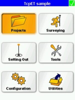
Aplitop TcpET
This product is Available
Contact our experts for the best possible price and configuration.
This application, installed in a pocket PC, allows the user to survey and stake out topographical data using a wide range of total stations, connected through a standard cable or through wireless Bluetooth technology. In motorised stations, the software will automatically direct the device to the desired location. The program provides numerous options and may be used for traditional mapping or surveying, and for projects involving linear works.
Valued customers:


Find RTK Networks
Search NTRIP providers and connect to reliable RTK correction services.
Description
All-in-one solution for surveying and setting-out linear works with total stations
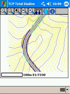
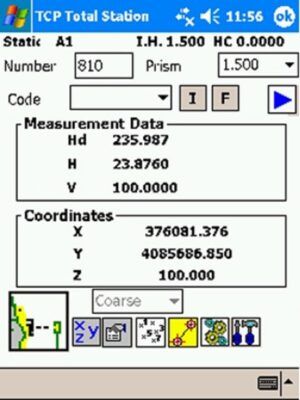
Before starting the survey, the program controls the direction of the system by comparing the theoretical data with the measured data. Points or stations may then be taken by recording the data as coordinates or as observations, indicating the height of the prism and code for each one. These files can subsequently be calculated using the TCP Digital Terrain Model or other commercial programs. The application likewise provides the ability to measure cross sections, whilst allowing the user to control the current station and the distance to the alignment at all times.
Setting out
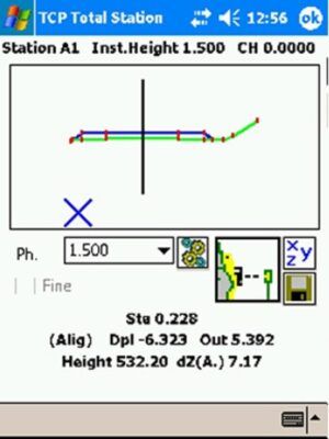
The software provides numerous options for stake out points, roads and geometric constructions with lines. The prompts provide the information regarding the current position and the objective position at all times. For setting out sections over an alignment, different options for stake out sections, heads and shoulders, the cross sections, station and code, the station and displacement, etc. The screen Surveying and Setting Out using Total Station – © Aplitop 2 shows precise information regarding the distance to the alignment and the profile, the difference in the spot height and the plan and elevation graphs of the current section.
Tools
Apart from the options mentioned above, the software provides the ability to calculate distances and areas between points, to calculate the coordinates of a point over the plan and elevation alignment, to analyse a point using a digital model, to find intersections between straight lines and/or circles, to find the current position through an inverse intersection, to use the geodesic calculator, etc.
File Management
The application works with ASCII files in a format that is compatible with TCP – Digital Terrain Model, although it also contains a program for PCs that allow the user to convert the files containing plan and elevation alignment and transversal profiles to the most common formats used in the market. All of the information exchanged between the PC and the Pocket PC is transmitted in a very simple manner using Microsoft ActiveSync. Each project may contain files with stations, points, longitudinal profiles, cross sections, plan and elevation alignments, superelevations, surfaces and DFX cartography, allowing the user to edit and add new information and draw this information on the screen.
CAD
The TcpCAD module may also be purchased along with the application, in order to gather data and map over a digital cartography in a DFX or AutoCAD DWG format. This module provides options for viewing the drawings with zoom and in real time framing, layer control, colours and line type, drawing lines, polylines, arcs, circles and texts and the most common editing commands. This component allows the user to apply the browse options over cartography and data capture point-by-point or continuously, by drawing specific blocks or polylines in real time depending on the assigned codes. It is also possible to graphically design the points that will be mapped or used for defining the local adjustments.
Datasheets & Manuals
Datasheets and manuals
Additional information
| Operating system | Windows |
|---|---|
| License interval | Lifetime |
| Brand | Aplitop |
Reviews (0)
Only logged in customers who have purchased this product may leave a review.

Reviews
There are no reviews yet