

 GPS & GNSS
 Lidar scanning
 Total Station
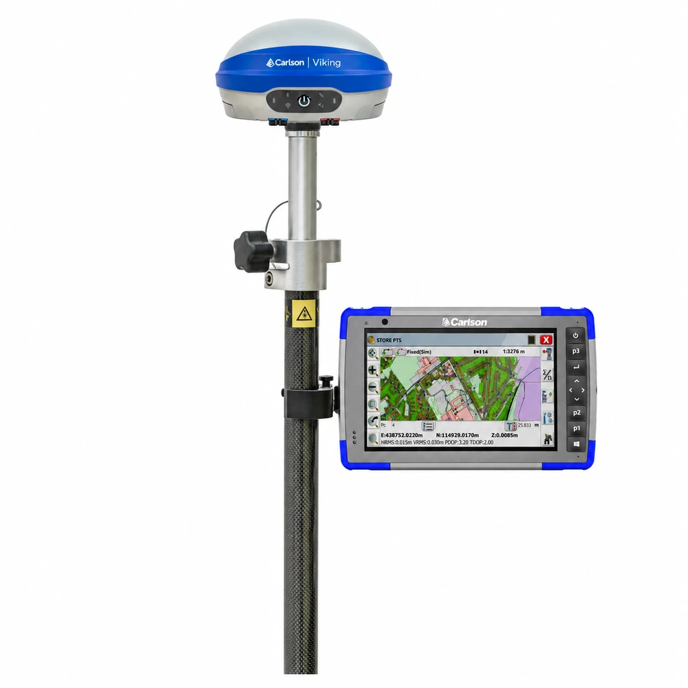
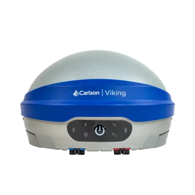
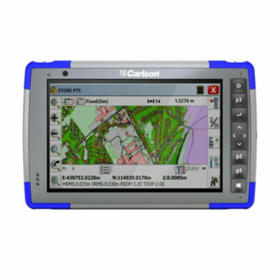
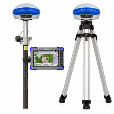
Carlson Viking RTK Rover Set
Get the best price for your setup
Contact our experts for the best possible price and configuration.
- Fast response
- Expert configuration advice
- No overpaying for features you do not need
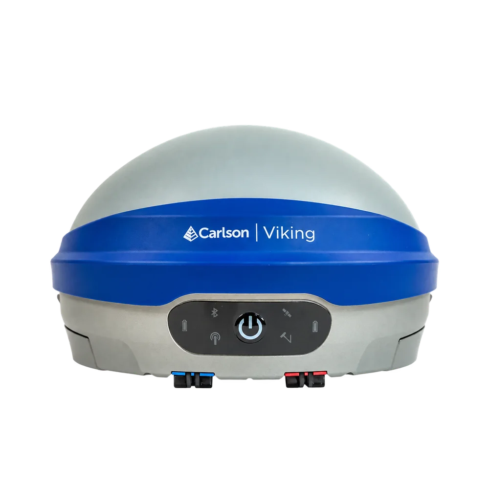
The Carlson Viking RTK Rover Set with RT4+ combines Carlson’s flagship survey-grade GNSS receiver with a rugged Windows data collector for a complete field surveying solution. The Viking uses dual GNSS RTK modules and three independent RTK engines with Carlson Triple-Fix technology, helping surveyors work with greater confidence around buildings, trees, machinery and other environments where satellite signals can be difficult. Calibration-free IMU tilt compensation allows the pole to be tilted up to 60°, making it easier to measure corners, kerbs, trenches, building edges and other hard-to-reach points.
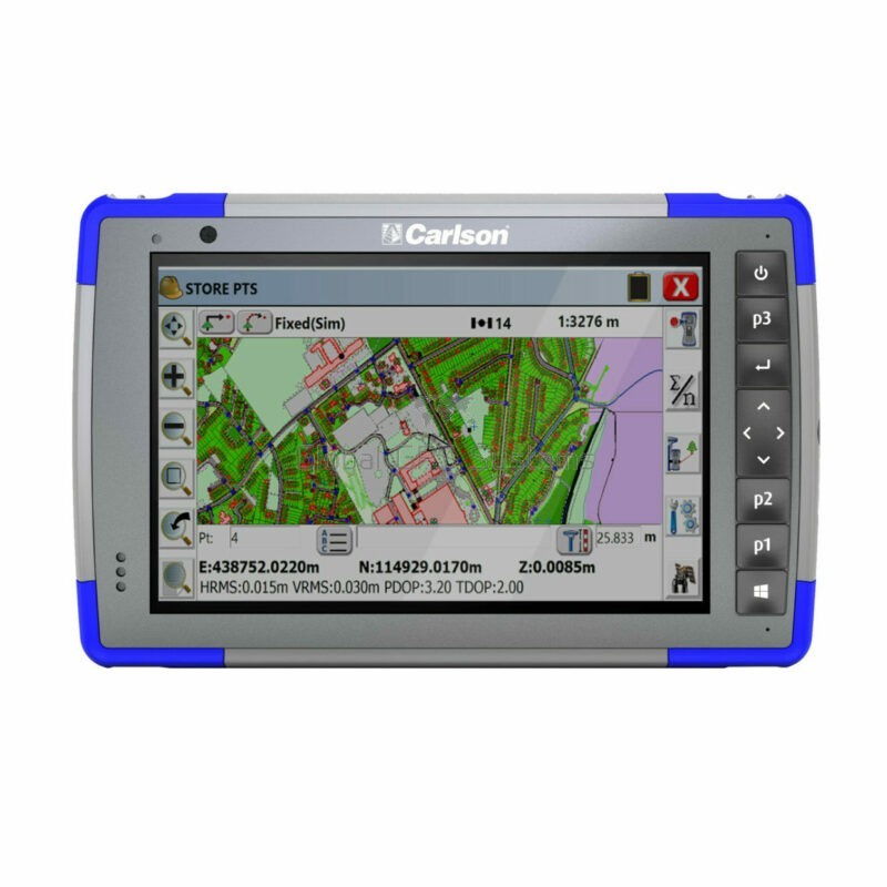
The Carlson RT4+ provides the field interface for the rover. Its 7-inch outdoor touchscreen, Windows 11 operating system, Intel N200 processor, 16 GB RAM and 256 GB SSD make it well suited to Carlson SurvPC and demanding survey projects. Long-range Bluetooth provides communication between the data collector and Viking, while Wi-Fi and 4G LTE support connected field workflows. Together, the Viking and RT4+ create a practical RTK rover setup for land surveying, construction layout, civil engineering, GIS mapping and accurate ground control work.
Carlson Viking RTK Rover Set Highlights
| GNSS receiver | Carlson Viking with dual GNSS RTK modules and 3 independent RTK engines |
|---|---|
| RTK accuracy | Horizontal 0.6 cm + 0.5 ppm and vertical 1 cm + 1 ppm |
| IMU tilt compensation | Calibration-free pole tilt compensation up to 60° |
| Satellite tracking | 632 channels with GPS, GLONASS, Galileo, BeiDou, QZSS and NavIC |
| Data collector | Carlson RT4+ with Windows 11, Intel N200, 16 GB RAM and 256 GB SSD |
| Display | 7 inch high-visibility touchscreen designed for glove, stylus and wet use |
| Connectivity | Bluetooth, Wi-Fi, 4G LTE plus Viking cellular and UHF communication options |
| Field protection | Viking IP67 and RT4+ IP68 rugged field construction |
Valued customers:










Find RTK Networks
Search NTRIP providers and connect to reliable RTK correction services.
Description
Complete Carlson RTK rover solution for professional fieldwork
The Carlson Viking RTK Rover Set with RT4+ brings together Carlson’s high-precision Viking GNSS receiver and rugged RT4+ Windows data collector in one professional rover workflow. Designed for land surveying, construction layout, engineering, GIS and other centimetre-level positioning applications, the set gives field crews both the positioning hardware and the controller needed to measure, stake and record survey data efficiently.
The Viking provides the survey-grade position, while the RT4+ gives the operator access to Carlson SurvPC and the project information required in the field. This separation makes the system flexible: the GNSS receiver remains on the survey pole where it has a clear view of the sky, while the surveyor works from the RT4+ touchscreen to collect points, perform stakeout and manage the job.
Triple Fix GNSS for greater confidence in difficult locations
At the heart of the rover is the Carlson Viking, which uses two GNSS RTK modules and three independent RTK engines. Carlson’s Triple-Fix architecture allows multiple RTK solutions to be calculated and compared rather than relying on a single positioning engine.
This is particularly useful on real construction and survey sites where GNSS conditions are rarely perfect. Buildings, vehicles, machinery, fences and vegetation can block or reflect satellite signals. Having independent RTK calculations available gives the field operator additional information when assessing the quality of a fixed position. Good survey procedures and independent checks are still important, but the system is designed to provide more confidence when working outside completely open-sky conditions.
Centimetre level RTK positioning
The Viking is specified for RTK horizontal accuracy of 0.6 cm + 0.5 ppm and vertical accuracy of 1 cm + 1 ppm under suitable operating conditions. Its 632-channel GNSS system tracks multiple frequencies across GPS, GLONASS, Galileo, BeiDou, QZSS and NavIC.
Multi-constellation tracking gives the receiver access to a large number of satellites, helping maintain useful satellite geometry as the operator moves around a site. The Viking also incorporates technology intended to reduce the effects of multipath and radio interference, both of which are common concerns when surveying close to buildings, metal structures and heavy equipment.
Survey with the pole tilted up to 60 degrees
The integrated IMU provides calibration-free pole tilt compensation up to 60°. Instead of carefully levelling the survey pole for every observation, the operator can place the pole tip directly on the point and allow the receiver to compensate for the pole angle.
This makes everyday measurements faster and makes points that are difficult to occupy vertically much easier to survey. Building corners, kerbs, walls, fences, trenches, utility features and points underneath obstructions can often be measured without repositioning the pole simply to keep the antenna directly above the point.
Carlson RT4 Plus field controller
The Carlson RT4+ acts as the field computer for the Viking rover. It runs Microsoft Windows 11 and uses an Intel N200 processor with 16 GB LPDDR5 RAM and a 256 GB PCIe SSD. This gives the controller enough computing capacity for survey jobs containing coordinate data, CAD information, background maps, surfaces and other project files.
A 7-inch 1280 × 800 high-visibility display is designed for outdoor use. The capacitive touchscreen can be operated with gloves, a suitable stylus and in wet conditions, while physical navigation and programmable keys provide another way to control common field functions.
Built around Carlson SurvPC
Using Carlson SurvPC, the RT4+ becomes the main interface between the surveyor and the Viking. Measurements, coordinate information, stakeout guidance and instrument status can be handled from the same field software. Carlson currently requires SurvPC 7.12 or later for current Viking support.
Typical workflows include topographic point collection, construction stakeout, line and arc stakeout, checking elevations, recording feature information and working with digital project data. Because SurvPC also supports many other GNSS receivers and total stations, the RT4+ can remain useful as a field controller when a company operates several different types of survey equipment.
Fast construction layout and setting out
For construction crews, the rover can be used to take digital design coordinates directly into the field. Operators can navigate to points, lines and other project geometry without relying on tapes or manual offsets for every measurement. Tilt compensation is especially useful around excavations, foundations, kerbs and structures where keeping a conventional GNSS pole perfectly vertical can slow down the work.
The combination is suitable for setting out, position checks, as-built surveys, earthworks measurements and general site control where RTK GNSS accuracy is appropriate for the task.
Land surveying and engineering applications
Surveyors can use the Viking and RT4+ for control work, detail surveys, topographic measurements and stakeout. The rover’s combination of multi-constellation GNSS and tilt compensation is particularly useful when many individual points need to be measured throughout the day.
Civil engineers and site teams can use the same equipment for checking coordinates and elevations against design information. Data collected in SurvPC can then be moved into the wider Carlson software workflow or exported using commonly used survey data formats.
GIS and asset mapping
The rover set can also be used for high-accuracy GIS data collection. Utility assets, inspection points, drainage features, road furniture and other infrastructure can be positioned using the Viking while attributes and project information are managed on the RT4+.
This allows organisations that need more accuracy than the built-in positioning of a conventional tablet to combine centimetre-level RTK measurements with a practical Windows field interface. SurvPC also supports workflows involving Esri ArcGIS Online where the appropriate software and services are configured.
Ground control for drone surveying
Drone mapping teams can use the rover to measure ground control points and independent checkpoints for photogrammetry projects. Instead of relying solely on the drone’s navigation solution, accurately surveyed points can be used to establish or independently verify the coordinate framework of the final dataset.
The Viking can also be reconfigured for base-station applications when required, giving the receiver additional flexibility for organisations using both traditional surveying and RTK drone workflows.
Flexible RTK correction options
As a rover, the Viking requires RTK correction data from a suitable source. Depending on the project and configuration, corrections can be received from an NTRIP network, another compatible GNSS base station or a local UHF radio base. Integrated cellular, UHF, Wi-Fi and Bluetooth communication give the receiver several options for fitting into different field setups.
This is important when choosing a rover set because an RTK rover does not independently create centimetre-level RTK corrections. The available correction network, base station and communication method should therefore be considered when configuring the system for a particular country or project.
Wireless connection between rover and controller
The RT4+ includes long-range Bluetooth 5.3 for communication with compatible survey equipment as well as Wi-Fi 6 and 4G LTE for connected field workflows. This allows the controller to communicate with the Viking without adding unnecessary cables to the survey pole.
Cellular connectivity can also be useful when downloading project information, accessing online services or working with internet-based RTK corrections. Actual connectivity depends on the SIM, network coverage and correction service being used.
Designed for full days outside
Both components are built for professional outdoor use. The Viking has an IP67-rated enclosure and dual removable batteries that can be exchanged in the field. The RT4+ carries an IP68 rating and has a removable 43.2 Wh battery rated for up to 15 hours of operation under specified conditions.
The RT4+ is designed for operation between -20°C and 50°C and uses impact-absorbing external protection around the tablet. Carlson also specifies environmental testing based on MIL-STD procedures for its field hardware. These characteristics make the rover set more appropriate for regular survey and construction use than pairing a professional GNSS receiver with a standard consumer tablet.
One rover for survey construction and GIS teams
The Carlson Viking RTK Rover Set with RT4+ is suited to companies that want a versatile rover rather than a receiver designed around one narrow application. A land surveyor can use it for detail and stakeout work, a construction crew can use it for site layout and as-built measurements, a GIS technician can collect accurately positioned assets and a drone surveyor can establish ground control and checkpoints.
For organisations already using Carlson software, the combination also provides a familiar workflow between field measurements and office processing.
Carlson Viking rover set from Global GPS Systems
Global GPS Systems can help configure the Carlson Viking and RT4+ around the way your team actually works. This includes selecting the appropriate Carlson SurvPC configuration and checking requirements for RTK network corrections, UHF communication, survey poles, mounts and other field accessories.
If you are replacing an existing rover, compatibility with your current RTK correction service or base station can also be considered when choosing the setup. For surveyors, construction professionals, engineers and GIS teams looking for a rugged Windows-based rover with centimetre-level GNSS positioning and advanced tilt compensation, the Viking and RT4+ form a capable complete field solution.
Specifications
Carlson Viking + RT4 Rover Set FAQ
Rover Set & Applications
What is the Carlson Viking + RT4 Rover Set?
The Carlson Viking + RT4 Rover Set combines the Carlson Viking survey-grade GNSS receiver with the Carlson RT4 rugged data collector. The Viking determines the high-accuracy GNSS position, while the RT4 runs Carlson field software for configuring the rover, collecting points, staking out coordinates and managing survey data.
Who is the Carlson Viking + RT4 Rover Set designed for?
The rover set is designed for land surveyors, civil engineers, construction layout crews, GIS professionals and other field users who require centimeter-level RTK positioning together with a rugged Windows data collector.
What can the Carlson Viking Rover Set be used for?
Typical applications include topographic surveying, boundary and cadastral surveying, construction stakeout, site layout, as-built surveys, road and infrastructure projects, GIS data collection and other high-accuracy positioning tasks.
What is the difference between the Carlson Viking and the RT4 in this rover set?
The Viking is the survey-grade GNSS receiver that calculates the precise RTK position. The RT4 is the field data collector used to operate survey software, control the receiver, view measurements, store points and manage project data. The RT4's own internal GNSS is not used as a replacement for the Viking when centimeter-level survey accuracy is required.
Is a GNSS base station included with this rover set?
This configuration is a rover set. The rover requires RTK correction data from a suitable source, such as a compatible GNSS base station or an NTRIP/RTK correction network. A separate base receiver is not required when an appropriate network correction service is available.
Can the Carlson Viking also be used as a base station?
Yes. The Carlson Viking can be configured as either an RTK rover or an RTK base station. When the Viking supplied with this set is being used as a base, however, a separate GNSS receiver would be required to operate as the rover.
GNSS Accuracy, Triple-Fix & Tilt Compensation
What accuracy does the Carlson Viking Rover Set provide?
Carlson specifies RTK accuracy for the Viking at 0.6 cm + 0.5 ppm horizontally and 1 cm + 1 ppm vertically. Actual field accuracy depends on conditions including satellite geometry, multipath, atmospheric and ionospheric conditions, correction quality and distance from the correction source.
What is Carlson Viking Triple-Fix technology?
Triple-Fix uses two GNSS RTK modules and three independent RTK engines to independently evaluate the positioning solution. The system can compare these solutions to increase confidence that an RTK fixed position is correct, which is particularly useful when working in difficult GNSS environments.
What is the Carlson GAMA RTK engine?
GAMA is Carlson's RTK navigation engine used in the Viking. It works with the receiver's GNSS observations, signal processing and inertial sensors to provide high-precision positioning while helping the receiver maintain reliable solutions in changing field conditions.
Does the Carlson Viking Rover Set support tilt compensation?
Yes. The Viking has an integrated IMU that provides calibration-free pole tilt compensation. This allows measurements to be taken without keeping the survey pole perfectly vertical, making it easier to measure points beside walls, underneath obstacles or in locations where positioning the pole vertically is difficult.
How accurate is the Viking when the survey pole is tilted?
Using a 2 m pole, Carlson specifies tilt-compensated accuracy of approximately 0.7 cm at 20 degrees, 0.9 cm at 30 degrees, 1.2 cm at 45 degrees and 1.5 cm at 60 degrees. Actual results can vary with GNSS conditions and the measurement environment.
Does the Viking tilt sensor need to be calibrated?
No manual field calibration is normally required. The Viking uses a calibration-free IMU and is designed to be immune to magnetic interference. This allows the tilt function to be used around vehicles, machinery and other environments where magnetic-compass-based systems can be affected.
RT4 Data Collector, SurvPC & Connectivity
What is the Carlson RT4 data collector used for in this rover set?
The Carlson RT4 acts as the field controller for the Viking. It provides a rugged Windows platform for running Carlson SurvPC, configuring the GNSS rover, monitoring RTK status, collecting survey points, performing stakeout and managing project files in the field.
Does the Carlson Viking work with Carlson SurvPC on the RT4?
Yes. The Viking is designed for integration with Carlson SurvPC. Carlson specifies SurvPC 7.12 or later for current Viking support and firmware workflows, so the RT4 should be equipped with a compatible SurvPC version when used with the Viking.
Can the Carlson Viking and RT4 connect wirelessly?
Yes. Both devices support Bluetooth connectivity, allowing the RT4 to communicate with and control the Viking without a data cable during normal field operation.
Can this rover set receive NTRIP corrections?
Yes. The Viking can operate as a network RTK rover and receive correction data using supported NTRIP workflows. An internet connection and access to a compatible correction service are required when using network RTK.
Can the Carlson Viking receive corrections by UHF radio?
Yes. The Viking includes a configurable UHF radio with transmit and receive capability. In rover mode it can receive compatible RTK corrections from a suitable base station using radio communication, providing an alternative to internet-based NTRIP corrections.
Which satellite systems does the Carlson Viking track?
The Viking is a 632-channel multi-frequency GNSS receiver capable of simultaneously tracking major satellite constellations including GPS, GLONASS, Galileo, BeiDou, QZSS and NavIC. Using multiple constellations and frequencies gives the receiver access to more satellite observations for positioning.
Field Performance, Batteries & Durability
Can the Carlson Viking Rover Set be used in difficult GNSS environments?
Yes. The Viking is designed specifically to improve positioning reliability in challenging environments. It includes multipath mitigation, interference monitoring, anti-jamming and anti-spoofing technologies, together with its Triple-Fix architecture. Buildings, trees and other obstructions can still reduce GNSS performance when satellite visibility becomes severely restricted.
Is the Carlson Viking waterproof and suitable for outdoor surveying?
Yes. The Viking has an IP67 rating for protection against dust and temporary water immersion. It is also tested to MIL-STD-810G procedures for demanding field conditions and is designed to withstand the shock, vibration and environmental exposure associated with professional surveying.
Is the Carlson RT4 rugged and waterproof?
Yes. The Carlson RT4 is a rugged field tablet with an IP68 dust and water resistance rating and a design tested to MIL-STD-810G standards. Its 7-inch IllumiView display, strengthened glass and rugged enclosure are intended for surveying and construction work in demanding outdoor environments.
How long does the Carlson Viking battery last?
The Viking uses two removable lithium batteries and is designed for extended field operation. Carlson documentation specifies approximately 10 or more hours of operation depending on configuration and usage. Battery life varies with UHF transmission, cellular connectivity, temperature and other operating conditions.
Can the Viking batteries be changed while surveying?
Yes. The Viking uses two hot-swappable batteries. One battery can be replaced while the other continues to power the receiver, helping crews remain operational during longer survey sessions without shutting down the rover.
How long does the Carlson RT4 battery last?
The Carlson RT4 is designed for all-day field operation, with Carlson specifying approximately 12 to 15 hours of battery life depending on use. Screen brightness, wireless communications, cellular connectivity, temperature and other settings can affect actual runtime.
Reviews (0)
Only logged in customers who have purchased this product may leave a review.
FAQ
Carlson Viking + RT4 Rover Set FAQ
Rover Set & Applications
What is the Carlson Viking + RT4 Rover Set?
The Carlson Viking + RT4 Rover Set combines the Carlson Viking survey-grade GNSS receiver with the Carlson RT4 rugged data collector. The Viking determines the high-accuracy GNSS position, while the RT4 runs Carlson field software for configuring the rover, collecting points, staking out coordinates and managing survey data.
Who is the Carlson Viking + RT4 Rover Set designed for?
The rover set is designed for land surveyors, civil engineers, construction layout crews, GIS professionals and other field users who require centimeter-level RTK positioning together with a rugged Windows data collector.
What can the Carlson Viking Rover Set be used for?
Typical applications include topographic surveying, boundary and cadastral surveying, construction stakeout, site layout, as-built surveys, road and infrastructure projects, GIS data collection and other high-accuracy positioning tasks.
What is the difference between the Carlson Viking and the RT4 in this rover set?
The Viking is the survey-grade GNSS receiver that calculates the precise RTK position. The RT4 is the field data collector used to operate survey software, control the receiver, view measurements, store points and manage project data. The RT4's own internal GNSS is not used as a replacement for the Viking when centimeter-level survey accuracy is required.
Is a GNSS base station included with this rover set?
This configuration is a rover set. The rover requires RTK correction data from a suitable source, such as a compatible GNSS base station or an NTRIP/RTK correction network. A separate base receiver is not required when an appropriate network correction service is available.
Can the Carlson Viking also be used as a base station?
Yes. The Carlson Viking can be configured as either an RTK rover or an RTK base station. When the Viking supplied with this set is being used as a base, however, a separate GNSS receiver would be required to operate as the rover.
GNSS Accuracy, Triple-Fix & Tilt Compensation
What accuracy does the Carlson Viking Rover Set provide?
Carlson specifies RTK accuracy for the Viking at 0.6 cm + 0.5 ppm horizontally and 1 cm + 1 ppm vertically. Actual field accuracy depends on conditions including satellite geometry, multipath, atmospheric and ionospheric conditions, correction quality and distance from the correction source.
What is Carlson Viking Triple-Fix technology?
Triple-Fix uses two GNSS RTK modules and three independent RTK engines to independently evaluate the positioning solution. The system can compare these solutions to increase confidence that an RTK fixed position is correct, which is particularly useful when working in difficult GNSS environments.
What is the Carlson GAMA RTK engine?
GAMA is Carlson's RTK navigation engine used in the Viking. It works with the receiver's GNSS observations, signal processing and inertial sensors to provide high-precision positioning while helping the receiver maintain reliable solutions in changing field conditions.
Does the Carlson Viking Rover Set support tilt compensation?
Yes. The Viking has an integrated IMU that provides calibration-free pole tilt compensation. This allows measurements to be taken without keeping the survey pole perfectly vertical, making it easier to measure points beside walls, underneath obstacles or in locations where positioning the pole vertically is difficult.
How accurate is the Viking when the survey pole is tilted?
Using a 2 m pole, Carlson specifies tilt-compensated accuracy of approximately 0.7 cm at 20 degrees, 0.9 cm at 30 degrees, 1.2 cm at 45 degrees and 1.5 cm at 60 degrees. Actual results can vary with GNSS conditions and the measurement environment.
Does the Viking tilt sensor need to be calibrated?
No manual field calibration is normally required. The Viking uses a calibration-free IMU and is designed to be immune to magnetic interference. This allows the tilt function to be used around vehicles, machinery and other environments where magnetic-compass-based systems can be affected.
RT4 Data Collector, SurvPC & Connectivity
What is the Carlson RT4 data collector used for in this rover set?
The Carlson RT4 acts as the field controller for the Viking. It provides a rugged Windows platform for running Carlson SurvPC, configuring the GNSS rover, monitoring RTK status, collecting survey points, performing stakeout and managing project files in the field.
Does the Carlson Viking work with Carlson SurvPC on the RT4?
Yes. The Viking is designed for integration with Carlson SurvPC. Carlson specifies SurvPC 7.12 or later for current Viking support and firmware workflows, so the RT4 should be equipped with a compatible SurvPC version when used with the Viking.
Can the Carlson Viking and RT4 connect wirelessly?
Yes. Both devices support Bluetooth connectivity, allowing the RT4 to communicate with and control the Viking without a data cable during normal field operation.
Can this rover set receive NTRIP corrections?
Yes. The Viking can operate as a network RTK rover and receive correction data using supported NTRIP workflows. An internet connection and access to a compatible correction service are required when using network RTK.
Can the Carlson Viking receive corrections by UHF radio?
Yes. The Viking includes a configurable UHF radio with transmit and receive capability. In rover mode it can receive compatible RTK corrections from a suitable base station using radio communication, providing an alternative to internet-based NTRIP corrections.
Which satellite systems does the Carlson Viking track?
The Viking is a 632-channel multi-frequency GNSS receiver capable of simultaneously tracking major satellite constellations including GPS, GLONASS, Galileo, BeiDou, QZSS and NavIC. Using multiple constellations and frequencies gives the receiver access to more satellite observations for positioning.
Field Performance, Batteries & Durability
Can the Carlson Viking Rover Set be used in difficult GNSS environments?
Yes. The Viking is designed specifically to improve positioning reliability in challenging environments. It includes multipath mitigation, interference monitoring, anti-jamming and anti-spoofing technologies, together with its Triple-Fix architecture. Buildings, trees and other obstructions can still reduce GNSS performance when satellite visibility becomes severely restricted.
Is the Carlson Viking waterproof and suitable for outdoor surveying?
Yes. The Viking has an IP67 rating for protection against dust and temporary water immersion. It is also tested to MIL-STD-810G procedures for demanding field conditions and is designed to withstand the shock, vibration and environmental exposure associated with professional surveying.
Is the Carlson RT4 rugged and waterproof?
Yes. The Carlson RT4 is a rugged field tablet with an IP68 dust and water resistance rating and a design tested to MIL-STD-810G standards. Its 7-inch IllumiView display, strengthened glass and rugged enclosure are intended for surveying and construction work in demanding outdoor environments.
How long does the Carlson Viking battery last?
The Viking uses two removable lithium batteries and is designed for extended field operation. Carlson documentation specifies approximately 10 or more hours of operation depending on configuration and usage. Battery life varies with UHF transmission, cellular connectivity, temperature and other operating conditions.
Can the Viking batteries be changed while surveying?
Yes. The Viking uses two hot-swappable batteries. One battery can be replaced while the other continues to power the receiver, helping crews remain operational during longer survey sessions without shutting down the rover.
How long does the Carlson RT4 battery last?
The Carlson RT4 is designed for all-day field operation, with Carlson specifying approximately 12 to 15 hours of battery life depending on use. Screen brightness, wireless communications, cellular connectivity, temperature and other settings can affect actual runtime.

 GPS & GNSS
 Total Stations
 Data collectors
 Software
 Correction services
 Machine control
 External radio
 Marine
 Accessories
Reviews
There are no reviews yet