
 GPS & GNSS
 Lidar scanning
 Total Station
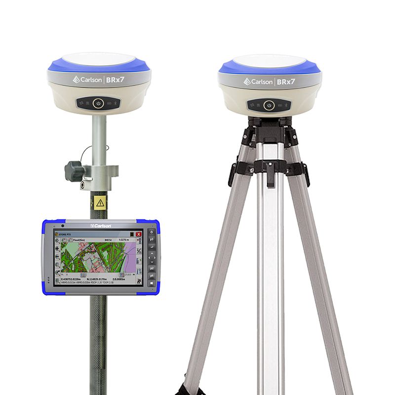
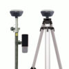
Carlson BRx7 RTK GNSS Rover Base Set with IMU Tilt
This product is available
Get the best price for your setup
Contact our experts for the best possible price and configuration.
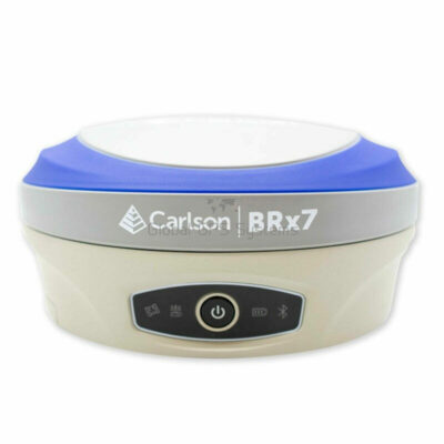
The Carlson BRx7 Rover Base Set is a complete RTK GNSS surveying system for crews that want to create their own local correction source without depending on a permanent reference network. One BRx7 is installed over a known point as the base, while the second receiver is used as the rover for centimetre-level measuring and setting out across the job site.
Both receivers track multiple frequencies from GPS, GLONASS, Galileo, BeiDou, QZSS and IRNSS. The rover’s integrated tilt compensation makes it easier to measure corners, kerbs, utility points and locations beside obstacles without keeping the pole perfectly vertical. Corrections can be transferred through the integrated UHF radios or compatible cellular workflows, making the set suitable for land surveying, construction, infrastructure and GIS projects.
Carlson BRx7 Rover Base Set Highlights
| Receiver configuration | Two BRx7 receivers for base and rover operation |
|---|---|
| GNSS tracking | 800+ channels with GPS, GLONASS, Galileo, BeiDou, QZSS and IRNSS |
| RTK accuracy | 8 mm + 1 ppm RMS under suitable operating conditions |
| IMU tilt compensation | 2 cm within 30° and 5 cm within 60° using a 1.8 m pole |
| Correction communication | Integrated UHF radio, LTE cellular, Wi-Fi, Bluetooth and serial |
| Field controller | Carlson RT4 with SurvPC or SurvCE field software |
| Environmental protection | IP67 housing with operation from -40°C to +65°C |
| Battery system | Up to 12 hours with two hot-swappable batteries per receiver |
Valued customers:










Find RTK Networks
Search NTRIP providers and connect to reliable RTK correction services.
Description
Complete RTK base and rover system for independent fieldwork
The Carlson BRx7 RTK GNSS Rover Base Set gives surveyors and construction teams the equipment required to establish a local base station and work with a mobile rover. It is a practical solution for projects where no suitable network RTK service is available, mobile coverage is unreliable or the crew wants to control its own correction source.
One BRx7 receiver is positioned over a known or newly established control point and transmits correction data to the second BRx7. The rover then uses those corrections to calculate accurate coordinates while the operator moves around the site. This setup supports topographic surveys, construction stakeout, earthworks, utility installation, road projects, as-built measurements and GIS asset collection.
Multi-constellation tracking across both receivers
Each BRx7 uses more than 800 channels to track multiple frequencies from GPS, GLONASS, Galileo, BeiDou, QZSS and IRNSS. Working with several satellite constellations gives the system more observations from which to calculate a position, helping crews maintain productive RTK operation when part of the sky is obstructed by buildings, machinery, vegetation or terrain.
Carlson’s Athena RTK engine processes the correction data, while SureFix technology provides additional information about the quality of the current RTK solution. This helps operators assess whether a point has been measured with a reliable fixed position before storing or setting it out.
Local UHF corrections without relying on an RTK network
The integrated UHF radios allow the base receiver to transmit corrections directly to the rover. This is particularly useful on remote construction sites, agricultural land, infrastructure corridors and other locations where mobile internet is unavailable or inconsistent.
Available radio configurations cover supported frequencies in the 410–470 MHz and 902.4–928 MHz ranges. The permitted frequency, transmission power and licensing requirements vary by country, so the correct regional configuration must be selected before use.
The BRx7 also supports LTE cellular communication, Wi-Fi, Bluetooth and serial connections. These options allow the receivers to work with network RTK services, internet-based base-to-rover workflows, external radios and compatible field controllers when project requirements change.
IMU tilt compensation for faster point collection
The rover receiver includes tilt compensation that calculates the position of the survey pole tip while the pole is leaning. Operators can therefore measure building corners, kerbs, manholes, fence lines and points beside parked equipment without repeatedly centring the pole bubble.
This is also useful on embankments, excavations and uneven ground where holding a pole perfectly vertical can be slow or uncomfortable. The published performance is 2 cm within a 30-degree tilt and 5 cm within a 60-degree tilt when using a 1.8 m pole under suitable RTK conditions. Conventional checks should still be carried out for control points and measurements requiring the highest possible precision.
Practical accuracy for surveying and construction
The BRx7 has a published RTK precision of 8 mm + 1 ppm RMS and an initialization time of less than 10 seconds under suitable conditions. In practice, the result depends on satellite visibility, baseline length, atmospheric activity, multipath and the quality of the correction link.
Land surveyors can use the set for control, detail surveys, boundary work and as-built records. Construction teams can set out foundations, roads, utilities, drainage, piles and earthworks directly from digital design data. Civil engineers and GIS crews can record accurate positions for infrastructure, environmental features and underground or above-ground assets.
Carlson controller and field software workflow
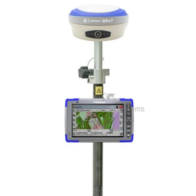
The set includes a Carlson RT4 data collector with Carlson SurvPC or SurvCE field software, depending on the chosen configuration. The software provides tools for configuring the base and rover, monitoring GNSS status, collecting coded points, setting out coordinates, working with surfaces and exchanging common survey and CAD files.
Bluetooth communication connects the rover to the controller without unnecessary cables. The BRx7 WebUI can also be accessed from a Wi-Fi-capable phone, tablet or computer to review receiver status, change settings, configure radio parameters, download recorded data and manage firmware.
Designed for regular outdoor site use
Both BRx7 receivers have IP67-rated housings that protect them against dust and temporary water immersion. Their specified operating temperature range of -40°C to +65°C supports work in a wide range of climates, while the rugged enclosure is designed to survive a two-metre pole drop onto concrete.
Each receiver uses two removable batteries and can operate for up to 12 hours. The batteries are hot-swappable, allowing one battery to be replaced while the second continues powering the receiver. This reduces interruptions during long survey days and remote projects.
Equipment supplied with the rover base set
The listed package combines two Carlson BRx7 receivers with a Carlson RT4 data collector, SurvPC or SurvCE field software, a rover pole, controller bracket, tripod, tribrach and adapter. These components provide the main equipment required to install the base securely and operate the rover in the field.
Package components can be adjusted to suit the required controller, software, radio frequency and field workflow. Final contents should therefore be confirmed when configuring the system.
Configuration and support from Global GPS Systems
Global GPS Systems can help select the correct regional UHF frequency, Carlson software licence, controller configuration and accessories for the intended project. Support is also available when matching the set to existing control networks, external radios or other Carlson equipment.
Before ordering, confirm the permitted radio frequency and licensing rules for the country of operation, as well as the required software modules and coordinate-system workflow.
Datasheets & Manuals
Datasheets and manuals
Specifications
Carlson BRx7 Rover and Base Set Specifications
System Overview
| Product Type | Complete multi-constellation, multi-frequency GNSS RTK rover and base system |
|---|---|
| Primary Applications | Land surveying, construction layout, engineering, topographic surveying, GIS data collection, mapping, marine surveying and precision positioning |
| Receiver Configuration | Two Carlson BRx7 GNSS smart antennas configured as one RTK base and one RTK rover |
| Supported Workflows | UHF base-to-rover RTK, cellular base-to-rover RTK, network RTK rover, NTRIP, static GNSS surveying and Atlas L-band positioning |
| Base-to-Rover Communication | Integrated UHF radio or cellular internet connection through compatible correction services and software |
| GNSS Engine | Athena RTK technology |
| Receiver Board | Phantom 40 OEM GNSS board |
| RTK Validation Technology | SureFix high-fidelity RTK solution-quality processing |
| Tilt Compensation | Integrated inertial tilt sensor with pole-angle compensation up to 60° |
| Magnetic Interference Resistance | IMU tilt compensation does not rely on a magnetic compass |
| Maximum Advertised RTK Baseline | Up to 50 km with Carlson Listen-Listen under suitable correction, network and operating conditions |
| Multiple Rover Capability | A BRx7 base can support multiple simultaneous rover connections through Carlson Listen-Listen when appropriately configured and licensed |
Base and Rover Functions
| Function | BRx7 Base | BRx7 Rover |
|---|---|---|
| Primary Role | Occupies a known or configured point and generates RTK corrections | Receives RTK corrections and calculates real-time survey positions |
| UHF Operation | Transmits compatible correction data through the integrated UHF radio | Receives compatible correction data through the integrated UHF radio |
| Cellular Operation | Sends corrections through a compatible internet-based base-to-rover service | Receives corrections through cellular internet, NTRIP or compatible cloud service |
| Static Logging | Supported | Supported |
| Tilt Compensation | Available when used as a rover or mobile receiver | Integrated compensation up to 60° |
| WebUI Configuration | Supported | Supported |
| External Power | 9 to 28 V DC supported for extended base operation | 9 to 28 V DC supported |
GNSS Receiver Specifications
| Receiver Type | Multi-frequency GPS, GLONASS, BeiDou, Galileo, QZSS, NavIC/IRNSS and Atlas L-band receiver |
|---|---|
| Tracking Channels | 800+ per receiver |
| GPS Signals | L1 C/A, L1P, L1C, L2P, L2C and L5 |
| GLONASS Signals | G1, G2, G3, P1 and P2 |
| BeiDou Signals | B1I, B2I, B3I, B1OC, B2A, B2B and ACEBOC |
| Galileo Signals | E1BC, E5a, E5b, E6BC and AltBOC |
| QZSS Signals | L1 C/A, L2C, L5, L1C and LEX |
| NavIC/IRNSS Signals | L5 |
| L-band Signal | Atlas |
| RTK Correction Formats | RTCM 2.1, RTCM 2.3, RTCM 3.0, RTCM 3.1, RTCM 3.2 including MSM, CMR and CMR+ |
| Standard Recording Rates | Selectable 1, 2, 4, 5 or 10 Hz |
| Optional Recording Rates | 20 Hz or 50 Hz, subject to receiver activation and configuration |
| RTK Initialization Time | Less than 10 seconds under suitable satellite and correction conditions |
| Open GNSS Interface | Supports compatible Carlson and third-party field-data and correction workflows |
Positioning Accuracy
| Positioning Mode | RMS (67%) | 2DRMS (95%) |
|---|---|---|
| Autonomous, No SA | 1.2 m | 2.4 m |
| SBAS | 0.3 m | 0.6 m |
| Atlas H10 | 0.04 m | 0.08 m |
| RTK | 8 mm + 1 ppm | 15 mm + 2 ppm |
| Static | 2.5 mm + 1 ppm | 5 mm + 1 ppm |
Tilt Compensation Performance
| Pole Tilt | Specified Accuracy | Reference Pole Length |
|---|---|---|
| Within 30° | 2 cm | 1.8 m |
| Within 60° | 5 cm | 1.8 m |
Atlas L-band Receiver
| Receiver Type | Single-channel L-band receiver |
|---|---|
| Frequency Range | 1525 to 1560 MHz |
| Sensitivity | -130 dBm |
| Channel Spacing | 5.0 kHz |
| Satellite Selection | Manual or automatic |
| Typical Reacquisition Time | 15 seconds |
| Atlas H10 Accuracy | 4 cm RMS under suitable operating and convergence conditions |
| Typical Convergence Time | Approximately 10 to 40 minutes, depending on service level and conditions |
| Available Accuracy Levels | Approximately 4 cm to 50 cm, depending on the selected Atlas service |
| aRTK Support | Supports Atlas-assisted RTK correction redundancy when appropriately activated and configured |
| Subscription Requirement | Atlas services require an applicable subscription and receiver activation |
Wireless Communications
| Bluetooth | Bluetooth 2.1 + EDR and Bluetooth 4.0 LE |
|---|---|
| Wi-Fi | IEEE 802.11b/g |
| Cellular Modem | Integrated LTE, UMTS and GSM modem |
| LTE FDD Bands | B1, B2, B3, B4, B5, B7, B8, B12, B13, B18, B19, B20, B25, B26 and B28 |
| LTE TDD Bands | B38, B39, B40 and B41 |
| UMTS Bands | B1, B2, B4, B5, B6, B8 and B19 |
| GSM Bands | B2, B3, B5 and B8 |
| NTRIP Compatibility | Supports network RTK correction workflows through compatible field software and an internet connection |
| Carlson Listen-Listen | Supports Carlson’s cloud-based, low-latency base-to-rover correction service; subscription and compatible software may be required |
| Correction Input Methods | UHF radio, cellular modem, Wi-Fi, Bluetooth or serial connection |
Integrated UHF Radio
| Radio Type | Integrated long-range and spread-spectrum UHF transceiver |
|---|---|
| Available Frequency Ranges | 410 to 470 MHz or 902.4 to 928 MHz, depending on regional receiver configuration |
| Channel Spacing | 12.5 kHz or 25 kHz |
| Supported Protocols | TrimTalk 450S, PCC EOT and TrimMark III at 19,200 bps |
| Base Radio Function | Transmits supported RTK corrections to the rover |
| Rover Radio Function | Receives supported RTK corrections from the base |
| UHF Antenna Connector | TNC |
| External Radio Support | Supported through the 5-pin LEMO external power and radio interface |
| Radio Licensing | Use may require a local radio licence and an approved regional frequency configuration |
Connector Ports and Card Slots
| TNC Port | Connection for the external UHF radio antenna |
|---|---|
| 5-pin LEMO Port | External power supply and external radio connection |
| 7-pin LEMO Port | Serial and USB data connection |
| SIM Card Slot | Nano-SIM |
| Memory Card Slot | MicroSD |
| Survey Mount | Standard 5/8-inch survey pole, tripod or tribrach-adapter thread |
Data Storage and Logging
| Internal Storage | 8 GB per receiver |
|---|---|
| External Storage | MicroSD card support up to 32 GB per receiver |
| Static Data Logging | GNSS observations can be recorded to internal storage or a MicroSD card |
| Data Download | Browser-based WebUI, USB/serial connection or removable MicroSD card |
| Firmware Update Methods | WebUI upload or MicroSD card |
| Base Logging | Base observations can be stored for static or post-processing workflows |
| Rover Logging | Rover observations and survey data can be logged through compatible field software |
Power System
| External Input Voltage | 9 to 28 V DC per receiver |
|---|---|
| Battery System | Dual removable lithium-ion batteries per receiver |
| Battery Model | BP-5S |
| Battery Voltage | 7.2 V per battery |
| Battery Capacity | 3400 mAh per battery |
| Battery Energy | 24.48 Wh per battery |
| Battery Hot-Swap | Yes; one battery can be replaced while the receiver continues operating from the second battery |
| Maximum Operating Time | Up to 12 hours per receiver with two batteries, depending on radio, cellular, logging, temperature and operating mode |
| Extended Base Operation | The base receiver can be powered from a compatible external 9 to 28 V DC source |
Physical Specifications per BRx7 Receiver
| Dimensions | 156 × 76 mm |
|---|---|
| Weight with One Battery | 1.12 kg |
| Weight with Two Batteries | 1.25 kg |
| Housing | Compact ruggedized GNSS smart-antenna enclosure |
| Mounting Interface | Standard survey pole, tripod or tribrach-adapter mounting |
Environmental Specifications per BRx7 Receiver
| Operating Temperature | -40°C to +65°C |
|---|---|
| Ingress Protection | IP67 |
| Water Protection | Protected against temporary immersion in water to a depth of 1 m |
| Shock Standard | MIL-STD-810G, Method 516.6 |
| Pole-Drop Resistance | Designed to survive a 2 m pole drop onto a concrete floor |
| Free-Drop Resistance | Designed to survive a 1 m free drop onto a hardwood floor |
| Vibration Standard | MIL-STD-810G, Method 514.6E-I |
| Humidity | Up to 100% |
| Flammability | UL-recognized 94HB flame-class rating at 1.49 mm |
| Chemical Resistance | Resistant to cleaning agents, soapy water, industrial alcohol, water vapour and solar ultraviolet radiation |
User Interface
| Physical Control | Power button for switching each receiver on or off and broadcasting its current operating mode and status |
|---|---|
| Status Indicators | Power, satellite, data-link and Bluetooth LEDs |
| Audio Feedback | Integrated audible operating-mode and status announcements |
| WebUI Access | Compatible smartphone, tablet or computer connected over Wi-Fi |
| WebUI Functions | Receiver-status monitoring, GNSS monitoring, base and rover setup, communication settings, advanced radio configuration, data download, firmware updates and activation management |
Field Controller and Software Compatibility
| Advertised Data Collector | Carlson RT4 |
|---|---|
| Compatible Carlson Software | Carlson SurvPC or SurvCE, subject to the selected controller, operating system, software version and licence |
| Receiver Configuration | Full BRx7 configuration, system-status monitoring and data logging through compatible Carlson field software |
| Digital Level | Live digital-level display through supported Carlson field software |
| Automatic Point Recording | Compatible software can automatically record a point when the rover is level |
| Supported Survey Functions | GNSS measurement, stakeout, coordinate geometry, point management, surface work, road workflows and compatible optional modules |
| Optional SurvPC Modules | GPS, manual or robotic total station, Hybrid+, advanced roading, tunnelling, BIM and monitoring modules, depending on licence |
| Hybrid+ Compatibility | Can combine GNSS and a compatible Carlson robotic total station when the required software module and mounting accessories are installed |
Advertised Rover and Base Set Contents
| Item | Quantity | Notes |
|---|---|---|
| Carlson BRx7 GNSS Receiver | 2 | One receiver for rover operation and one receiver for base-station operation |
| Carlson RT4 Data Collector | 1 | Advertised controller; processor, memory, operating system and accessory configuration may vary |
| Carlson SurvPC or SurvCE Software | 1 licence | Software edition, modules, maintenance term and licence type depend on the selected configuration |
| Survey Pole | 1 | For rover mounting; pole material, length and locking mechanism may vary |
| Data Collector Bracket | 1 | For mounting the selected controller to the rover pole |
| Tripod | 1 | For fixed base-station setup |
| Tribrach | 1 | For levelling and centring the base receiver over a survey point |
| Tribrach Adapter | 1 | Connects the BRx7 base receiver to the tribrach or tripod assembly |
Typical BRx7 Receiver Accessories
| Item | Quantity | Notes |
|---|---|---|
| BP-5S Lithium-Ion Battery | Up to 2 per receiver | 7.2 V, 3400 mAh and 24.48 Wh per battery; confirm total bundle quantity |
| Battery Charger | Configuration dependent | Charger quantity and regional mains lead may vary |
| UHF Antenna | 1 per receiver | Antenna frequency must match the selected regional UHF radio configuration |
| Power and Serial Cable | Configuration dependent | Used for external power and serial communication |
| External Power Cable | Configuration dependent | Useful for extended base-station operation from a compatible DC power source |
| Quick-Release Adapter | Configuration dependent | For rapid attachment and removal from a survey pole or mounting assembly |
| Receiver Carry Case | Configuration dependent | Case arrangement may be individual or combined depending on the supplied bundle |
Optional Services, Activations and Accessories
| Athena RTK Activation | Availability may depend on the selected receiver activation package |
|---|---|
| Atlas Correction Service | Optional L-band correction subscription |
| Carlson Listen-Listen | Optional cellular base-to-rover correction service |
| High-Rate Data Logging | Optional 20 Hz or 50 Hz recording activation |
| SIM Cards and Data Plans | Required for direct cellular base and rover workflows unless otherwise included |
| MicroSD Cards | Optional removable storage up to 32 GB per receiver |
| External UHF Radio | Supported through the receiver’s external power and radio interface |
| Additional Rover Receivers | Additional compatible rovers may be connected to one base through supported UHF or cellular workflows |
| Bipod | Optional support for stabilising the rover pole |
| External Base Power System | Optional battery, power cable or other compatible 9 to 28 V DC supply for extended sessions |
Performance Conditions
| General Accuracy Conditions | Positioning accuracy depends on multipath, satellite visibility, satellite geometry, atmospheric and ionospheric activity, correction quality and receiver configuration |
|---|---|
| RTK Accuracy Conditions | RTK performance also depends on baseline length, correction latency, base-station setup, radio or cellular link quality and network geometry |
| Base Setup Conditions | The base must be securely mounted and correctly configured over a known or established coordinate for accurate absolute rover positions |
| Static Accuracy Conditions | Static performance depends on occupation time, baseline length, satellite geometry and post-processing procedures |
| Atlas Accuracy Conditions | Requires a compatible Atlas subscription, sufficient convergence time and suitable satellite visibility |
| Tilt Accuracy Conditions | Specified tilt values use a 1.8 m pole; errors may increase at angles above 30° or under degraded GNSS conditions |
| UHF Range Conditions | Radio range depends on frequency, transmit power, antenna type, antenna height, terrain, obstructions, interference and local regulations |
| Battery Runtime Conditions | Runtime varies with UHF transmission, cellular use, Bluetooth, Wi-Fi, data logging, temperature and battery condition |
Specifications and package contents may vary by configuration, region or manufacturer update. Always check the current configuration before ordering.
FAQ
Carlson BRx7 Rover and Base Set FAQ
System Overview and Applications
What is the Carlson BRx7 Rover and Base Set?
The Carlson BRx7 Rover and Base Set is a complete professional RTK GNSS surveying solution built around two BRx7 multi-frequency receivers. One receiver operates as the fixed base station while the second is used as the mobile rover, providing centimetre-level positioning for surveying, construction and mapping work.
Who is the Carlson BRx7 Rover and Base Set designed for?
The set is designed for land surveyors, construction contractors, civil engineers, site engineers, utility contractors, infrastructure teams, mapping professionals and other users who need an independent high-precision GNSS base-and-rover system.
What can the Carlson BRx7 base and rover system be used for?
Typical applications include topographic surveying, cadastral surveying, construction stakeout, road and infrastructure projects, earthwork checks, utility mapping, as-built measurement, site control, volume surveys and GIS data collection.
Why choose a base-and-rover set instead of a network rover?
A base-and-rover set generates its own local RTK corrections and does not depend entirely on access to a third-party correction network. This makes it useful in remote locations, areas without network RTK coverage and projects where users want greater control over the reference position and correction link.
Can the BRx7 receivers be used separately?
Yes. Either BRx7 receiver can be configured as a base, rover or network rover. This allows the equipment to be adapted for different projects, used with a VRS or NTRIP network, or combined with other compatible GNSS equipment.
Is the Carlson BRx7 Rover and Base Set suitable for construction layout?
Yes. When used with compatible Carlson field software, the system can stake out points, lines, grades, alignments, surfaces and design positions. It can also collect as-built measurements and verify completed construction work.
Accuracy, Satellites and Tilt Compensation
What accuracy can the Carlson BRx7 Rover and Base Set achieve?
With a fixed RTK solution and a reliable correction link, the system can achieve centimetre-level positioning. The published BRx7 RTK accuracy is 8 mm plus 1 ppm horizontally and 15 mm plus 2 ppm vertically under suitable conditions.
Which satellite constellations do the BRx7 receivers support?
Each receiver supports multiple frequencies from GPS, GLONASS, Galileo, BeiDou, QZSS and NavIC, also known as IRNSS. The BRx7 is also Atlas L-band capable when the appropriate correction service is activated.
How many GNSS channels does each Carlson BRx7 have?
Each BRx7 receiver has more than 800 tracking channels. This enables simultaneous tracking of many satellite signals and helps improve availability, initialization and positioning performance in changing field conditions.
How quickly can the rover obtain a fixed RTK position?
The published initialization time is less than 10 seconds under favourable conditions. Actual initialization time depends on satellite visibility, correction quality, baseline length, atmospheric conditions and nearby obstructions.
How does BRx7 tilt compensation help during surveying?
The rover’s integrated tilt sensor calculates the position of the pole tip when the pole is not held vertically. This makes it easier to measure points near walls, buildings, trenches, fences, vehicles and other obstacles without levelling the pole for every observation.
How accurate is the BRx7 tilt compensation?
The published tilt accuracy is approximately 2 cm with a 1.8-metre pole at angles up to 30 degrees and approximately 5 cm at angles up to 60 degrees. Results depend on the RTK solution, pole height, calibration and local field conditions.
Corrections, Communication and Software
How are corrections sent from the BRx7 base to the rover?
Corrections can be transmitted through the integrated UHF radios or over a cellular internet connection using a compatible service such as Carlson Listen-Listen. The most suitable method depends on site size, terrain, mobile coverage and local radio regulations.
Does the Carlson BRx7 Rover and Base Set include UHF radios?
Yes. The BRx7 supports internal UHF radio communication in the 410–470 MHz and 902.4–928 MHz frequency ranges, depending on the receiver version. Available frequencies and permitted transmission settings vary by country.
What is the working range of the UHF correction link?
UHF range depends on antenna height, terrain, obstructions, radio power, interference and local regulations. Open areas with a clear line of sight generally provide better range than urban, wooded or hilly environments.
What is Carlson Listen-Listen?
Carlson Listen-Listen is a cloud-based service that sends corrections from a BRx7 base to one or more rovers through the cellular data network. It can reduce the line-of-sight and distance limitations associated with a conventional UHF radio link. A compatible Carlson software setup and service subscription may be required.
Can one BRx7 base send corrections to multiple rovers?
Yes. A single BRx7 base can support multiple simultaneous rover connections when used with a compatible communication configuration, including supported Carlson Listen-Listen workflows.
Which correction formats does the BRx7 support?
The BRx7 supports common RTK correction formats including RTCM 2.1, RTCM 2.3, RTCM 3.0, RTCM 3.1, RTCM 3.2 with MSM, CMR and CMR+. Compatibility should be checked when integrating the system with other receivers, networks or software.
Which field software is supplied with the set?
The set includes Carlson SurvPC or SurvCE surveying software, depending on the selected controller and configuration. The software supports base and rover setup, coordinate systems, point collection, stakeout, data logging and file import or export.
Set Contents, Setup and Field Operation
What is included with the Carlson BRx7 Rover and Base Set?
The standard set includes two Carlson BRx7 GNSS receivers, a Carlson RT4 data collector, Carlson SurvPC or SurvCE software, a rover pole with data collector bracket, and base-station accessories including a tripod, tribrach and adapter. Exact contents should be confirmed for the selected configuration.
Does the system require an RTK network subscription?
No third-party RTK network is required when one BRx7 is used as the local base and corrections are sent directly to the rover by UHF radio. A mobile data plan or service subscription may be required when using internet-based correction methods such as Listen-Listen.
Does the base station need to be set up over a known point?
For work that must match an established coordinate system, the base should normally be positioned over a known control point or assigned accurate coordinates. An averaged autonomous base position may be suitable for local or relative work, but it does not automatically provide accurate global coordinates.
Can the BRx7 record raw GNSS data for post-processing?
Yes. Both receivers can record raw and static GNSS observations. Data can be stored in the 8 GB internal memory or on a compatible microSD card and downloaded through the receiver’s web interface for post-processing or quality assurance.
How long do the Carlson BRx7 batteries last?
Each BRx7 can operate for up to approximately 12 hours with two fully charged batteries. Actual runtime depends on radio transmission, cellular use, temperature, receiver settings and battery condition.
Can the BRx7 batteries be changed without shutting down the receiver?
Yes. Each receiver uses two removable hot-swappable batteries. One battery can be replaced while the second continues to power the receiver, helping prevent interruptions during fieldwork.
Is the Carlson BRx7 Rover and Base Set suitable for harsh environments?
Yes. The BRx7 receivers have an IP67 environmental rating and are designed for professional outdoor use in dust, rain and demanding job-site conditions. Their published operating temperature range is approximately -30°C to +65°C.
Reviews (0)
Only logged in customers who have purchased this product may leave a review.
 GPS & GNSS
 Total Stations
 Data collectors
 Software
 Correction services
 Machine control
 External radio
 Lasers & levellers
 Marine
 Accessories
Reviews
There are no reviews yet