

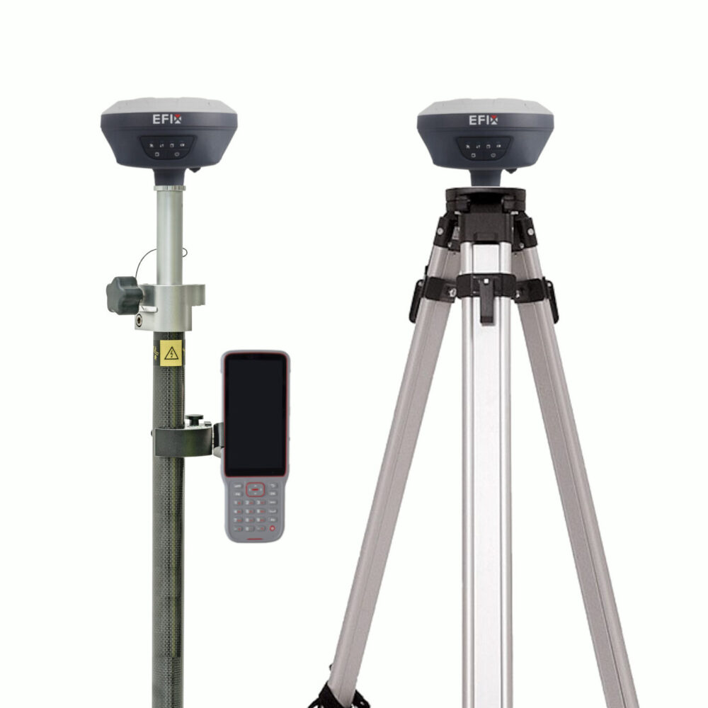
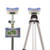
EFIX F7 Rover Base Set RTK GNSS Receiver with IMU Tilt
The EFIX F7 Rover Base Set is a compact RTK GNSS solution for surveyors, construction teams, engineers, GIS users and drone mapping professionals who need accurate positioning without depending only on an RTK network. With one receiver used as a base and the other as a rover, this set is practical for construction layout, topographic surveys, stakeout, control points, utility mapping and work in remote areas.
The EFIX F7 combines multi-constellation GNSS tracking, integrated IMU tilt compensation and an internal UHF radio in a lightweight, rugged receiver. The tilt compensation helps measure points faster when the pole cannot be kept perfectly level, while the base-rover setup gives field crews more independence on sites with limited mobile internet or no available correction service.
EFIX F7 Rover Base Set Highlights
| Receiver Setup | Complete rover and base RTK GNSS set |
|---|---|
| GNSS Tracking | GPS, GLONASS, Galileo, BeiDou and QZSS |
| IMU Tilt Compensation | Calibration-free IMU for faster pole-tilt measurements |
| RTK Accuracy | 8 mm + 1 ppm horizontal, 15 mm + 1 ppm vertical |
| Internal UHF Radio | 430–470 MHz radio for local base-rover corrections |
| Rugged Design | IP67 protected housing with 2 m pole-drop resistance |
Valued customers:


Find RTK Networks
Search NTRIP providers and connect to reliable RTK correction services.
Description
EFIX F7 Rover Base Set for independent RTK fieldwork
The EFIX F7 Rover Base Set is built for professionals who need reliable centimetre-level GNSS positioning on construction sites, survey projects, infrastructure work and mapping jobs. The set gives you a complete base and rover workflow, allowing one EFIX F7 receiver to transmit corrections from a known point while the second receiver is used in the field as the rover.
This makes the system especially useful when you work outside reliable RTK network coverage, on private sites, in rural areas or in locations where mobile internet is not stable enough for NTRIP corrections. Instead of relying only on a network service, the local base station provides correction data directly to the rover using the integrated UHF radio.
Made for surveyors, construction crews, GIS teams and drone pilots
The EFIX F7 Rover Base Set is suitable for a wide range of field users. Land surveyors can use it for topographic surveys, control points, stakeout and as-built measurements. Construction teams can use it for site layout, checking positions, road work, earthworks preparation and general measurement tasks around the jobsite.
GIS professionals can use the system to collect accurate asset positions for utilities, infrastructure, boundaries and mapping databases. Drone pilots can use the rover to measure ground control points for photogrammetry or LiDAR projects, helping improve the accuracy and consistency of mapping deliverables.
IMU tilt compensation for faster point measurement
The EFIX F7 includes an integrated IMU for pole-tilt compensation. In practical fieldwork, this means the operator does not always need to hold the pole perfectly vertical before recording a point. This is helpful when measuring close to fences, walls, kerbs, trenches, stockpiles, road edges or other obstacles where standing directly above the point is difficult or unsafe.
For stakeout and high-volume point collection, tilt compensation helps reduce time spent carefully levelling the pole for every shot. Crews can move more naturally across the site while still following good GNSS practice and checking measurement quality in the field software.
Multi-constellation GNSS for stable positioning
The EFIX F7 tracks multiple satellite constellations including GPS, GLONASS, Galileo, BeiDou and QZSS. In real working conditions, this gives the receiver access to more satellites, which can help maintain a stable RTK solution when the sky view is partly limited by buildings, trees, slopes, machinery or other jobsite obstructions.
With suitable corrections and good field conditions, the receiver is designed for centimetre-level RTK accuracy. It can also support static and post-processing workflows, giving surveyors more flexibility when real-time corrections are not the best option for a project.
Internal UHF radio for base and rover workflows
The integrated UHF radio makes the EFIX F7 Rover Base Set a practical choice for local RTK correction setups. The base receiver can send correction data to the rover without requiring mobile internet at every point on the site. This is useful for construction sites, quarries, farms, road projects and remote survey areas where network RTK coverage may be limited.
The receiver also supports common correction and data formats used in professional GNSS workflows, including RTCM, CMR, NMEA and RINEX. This helps the EFIX F7 fit into existing survey and mapping processes with compatible controllers, field software and processing tools.
Compact and rugged for daily outdoor use
The EFIX F7 is a compact, lightweight GNSS receiver designed for regular field use. Its IP67-rated housing protects against dust and water, while the receiver is specified to withstand a 2 metre pole drop. This makes it suitable for demanding outdoor work where equipment is exposed to rain, mud, dust, transport, vibration and busy construction environments.
The built-in battery supports long field sessions, and the USB Type-C connection can be used for charging, firmware updates and data transfer. Wi-Fi and Bluetooth support make it easier to connect with controllers, configure the receiver and manage field data.
Why buy the EFIX F7 Rover Base Set from Global GPS Systems
Choosing a rover and base set is not only about the receiver specifications. The complete setup needs to match your correction workflow, controller, software, region, radio requirements and the type of fieldwork you do every day. Global GPS Systems helps surveyors, construction professionals, GIS teams and mapping specialists choose GNSS equipment that fits their real working conditions.
With the EFIX F7 Rover Base Set, Global GPS Systems can support you with product selection, compatible accessories, RTK workflow advice and practical guidance for getting the system ready for the field. It is a strong option for buyers who want an affordable, compact and independent RTK GNSS setup for accurate outdoor measurement work.
Datasheets & Manuals
Datasheets and manuals
Specifications
EFIX F7 Rover Base Set Specifications
Product Overview
| Product Name | EFIX F7 Rover Base Set |
|---|---|
| Product Type | RTK GNSS rover and base surveying set |
| Receiver Model | EFIX F7 / F7+ GNSS receiver |
| Primary Applications | Land surveying, construction layout, topographic survey, stakeout, roadwork, earthworks, mapping and field data collection |
| Receiver Technology | Integrated GNSS + calibration-free IMU-RTK receiver |
| Base / Rover Use | Can be used as RTK rover or UHF RTK base, depending on field configuration |
| Field Software | EFIX eField Android surveying software |
| Data Collector | EFIX FC2 handheld field controller |
GNSS Performance
| GNSS Channels | 1608 channels |
|---|---|
| GPS Signals | L1C/A, L2C, L2P(Y), L5 |
| GLONASS Signals | L1, L2 |
| Galileo Signals | E1, E5a, E5b, E6* |
| BeiDou Signals | B1I, B2I, B3I, B1C, B2a, B2b |
| QZSS Signals | L1, L2, L5, L6* |
| PPP Support | B2b-PPP |
| SBAS Support | L1, L2 |
| Positioning Rate | 1 Hz, 5 Hz and 10 Hz |
| GNSS Engine Features | Advanced RTK algorithm with adaptive anti-interference and multipath mitigation |
GNSS Accuracy
| Mode | Horizontal Accuracy | Vertical Accuracy |
|---|---|---|
| Real-Time Kinematic (RTK) | 8 mm + 1 ppm RMS | 15 mm + 1 ppm RMS |
| Post-Processing Kinematic (PPK) | 3 mm + 1 ppm RMS | 5 mm + 1 ppm RMS |
| Post-Processing Static | 2.5 mm + 0.5 ppm RMS | 5 mm + 0.5 ppm RMS |
| Code Differential | 0.4 m RMS | 0.8 m RMS |
| Autonomous | 1.5 m RMS | 3.0 m RMS |
RTK Initialization and Tilt Compensation
| RTK Initialization Time | < 10 s |
|---|---|
| RTK Initialization Reliability | > 99.9% |
| Tilt Sensor | Calibration-free IMU for pole-tilt compensation |
| Magnetic Disturbance Resistance | IMU tilt compensation is immune to magnetic disturbance |
| RTK Tilt Compensation Accuracy | Additional horizontal pole-tilt uncertainty typically less than 10 mm + 0.7 mm/° tilt |
| Tilt Angle Stated on Product Page | Up to 60° IMU tilt sensor |
| Productivity Benefit | Designed to reduce the need for precise pole plumbing during survey and stakeout work |
Time to First Fix
| Cold Start | < 45 s |
|---|---|
| Hot Start | < 10 s |
| Signal Re-Acquisition | < 1 s |
Receiver Communication and Data Recording
| Wi-Fi | 802.11 b/g/n, access point mode |
|---|---|
| Bluetooth | Bluetooth v4.1 |
| USB Port | 1 x USB Type-C port for data download, charging and firmware update |
| UHF Antenna Port | 1 x TNC female UHF antenna port |
| Data Storage | 8 GB high-speed internal memory |
| Web Configuration | Receiver can be configured through a web interface using Wi-Fi connection from a PC or smartphone |
| Computer Connection | USB Type-C connection supports logged data download to a computer |
Receiver Data Formats
| CMR | CMR input and output |
|---|---|
| RTCM | RTCM 2.x and RTCM 3.x input and output |
| NMEA | NMEA 0183 output |
| Static Data Formats | HCN, HRC and RINEX static formats |
| NTRIP | NTRIP Client through PDA / controller network |
Internal UHF Radio
| Radio Type | Standard internal Rx/Tx UHF radio |
|---|---|
| Frequency Range | 410 – 470 MHz |
| Transmit Power | 0.5 W and 1 W |
| Protocols | EFIX, Transparent, TT450, Satel* |
| Typical Range | 3 km typical |
| Maximum Range | Up to 8 km in optimal conditions |
| Link Rate | 9,600 bps |
Receiver Power
| Power Consumption | 2.2 W, depending on user settings |
|---|---|
| Internal Battery | Built-in non-removable Li-ion battery, 6,800 mAh |
| External Power | 5 V / 2 A |
| Charging Port | USB Type-C |
| RTK Rover Operating Time | Up to 24 h on internal battery |
| UHF RTK Base Operating Time | Up to 10.5 h on internal battery |
| Static Operating Time | Up to 25 h on internal battery |
| Power Adapter Input | 100 – 240 V AC |
Receiver Hardware and Rugged Design
| Dimensions | 119 mm x 119 mm x 85 mm / 4.7 in x 4.7 in x 3.3 in |
|---|---|
| Weight | 0.77 kg / 1.60 lb |
| Housing | Magnesium alloy housing |
| Ingress Protection | IP67 dust and waterproof, protected from temporary immersion to depth 1 m |
| Shock Resistance | Survives a 2 m pole drop |
| Humidity | 100% condensation |
| Front Panel | 4 status LEDs and 2 buttons |
| Status LEDs | Correction LED, satellite LED, static LED and power LED |
| Mounting Thread | 5/8-11 threaded insert |
Receiver Environmental Specifications
| Operating Temperature | -40°C to +65°C / -40°F to +149°F |
|---|---|
| Storage Temperature | -40°C to +85°C / -40°F to +185°F |
| Certifications | CE; MIL-STD-810H |
EFIX FC2 Data Collector – System
| Controller Model | EFIX FC2 |
|---|---|
| Product Type | Handheld data collector / field controller |
| Operating System | Android-based field controller; available documentation lists Android 8.1 and newer configuration notes list Android 10 |
| Processor | MediaTek MT6765 octa-core processor |
| CPU Configuration | 4 cores at 2.3 GHz + 4 cores at 1.8 GHz |
| RAM | 4 GB |
| Internal Storage | 64 GB ROM |
| External Storage | Hot-swappable microSD card support up to 128 GB |
EFIX FC2 Data Collector – Display and Input
| Display Size | 5.5 inch |
|---|---|
| Display Type | HD+ capacitive multi-touch screen |
| Resolution | 1440 x 720 pixels |
| Brightness | 600 cd/m² typical |
| Outdoor Visibility | Sunlight-readable display |
| Touch Operation | Supports stylus, gloves and wet-hand operation |
| Keyboard | Alphanumeric keyboard |
| Shortcut Buttons | Survey hotkey side button and app shortcut button |
EFIX FC2 Data Collector – Communication
| Mobile Network Support | Integrated 2G / 3G / 4G modem |
|---|---|
| SIM Card | Nano-SIM |
| Wi-Fi | IEEE 802.11 a/b/g/n/ac/r, dual-band 2.4 GHz / 5 GHz |
| Bluetooth | Bluetooth 5.0 + BLE |
| NFC | Supported |
| USB | USB Type-C with OTG support |
| Network Sharing | Wi-Fi hotspot, USB shared network and Bluetooth shared network functions |
EFIX FC2 Mobile Network Bands
| Network Type | Supported Bands / Standards |
|---|---|
| 4G LTE FDD | B1 / B2 / B3 / B4 / B5 / B7 / B8 / B12 / B17 / B20 / B28AB |
| 4G LTE TDD | B34 / B38 / B39 / B40 / B41 |
| 3G WCDMA | B1 / B2 / B4 / B5 / B8 |
| CDMA EVDO | BC0 |
| 2G GSM | 850 / 900 / 1800 / 1900 MHz |
| EDGE | DL / UL |
EFIX FC2 Data Collector – Camera, Sensors and Battery
| Rear Camera | 8 MP rear camera with auto-focus and integrated flashlight; some earlier documentation lists 13 MP |
|---|---|
| Sensors | G-sensor, proximity sensor, light sensor, E-compass and gyroscope |
| Battery Type | Built-in lithium-ion battery |
| Battery Capacity | 8,000 mAh, 3.8 V; some earlier documentation lists 6,500 mAh |
| Operating Time | Up to 14 hours, depending on operating temperature and usage conditions |
| Charging Time | Approximately 4 hours typical |
EFIX FC2 Data Collector – Rugged and Physical Specifications
| Ingress Protection | IP67 |
|---|---|
| Dust Protection | Protected against dust ingress according to IP67 rating |
| Water Protection | Water-resistant according to IP67 rating |
| Shock Resistance | Survives 2 m / 6.5 ft fall onto concrete |
| Dimensions | 225 mm x 80 mm x 17.0 mm / 8.86 in x 3.15 in x 0.67 in |
| Weight | 400 g / 0.88 lb |
| Operating Temperature | -30°C to +60°C / -22°F to +140°F |
| Storage Temperature | -40°C to +70°C / -40°F to +185°F |
| Certifications | CE, FCC, MIL-STD-810H, RoHS, WPC |
EFIX eField Software – Survey Workflows
| Software Platform | Android-based GNSS surveying software |
|---|---|
| Supported Measurement Workflows | Static, RTK and PPK measurement workflows |
| Point Measurement Methods | Topographic point, control point, quick point, continuous point, offset point, corner point and specialized field workflows |
| Stakeout Functions | Point stakeout, line and arc stakeout, surface stakeout, sideslope stakeout, foundation stakeout, visual stakeout and road stakeout |
| Construction Layout | Supports setout of points, lines, arcs, surfaces, foundations and imported design data with compatible equipment |
| GNSS Status Display | Displays receiver battery status, satellite information and solution status |
| GIS Attribute Collection | Supports user-defined GIS attributes with pictures, videos and voice notes |
| Online and Offline Maps | Supports online map sources and offline background maps including CAD, GIS and raster files |
EFIX eField Software – Road, Pipeline and Total Station Workflows
| Road Survey Functions | Horizontal and vertical alignment, cross-sections, slopes, user-defined structures and road stakeout workflows |
|---|---|
| Road Design Import | LandXML road design elements and DXF polylines as road centerlines |
| Pipeline Survey | Pipeline survey workflow with GNSS receiver data and compatible pipeline detector data |
| Pipeline Export Formats | SHP and CSV |
| Total Station Workflows | Total station survey, point stakeout, line stakeout, surface stakeout and road stakeout where compatible instrument and connection method allow |
| Resection / Free Station | Supported |
| Backsight Methods | Backsight to known point and backsight by azimuth |
EFIX eField Software – Coordinate System and Localization
| Coordinate System Management | Supported |
|---|---|
| Ellipsoid Settings | Supported |
| Projection Settings | Supported |
| Datum Transformation | Supported |
| Horizontal Adjustment | Supported |
| Vertical Adjustment | Supported |
| Geoid File | Supported in project setup |
| Site Calibration | Supported |
| Base Shift | Supported |
| CORS Shift | Supported |
| Single Point Localization | Supported |
EFIX eField Software – Import Formats
| Point Import | Points and points-to-stakeout import supported |
|---|---|
| Text / Point File Formats | CSV, DAT, XLSX, XLS and TXT |
| Reference Map Import | DXF, DWG, SHP, KML, KMZ and XML |
| 3D CAD Import | 3D DXF |
| Reference Point Import | CSV fixed format |
| Lines / Arcs Import | LNS, PXY and KOF |
| Code / Code Library Import | CSV, XML, CXL, FCL, FXL and MXL |
| Background Image Import | TIF, TIFF, JPG, MBTILES, JMTILES / Jmtiles and WFSDB |
| Coordinate System Import | DC, JXL, CAL, LOK and CRD |
| Site Calibration Import | CAL, LOC, COT and TXT |
| Carlson File Support | CRD / CRDB import supported |
EFIX eField Software – Export Formats and Reports
| CAD Export | DWG and DXF |
|---|---|
| GIS Export | SHP, KML and KMZ |
| Text / Spreadsheet Export | CSV, DAT, TXT and XLSX |
| Raw Data Export | RAW supported |
| HTML Export | Supported |
| Survey Reports | HTML and CSV report workflows supported |
| Stakeout Reports | Point stakeout report supported |
| Additional Reports | Hydro survey, measurement, area and verified survey reports supported |
| Star*Net Export | DAT and GPS report formats |
| Trimble JXL Export | JXL supported |
| MicroStation Export | TXT format |
| Surface Stakeout Export | CSV, TXT and DAT |
EFIX eField Software – Cloud and Field Tools
| Project Backup and Restore | Local project backup and cloud restore supported |
|---|---|
| Cloud Upload / Download | Projects, coordinate systems, work modes and related data |
| Project Sharing | Sharing code support for projects, coordinate systems, points and base maps |
| Collaborative Work | Supported |
| Remote Assistance | Supported |
| Field Calculations | Map adjustment, volumes, inverse calculation, plot deed, transformation, area subdivision and area calculation |
| Geometry Tools | Point-to-line distance, offset distance, deflection, rotation, intersection, bisect angle, divide line and tangent point |
| General Tools | Angle conversion, parameter calculation, calculator and ruler |
Package / Included Items
| Item | Quantity | Notes |
|---|---|---|
| EFIX F7 GNSS Receiver | 2 | One receiver typically configured as rover and one as base for rover-base set operation |
| EFIX FC2 Data Collector | 1 | Handheld Android field controller for survey data collection and receiver control |
| EFIX eField Software | 1 | Android surveying software for GNSS survey, stakeout and field workflows |
| UHF Bar Antenna, 410 – 470 MHz | Included | For internal UHF radio communication |
| USB Type-C Cable | Included | For charging, data download and firmware update |
| Power Adapter | Included | For receiver charging through USB Type-C cable |
| Survey Pole / 2 m Range Pole with Bag | Included | For rover operation |
| Data Collector Bracket | Included | For mounting the controller to the survey pole |
| Tripod | Included | For base station setup |
| Tribrach | Included | For stable base station mounting |
| Tribrach Adapter | Included | Listed in EFIX F7 basic supply accessories |
| Auxiliary H.I. Tool | Included | For height measurement workflow |
| Transport Hard Case | Included | For storage and transport of receiver kit components |
Configuration and Compatibility Notes
| Accuracy Conditions | Accuracy and reliability depend on open sky conditions, low multipath, optimal GNSS geometry, atmospheric conditions and recommended GNSS practices |
|---|---|
| Satellite Service Notes | Some Galileo E6 and QZSS L6 functionality may depend on service availability and firmware support |
| Radio Licensing | UHF radio operation may require authorization or licensing depending on country or region |
| Battery Runtime Note | Battery life depends on operating temperature, settings and field usage |
| Controller Configuration Note | FC2 specifications such as Android version, battery capacity and camera resolution may vary by production configuration |
| Software Compatibility Note | Some eField workflows depend on compatible receiver model, instrument model, firmware, license, enabled module and connection method |
Specifications and package contents may vary by configuration, region or manufacturer update. Always check the current configuration before ordering.
FAQ
EFIX F7 Rover Base Set FAQ
Product Use and Applications
What is the EFIX F7 Rover Base Set used for?
The EFIX F7 Rover Base Set is used for high-accuracy GNSS surveying, construction layout, stakeout, mapping, roadwork, utility surveys, control point measurement and other field positioning tasks that require reliable RTK results.
Who is the EFIX F7 Rover Base Set designed for?
It is designed for land surveyors, civil engineers, construction contractors, GIS teams, mapping professionals, infrastructure companies, utility crews and drone mapping users who need accurate field measurements.
What is the difference between a rover set and a rover-base set?
A rover set normally uses one receiver with correction data from an RTK network or NTRIP service. A rover-base set includes two receivers: one fixed base station and one mobile rover, allowing users to work independently from local correction networks.
When should I choose a rover-base set instead of a rover-only set?
A rover-base set is useful when you work in remote areas, on private construction sites, in locations with poor mobile internet, or in regions without reliable RTK network coverage.
Can the EFIX F7 Rover Base Set be used for construction layout?
Yes. The EFIX F7 Rover Base Set can be used for construction stakeout, site layout, roadwork, earthworks preparation and checking positions on a job site when used with suitable field software and correct survey procedures.
Can GIS and mapping teams use the EFIX F7?
Yes. GIS and mapping teams can use the EFIX F7 for accurate asset collection, utility mapping, infrastructure documentation, environmental mapping and other high-precision data collection workflows.
Accuracy and GNSS Performance
How accurate is the EFIX F7 Rover Base Set?
The EFIX F7 is built for centimetre-level RTK positioning. Actual accuracy depends on satellite visibility, correction quality, site conditions, antenna setup, multipath, atmospheric conditions and correct field procedures.
Which satellite constellations does the EFIX F7 support?
The EFIX F7 supports multiple GNSS constellations, including GPS, GLONASS, Galileo, BeiDou and QZSS. This helps improve satellite availability and positioning reliability in professional fieldwork.
How many GNSS channels does the EFIX F7 have?
The EFIX F7 product information lists 1608 GNSS channels, allowing the receiver to track many satellite signals for stable RTK positioning and survey performance.
What can affect EFIX F7 accuracy in the field?
Accuracy can be affected by trees, buildings, reflective surfaces, poor satellite geometry, weak correction data, incorrect antenna height, unstable base setup, poor radio connection or incorrect project settings.
Can the EFIX F7 be used for static or PPK surveying?
Yes. The EFIX F7 can support static and post-processing workflows depending on the project setup, field procedure, data format and processing software used.
Does the EFIX F7 support RINEX data?
Yes. The EFIX F7 supports static/raw data workflows including RINEX formats, making it suitable for post-processing tasks when RTK is not the preferred method.
IMU Tilt, Base-Rover Workflow and Connectivity
Does the EFIX F7 have IMU tilt compensation?
Yes. The EFIX F7 includes IMU tilt compensation, which helps measure points when the survey pole is not perfectly vertical.
Does the EFIX F7 IMU need calibration?
The EFIX F7 is listed with a calibration-free IMU, helping users start work faster and reducing setup steps during normal field operation.
Why is IMU tilt compensation useful?
IMU tilt compensation helps users measure hard-to-reach points near walls, fences, trenches, kerbs, slopes, stockpiles or other obstacles without spending extra time perfectly levelling the pole for every measurement.
Does the EFIX F7 have an internal UHF radio?
Yes. The EFIX F7 includes an internal UHF radio for transmitting or receiving RTK corrections in base-rover workflows.
What is the UHF radio range of the EFIX F7?
The typical UHF radio range is around 3 km, with longer range possible under optimal open-field conditions. Actual range depends on terrain, antenna setup, radio settings, interference and line of sight.
Can the EFIX F7 use NTRIP corrections?
Yes. The EFIX F7 can be used with NTRIP correction workflows through a compatible controller or field software connection, depending on the correction service and setup.
Does the EFIX F7 have an internal internet modem?
No. The EFIX F7 is listed without an internal internet modem. For network RTK workflows, correction data is typically received through the connected controller, data collector or another internet-enabled device.
Software, Accessories and Field Durability
What software is used with the EFIX F7 Rover Base Set?
The EFIX F7 Rover Base Set is commonly used with EFIX eField surveying software for survey, stakeout, mapping and engineering workflows.
What accessories are included with the EFIX F7 Rover Base Set?
The set includes essential field accessories such as the EFIX FC2 data collector, eField software, surveying pole, data collector bracket, tripod, tribrach and adapter. Package contents can vary by configuration, so the current kit should always be checked before ordering.
Can the EFIX F7 Rover Base Set be customised?
Yes. The set can be adapted for different workflows, such as using a tablet instead of the included controller or changing software and accessories depending on project requirements.
Is the EFIX F7 waterproof and dustproof?
Yes. The EFIX F7 has an IP67 rating, which means it is protected against dust and temporary water immersion under specified conditions.
How rugged is the EFIX F7 for field use?
The EFIX F7 is designed for demanding outdoor work, with a rugged housing and resistance to a 2 m pole drop, making it suitable for construction sites, roads, survey projects and other field environments.
How long does the EFIX F7 battery last?
Battery life depends on receiver settings, temperature, radio use and workflow. Product information lists long operating time for RTK rover and static work, and the receiver supports USB-C charging for easier field power management.
Reviews (0)
Only logged in customers who have purchased this product may leave a review.
Reviews
There are no reviews yet