
 GPS & GNSS
 Lidar scanning
 Total Station

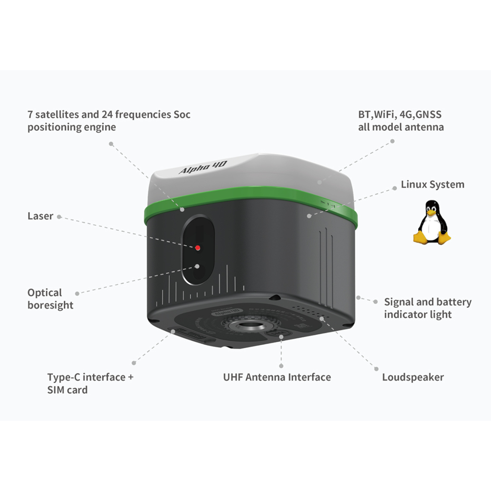



Alpha 40 Rover Base Set with Laser IMU and AR Camera
This product is available
Get the best price for your setup
Contact our experts for the best possible price and configuration.
The Alpha 40 Rover Base Set is a complete RTK GNSS system for surveyors, construction teams, engineers, GIS users and drone mapping professionals who need their own rover and base workflow. The set combines two Alpha 40 optic-electric GNSS receivers with field-ready accessories, allowing one receiver to work as the base station while the second receiver is used as the rover.
This setup is ideal for projects where you do not want to rely only on an external correction network. With laser measurement, IMU tilt compensation, AR-guided stakeout, 1408-channel GNSS tracking, 4G connectivity and a built-in 2W UHF/LoRa radio, the Alpha 40 Rover Base Set is built for accurate measuring, setting out, CAD mapping, road work, earthworks, drone base station use and everyday site positioning.
Alpha 40 Rover Base Set Highlights
| RTK Set Configuration | Two Alpha 40 GNSS receivers for rover and base station use |
|---|---|
| Laser Measurement | Up to 50 m laser range with ±1 mm laser ranging accuracy |
| IMU Tilt Compensation | 0° to 60° tilt compensation for faster pole measurements |
| AR Stakeout | Dual AR camera guidance for remote and near-view point finding |
| GNSS Tracking | 1408 channels with GPS, BDS, GLONASS, Galileo, QZSS, SBAS and NavIC |
| Radio and Connectivity | 2W UHF/LoRa radio, 410–470 MHz, 4G, WiFi, Bluetooth 5.2 and Type-C |


Valued customers:










Find RTK Networks
Search NTRIP providers and connect to reliable RTK correction services.
Description
Alpha 40 Rover Base Set for Professional RTK GNSS Surveying
The Alpha 40 Rover Base Set is a complete RTK GNSS solution for users who need a reliable base and rover setup in the field. Instead of working with only one receiver or depending fully on a correction network, this set gives surveyors, construction crews, engineers, GIS teams and drone pilots a complete two-receiver workflow for accurate positioning on a wide range of job sites.
One Alpha 40 receiver can be set up as the base station in a known or measured position, while the second receiver is used as the rover for measuring points, staking out designs and collecting field data. This makes the set especially useful for construction sites, remote survey areas, infrastructure projects, solar farms, road works, earthworks and drone mapping jobs where consistent RTK corrections are needed throughout the day.
Complete Rover and Base Workflow
A rover and base set is a practical choice when the job site does not have reliable mobile network coverage, when local control is required, or when the user wants to work independently from an external NTRIP correction service. The Alpha 40 base receiver sends correction data to the rover using the integrated radio system, allowing the field crew to work with a controlled local RTK setup.
For surveyors and engineers, this is useful on topographic surveys, control point work, boundary support measurements, construction layout, road projects and larger site surveys. For construction workers, it provides a straightforward way to set out points, check levels, measure site features and work from design data without needing a separate total station for every task.
Laser Measurement for Difficult and Unsafe Points
The Alpha 40 includes laser measurement for points that are difficult, unsafe or simply inconvenient to reach with a survey pole. In real fieldwork, this can include building corners, façades, fences, ditches, slopes, road edges, trenches, water edges, overhead points and hidden points where placing the pole directly on the target is not practical.
By combining GNSS positioning, inertial measurement and laser ranging, the Alpha 40 helps users measure selected offset points without always standing directly on them. This can save time on detail surveys and improve safety when working near traffic, excavations, water, obstacles or restricted areas.
IMU Tilt Compensation for Faster Measurements
The Alpha 40 supports IMU tilt compensation up to 60°. This allows the rover pole to be tilted while still recording accurate measurements within the supported range. For everyday field crews, this means less time spent carefully levelling the pole at every point and more flexibility when working close to walls, fences, machines, vehicles, trees or uneven ground.
Tilt compensation is especially useful in construction and engineering work, where the point to be measured is often close to an obstruction. It also helps less experienced users work more confidently, because the receiver is more forgiving during normal pole handling.
AR Guided Stakeout for Easier Point Finding
The Alpha 40 uses dual AR camera guidance to make stakeout work easier to understand in the field. Instead of looking only at arrows and numbers on the controller, users can see the stakeout direction and target point in a real-world camera view. This helps crews move toward the design point more naturally, especially on busy construction sites or open terrain where visual orientation can be difficult.
The system supports remote AR-guided stakeout and near-view AR-guided stakeout. This means the user can navigate toward the point from further away, then switch to closer visual guidance when approaching the final position. For road layout, solar panel layout, foundation work, utility marking and general construction setting out, this makes the workflow clearer and faster.
Multi Constellation GNSS Performance
The Alpha 40 tracks GPS, BDS, GLONASS, Galileo, QZSS, SBAS and NavIC signals with 1408 channels. In practical terms, this gives the receiver access to more satellite signals during the working day, which helps maintain reliable positioning in many survey and construction environments.
The receiver supports RTK accuracy for field measurement and can be used in base-rover mode, rover mode with correction services, and drone base station workflows. This flexibility makes the Alpha 40 Rover Base Set useful for teams that handle different project types throughout the year.
Built in UHF and LoRa Radio
The integrated 2W UHF radio supports the 410–470 MHz frequency range and LoRa communication. This allows the base station to transmit corrections to the rover without needing mobile internet on every job. The radio system supports common RTK communication protocols, which helps when working with different site setups or mixed equipment environments.
For larger or more demanding projects, the receiver also includes an external radio interface. This gives survey companies and contractors more flexibility when a specific communication range or external radio setup is required.
DiMap Pro Field Software for Survey and Construction Tasks
The Alpha 40 Rover Base Set works with DiMap Pro field software. DiMap Pro supports point measurement, detail survey, control point measurement, point stakeout, CAD mapping, road design stakeout, power survey, line measurement, surface measurement, curve stakeout, tower base stakeout, photovoltaic stakeout and earthwork measurement.
For users working from drawings, the software can handle large CAD files, multiple layers, map backgrounds, WMS map configuration, file sharing, field calculations and measurement correction tools. This is useful for surveyors, site engineers and construction layout teams who need to move between design data and field measurements during the same job.
Alpha Controller for Field Use
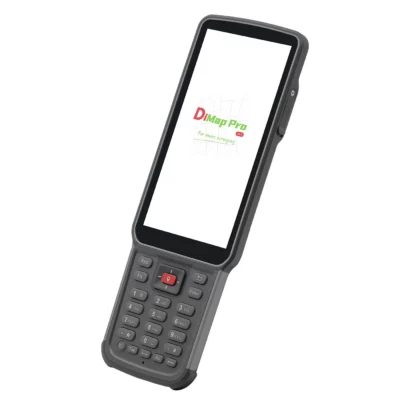
The set includes the Alpha Controller, designed for outdoor surveying and construction use. It has a 5.5-inch screen, 8-core processing, 4 GB RAM, 64 GB storage and IP67 protection. Rainy mode and glove mode help make the controller easier to operate in practical job site conditions.
For field teams, the controller and DiMap Pro combination keeps the workflow simple: connect the receiver, start the project, load or create the required data, measure points and stake out designs from one handheld device.
Useful for Drone Mapping and UAV Workflows
The Alpha 40 can also support drone base station workflows. For drone pilots and mapping companies, a reliable GNSS base can improve project control and help connect aerial data with accurate ground reference measurements. This is useful for photogrammetry, LiDAR support, site mapping, stockpile measurement, earthworks and engineering documentation.
Because the Alpha 40 Rover Base Set includes two receivers, one unit can be used as the base while the other remains available for ground control points, check points, site measurements or layout work.
Rugged and Portable for Daily Fieldwork
The Alpha 40 receiver is compact and lightweight, with a 100 mm × 100 mm × 80 mm body and a weight of around 650 g. The IP67-rated housing helps protect it against dust and water, while the receiver is designed for outdoor working conditions from construction sites to open survey areas.
The battery performance supports full working days depending on the selected mode, with different operating times for NTRIP, radio receiving and radio transmitting. For field crews, this helps reduce downtime and keeps the equipment practical for daily use.
Who Should Choose the Alpha 40 Rover Base Set?
The Alpha 40 Rover Base Set is suitable for professionals who want a complete RTK setup instead of a single rover. It is a strong choice for land surveyors, construction layout teams, civil engineers, road contractors, solar farm installers, utility mapping teams, GIS workers, drone mapping companies and contractors working in areas where correction network access may not always be available.
It is also useful for companies that want one flexible GNSS package for multiple workflows. The same set can support base-rover surveying, construction stakeout, CAD mapping, drone base station work, GIS data collection and general site measurement.
Buying from Global GPS Systems
Global GPS Systems supplies professional GNSS, surveying and construction measurement equipment for users who need practical advice and reliable support. When buying the Alpha 40 Rover Base Set from Global GPS Systems, customers can get help selecting the right configuration for their workflow, including rover and base setup, controller use, radio setup, correction service compatibility, drone base station use and field software requirements.
Datasheets & Manuals
Datasheets and manuals
Datasheets
Specifications
Alpha 40 Rover & Base Set Specifications
Product Overview
| Product Name | Alpha 40 Rover & Base Set |
|---|---|
| Product Type | Professional GNSS RTK rover and base station set |
| Receiver Model | Alpha 40 |
| Controller Model | Alpha B55 / Alpha Controller |
| Brand | Alpha Surveying |
| Product Category | GPS & GNSS; GPS Rover-Base Sets |
| Primary Applications | Professional surveying, construction layout, mapping, topographic surveys, RTK positioning, static control measurement, CAD mapping, drone base station workflows and field data collection |
| System Configuration | Coordinated rover and base station setup with GNSS receiver, controller, field software, pole, bracket, antenna and carrying case |
| Core Technologies | Multi-constellation GNSS, RTK, IMU tilt compensation, laser measurement, optical calibration, AR staking-out, 4G, Wi-Fi, Bluetooth and UHF radio communication |
GNSS Receiver
| Receiver Type | Optic-electric RTK GNSS receiver |
|---|---|
| GNSS Channels | 1408 channels |
| Supported Satellite Systems | GPS, BDS / BeiDou, GLONASS, Galileo, QZSS, SBAS and NavIC |
| Tracked Satellite/Frequency Capability | 7 satellite systems and 24 frequencies |
| Operating System | Linux |
| Receiver Memory | 32 GB |
| Data Recording Formats | DAT, RINEX |
| Update Rate | 200 Hz |
GNSS Signal Tracking
| GPS | L1C/A, L1C, L2C, L2P, L5 |
|---|---|
| BeiDou / BDS | B1I, B2I, B3I, B1C, B2a, B2b |
| GLONASS | G1, G2, G3 |
| Galileo | E1, E5a, E5b, E6 |
| QZSS | L1C/A, L1C, L2C, L5 |
| SBAS | L1 |
| NavIC | L5 |
Positioning Accuracy
| Static Accuracy – Horizontal | ±(2.5 + 0.5 × 10⁻⁶D) mm |
|---|---|
| Static Accuracy – Vertical | ±(5 + 0.5 × 10⁻⁶D) mm |
| RTK Accuracy – Horizontal | ±(8 + 1 × 10⁻⁶D) mm |
| RTK Accuracy – Vertical | ±(15 + 1 × 10⁻⁶D) mm |
| Real-Scene Point Finding Accuracy | 1 cm |
| Non-Contact Measurement Accuracy | 3 cm to 5 cm at 10 m distance |
Tilt Compensation and IMU
| IMU / INS Type | Military-grade professional inertial navigation system |
|---|---|
| Inertial Navigation Accuracy | 0.015° |
| Tilt Compensation Accuracy | ±(8 + 0.3 × TILT) mm |
| Compensation Angle | 0° to 60° |
| Tilt Accuracy at 60° Inclination | 2 cm accuracy |
| Initialization | No initialization required; enters inertial navigation mode after walking a few steps |
| Sensor Fusion | GNSS positioning, INS, magnetometer data, temperature compensation algorithms and laser ranging |
Laser Measurement and Optical Calibration
| Laser Measurement Range | 50 m |
|---|---|
| Laser Measurement Accuracy | ±1 mm |
| Measurement Capability | 360° non-contact measurement |
| Optical Calibration | Crosshair aiming point synchronized with the actual laser measurement target |
| Outdoor Laser Visibility Support | Designed to maintain visible positioning when the laser spot is difficult to see under intense sunlight |
| Typical Laser Measurement Scenarios | Cadastral hidden points, aerial points, underground points and inaccessible points |
AR Staking-Out
| AR Guidance | Dual AR staking-out guidance |
|---|---|
| Remote AR Staking-Out | Supported |
| Proximal AR Staking-Out | Supported |
| Near-View AR Switching Distance | Approximately 5 m; adjustable |
| Real-Scene Display | 360° real-time display under strong outdoor light |
| Design Data Overlay | Combines design data with real-world images for field staking-out guidance |
| Lens / Imaging | Image-level lens with small optical distortion and professional algorithms |
Radio Communication
| Integrated Radio Power | 2 W |
|---|---|
| Radio Type | Dual-mode transceiver with full-power compatible radio and LoRa low-power long-range transceiver |
| Frequency Range | 410 MHz to 470 MHz |
| Operation Mode | Transceiver |
| Communication Protocols | TRIMTALK 450S, TRIMMARK III, SOUTH9600, SOUTH19200, SATEL9600, SATEL19200, Transparent, LoRa |
| Estimated LoRa Range | Up to 5 km under suitable open conditions |
| External Radio Support | Serial port supports connection to external high-power radios |
| UHF Antenna Interface | SMA radio UHF antenna interface |
| Base Station Setup Guidance | Base station should be positioned in a relatively high and open area for best radio performance |
Wireless and Network Connectivity
| Cellular Network | 4G |
|---|---|
| Onboard 4G | Supported |
| 4G Card Slot | Supported |
| Wi-Fi | 802.11 a/b/g/n/ac |
| Bluetooth | Bluetooth 5.2 BR/EDR + LE dual-mode Bluetooth |
| Web Interface | WebUI supported |
| PPP | Supported |
| Antenna Integration | Bluetooth, Wi-Fi, 4G and GNSS full-mode antenna |
Ports, Indicators and Audio
| Type-C Interface | Charging, data transmission and external port connection |
|---|---|
| SMA Interface | Radio UHF antenna connection |
| Indicator Lights | Satellite, datalink, Bluetooth and battery lights |
| Battery Level Display | Supported |
| Loudspeaker | Supported |
| Voice Prompts | Intelligent voice supported |
Receiver Power and Battery
| Input Voltage | 9 V to 20 V power delivery |
|---|---|
| Battery Capacity | 37 Wh |
| Working Time – NTRIP | Up to 18 hours |
| Working Time – Radio Receiving | Up to 15 hours |
| Working Time – Radio Transmitting | Up to 8 hours |
| Charging Interface | USB Type-C |
| Long Battery Life | Supported |
Receiver Physical Specifications
| Receiver Dimensions | 100 mm × 100 mm × 80 mm, excluding 5/8-inch pin interface |
|---|---|
| Receiver Weight | 650 g |
| Housing Material | Aluminum-magnesium alloy housing |
| Cover | Nano wave-transparent cover |
| Internal Frame | Shielding middle frame |
| Pole Configuration | 1.8 m lightweight carbon fiber portable pole |
| Retracted Pole Length | 75 cm |
| Instrument Box Configuration | 22 cm high instrument box configuration |
Receiver Environmental Specifications
| Operating Temperature | -30°C to +70°C |
|---|---|
| Storage Temperature | -40°C to +80°C |
| Water and Dust Protection | IP67 |
| Shock Resistance | 1.8 m drop resistance on hard ground at normal temperature |
| Humidity | Up to 100% |
Alpha B55 Controller Platform
| Controller Type | Professional PDA collector / field controller |
|---|---|
| Display | 5.5-inch display, 720 × 1440 resolution |
| Processor | 8-core 2.0 GHz processor |
| Operating System | Android 11 |
| Memory and Storage | 4 GB RAM + 64 GB internal storage |
| Rear Camera | 13 megapixel autofocus camera |
| Touchscreen | 10-point touch support |
| Field Modes | Rainy mode and glove mode supported |
Alpha B55 Controller Connectivity
| WLAN | IEEE 802.11 a/b/g/n/ac, 2.4 GHz / 5 GHz |
|---|---|
| Bluetooth | Bluetooth 5.0 BLE |
| NFC | ISO14443A/B and ISO15693 protocol support; 0 cm to 5 cm distance |
| FDD-LTE Bands | B1, B3, B5, B7, B8 |
| TDD-LTE Bands | B38, B39, B40, B41 |
| WCDMA Bands | B1, B2, B5, B8 |
| GSM Bands | B2, B3, B5, B8 |
| CDMA / EVDO Bands | BC0, BC1 |
| SIM Card Slot | Dual SIM |
| SD Card Slot | Supports up to 256 GB |
Alpha B55 Controller Power, Interfaces and Audio
| Battery | 3.7 V, 7700 mAh |
|---|---|
| Speaker | 95 dB ±3 |
| Microphone | 1 × MIC |
| USB Interface | USB Type-C |
| USB Functions | OTG and fast charging supported |
Alpha B55 Controller Physical and Environmental Specifications
| Controller Dimensions | 221 mm × 77.7 mm × 16 mm |
|---|---|
| Controller Weight | 335 g |
| Operating Temperature | -20°C to +55°C |
| Storage Temperature | -30°C to +70°C |
| Operating Humidity | 5% to 95% |
| Drop Resistance | 1.5 m drop resistance on hard ground |
| IP Protection | IP67 |
Field Software
| Field Software | DiMap Pro |
|---|---|
| Survey Functions | Point measurement, detailed measurement, control point measurement, point stakeout, CAD mapping, road design stakeout, power survey and elevation site control |
| Advanced Measurement Functions | Line measurement, surface measurement, curve stakeout, tower base stakeout, photovoltaic stakeout and earthwork measurement |
| CAD Engine | Supports smooth opening and running of files over 100 MB, loading more layers and complete drawing functions |
| Text and Format Support | Multiple text encoding formats, custom data decimal places and multiple angle formats |
| Map Support | Amap standard map, Amap satellite map, OpenStreetMap, WMS map configuration and map calibration |
| Data Sharing | Cloud sharing and file sharing supported |
| Workflow Tools | Encoding management, shortcut key customization, survey area import range preview, bias correction, background layer setting, tilt measurement accuracy check, function customization, post-measurement correction and built-in calculator |
| User Feedback | Voice broadcast and live feedback supported |
Drone Base Station and Integration
| Drone Base Station Function | Supported |
|---|---|
| Serial Port Customization | Supported |
| Unmanned System Integration | Supports positioning fusion for unmanned systems and laser radar workflows |
| Compatible Workflow Types | Smart terminals, optoelectronic products and unmanned systems |
Receiver Version Options
| Version | Camera Configuration | Notes |
|---|---|---|
| Laser with One-Camera | Single-camera laser configuration | Version option shown in Alpha 40 datasheet |
| Laser with Dual-Camera | Dual-camera laser configuration | Supports dual-camera AR workflow where configured |
Professional Set Package Contents
| Item | Quantity | Notes |
|---|---|---|
| Alpha 40 Receiver | 1 | Main GNSS RTK receiver for rover/base use |
| Radio Antenna | 1 | UHF radio antenna |
| Host Adapter | 1 | Receiver adapter |
| Host Cable | 1 | Receiver cable |
| Controller | 1 | Alpha B55 / Alpha Controller |
| Controller Adapter | 1 | Controller power adapter |
| Controller Cable | 1 | Controller cable |
| Centering Pole | 1 | Survey pole |
| Bracket | 1 | Controller or receiver mounting bracket |
| Instruction | 1 | Instruction document/manual |
| Carrying Case | 1 | Transport and storage case |
Alpha B55 Controller Package Contents
| Item | Quantity | Notes |
|---|---|---|
| PDA Collector | 1 | Alpha B55 controller |
| USB Cable | 1 | Controller USB cable |
| Adapter | 1 | Controller charging adapter |
Specifications and package contents may vary by configuration, region or manufacturer update. Always check the current configuration before ordering.
FAQ
Alpha 40 Rover & Base Set FAQ
Product Overview
What is the Alpha 40 Rover & Base Set?
The Alpha 40 Rover & Base Set is a complete professional RTK GNSS surveying system that combines an Alpha 40 rover, a base station, field controller, and DiMap Pro software. It is designed for accurate real-time positioning, surveying, construction layout, mapping, drone ground control, and infrastructure work.
Who is the Alpha 40 Rover & Base Set designed for?
This set is designed for land surveyors, construction professionals, civil engineers, mapping specialists, drone mapping teams, utility crews, road contractors, cadastral surveyors, infrastructure teams, and other professionals who need accurate GNSS measurements in the field.
What is the difference between a rover set and a rover-base set?
A rover set is typically used with an external RTK correction source, such as an RTK network. A rover-base set includes both the mobile rover and a local base station, allowing users to create their own RTK correction setup on site when network corrections are unavailable, unreliable, or not preferred.
When should I choose the Alpha 40 Rover & Base Set instead of a rover-only setup?
Choose the rover-base set when you want more control over your RTK corrections, work in remote areas, operate on large construction or infrastructure sites, need a local reference station, or do not want to depend only on mobile internet or RTK network coverage.
Which industries use the Alpha 40 Rover & Base Set?
The Alpha 40 Rover & Base Set is suitable for land surveying, construction, road building, civil engineering, GIS mapping, utility mapping, drone mapping, agriculture, photovoltaic layout, earthworks, infrastructure, cadastral work, and power line or tower stakeout.
Rover-Base RTK Workflow
How does the rover-base system work?
The base station is set up over a known or fixed reference point and transmits RTK correction data to the rover. The rover then uses those corrections while moving around the site to produce accurate real-time GNSS measurements.
Does the Alpha 40 Rover & Base Set need an RTK network subscription?
Not necessarily. Because the set includes a base station and rover, it can be used as a local RTK system without relying on an RTK network subscription. The rover can also be used with compatible NTRIP or RTK network corrections when available.
Can the Alpha 40 Rover & Base Set be used in remote areas?
Yes. The rover-base configuration is useful in remote areas because the local base station can provide corrections to the rover without depending only on mobile internet coverage. Radio range and performance depend on terrain, obstacles, antenna setup, and base station placement.
Where should the base station be placed?
For best results, the base station should be placed in a high, stable, and open area with good satellite visibility and minimal obstructions. A clear setup helps improve correction reliability and radio communication between the base and rover.
Can this set be used for both static and real-time measurements?
Yes. The Alpha 40 Rover & Base Set can support workflows such as static control measurements, real-time RTK positioning, control point establishment, construction layout, CAD stakeout, and field mapping tasks.
Can the Alpha 40 communicate by UHF radio?
Yes. The Alpha 40 includes a built-in UHF radio supporting the 410–470 MHz frequency range. This allows the base and rover to communicate using radio correction workflows where suitable and legally permitted.
Accuracy, GNSS and Measurement Features
What GNSS signals does the Alpha 40 support?
The Alpha 40 supports multi-constellation GNSS tracking, including GPS, GLONASS, Galileo, and BeiDou signals. Multi-constellation support helps improve satellite availability and positioning reliability during professional field work.
How many GNSS channels does the Alpha 40 have?
The Alpha 40 has 1408 GNSS channels. This allows the receiver to track a wide range of satellite signals for stable and accurate RTK positioning in suitable field conditions.
Does the Alpha 40 Rover & Base Set provide centimeter-level accuracy?
Yes. When properly configured with good satellite visibility, a stable base setup, and reliable correction transmission, the Alpha 40 Rover & Base Set is designed for centimeter-level RTK surveying and positioning workflows.
Does the Alpha 40 have IMU tilt compensation?
Yes. The Alpha 40 includes a 60° IMU tilt sensor, allowing users to measure points without keeping the pole perfectly vertical. This is useful near walls, fences, trenches, slopes, obstacles, and difficult-to-access points.
What is the laser measurement function used for?
Laser measurement allows users to measure points that are difficult, unsafe, or impossible to reach directly with the pole. It is useful for hidden points, aerial points, underground points, inaccessible points, and measurements across obstacles.
What is optical calibration on the Alpha 40?
Optical calibration helps align the aiming point with the actual laser measurement target. This improves confidence during laser-based measurement, especially in bright outdoor conditions where the laser spot may be difficult to see.
Software, Controller and Field Use
What software is included with the Alpha 40 Rover & Base Set?
The Alpha 40 Rover & Base Set is supplied with DiMap Pro field software. DiMap Pro supports professional GNSS tasks such as point measurement, detailed measurement, control point work, line and curve stakeout, surface stakeout, road design stakeout, power line stakeout, CAD mapping, photovoltaic surveys, and earthwork measurement.
Can the Alpha 40 Rover & Base Set be used for CAD stakeout?
Yes. With DiMap Pro, the system supports CAD-based field workflows, allowing users to load and work with CAD drawings during surveying and construction layout tasks.
What controller is used with the Alpha 40 Rover & Base Set?
The set includes an Alpha field controller designed for professional outdoor use. It has a 5.5-inch sunlight-readable touchscreen, an 8-core processor, 4GB RAM, 64GB storage, IP67-rated protection, and operating modes for rainy conditions and glove use.
Does the Alpha 40 support AR stakeout?
Yes. The Alpha 40 supports dual AR stakeout guidance, helping users visually navigate to stakeout points in the real-world view. This can make construction layout and point finding faster and easier in the field.
What connectivity options does the Alpha 40 support?
The Alpha 40 supports 4G, WiFi, Bluetooth, GNSS communication, UHF radio, LoRa communication, and Type-C connection. These options help support different RTK correction, controller, data transfer, and field communication workflows.
Is the Alpha 40 Rover & Base Set suitable for harsh field conditions?
Yes. The system is designed for professional outdoor surveying and construction environments. The receiver is compact and field-ready, while the controller includes IP67-rated protection for dust and water resistance.
Reviews (0)
Only logged in customers who have purchased this product may leave a review.


 GPS & GNSS
 Total Stations
 Data collectors
 Software
 Correction services
 Machine control
 External radio
 Lasers & levellers
 Marine
 Accessories
Reviews
There are no reviews yet