


Alpha 40 Rover Set RTK GNSS Receiver with Laser IMU and AR
The Alpha 40 Rover Set is a complete RTK GNSS rover package for surveyors, construction crews, engineers, GIS teams and drone mapping professionals who need accurate positioning in real field conditions. The set combines the Alpha 40 optic-electric GNSS receiver, Alpha Controller and DiMap Pro field software for point measurement, stakeout, CAD mapping, road work, earthworks and everyday site data collection.
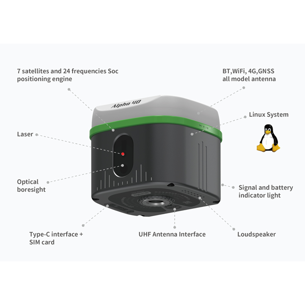
With 1408 GNSS channels, 60° IMU tilt compensation, laser measurement and dual AR stakeout, the Alpha 40 helps users measure faster around obstacles, hidden points, walls, road edges and busy construction areas where placing the pole perfectly upright is not always practical.
Alpha 40 Rover Set Highlights
| Receiver Type | Optic-electric RTK GNSS rover set |
|---|---|
| GNSS Channels | 1408 channels with GPS, BDS, GLONASS, Galileo, QZSS, SBAS and NavIC |
| RTK Accuracy | Horizontal ±(8 + 1×10⁻⁶D) mm, vertical ±(15 + 1×10⁻⁶D) mm |
| IMU Tilt Compensation | 0–60° tilt range with 200 Hz update rate |
| Laser Measurement | 50 m range with ±1 mm laser accuracy |
| Stakeout Guidance | Dual AR stakeout with visual field guidance |
| Connectivity | 4G, WiFi, Bluetooth 5.2, Type-C and built-in 2 W UHF radio |
| Field Software | DiMap Pro surveying software included |


Valued customers:


Find RTK Networks
Search NTRIP providers and connect to reliable RTK correction services.
Description
Alpha 40 Rover Set RTK GNSS Receiver with Laser IMU and AR Product Review
Alpha 40 Rover Set Product Review
The Alpha 40 Rover Set is a professional RTK GNSS rover package built for accurate field measurement, construction layout, engineering surveys, GIS data collection and drone mapping support. It combines the Alpha 40 optic-electric GNSS receiver with the Alpha Controller and DiMap Pro field software, giving field crews a complete rover workflow for measuring, staking out, managing CAD data and working with RTK correction services.
This rover set is designed for users who need more than a standard GNSS receiver. The Alpha 40 brings together satellite positioning, IMU tilt compensation, laser measurement, optical calibration and AR-assisted stakeout. In practice, this helps when points are difficult to reach, when a corner is hidden near a wall or fence, or when a construction team needs clear visual guidance during layout work.
Built for practical RTK fieldwork
Surveyors and site teams often work around buildings, road edges, kerbs, excavations, vegetation, machinery and other obstacles. In these situations, placing the pole directly and perfectly over every point is not always realistic. The Alpha 40 Rover Set helps reduce those limitations by combining RTK positioning with tilt compensation and laser-assisted measurement.
For topographic surveys, as-built checks, utility mapping, cadastral detail points and construction control, this means users can keep working efficiently without constantly repositioning the pole or forcing awkward measuring positions. It is especially useful for busy sites where speed, safety and repeatable accuracy all matter.
Laser measurement for hard-to-reach points
The Alpha 40 includes laser measurement with a 50 m range and ±1 mm laser accuracy. This gives field crews a practical way to measure points that are difficult, unsafe or inconvenient to reach directly with a survey pole.
Typical examples include building corners, drainage structures, points behind fences, road features, underpasses, slope edges, water edges and other locations where direct pole placement is difficult. By combining laser measurement with RTK positioning and inertial measurement, the Alpha 40 helps users capture these points more efficiently while staying in a workable position.
60° IMU tilt compensation
The Alpha 40 supports IMU tilt compensation from 0° to 60°. For day-to-day fieldwork, this means the operator does not always need to hold the pole perfectly vertical for every observation. This can save time during detail surveys, road measurements, construction checks, boundary work and utility surveys.
Tilt compensation is especially useful when working close to walls, parked vehicles, trenches, site barriers, traffic or dense vegetation. Instead of stopping to level the pole at every difficult point, the user can measure with a tilted pole while keeping the workflow moving.
Dual AR stakeout for easier layout
The Alpha 40 supports dual AR stakeout guidance, helping the user find target points with visual guidance in the real work environment. This is useful for construction layout, road stakeout, point stakeout and design checks where users need to understand not only the distance and direction to a point, but also where that point sits in relation to the site around them.
For less experienced GNSS users, AR guidance can make stakeout easier to understand than working only with numbers and arrows. For experienced surveyors, it can speed up point finding on busy or complex projects.
DiMap Pro field software included
The Alpha 40 Rover Set includes DiMap Pro, a professional field surveying application for GNSS workflows. It supports common site tasks such as point measurement, detail survey, control point measurement, point stakeout, CAD mapping, CAD stakeout, road design stakeout, earthwork measurement and elevation site control.
For construction and engineering work, CAD mapping and CAD stakeout are especially useful because design information can be taken into the field and used directly on the controller. This helps teams compare planned positions with actual site conditions and reduces the need to work from paper drawings alone.
DiMap Pro also includes practical calculation and field tools for area, volume, coordinate work and site measurement. This makes the Alpha 40 Rover Set suitable for surveyors, construction workers, GIS users, drone pilots and infrastructure teams who want one connected GNSS workflow in the field.
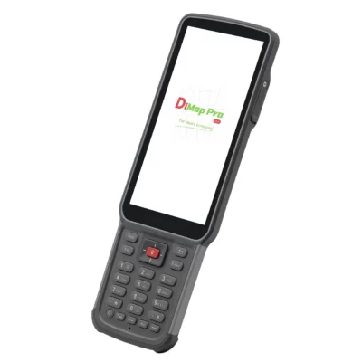
Alpha Controller for outdoor work
The included Alpha Controller is built for field use. It has a 5.5-inch screen, 8-core processor, 4 GB RAM, 64 GB storage, IP67 protection, 10-point touch support, rainy mode and glove mode. This makes it more suitable for surveying and construction environments than a standard consumer phone or tablet.
The controller runs DiMap Pro and connects the receiver, coordinate system settings, RTK correction workflow and field data in one system. For teams moving from a basic GNSS setup to a professional rover set, this helps keep the hardware and software workflow simple and practical.
Communication and correction options
The Alpha 40 supports several communication options for RTK work, including 4G, WiFi, Bluetooth 5.2, Type-C and a built-in UHF radio transceiver. The 2 W UHF radio supports the 410–470 MHz frequency range and common RTK radio protocols, giving users flexibility for both network RTK and radio-based base-rover workflows.
This makes the rover set suitable for projects using NTRIP correction services, a local base station or mixed communication setups depending on the jobsite. For international buyers and teams working across different project types, this flexibility helps keep the system adaptable.
Applications
The Alpha 40 Rover Set is suitable for a wide range of professional GNSS applications, including topographic surveying, construction layout, road stakeout, cadastral and boundary work, GIS data collection, utility mapping, drone ground control, earthwork measurement, volume calculation, photovoltaic layout, electric line survey and tower stakeout.
It is a strong option for users who want a complete rover package instead of buying a receiver, controller, software and accessories separately. The combination of RTK GNSS, laser measurement, IMU tilt and AR stakeout makes it useful for both standard surveying tasks and more complex field situations.
What is included in the Alpha 40 Rover Set?
- Alpha 40 GNSS receiver
- Radio antenna
- Host adapter and host cable
- Alpha Controller
- Controller adapter and controller cable
- Centering pole
- Bracket
- Instruction documentation
- Carrying case
Why buy from Global GPS Systems?
When you buy the Alpha 40 Rover Set from Global GPS Systems, you are buying from a specialist supplier that works with GNSS receivers, RTK correction workflows, field software and survey equipment every day. Our team can help you compare rover setups, understand correction options and choose the right configuration for your type of work.
Global GPS Systems supports customers worldwide with insured shipping from the Netherlands, warranty handling and practical product advice. For surveyors, construction companies, GIS teams and drone mapping professionals, that support can be just as important as the hardware itself.
Datasheets & Manuals
Datasheets and manuals
Datasheets
Specifications
Alpha 40 Rover Set Specifications
Product Overview
| Product Name | Alpha 40 Rover Set |
|---|---|
| Receiver Type | Optic-electric RTK GNSS rover |
| System Type | Complete RTK GNSS rover set |
| Primary Applications | Surveying, construction layout, engineering, GIS data collection, drone mapping, CAD mapping, road work, earthwork measurement and stakeout |
| Included Field Software | DiMap Pro |
| Key Functions | RTK positioning, static measurement, IMU tilt measurement, laser measurement, optical calibration, dual AR stakeout, CAD mapping and GNSS data collection |
| Available Version Types | Laser with one-camera; laser with dual-camera |
GNSS Performance
| GNSS Channels | 1408 |
|---|---|
| GPS Signals | L1C/A, L1C, L2C, L2P, L5 |
| BDS Signals | B1I, B2I, B3I, B1C, B2a, B2b |
| GLONASS Signals | G1, G2, G3 |
| Galileo Signals | E1, E5a, E5b, E6 |
| QZSS Signals | L1C/A, L1C, L2C, L5 |
| SBAS Signal | L1 |
| NavIC Signal | L5 |
| Static Accuracy – Horizontal | ±(2.5 + 0.5 × 10⁻⁶D) mm |
| Static Accuracy – Vertical | ±(5 + 0.5 × 10⁻⁶D) mm |
| RTK Accuracy – Horizontal | ±(8 + 1 × 10⁻⁶D) mm |
| RTK Accuracy – Vertical | ±(15 + 1 × 10⁻⁶D) mm |
| Update Rate | 200 Hz |
Tilt Compensation and Inertial Navigation
| Tilt Compensation Range | 0° to 60° |
|---|---|
| Tilt Compensation Accuracy | ±(8 + 0.3 × TILT) mm |
| Inertial Navigation Accuracy | 0.015° |
| IMU Type | Military-grade professional IMU / inertial navigation module |
| Tilt Initialization | No formal initialization required; enter inertial navigation mode after walking a few steps |
| High-Inclination Measurement | Supports measurement at extreme inclination angles using fused IMU, positioning and magnetometer data |
| Temperature Compensation | Supported |
Laser Measurement and Optical System
| Laser Measurement Range | 50 m |
|---|---|
| Laser Accuracy | ±1 mm |
| Non-Contact Measurement | 360° non-contact measurement supported |
| Non-Contact Measurement Accuracy | 3–5 cm at 10 m distance |
| Optical Calibration | Synchronizes the crosshair aiming point with the actual laser measurement target |
| Laser Measurement Use Cases | Hidden cadastral points, aerial points, underground points and inaccessible points |
| Laser / RTK Fusion | Laser ranging, RTK positioning, IMU and optical calibration data are algorithmically fused for indirect point measurement |
AR Stakeout and Camera Functions
| AR Stakeout | Dual AR-guided stakeout |
|---|---|
| Remote AR Stakeout | Supported |
| Proximal AR Stakeout | Supported |
| AR View Switching | Switches to near-view AR at approximately 5 m; distance is adjustable |
| AR Display | 360° real-time real-scene display designed for outdoor visibility |
| Real-Scene Point Finding Accuracy | 1 cm |
| Lens System | Image-level lens with small optical distortion and professional correction algorithms |
System Parameters
| Operating System | Linux |
|---|---|
| Internal Memory | 32 GB |
| Data Recording Formats | DAT, RINEX |
| Voice Support | Intelligent voice supported |
| Satellite / Datalink Indicators | Satellite, datalink, Bluetooth and battery indicator lights |
| WebUI | Supported |
| PPP | Supported |
Communications and Connectivity
| Mobile Network | 4G |
|---|---|
| Wi-Fi | 802.11a/b/g/n/ac |
| Bluetooth | Bluetooth 5.2 BR/EDR + LE dual-mode Bluetooth |
| Type-C Port | Charging, data transmission and external port connection |
| SMA Port | Radio UHF antenna connection |
| 4G Card Slot | Supported |
| External Port Support | Supports external connection workflows through Type-C and serial/port customization functions |
UHF Radio
| Radio Type | Built-in dual-mode radio transceiver with UHF and LoRa support |
|---|---|
| Radio Power | 2 W |
| Frequency Range | 410–470 MHz |
| Operation Mode | Transceiver |
| Supported Protocols | TRIMTALK 450S, TRIMMARK III, SOUTH9600, SOUTH19200, SATEL9600, SATEL19200, TRANSPARENT, LoRa |
| Typical Radio Range | Up to 5 km in suitable open conditions with the base station placed in a high, open area |
| External Radio Support | Serial port enables connectivity with external high-power radios |
Power
| Power Input | 9–20 V Power Delivery |
|---|---|
| Battery Capacity | 37 Wh |
| Working Time – NTRIP | Up to 18 hours |
| Working Time – Radio Receiving | Up to 15 hours |
| Working Time – Radio Transmitting | Up to 8 hours |
| Charging Interface | Type-C |
Alpha Controller
| Display | 5.5-inch large screen |
|---|---|
| Processor | 8-core |
| Memory / Storage | 4 GB RAM + 64 GB storage |
| Protection Rating | IP67 |
| Touch Input | 10-point touch |
| Rain Mode | Supported |
| Glove Mode | Supported |
DiMap Pro Field Software
| Point Measurement | Supported |
|---|---|
| Detail Measurement | Supported |
| Control Point Measurement | Supported |
| Point Stakeout | Supported |
| CAD Mapping | Supported |
| Road Design Stakeout | Supported |
| Power Survey | Supported |
| Elevation Site Control | Supported |
| Line Measurement | Supported |
| Surface Measurement | Supported |
| Curve Stakeout | Supported |
| Tower Base Stakeout | Supported |
| Photovoltaic Stakeout | Supported |
| Earthwork Measurement | Supported |
| Large CAD File Support | Smooth opening and running of files over 100 MB |
| Map Support | Amap standard map, Amap satellite map, OpenStreetMap and WMS map configuration |
| Map Calibration | Supported |
| Cloud / File Sharing | Supported |
| Shortcut Key Customization | Supported |
| Post-Measurement Correction | Supported |
| Built-In Calculator | Supported |
Drone and External System Support
| Drone Base Station Function | Supported |
|---|---|
| Serial Port Customization | Supported |
| Unmanned System Integration | Supports positioning fusion for unmanned systems and laser radar workflows |
| Intelligent Terminal Collaboration | Designed to work with smart terminals, optoelectronic products and unmanned systems |
Physical Specifications
| Receiver Dimensions | 100 mm × 100 mm × 80 mm, excluding 5/8-inch pin interface |
|---|---|
| Receiver Weight | 650 g |
| Housing | Aluminum-magnesium alloy housing with shielding middle frame |
| Antenna Cover | Nano wave-transparent cover |
| Pole | 1.8 m lightweight carbon fiber portable pole |
| Pole Retracted Length | 75 cm |
| Mounting Interface | 5/8-inch pin interface |
Environmental Specifications
| Operating Temperature | -30°C to +70°C |
|---|---|
| Storage Temperature | -40°C to +80°C |
| Water / Dust Protection | IP67 |
| Shock Resistance | Normal temperature resistance of 1.8 m drop onto hard ground |
| Humidity | Up to 100% |
Package Contents
| Item | Quantity | Notes |
|---|---|---|
| Alpha 40 GNSS Receiver | 1 | Optic-electric RTK GNSS receiver |
| Radio Antenna | 1 | For UHF radio operation |
| Host Adapter | 1 | Receiver power/accessory adapter |
| Host Cable | 1 | Receiver cable |
| Controller | 1 | Alpha Controller |
| Controller Adapter | 1 | Controller charging/accessory adapter |
| Controller Cable | 1 | Controller cable |
| Centering Pole | 1 | 1.8 m lightweight carbon fiber portable pole |
| Bracket | 1 | Controller/field bracket |
| Instruction | 1 | Product documentation |
| Carrying Case | 1 | Transport and storage case |
Specifications and package contents may vary by configuration, region or manufacturer update. Always check the current configuration before ordering.
FAQ
Alpha 40 Rover Set FAQ
Product Overview
What is the Alpha 40 Rover Set?
The Alpha 40 Rover Set is a complete RTK GNSS rover package for high-accuracy field positioning. It combines the Alpha 40 optic-electric GNSS receiver, Alpha Controller and DiMap Pro field software for surveying, stakeout, CAD mapping, construction layout, GIS data collection and engineering workflows.
Who is the Alpha 40 Rover Set designed for?
The Alpha 40 Rover Set is designed for professional surveyors, construction teams, civil engineers, GIS users, drone mapping professionals, utility mapping teams, cadastral surveyors and infrastructure crews that need centimetre-level positioning in the field.
What is included in the Alpha 40 Rover Set?
The set includes the Alpha 40 receiver, radio antenna, host adapter, host cable, controller, controller adapter, controller cable, centering pole, bracket, instruction documentation and carrying case.
What is the difference between the Alpha 40 Rover Set and the receiver only?
The receiver-only option includes the Alpha 40 GNSS receiver, while the Rover Set is a more complete field package with the receiver, controller, DiMap Pro software, pole, bracket, cables, radio antenna and carrying case.
What is the difference between a Rover Set and a Rover & Base Set?
A Rover Set is intended for use as a mobile GNSS rover, often with NTRIP or an existing correction source. A Rover & Base Set includes equipment for both rover and base workflows, which is useful when you need to create your own local RTK correction setup.
Which industries use the Alpha 40 Rover Set?
The Alpha 40 Rover Set is used in land surveying, construction, civil engineering, road work, cadastral mapping, GIS data collection, utility mapping, drone mapping, earthworks, photovoltaic layout and infrastructure projects.
Accuracy, GNSS and RTK Corrections
Does the Alpha 40 support RTK positioning?
Yes. The Alpha 40 supports RTK positioning with a specified horizontal RTK accuracy of ±(8 + 1×10⁻⁶D) mm and vertical RTK accuracy of ±(15 + 1×10⁻⁶D) mm.
How many GNSS channels does the Alpha 40 have?
The Alpha 40 has 1408 GNSS channels, allowing it to track multiple satellite constellations and frequencies for professional positioning workflows.
Which satellite systems does the Alpha 40 track?
The Alpha 40 tracks GPS, BeiDou, GLONASS, Galileo, QZSS, SBAS and NavIC signals. This multi-constellation support helps improve positioning availability in different field environments.
Can the Alpha 40 be used with NTRIP corrections?
Yes. The Alpha 40 includes onboard 4G connectivity, making it suitable for NTRIP correction workflows where mobile network coverage and a compatible RTK correction service are available.
Does the Alpha 40 have a built-in UHF radio?
Yes. The Alpha 40 includes a built-in 2 W UHF radio transceiver covering 410–470 MHz. It supports multiple protocols, including TRIMTALK 450S, TRIMMARK III, SOUTH9600, SOUTH19200, SATEL9600, SATEL19200, TRANSPARENT and LoRa.
Can the Alpha 40 work without mobile network coverage?
Yes, the built-in UHF radio can support radio-based RTK workflows when a compatible base station and radio setup are available. This is useful on sites where mobile coverage for NTRIP is limited or unavailable.
Laser, IMU and AR Stakeout
What is the laser measurement function used for?
The laser measurement function helps measure points that are difficult, unsafe or inconvenient to reach directly with the survey pole. It is useful near walls, fences, ditches, obstacles, traffic, excavations, drainage structures and hidden corners.
What is the laser measurement range of the Alpha 40?
The Alpha 40 has a specified laser measurement range of 50 m and a specified laser accuracy of ±1 mm.
Can the Alpha 40 measure inaccessible points?
Yes. The Alpha 40 combines GNSS positioning, laser measurement, optical calibration and IMU tilt compensation to support non-contact measurement of hard-to-reach or inaccessible points.
Does the Alpha 40 support IMU tilt compensation?
Yes. The Alpha 40 supports IMU tilt compensation from 0° to 60°, helping users measure points faster when the pole cannot be held perfectly vertical.
How accurate is the tilt compensation?
The specified tilt compensation accuracy is ±(8 + 0.3 × tilt) mm, with a 200 Hz update rate. This supports efficient field measurement around obstacles, uneven terrain and busy construction sites.
What is dual AR stakeout?
Dual AR stakeout uses real-world visual guidance to help operators find and stake out target points more intuitively. It can make construction layout and point finding easier because the target position is shown in relation to the real surroundings.
Software, Field Use and Durability
Which software is included with the Alpha 40 Rover Set?
The Alpha 40 Rover Set includes DiMap Pro field surveying software. DiMap Pro supports project setup, coordinate systems, localization, point management, import and export, field measurement, stakeout and calculation tools.
What survey functions does DiMap Pro support?
DiMap Pro supports point survey, detail survey, control point survey, point stakeout, CAD mapping, CAD stakeout, line stakeout, road stakeout, DSM stakeout, electric line survey, electric tower stakeout and practical calculation tools.
Can the Alpha 40 Rover Set be used for CAD mapping and CAD stakeout?
Yes. DiMap Pro supports CAD mapping and CAD stakeout, including layer-based workflows and field drawing functions. This helps users bring design data into the field for layout and verification tasks.
Is the Alpha Controller suitable for outdoor work?
Yes. The Alpha Controller has a 5.5-inch screen, 8-core processor, 4 GB RAM, 64 GB storage, IP67 protection, 10-point touch support, rainy mode and glove mode for demanding field environments.
Is the Alpha 40 waterproof and dustproof?
Yes. The Alpha 40 receiver has an IP67 water and dust protection rating, making it suitable for professional outdoor use in challenging field conditions.
What battery life does the Alpha 40 offer?
The Alpha 40 has a 37 Wh battery. The specified working time is up to 18 hours with NTRIP, 15 hours with radio receiving and 8 hours with radio transmitting.
Can the Alpha 40 Rover Set be used for drone mapping support?
Yes. The Alpha 40 Rover Set can be used for drone mapping support, including ground control point measurement and high-accuracy field positioning workflows for UAV mapping projects.
Additional information
| GNSS feature | GNSS with Camera, GNSS with IMU, GNSS with Laser |
|---|
Reviews (0)
Only logged in customers who have purchased this product may leave a review.


Reviews
There are no reviews yet