

 GPS & GNSS
 Lidar
 RTK Data & NTRIP
 Total Station
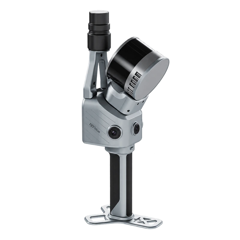
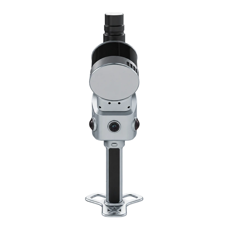
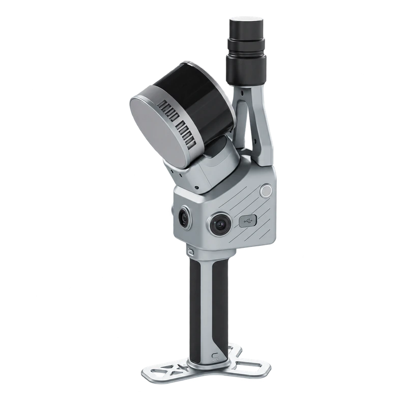
FJD Trion T1 Hybrid SLAM and Terrestrial 3D LiDAR Scanner
Get the best price for your setup
Contact our experts for the best possible price and configuration.
- Fast response
- Expert configuration advice
- No overpaying for features you do not need
The FJD Trion T1 is a hybrid 3D LiDAR scanner that combines fast mobile SLAM scanning with accurate tripod-based terrestrial scanning. Designed for surveying, construction, infrastructure inspection and as-built documentation, it allows professionals to capture large areas while walking and switch to stationary scanning when greater local measurement detail is required.
With a mobile scanning range of up to 120 m, 640,000 points per second and integrated RTK GNSS, the Trion T1 delivers detailed 3D point clouds for both indoor and outdoor projects. Mobile Mode provides relative accuracy of ≤1 cm, while Terrestrial Mode achieves 4 mm at 10 m under specified conditions. Three 48 MP imaging cameras support colourised point clouds, while real-time scanning previews help operators check coverage directly in the field.
FJD Trion T1 Highlights
| Scanning technology | Hybrid mobile SLAM and tripod-based terrestrial LiDAR |
|---|---|
| Mobile scanning range | 0.5–120 m |
| Terrestrial scanning range | 0.5–60 m |
| Relative accuracy | Mobile: ≤1 cm; terrestrial: 4 mm at 10 m and 8 mm at 30 m |
| Scanning speed | 640,000 points per second |
| Field of view | 360° horizontal × 270° vertical |
| Cameras | 3 × 48 MP imaging cameras and 1080p RGB vision camera |
| GNSS positioning | Integrated multi-constellation RTK GNSS with PPK support |
| Battery life | Up to 3.5 hours with dual handles |
| Weight and protection | 1.65 kg main unit; 2.23 kg complete setup; IP54 |
You may also like…
Lidar & 3D scanning
FJD Trion X1 Handheld SLAM LiDAR Scanner with GNSS and 360 Camera
Lidar & 3D scanning
Valued customers:










Find RTK Networks
Search NTRIP providers and connect to reliable RTK correction services.
Description
FJD Trion T1 Hybrid SLAM and Terrestrial 3D LiDAR Scanner
The FJD Trion T1 is a professional hybrid 3D LiDAR scanner designed for land surveying, construction, building documentation and infrastructure mapping. Combining mobile SLAM technology with precise terrestrial laser scanning, it allows users to capture large areas efficiently and collect more detailed measurements of critical locations using the same instrument.
In Mobile Mode, the Trion T1 can be carried through buildings, construction sites and outdoor environments while continuously collecting 3D measurements. For tasks requiring greater local accuracy, the scanner can be mounted on a tripod and switched to Terrestrial Mode. This makes it particularly useful for projects involving both large-scale site documentation and detailed measurements of structures, equipment or architectural features.
With up to 640,000 measurements per second, a 120 m maximum mobile scanning range, integrated RTK GNSS and high-resolution imaging cameras, the Trion T1 provides a flexible scanning workflow for surveyors, engineers and 3D mapping professionals.
Mobile SLAM and Terrestrial Scanning in One System
One of the main advantages of the FJD Trion T1 is the ability to switch between two scanning methods depending on the requirements of the project. Instead of using separate instruments for fast mobile data collection and detailed stationary scanning, operators can work with one system throughout the surveying process.
Mobile SLAM Scanning for Fast Site Coverage
In Mobile Mode, the Trion T1 uses simultaneous localisation and mapping (SLAM) technology to estimate the scanner’s movement while capturing the surrounding environment. Operators can walk through rooms, corridors, industrial buildings and outdoor areas while the system continuously generates 3D measurements.
The mobile scanning range extends from 0.5 to 120 metres, with specified relative accuracy of ≤1 cm under reference conditions. This makes mobile scanning useful for documenting large buildings, warehouses, construction sites and other environments where setting up a tripod at every position would take additional time.
The system supports continuous scanning sessions of up to one hour. Larger sites can be captured in multiple sessions by revisiting previously scanned areas, allowing compatible datasets to be aligned and combined during processing.
Terrestrial Scanning for Detailed Measurements
When higher local accuracy is required, the Trion T1 can be mounted on a tripod and operated in Terrestrial Mode. This stationary scanning method provides specified relative accuracy of 4 mm at 10 metres and 8 mm at 30 metres, with a measurement range of 0.5 to 60 metres.
For surveyors and engineers, this is useful when documenting structural details, building façades, machinery, industrial installations and other objects where accurate local geometry is important. Operators can scan the wider environment in Mobile Mode and then capture selected areas at a higher level of detail.
Terrestrial scanning times range from approximately 30 seconds to 2 minutes per station, depending on the selected point density. This allows users to balance measurement detail and fieldwork efficiency according to the project requirements.
640000 Points per Second for Detailed 3D Mapping
The FJD Trion T1 uses a 905 nm Class 1 laser scanner capable of collecting up to 640,000 points per second. Its wide 360° horizontal and 270° vertical field of view provides extensive coverage of the surrounding environment, including walls, floors, ceilings, structures and visible terrain.
The maximum LiDAR measurement distance is 120 metres on targets with 80% reflectivity and 80 metres on targets with 10% reflectivity. In practice, this means brighter surfaces can often be measured at greater distances than darker or less reflective materials.
The high measurement rate helps produce detailed point clouds that can be used to document existing conditions, analyse structural geometry and prepare spatial information for engineering projects. Actual scan completeness depends on measurement distance, surface characteristics, scanner movement and line of sight.
Integrated RTK GNSS for Georeferenced Point Clouds
The Trion T1 includes an integrated multi-constellation GNSS receiver supporting GPS, GLONASS, Galileo, BeiDou and QZSS. Its RTK functionality enables compatible outdoor scanning workflows to connect collected data to a geographical coordinate system using correction information.
The GNSS subsystem provides specified RTK positioning accuracy of 8 mm + 1 ppm horizontally and 15 mm + 1 ppm vertically under reference conditions. Post-processed kinematic (PPK) positioning is also supported, providing an additional option for projects where real-time corrections are unavailable or post-processing is preferred.
For land surveyors and GIS professionals, georeferenced point clouds are useful when combining scanned environments with existing survey control, mapping data and engineering drawings.
It is important to distinguish GNSS positioning accuracy from complete point cloud accuracy. The final accuracy of a scanning project depends on satellite reception, SLAM performance, processing, survey control and operating conditions. Indoor projects or environments with limited satellite visibility may require additional control measurements.
High Resolution Cameras for Colourised 3D Point Clouds
The FJD Trion T1 features three 48 MP imaging cameras together with a separate 1080p RGB vision camera. These cameras provide visual information that can be combined with LiDAR measurements to create detailed, colourised 3D point clouds.
During mobile scanning, the system uses two 48 MP imaging cameras and the RGB vision camera. In Terrestrial Mode, all three 48 MP cameras are available for panoramic imaging.
Colourised point clouds make it easier to recognise building materials, equipment, roads, vegetation and other objects within the scanned environment. This is particularly useful for architects, engineers and construction managers who need to interpret complex point cloud data without relying only on geometric shapes or laser intensity values.
The imaging system also supports detailed panoramic documentation, helping users review the physical appearance of a site alongside its three-dimensional measurements.
Real Time Scanning Preview and Field Verification
During data collection, the FJD Trion scanning workflow supports real-time point cloud previews in 2D and 3D. Operators can review the captured environment while scanning, making it easier to identify missing areas and check whether important features have been recorded.
This is valuable when surveying complex buildings, industrial facilities and construction sites where obstacles may block the scanner’s line of sight. Instead of discovering incomplete coverage during office processing, operators can inspect the scan in the field and collect additional measurements where necessary.
For larger projects, the Trion T1 also supports continuing scans from previously captured areas, allowing survey teams to divide a site into manageable sections.
Flexible Scanning for Handheld Vehicle and Airborne Applications
The Trion T1 is designed to support different scanning configurations. Its primary operating methods are handheld mobile scanning and tripod-based terrestrial scanning, while compatible vehicle-mounted and airborne configurations extend the system’s potential applications.
The main scanning unit weighs approximately 1.65 kg, while a complete configuration with battery, base and RTK components weighs approximately 2.23 kg. This makes the system practical for portable scanning work, including building interiors, construction sites and infrastructure environments.
For vehicle-mounted projects, mobile LiDAR can help capture roads, infrastructure corridors and large outdoor areas. Airborne integration may also be possible with suitable mounting hardware and a compatible platform. Operators should verify the required accessories, mounting configuration and operating limitations before use.
The scanner provides up to 3.5 hours of battery operation with dual handles. It includes 512 GB of internal storage, expandable to 1 TB, and supports data transfer through Wi-Fi and USB Type-C. An IP54 protection rating provides resistance to dust and splashing water during normal fieldwork.
Applications in Surveying Construction and Engineering
Building Surveys and As Built Documentation
The FJD Trion T1 is suitable for documenting existing buildings before renovation, extension or refurbishment work. Surveyors can use Mobile Mode to capture complete floor layouts, rooms and corridors, then perform detailed terrestrial scans around structural elements and other important features.
The resulting point clouds can support floor plans, elevations, cross-sections and three-dimensional building models when processed using suitable software.
Construction and Civil Engineering
Construction professionals can use the Trion T1 to record existing site conditions, check structural geometry and create digital representations of construction areas. Point clouds can support site planning, engineering coordination and comparisons between different project stages.
Combining mobile and stationary scanning is particularly useful when a site requires both broad coverage and detailed measurements of selected construction elements.
Industrial Facilities and Plant Engineering
Industrial engineers can use the Trion T1 to document machinery, pipework, steel structures and other equipment within factories or production facilities. Mobile scanning provides an efficient overview of larger spaces, while Terrestrial Mode supports more detailed measurements of critical installations.
The resulting data can assist with plant modifications, equipment replacement, spatial coordination and the preparation of accurate existing-condition models.
Road Bridges and Infrastructure Mapping
The scanner can collect 3D information about roads, bridges, tunnels, retaining walls and surrounding infrastructure. Its hybrid approach is useful for projects requiring rapid coverage of long or complex areas together with detailed measurements at selected locations.
Vehicle-mounted scanning configurations can also support infrastructure corridor mapping when suitable mounting and operating arrangements are used.
Mining and Quarrying
Surveyors working in mines and quarries can use the Trion T1 to capture accessible excavation areas, underground spaces and exposed surfaces. Processed point clouds can support cross-section analysis, geometric documentation and volume calculations when suitable survey control and processing methods are applied.
Forestry and Environmental Surveys
The Trion T1 can capture the visible geometry of trees, vegetation and surrounding terrain. Forestry specialists can use point cloud processing tools to analyse tree structure, vegetation dimensions and spatial relationships within surveyed areas.
The level of detail depends on scanning distance, vegetation density and available lines of sight. Additional scan positions may be needed to capture complex tree structures or areas with dense vegetation.
Point Cloud Processing with FJD Trion Model
After scanning, the FJD Trion T1 works with FJD Trion Model for professional point cloud processing and analysis. The software supports working with mobile and terrestrial datasets, allowing users to process them independently or combine them into a single 3D representation.
Available processing workflows include point cloud handling, mesh generation, cross-section analysis, CAD and BIM-related work, 3D Gaussian Splatting and specialised forestry analysis. These functions help transform collected scan data into practical deliverables for surveying, engineering, construction and digital documentation.
FJD Trion Model Web also provides browser-based project access, review and sharing, making it easier for teams and clients to work with captured site information across different locations.
Software capabilities, export options and licensing depend on the selected software edition and system configuration. Users should confirm the required functionality for their intended project deliverables.
FJD Trion T1 at Global GPS Systems
The FJD Trion T1 is designed for professional surveyors, construction companies, engineers, architects and 3D mapping specialists who need efficient site coverage without giving up the option of detailed stationary measurements.
Its combination of mobile SLAM scanning, terrestrial LiDAR, integrated RTK GNSS and high-resolution camera imaging makes it a versatile solution for documenting buildings, infrastructure, industrial facilities and outdoor environments.
At Global GPS Systems, we help customers select professional LiDAR and GNSS equipment suited to their projects. Contact our team for guidance on the FJD Trion T1, compatible accessories, RTK configurations and point cloud processing software for your surveying workflow.
Specifications
FJDynamics FJD Trion T1 Hybrid Mobile & Terrestrial LiDAR Scanner Specifications
General Specifications
| Manufacturer | FJDynamics |
|---|---|
| Product Name | FJD Trion T1 |
| Model | T1 |
| Product Type | Hybrid mobile and terrestrial 3D LiDAR scanner |
| Scanning Technology | 3D LiDAR with multi-sensor simultaneous localisation and mapping (SLAM) |
| Scanning Modes | Mobile scanning and fixed-position terrestrial scanning |
| Supported Operating Configurations | Handheld, tripod-mounted, vehicle-mounted and airborne scanning with compatible accessories |
| Maximum LiDAR Measurement Range | 120 m at 80% target reflectivity |
| Maximum Point Acquisition Rate | 640,000 points/second |
| LiDAR Field of View | 360° horizontal × 270° vertical |
| Mobile Scanning Relative Accuracy | ≤ 1 cm |
| Terrestrial Scanning Relative Accuracy | 4 mm at 10 m; 8 mm at 30 m |
| Laser Wavelength | 905 nm |
| Laser Safety Classification | Class 1 |
| Integrated RGB Imaging Cameras | 3 × 48 MP |
| Integrated Vision Camera | 1 × 1080p RGB camera |
| GNSS Positioning | Multi-constellation GNSS with RTK and PPK support |
| Internal Storage | 512 GB, expandable to 1 TB |
| Operating Temperature | -20°C to +50°C |
| Ingress Protection | IP54 |
| Main Unit Weight | 1.65 kg |
| Complete Setup Weight | 2.23 kg including battery, base and RTK components |
| Dimensions | 108 × 173 × 433 mm |
| Power Consumption | 24 W |
| Primary Applications | Surveying and mapping, construction, architecture, infrastructure engineering, industrial facilities, forestry, mining, quarrying and 3D reality capture |
Mobile and Terrestrial Scanning Comparison
| Specification | Mobile Scanning | Terrestrial Scanning |
|---|---|---|
| Scanning Method | Continuous mobile 3D scanning | Fixed-position 3D laser scanning |
| Positioning Method | Multi-sensor SLAM with supported GNSS/RTK positioning workflows | Fixed-station scanning with SLAM-assisted station registration |
| Measurement Range | 0.5–120 m | 0.5–60 m |
| Relative Accuracy | ≤ 1 cm | 4 mm at 10 m; 8 mm at 30 m |
| Maximum Point Rate | 640,000 points/second | 640,000 points/second |
| LiDAR Field of View | 360° × 270° | 360° × 270° |
| Active Cameras | 1 × 1080p vision camera and 2 × 48 MP imaging cameras | 3 × 48 MP imaging cameras |
| Scanning Duration | Up to 1 hour per continuous scanning session | Approximately 30 seconds to 2 minutes per station |
| Point Cloud Density | Continuous acquisition during movement | Selectable scanning density through station scanning duration |
| Point Cloud Colourisation | Supported | Supported |
| Real-Time Point Cloud Preview | 2D and 3D colourised point cloud preview | Supported through compatible scanning and processing software |
| Scan Registration | SLAM-based mobile scan alignment | Multi-sensor SLAM-assisted alignment between scanning stations |
| Multi-Session Data Combination | Supported through previously scanned area matching | Supported through compatible registration workflows |
| Typical Applications | Large sites, road corridors, forestry, infrastructure and general spatial mapping | Detailed building surveys, industrial equipment, critical infrastructure and precision measurement areas |
LiDAR Scanner Specifications
| Scanner Type | 3D laser scanner |
|---|---|
| Laser Wavelength | 905 nm |
| Laser Safety Class | Class 1 |
| Maximum Measurement Rate | 640,000 points/second |
| Maximum Detection Range at 80% Reflectivity | 120 m |
| Maximum Detection Range at 10% Reflectivity | 80 m |
| Mobile Scanning Range | 0.5–120 m |
| Terrestrial Scanning Range | 0.5–60 m |
| Minimum Measurement Distance | 0.5 m |
| Horizontal Field of View | 360° |
| Vertical Field of View | 270° |
| Combined Field of View | 360° × 270° |
| Point Cloud Type | 3D spatial point cloud |
| Real-Time Point Cloud Visualisation | Supported |
| RGB Point Cloud Colourisation | Supported using integrated imaging cameras |
| LiDAR Range Conditions | Maximum detection range depends on target reflectivity and environmental conditions |
| Laser Angular Resolution | Not specified in the published manufacturer brochure |
| Multiple Return Capability | Not specified in the published manufacturer brochure |
| Standalone Laser Ranging Accuracy | Not specified separately from the scanning mode relative accuracy |
Measurement Accuracy and Precision
| Mobile Mode Relative Accuracy | ≤ 10 mm |
|---|---|
| Terrestrial Mode Relative Accuracy at 10 m | 4 mm |
| Terrestrial Mode Relative Accuracy at 30 m | 8 mm |
| Accuracy Type | Relative scanning accuracy |
| Terrestrial Accuracy Across Density Settings | Same manufacturer-rated relative accuracy for the available scanning density settings |
| Terrestrial Measurement Method | Stationary laser scanning for detailed local measurements |
| Mobile Measurement Method | Continuous scanning with multi-sensor SLAM |
| Multi-Station Registration | SLAM-assisted registration of successive scanner positions |
| Absolute Point Cloud Accuracy | Not specified as a single system-wide value in the manufacturer brochure |
| Accuracy Qualification | Relative scanning accuracy is not equivalent to absolute georeferencing accuracy. Project accuracy depends on scanning geometry, environmental conditions, positioning quality, control data and processing. |
RGB Imaging Camera Specifications
| Camera Type | Integrated RGB imaging cameras |
|---|---|
| Number of Imaging Cameras | 3 |
| Resolution per Camera | 48 megapixels |
| Imaging Unit Field of View | 360° × 235° |
| Lens Aperture | f/2 |
| Active Imaging Cameras in Mobile Mode | 2 × 48 MP |
| Active Imaging Cameras in Terrestrial Mode | 3 × 48 MP |
| Panoramic RGB Imaging | Supported |
| 360° Panoramic Capture | Supported |
| True-Colour Point Cloud Generation | Supported |
| Camera Application | Colour attribution, panoramic visual documentation and 3D scene capture |
RGB Vision Camera Specifications
| Camera Type | RGB vision camera |
|---|---|
| Number of Vision Cameras | 1 |
| Resolution | 1080p |
| Horizontal Field of View | 80° |
| Vertical Field of View | 47° |
| Combined Field of View | 80° × 47° |
| Lens Aperture | f/2.2 |
| Mobile Scanning Operation | Active |
| Terrestrial Scanning Operation | Not listed among the active cameras in terrestrial mode |
| Vision Sensor Integration | Integrated into the multi-sensor mobile scanning system |
GNSS and RTK Positioning
| Positioning Technology | Multi-constellation GNSS with RTK capability |
|---|---|
| Supported Satellite Constellations | BeiDou, GPS, GLONASS, Galileo and QZSS |
| BeiDou (BDS) | Supported |
| GPS | Supported |
| GLONASS | Supported |
| Galileo | Supported |
| QZSS | Supported |
| RTK Horizontal Accuracy | 8 mm + 1 ppm RMS |
| RTK Vertical Accuracy | 15 mm + 1 ppm RMS |
| Positioning Accuracy Reference | RMS (Root Mean Square) |
| PPK Mode | Supported |
| GNSS-Based Georeferencing | Supported through compatible scanning and processing workflows |
| GNSS Tracking Channels | Not specified in the published manufacturer brochure |
| GNSS Signal Frequencies | Not specified in the published manufacturer brochure |
| RTK Accuracy Qualification | Published RTK values describe GNSS positioning performance and do not guarantee equivalent absolute accuracy for every scanned point |
SLAM and Mapping Functions
| SLAM Technology | Multi-sensor simultaneous localisation and mapping |
|---|---|
| Continuous Mobile Mapping | Supported |
| Terrestrial Station Registration | SLAM-assisted |
| Real-Time Point Cloud Preview | Supported |
| 2D Point Cloud Visualisation | Supported |
| 3D Point Cloud Visualisation | Supported |
| Real-Time Colourised Preview | Supported |
| Scan Coverage Review | Visual identification of potential coverage gaps during acquisition |
| Multi-Session Scanning | Supported |
| Previously Scanned Area Matching | Supported |
| Automatic Session Combination | Supported through matching previously scanned areas |
| Mobile and Terrestrial Data Fusion | Supported |
| Separate Processing by Scanning Mode | Supported |
| Multi-Station Spatial Relationships | Recorded through multi-sensor SLAM to assist scan alignment during post-processing |
| Continuous Mobile Session Duration | Up to 1 hour |
Scanning Speed and Operational Performance
| Maximum Point Acquisition Rate | 640,000 points/second |
|---|---|
| Maximum Mobile Scanning Session | 1 hour |
| Fastest Terrestrial Scan | 30 seconds per station |
| Higher-Density Terrestrial Scan | Up to 2 minutes per station |
| Selectable Terrestrial Scan Density | Supported |
| Terrestrial Accuracy Across Density Settings | Same manufacturer-rated accuracy |
| Multi-Session Survey Continuation | Supported through existing scan area matching |
| Mobile Scanning Operation | Continuous scanning while moving |
| Terrestrial Scanning Operation | Stationary scanning from a compatible tripod or fixed mount |
| Hybrid Scanning Workflow | Mobile capture for overall coverage combined with terrestrial capture for higher-accuracy local measurements |
Battery and Power Specifications
| Power Supply | Handle battery and external DC power |
|---|---|
| Battery Capacity | 43.2 Wh |
| Published Battery Operating Time | 3.5 hours with dual handles |
| Power Consumption | 24 W |
| External DC Power | Supported |
| Dual-Handle Battery Configuration | Supported |
| Battery Chemistry | Not specified in the published manufacturer brochure |
| External DC Input Voltage | Not specified in the published manufacturer brochure |
| Battery Charging Time | Not specified in the published manufacturer brochure |
| Battery Endurance Qualification | Published 3.5-hour endurance is based on a dual-handle configuration; actual operating time depends on battery condition and operating conditions |
Data Storage and Connectivity
| Internal Storage | 512 GB |
|---|---|
| Maximum Published Storage Capacity | 1 TB |
| Storage Expansion | Supported |
| Wireless Data Transfer | Wi-Fi |
| Wired Data Connection | USB Type-C |
| Data Export Interfaces | Wi-Fi and USB Type-C |
| 3D Point Cloud Data | Supported |
| RGB Image Data | Supported |
| Positioning Data | GNSS/RTK and applicable positioning information |
| Mobile Scan Data | Supported |
| Terrestrial Scan Data | Supported |
| Cloud-Based Project Sharing | Supported through FJD Trion Model Web |
| Raw File Formats | Not specified in the published manufacturer brochure |
| Processed Export Formats | Dependent on FJD Trion Model software version and licence configuration |
Physical and Mechanical Specifications
| Main Scanner Unit Weight | 1.65 kg |
|---|---|
| Complete Setup Weight | 2.23 kg |
| Complete Setup Weight Includes | Battery, base and RTK components |
| Overall Dimensions | 108 × 173 × 433 mm |
| Modular Construction | Supported |
| Integrated LiDAR Scanner | 1 |
| Integrated RGB Imaging Cameras | 3 |
| Integrated RGB Vision Camera | 1 |
| Integrated RTK Capability | Supported |
| Accessory Mount | Integrated |
| Battery Handle Configuration | Supported |
| Tripod Mounting | Supported with compatible accessories |
| Vehicle Mounting | Supported with compatible accessories |
| Drone Mounting | Supported with compatible aircraft integration |
Environmental and Laser Safety Specifications
| Operating Temperature | -20°C to +50°C |
|---|---|
| Ingress Protection Rating | IP54 |
| Dust Protection | IP5X — dust-protected |
| Water Protection | IPX4 — protection against splashing water |
| Laser Safety Classification | Class 1 |
| Laser Wavelength | 905 nm |
| Storage Temperature | Not specified in the published manufacturer brochure |
| Operating Humidity | Not specified in the published manufacturer brochure |
| Environmental Measurement Conditions | Target reflectivity, atmospheric visibility, lighting and environmental conditions can affect LiDAR measurement range and data quality |
| Environmental Protection Qualification | IP54 does not indicate protection against submersion or high-pressure water exposure |
Supported Scanning Platforms
| Handheld Scanning | Supported |
|---|---|
| Tripod-Mounted Terrestrial Scanning | Supported |
| Vehicle-Mounted Scanning | Supported with compatible car mount |
| Airborne Scanning | Supported with compatible drone mount |
| Ground-Based Mobile Scanning | Supported |
| Fixed-Position Scanning | Supported |
| Ground-to-Air Survey Workflows | Supported with compatible accessories and platform integration |
| Combined Platform Data Processing | Supported through applicable point cloud processing workflows |
| Platform Integration Requirements | Compatible mounting, power supply, payload capacity and operating configuration |
| Specific Compatible UAV Models | Not specified in the published manufacturer brochure |
Software and Data Processing
| Point Cloud Processing Software | FJD Trion Model |
|---|---|
| Cloud Project Platform | FJD Trion Model Web |
| Real-Time Point Cloud Preview | Supported during mobile scanning |
| 2D Point Cloud Visualisation | Supported |
| 3D Point Cloud Visualisation | Supported |
| Colourised Point Cloud Preview | Supported |
| Large-Scale Point Cloud Processing | Supported |
| Mobile Scan Processing | Supported |
| Terrestrial Scan Processing | Supported |
| Mobile and Terrestrial Data Fusion | Supported |
| Separate Point Cloud Processing | Supported |
| Multi-Session Point Cloud Combination | Supported |
| Point Cloud Colourisation | Supported |
| Mesh Processing | Supported through applicable FJD Trion Model tools |
| 3D Gaussian Splatting (3DGS) | Supported through applicable FJD Trion Model tools |
| CAD/BIM Workflows | Supported through applicable processing tools |
| Cross-Section Analysis | Supported through applicable processing tools |
| Forestry Analysis | Supported through applicable processing tools |
| Browser-Based Project Access | Supported through FJD Trion Model Web |
| Cloud Project Sharing | Supported |
| Cloud Project Review | Supported |
| Cloud Project Delivery | Supported |
| Mobile-to-Cloud Upload and One-Tap Cloud Processing | Listed as an upcoming feature in the September 2026 manufacturer brochure; current availability is not confirmed |
| Software Feature Availability | Depends on software edition, licence and version |
Surveying and Mapping Applications
| Topographic Surveying | 3D spatial mapping of terrain, structures and survey sites |
|---|---|
| Architectural Surveying | Building geometry, interiors and exterior documentation |
| Construction Surveying | Construction site capture, as-built documentation and progress monitoring |
| Building Façade Surveying | Detailed terrestrial scanning of exterior building surfaces |
| Industrial Engineering | Industrial equipment, factory layouts and facility documentation |
| Infrastructure Engineering | Spatial measurement of bridges, tunnels, roads and infrastructure |
| Road and Corridor Mapping | Continuous mobile or vehicle-mounted 3D scanning |
| Tunnel Surveying | Mobile scanning combined with detailed terrestrial measurements |
| Mining and Quarrying | Mine and quarry surface documentation and 3D spatial analysis |
| Forestry Surveying | Forest structure and vegetation geometry measurement |
| Large-Site Reality Capture | Mobile scanning with targeted terrestrial scanning for detailed areas |
| As-Built Measurement | Geometric documentation for construction and engineering projects |
| CAD/BIM Data Preparation | Point cloud data for downstream modelling workflows |
| 3D Digital Documentation | Colourised point clouds and compatible 3D visualisation workflows |
| Cross-Section Measurement | Supported through compatible software |
Package Contents and Accessories
| Item | Quantity | Notes |
|---|---|---|
| FJD Trion T1 Scanner | 1 system | Main hybrid mobile and terrestrial LiDAR unit |
| Integrated LiDAR Scanner | 1 | 905 nm, 640,000 points/second |
| Integrated RGB Imaging Cameras | 3 | 48 MP per camera |
| Integrated Vision Camera | 1 | 1080p RGB vision camera |
| GNSS/RTK Components | Configuration-dependent | Confirm supplied RTK components and mounting configuration |
| Battery Handles | Configuration-dependent | Dual-handle configuration used for the published 3.5-hour endurance reference |
| Scanner Base | Configuration-dependent | Included in the manufacturer's complete setup weight calculation |
| Tripod Mounting Accessories | Configuration-dependent | For fixed-position terrestrial scanning |
| Vehicle Mount | Optional / configuration-dependent | For mobile vehicle scanning |
| Drone Mount | Optional / configuration-dependent | For compatible airborne scanning systems |
| External DC Power Accessories | Configuration-dependent | For compatible external power configurations |
| FJD Trion Model Software | Configuration-dependent | Verify licence, edition and inclusion |
| FJD Trion Model Web | Service-dependent | Cloud project access and sharing service |
| Transport Case | Not confirmed | Confirm whether included in the selected kit |
| Charging and Data Cables | Configuration-dependent | Confirm supplied cable set |
| Product Documentation | Configuration-dependent | Manufacturer brochure and applicable operating instructions |
Manufacturer Documentation and Technical Notes
| Product Page | Global GPS Systems – FJDynamics Trion T1 |
|---|---|
| Product Datasheet | FJD Trion T1 Hybrid Mobile & Terrestrial LiDAR Scanner Brochure (PDF) |
| Manufacturer Brochure Reference | FJD Trion T1 English brochure, September 2026 edition |
| Official Manufacturer Brochure Library | FJD Trion Product Brochures |
| Mobile Scanning Accuracy Qualification | ≤ 1 cm is the manufacturer-rated relative accuracy, not guaranteed absolute coordinate accuracy. |
| Terrestrial Scanning Accuracy Qualification | 4 mm at 10 m and 8 mm at 30 m are relative measurement accuracy values. |
| LiDAR Range Qualification | 120 m at 80% reflectivity and 80 m at 10% reflectivity are published laser measurement limits. Terrestrial mode has a separate operational range of 0.5–60 m. |
| RTK Accuracy Qualification | 8 mm + 1 ppm horizontal and 15 mm + 1 ppm vertical RMS represent GNSS RTK positioning accuracy and should not be interpreted as complete point cloud accuracy. |
| Continuous Scanning Qualification | The 1-hour value is the maximum published continuous mobile scanning session duration, distinct from the published 3.5-hour battery endurance. |
| Weight Qualification | The scanner main unit weighs 1.65 kg, while the complete 2.23 kg configuration includes battery, base and RTK components. |
| Software Qualification | Mesh, 3DGS, CAD/BIM, cross-section and forestry analysis tools depend on compatible FJD Trion Model software features and licensing. |
| Model Identification | Specifications apply to the FJD Trion T1 and should not be substituted with values from the FJD Trion P1, P2, S1 or other scanner models. |
Specifications and package contents may vary by configuration, region or manufacturer update. Always check the current configuration before ordering.
Reviews (0)
Only logged in customers who have purchased this product may leave a review.
FAQ
FJ Dynamics Trion T1 Hybrid LiDAR Scanner FAQ
General Information and Key Features
What is the FJ Dynamics Trion T1 LiDAR scanner?
The FJD Trion T1 is a professional hybrid 3D LiDAR scanner that combines handheld mobile SLAM scanning with high-accuracy stationary terrestrial scanning. It allows surveyors to capture large areas while moving and then switch to tripod-mounted scanning for detailed measurements of critical structures. The scanner features a 120-meter maximum mobile scanning range, a measurement rate of 640,000 points per second, integrated GNSS RTK positioning and high-resolution cameras. It is designed for surveying, construction, architecture, infrastructure inspection, mining, industrial engineering and 3D reality capture.
What is the difference between Mobile Mode and Terrestrial Mode on the FJD Trion T1?
Mobile Mode allows operators to collect 3D point clouds while walking, driving or using a compatible mobile platform. It provides a maximum scanning range of 120 meters and specified relative accuracy of 1 cm or better. Terrestrial Mode uses a stationary tripod setup to achieve higher local measurement accuracy of 4 mm at 10 meters and 8 mm at 30 meters, with a maximum scanning range of 60 meters. Both modes can be used during the same project to combine efficient area coverage with detailed measurements.
How accurate is the FJD Trion T1 3D laser scanner?
The FJD Trion T1 provides different accuracy specifications depending on the scanning mode. In Mobile Mode, the specified relative accuracy is 1 cm or better. In Terrestrial Mode, the scanner achieves 4 mm relative accuracy at 10 meters and 8 mm at 30 meters under manufacturer test conditions. These figures describe relative measurement accuracy rather than guaranteed absolute positioning accuracy. Final survey results depend on scanning conditions, registration quality, GNSS corrections, control points and processing methods.
What is the maximum scanning range of the FJD Trion T1?
The FJD Trion T1 has a maximum scanning range of 120 meters in Mobile Mode and 60 meters in Terrestrial Mode. The specified measurement intervals are 0.5 to 120 meters for mobile scanning and 0.5 to 60 meters for stationary scanning. Laser detection range also depends on surface reflectivity, with specified distances of 80 meters at 10% reflectivity and 120 meters at 80% reflectivity. Dark surfaces, environmental conditions and unfavorable scanning angles can reduce the effective measurement range.
How many points per second can the FJD Trion T1 capture?
The FJD Trion T1 captures up to 640,000 laser measurement points per second. Its LiDAR sensor provides a 360-degree horizontal and 270-degree vertical field of view, allowing detailed three-dimensional measurements of the surrounding environment. The high point acquisition rate supports efficient scanning of buildings, industrial facilities, construction sites, terrain and infrastructure. Actual point cloud density depends on scanning mode, movement speed, distance to objects and acquisition settings.
What makes the FJD Trion T1 different from a conventional handheld SLAM scanner?
The FJD Trion T1 combines the mobility of a handheld SLAM scanner with the higher local accuracy of a stationary terrestrial laser scanner. Conventional handheld SLAM scanners primarily focus on rapid data collection while moving. The Trion T1 adds a dedicated Terrestrial Mode that achieves 4 mm accuracy at 10 meters, allowing operators to capture critical details without changing instruments. Its integrated RTK positioning, high-resolution cameras and support for handheld, vehicle-mounted and airborne operation provide additional flexibility for professional surveying projects.
Applications and Professional Surveying
What industries and applications is the FJD Trion T1 designed for?
The FJD Trion T1 is designed for land surveying, architecture, construction, civil engineering, infrastructure management, mining, quarrying, industrial engineering, forestry and geospatial mapping. Surveyors, BIM specialists, architects, engineers and reality capture professionals can use its 3D point clouds for site documentation, geometric measurement, digital modeling and spatial analysis. Its combination of mobile and stationary scanning is particularly useful for projects requiring rapid overall coverage and accurate measurements of selected structures.
Can the FJD Trion T1 be used for building surveying and Scan-to-BIM?
Yes. The FJD Trion T1 is suitable for building surveys, as-built documentation, architectural measurement and Scan-to-BIM workflows. Mobile Mode can capture rooms, corridors, staircases, facades and other accessible spaces efficiently. Terrestrial Mode can then record critical structural or architectural details with greater local accuracy. The resulting point clouds can be used as references for floor plans, building elevations, cross-sections and BIM models in compatible CAD and BIM applications. Creating a completed BIM model generally requires additional modeling and quality control.
Is the FJD Trion T1 suitable for construction sites and as-built surveys?
Yes. The FJD Trion T1 supports construction site mapping, existing-condition surveys, as-built documentation, dimensional verification and construction progress monitoring. Mobile Mode helps capture large construction areas efficiently, while Terrestrial Mode provides more detailed measurements of selected structural components. Point clouds can be compared with design models or earlier survey datasets to assess geometric differences and project progress. Reliable comparisons require consistent registration, coordinate systems and appropriate quality control.
Can the FJD Trion T1 be used for tunnels, bridges and infrastructure inspection?
Yes. The FJD Trion T1 can collect 3D measurements of tunnels, bridges, roads and other civil infrastructure. Mobile scanning is useful for capturing continuous geometry along corridors and through complex structures, while stationary scanning can provide greater local detail at critical locations. Processed point clouds can support cross-section analysis, infrastructure documentation, geometric inspection and engineering planning. For deformation monitoring or other demanding measurement tasks, suitable survey control and repeatable measurement procedures are essential.
Can the FJD Trion T1 be used for mining, quarrying and stockpile measurements?
Yes. The FJD Trion T1 can capture detailed 3D information in mines, quarries and material storage areas. Its mobile scanning capability allows operators to survey accessible excavation areas, stockpiles and surrounding terrain efficiently. Terrestrial Mode can provide more accurate measurements at selected locations. Processed point clouds can support stockpile volume calculations, excavation monitoring, cross-section generation and site documentation. Reliable volumetric measurements require sufficient surface coverage, accurate alignment and suitable processing software.
Is the FJD Trion T1 suitable for forestry and outdoor terrain mapping?
Yes. The FJD Trion T1 can support forestry surveying, tree mapping, vegetation analysis and outdoor terrain documentation. Its LiDAR scanner collects 3D measurements of visible tree trunks, branches, vegetation and terrain surfaces. The resulting point clouds can support forest structure analysis, tree measurements and terrain modeling using compatible processing software. Actual results depend on vegetation density, scanning geometry, positioning quality and available line of sight. The scanner cannot reliably measure ground surfaces that are completely obscured by dense vegetation.
Technical Specifications and Scanning Technology
Does the FJD Trion T1 include GNSS RTK and PPK positioning?
Yes. The FJD Trion T1 includes multi-constellation GNSS positioning with RTK and PPK capabilities. It supports GPS, BeiDou, GLONASS, Galileo and QZSS satellite systems. The specified RTK accuracy is 8 mm + 1 ppm RMS horizontally and 15 mm + 1 ppm RMS vertically under suitable conditions. RTK uses correction data for precise positioning during fieldwork, while PPK allows recorded satellite observations to be processed afterward. Actual absolute point cloud accuracy also depends on trajectory processing, calibration and survey conditions.
Can the FJD Trion T1 scan indoors without GPS or GNSS?
Yes. The FJD Trion T1 uses Simultaneous Localization and Mapping (SLAM) technology to estimate scanner movement and generate a 3D map without requiring continuous GNSS reception. This makes it suitable for indoor environments such as buildings, warehouses, industrial facilities and tunnels where satellite signals are unavailable. SLAM positioning relies on environmental geometry and sensor information. For surveys requiring accurate geographic coordinates, additional control points or georeferencing procedures may be necessary.
Does the FJD Trion T1 include cameras for colorized point clouds?
Yes. The FJD Trion T1 features three 48 MP imaging cameras and a 1080p RGB vision camera. Mobile Mode uses two 48 MP cameras and the 1080p camera, while Terrestrial Mode uses all three 48 MP cameras for panoramic imaging. The camera system provides a 360-degree imaging field of view and supports realistic point cloud colorization. These capabilities are useful for building documentation, architectural surveys, infrastructure visualization and digital reality capture.
Can the FJD Trion T1 be used handheld, on a tripod, on a vehicle or on a drone?
Yes. The FJD Trion T1 supports handheld scanning, tripod-mounted terrestrial scanning, vehicle-mounted mobile mapping and integration with compatible airborne platforms. This allows the same scanner to be adapted to different survey environments, including buildings, construction sites, roads, industrial facilities and larger outdoor areas. Vehicle and drone integration require suitable mounting equipment, power supply arrangements and operational planning. Compatibility should be verified for the selected platform and scanner configuration.
How much does the FJD Trion T1 weigh and what are its dimensions?
The FJD Trion T1 main scanning unit weighs approximately 1.645 kg, while the complete specified setup weighs approximately 2.23 kg. Its dimensions are 108 × 173 × 433 mm. The portable design allows operators to carry the scanner through buildings, construction sites and outdoor environments. Its modular configuration also supports mounting on compatible tripods, vehicles and other mobile scanning platforms.
What are the laser safety and environmental protection specifications of the FJD Trion T1?
The FJD Trion T1 uses a 905 nm laser with a Class 1 laser safety classification. It has an IP54 ingress protection rating and a specified operating temperature range of -20°C to +50°C. IP54 provides protection against limited dust ingress and splashing water but does not make the scanner waterproof or suitable for immersion. Operators should follow the manufacturer's environmental, installation and laser safety requirements when using the scanner outdoors or in challenging working conditions.
Software, Data Processing and Field Operation
Which software is used with the FJD Trion T1?
The FJD Trion T1 is supported by FJD Trion Scan for field data acquisition and visualization, FJD Trion Model for professional point cloud processing and FJD Trion Model Web for browser-based project review and collaboration. FJD Trion Model supports workflows involving point cloud processing, mesh generation, 3D Gaussian Splatting, CAD/BIM applications, cross-section analysis and forestry analysis. Available functions and export options depend on the installed software version and license configuration.
Can the FJD Trion T1 display point clouds in real time while scanning?
Yes. The FJD Trion T1 supports real-time visualization of colorized point clouds during mobile scanning. Using compatible FJD Trion software, operators can review the captured environment in 2D or 3D, monitor scanning progress and identify potential gaps in coverage before leaving the site. This helps improve field efficiency and reduces the likelihood of incomplete surveys. Final processed point clouds may still require optimization, georeferencing and quality control.
How long does a terrestrial scan take with the FJD Trion T1?
In Terrestrial Mode, the FJD Trion T1 can complete a stationary scan in approximately 30 seconds using a faster acquisition setting or up to 2 minutes when higher point density is required. The manufacturer specifies the same rated accuracy across these scanning density options. Faster scans are suitable for efficient coverage of multiple stations, while denser scans provide additional geometric detail. Total fieldwork time also depends on tripod positioning, imaging, station changes and survey control.
Does the FJD Trion T1 support automatic registration and multiple scanning sessions?
Yes. The FJD Trion T1 uses multi-sensor SLAM technology to track spatial relationships between scanning positions and support alignment during processing. In Mobile Mode, operators can resume a project by returning to a previously scanned area, allowing compatible software to combine the new measurements with existing data. This is useful for large sites that require several scanning sessions. Reliable alignment depends on sufficient overlap, recognizable environmental features and suitable processing procedures.
What is the battery life of the FJD Trion T1?
The FJD Trion T1 provides up to 3.5 hours of operating time with dual battery handles under the manufacturer's specified conditions. It has a stated battery capacity of 43.2 Wh, typical power consumption of 24 W and support for compatible external DC power. Individual continuous mobile scanning sessions can last up to approximately one hour. Actual operating time depends on scanning mode, camera usage, GNSS operation, environmental temperature and connected accessories.
How much storage does the FJD Trion T1 have and how is data transferred?
The FJD Trion T1 includes 512 GB of internal data storage, expandable to 1 TB. Survey data can be transferred using Wi-Fi or USB Type-C. Storage capacity is used for LiDAR measurements, camera imagery and related project information. The amount of storage required depends on scan duration, image acquisition, point density and project size. Collected data can be transferred to compatible FJD Trion processing software for registration, georeferencing, visualization and analysis.
What types of deliverables can be created from FJD Trion T1 scan data?
FJD Trion T1 scan data can be processed into georeferenced 3D point clouds, colorized point clouds, 3D meshes, cross-sections and other digital reality capture outputs. Compatible FJD Trion software also supports workflows involving 3D Gaussian Splatting, CAD/BIM applications, construction measurement and forestry analysis. These datasets can be used for building documentation, terrain analysis, infrastructure mapping and engineering planning. Finished CAD drawings, BIM models or certified survey measurements may require additional software, modeling and quality control.
 GPS & GNSS
 Total Stations
 Data collectors
 Software
 Correction services
 Machine control
 External radio
 Marine
 Accessories
Reviews
There are no reviews yet