
 GPS & GNSS
 Lidar scanning
 Total Station
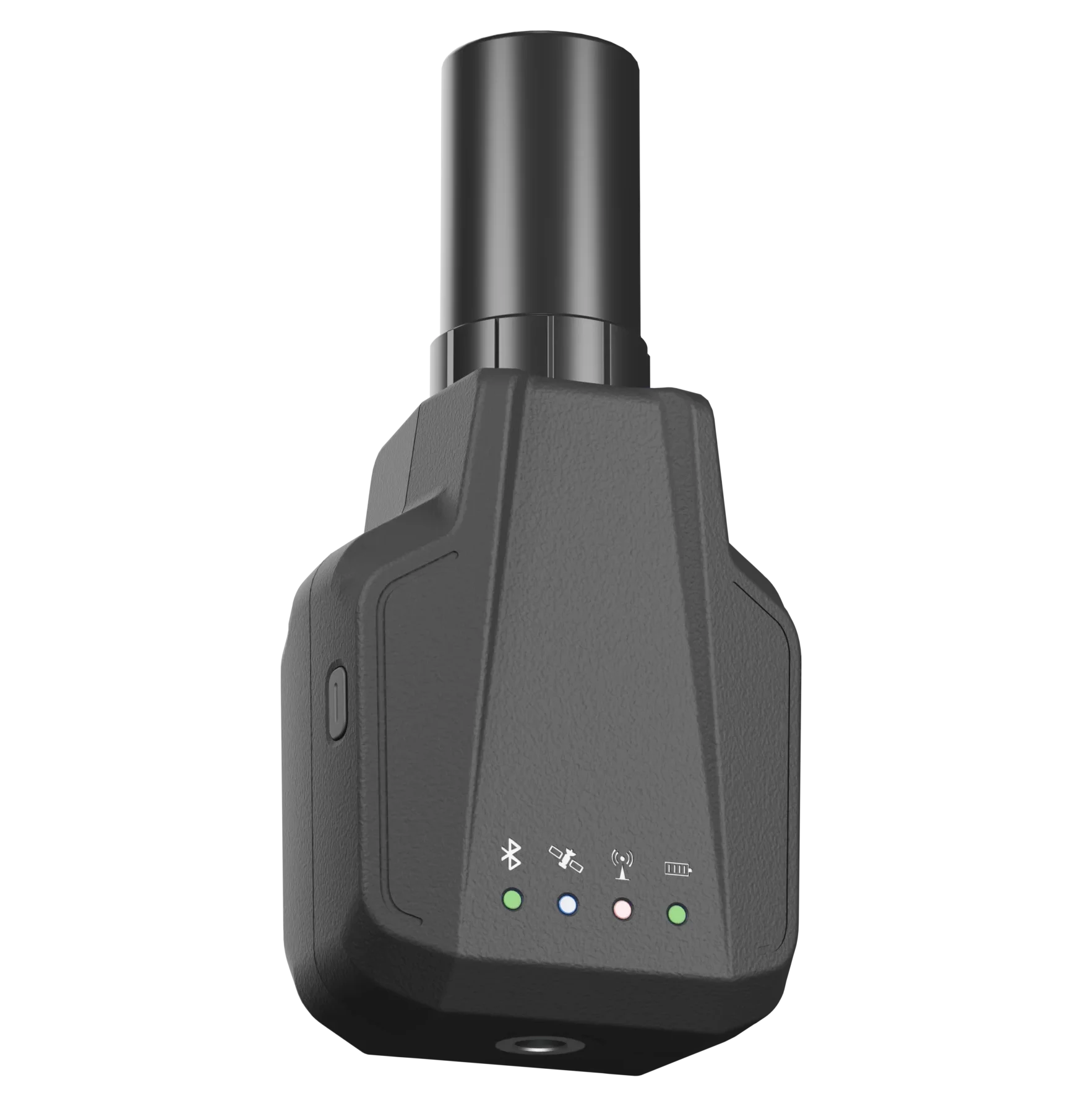
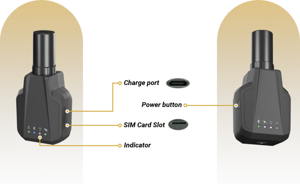
Spherefix SP Nano Compact RTK GNSS Receiver with IMU
This product is available
Get the best price for your setup
Contact our experts for the best possible price and configuration.
The Spherefix SP Nano Compact RTK Receiver is a lightweight, full-constellation GNSS solution for accurate surveying, construction layout and GIS data collection. It combines centimetre-level RTK positioning with real-time IMU tilt compensation, allowing points to be measured efficiently without keeping the survey pole perfectly vertical.
At only 176 g, the SP Nano is easy to carry during long field days while still providing integrated 4G, Bluetooth and more than 12 hours of operating time. Its IP67-rated housing makes it suitable for demanding outdoor work, including road construction, utility surveys, railway stakeout, site levelling and CAD-based layout.
Spherefix SP Nano Highlights
| GNSS tracking | 1,408 channels with GPS, GLONASS, BDS, Galileo, QZSS, SBAS and NavIC |
|---|---|
| RTK accuracy | Horizontal ±(8 mm + 1 ppm); vertical ±(15 mm + 1 ppm) |
| IMU tilt surveying | Less than 2 cm positioning error at up to 60° tilt |
| Connectivity | Integrated 4G and Bluetooth BR+EDR+BLE |
| Weight and runtime | 176 g with more than 12 hours of operation |

Valued customers:










Find RTK Networks
Search NTRIP providers and connect to reliable RTK correction services.
Description
Compact RTK performance for professional fieldwork
The Spherefix SP Nano Compact RTK Receiver is designed for surveyors, engineers, construction professionals and GIS teams that need reliable centimetre-level positioning in a smaller and lighter field package. Its compact dimensions and low 176 g weight make it especially practical for mobile crews, frequent point collection and projects where equipment must be carried throughout the day.
Despite its small format, the receiver tracks signals from the major global satellite constellations across 1,408 channels. Support for GPS, GLONASS, BeiDou, Galileo, QZSS, SBAS and NavIC helps the receiver use a broad range of available satellites, supporting stable positioning across different regions and working environments.
Centimetre-level positioning for layout and measurement
The SP Nano delivers specified RTK accuracy of ±(8 mm + 1 ppm) horizontally and ±(15 mm + 1 ppm) vertically. In practical fieldwork, this makes it suitable for tasks such as construction point layout, road and railway stakeout, utility mapping, site control and accurate GIS feature collection.
The receiver supports common GNSS data and correction workflows, including RTCM 3.X and NMEA-0183. This allows it to fit into professional rover workflows where correction data is supplied through a network RTK service or another compatible correction source.
Measure efficiently with IMU tilt compensation
A built-in high-precision IMU provides real-time tilt compensation. The SP Nano is specified to maintain an error below 2 cm at pole angles of up to 60°. This allows users to collect points without carefully levelling the pole for every measurement.
Tilt surveying is particularly useful near walls, fences, trenches, parked machinery and other obstacles where the pole cannot be placed directly above the required point. It can also make routine topographic and GIS data collection faster by reducing the time spent centring the bubble.
Integrated connectivity for modern RTK workflows
Integrated 4G connectivity enables the receiver to work with mobile correction services without relying entirely on a separate external modem. Bluetooth BR+EDR+BLE provides a wireless connection to compatible field controllers, tablets or data-collection devices.
This combination supports flexible field configurations for construction crews, surveyors and GIS operators. The receiver can form part of a lightweight rover setup for collecting coordinates, setting out design points and transferring positioning information to compatible field software.
Built for long field days
The internal 2,500 mAh battery provides more than 12 hours of stated operating time, helping crews complete a normal working day without changing batteries. Charging is handled through a 5 V/2 A connection, making it easier to recharge the unit using common field power equipment.
The housing is manufactured from PC+ABS and carries an IP67 environmental rating for protection against dust and temporary water immersion. Its specified operating range of -20°C to +60°C supports use across a wide range of outdoor surveying and construction conditions.
Applications
The SP Nano can be used across several accurate positioning workflows. Construction teams can use it for site layout, grading checks and road projects. Surveyors can perform topographic collection, control work and railway stakeout. Utility teams can record power lines, water assets and corridor features, while GIS professionals can collect accurately positioned field data for asset databases and mapping projects.
- Construction layout and site levelling
- Road and railway stakeout
- Power line and utility surveying
- Topographic and cadastral fieldwork
- GIS asset and feature collection
- CAD-based point layout
A lightweight GNSS solution from Global GPS Systems
Global GPS Systems supplies professional GNSS equipment for users who need dependable positioning in real working conditions. The Spherefix SP Nano is a suitable option for buyers looking for a compact RTK rover with tilt compensation, global constellation support and mobile connectivity without the weight of a traditional receiver.
When selecting an RTK configuration, consider the correction service used in your region, the required field controller and software, and whether the receiver will be used primarily for surveying, construction or GIS collection. Global GPS Systems can help match the SP Nano with a suitable field workflow and compatible accessories.
Datasheets & Manuals
Datasheets and manuals
Datasheets & manuals
Specifications
Spherefix SP Nano Compact RTK Receiver Specifications
Product Overview
| Product Type | Compact multi-constellation, multi-frequency GNSS RTK receiver |
|---|---|
| Model | SP Nano |
| Positioning Capability | Centimeter-level real-time kinematic positioning |
| Primary Applications | Land surveying, road construction, power-line surveying, water and utility surveying, GIS data collection, railway stakeout, site-leveling control and CAD layout |
| Key Features | Full-constellation GNSS tracking, 1408 channels, integrated IMU tilt compensation, 4G connectivity, Bluetooth connectivity, compact construction and extended battery operation |
GNSS Receiver
| GNSS Channels | 1408 |
|---|---|
| Supported Constellations | GPS, GLONASS, BeiDou, Galileo, QZSS, SBAS and NavIC |
| GNSS Antenna | Full-band helical antenna |
| Maximum Position Output Rate | 5 Hz |
| Correction Data Support | RTCM 3.x |
| Position Data Format | NMEA 0183 |
| PPP Signal Support | BeiDou B2b-PPP and Galileo E6 PPP signal tracking |
GNSS Signal Tracking
| Constellation | Supported Signals |
|---|---|
| GPS | L1 C/A, L1C, L2C, L2P(Y), L5 |
| GLONASS | G1, G2, G3 |
| BeiDou | B1I, B2I, B3I, B1C, B2a, B2b-PPP |
| Galileo | E1, E5a, E5b, E6-PPP |
| QZSS | L1 C/A, L2C, L5 |
| SBAS | L1 C/A |
| NavIC | Supported |
Positioning Performance
| RTK Horizontal Accuracy | ±(8 mm + 1 ppm) |
|---|---|
| RTK Vertical Accuracy | ±(15 mm + 1 ppm) |
| Tilt Compensation | Real-time IMU-assisted tilt compensation |
| Maximum Compensated Tilt | Up to 60° |
| Tilt Measurement Error | Less than 2 cm within a 60° tilt angle |
| Pole Levelling Requirement | Measurements can be taken without precisely levelling the survey pole when IMU tilt compensation is active |
Processor and Operating System
| Processor | ARM Cortex-A7 |
|---|---|
| Processor Frequency | 1.8 GHz |
| Operating System | Linux |
| Feature Expansion | Supports software and function expansion |
Wireless Communications
| Cellular Connectivity | LTE FDD, LTE TDD, WCDMA and GSM |
|---|---|
| Bluetooth | Bluetooth BR, EDR and BLE |
| Bluetooth Functions | Wireless receiver connection, configuration and field-data communication with compatible devices |
| Remote Connectivity | Supports cloud-linked remote monitoring, configuration and status alerts when used with compatible services |
Cellular Frequency Bands
| Network Type | Supported Bands |
|---|---|
| LTE FDD | B1, B2, B3, B4, B5, B7, B8, B12, B13, B18, B19, B20, B25, B26 and B28 |
| LTE TDD | Supported; available bands may depend on the regional modem configuration |
| WCDMA | B1, B2, B4, B5, B6, B8 and B19 |
| GSM | B2, B3, B5 and B8 |
Power and Battery
| Battery Type | Integrated rechargeable battery |
|---|---|
| Battery Voltage | 3.7 V |
| Battery Capacity | 2500 mAh |
| Operating Time | More than 12 hours |
| Charging Input | 5 V / 2 A |
| Charging Method | USB power charging |
Physical Specifications
| Dimensions | 60 × 41.3 × 126.3 mm |
|---|---|
| Dimension Note | Specified height includes the helical antenna |
| Weight | 176 g |
| Weight Note | Specified weight includes the helical antenna |
| Housing Material | PC+ABS |
| Form Factor | Compact handheld and survey-pole-mounted receiver |
Environmental Specifications
| Ingress Protection | IP67 |
|---|---|
| Dust Protection | Dust-tight enclosure |
| Water Protection | Protected against temporary water immersion under IP67 test conditions |
| Operating Temperature | -20°C to +60°C |
| Storage Temperature | -40°C to +85°C |
Supported Field Workflows
| Road Construction | Point measurement, construction layout and grade-control support |
|---|---|
| Power-Line Surveying | Utility route measurement and asset-position collection |
| Water and Utility Surveying | Infrastructure positioning and field-data collection |
| GIS Data Collection | High-precision geographic feature and asset mapping |
| Railway Stakeout | Track-alignment and construction-point stakeout |
| Site Levelling | Site grading, elevation measurement and control-point workflows |
| CAD Layout | Field layout of coordinates and design points from compatible survey software |
Package Contents
| Item | Quantity | Notes |
|---|---|---|
| SP Nano GNSS RTK Receiver | 1 | Main receiver unit |
| Full-Band Helical Antenna | 1 | GNSS antenna for full-constellation signal reception |
| Plumb-Line Adapter | 1 | Adapter for compatible survey mounting workflows |
| USB Power Adapter | 1 | 5 V / 2 A charging adapter |
Specifications and package contents may vary by configuration, region or manufacturer update. Always check the current configuration before ordering.
FAQ
SP Nano Compact RTK Receiver FAQ
Positioning and Accuracy
What is the SP Nano Compact RTK Receiver?
The SP Nano is a lightweight, professional GNSS receiver designed for centimeter-level positioning in surveying, construction, mapping and engineering workflows. It combines multi-constellation satellite tracking, RTK positioning, an integrated IMU and wireless connectivity in a compact field-ready unit.
What positioning accuracy does the SP Nano provide?
The specified RTK accuracy is ±(8 mm + 1 ppm) horizontally and ±(15 mm + 1 ppm) vertically under suitable operating conditions. Actual accuracy can vary with satellite visibility, correction quality, baseline length, atmospheric conditions and the surrounding environment.
Which satellite constellations does the SP Nano support?
The receiver supports GPS, GLONASS, BeiDou, Galileo, QZSS, SBAS and NavIC. Its 1,408 tracking channels allow it to receive signals from multiple constellations and frequencies simultaneously.
Does the SP Nano support RTK corrections?
Yes. The SP Nano is designed for real-time kinematic positioning and supports RTCM 3.X correction data. It can be used with a compatible GNSS base station, reference-station network or NTRIP correction service, depending on the field setup.
Does the receiver support PPP signals?
The receiver supports relevant PPP signals from BeiDou, Galileo and QZSS. The availability and performance of PPP positioning depend on the correction service, geographic coverage and configured workflow.
What is the maximum positioning update rate?
The SP Nano supports a positioning output rate of up to 5 Hz. This allows the receiver to update its calculated position several times per second for responsive field measurements.
Tilt Measurement and Field Operation
Does the SP Nano have tilt compensation?
Yes. The integrated high-precision IMU provides real-time tilt compensation, allowing measurements to be collected without keeping the survey pole perfectly vertical.
How far can the survey pole be tilted?
The tilt-compensation system is specified to maintain an error below 2 cm at tilt angles of up to 60 degrees under suitable operating conditions. This can make it easier to measure points beside walls, beneath obstacles or in other difficult-to-reach locations.
Does tilt compensation require manual leveling?
Tilt compensation reduces the need to level the pole precisely for every observation. Users should still follow the recommended initialization and operating procedures and confirm that the IMU is ready before recording important points.
Who is the SP Nano designed for?
The receiver is intended for land surveyors, construction professionals, civil engineers, GIS teams, utility surveyors, railway contractors, site supervisors and other users who require portable high-precision GNSS positioning.
Which applications can the SP Nano be used for?
Typical applications include topographic surveying, road construction, power-line surveying, water and utility data collection, GIS mapping, railway stakeout, site-leveling control, CAD layout and general construction positioning.
Can the SP Nano be used near buildings or other obstructions?
The multi-constellation receiver and tilt-compensated measurement system can help users work around some obstacles. However, GNSS performance may still be reduced near tall buildings, dense vegetation, reflective surfaces, bridges or other objects that block or reflect satellite signals.
Connectivity and Compatibility
Does the SP Nano include mobile network connectivity?
Yes. The receiver supports LTE FDD, LTE TDD, WCDMA and GSM mobile network technologies. A compatible SIM card, supported frequency band and active data service may be required for network RTK or cloud-connected functions.
Does the SP Nano support Bluetooth?
Yes. It supports Bluetooth BR, EDR and BLE connectivity. Bluetooth can be used to communicate with compatible field controllers, smartphones, tablets or data-collection software.
Can the SP Nano connect to an NTRIP correction service?
The integrated mobile connectivity allows the receiver to be used in compatible network RTK workflows, including NTRIP-based correction services. Access requires suitable software, network coverage and valid correction-service credentials.
Which data formats does the receiver support?
The SP Nano supports commonly used GNSS formats and protocols, including RTCM 3.X correction data and NMEA-0183 positioning output. Compatibility should be confirmed for the specific controller, application or third-party system being used.
Can the SP Nano be integrated with third-party software?
Integration may be possible through its standard GNSS data formats, Bluetooth connection and network functions. Users should verify supported communication settings, message formats and device compatibility before deployment.
What processor and operating system does the SP Nano use?
The receiver uses a 1.8 GHz ARM Cortex-A7 processor and runs Linux. This processing platform is designed to support positioning functions and potential feature expansion.
Design, Battery and Environmental Protection
How compact is the SP Nano?
The receiver measures approximately 60 × 41.3 × 126.3 mm, including the helical antenna, and weighs approximately 176 g. Its small size is intended for portable survey kits and extended field use.
How long does the battery last?
The integrated 3.7 V, 2,500 mAh battery is specified to provide more than 12 hours of operation. Actual runtime depends on mobile network use, Bluetooth activity, temperature, signal conditions and other operating factors.
How is the SP Nano charged?
The receiver supports 5 V/2 A charging. Use a compatible power source and charging equipment that meet the manufacturer’s electrical requirements.
Is the SP Nano waterproof and dustproof?
The SP Nano has an IP67 environmental protection rating. This means its enclosure is designed to resist dust and temporary water immersion under the conditions defined by the IP67 standard. Ports and covers must be correctly secured to maintain protection.
What temperatures can the SP Nano operate in?
The specified operating temperature range is -20°C to +60°C. The specified storage temperature range is -40°C to +85°C. Battery performance and operating time may decrease in very hot or cold conditions.
What material is the receiver housing made from?
The SP Nano housing is made from PC and ABS materials, providing a balance of low weight and durability for regular outdoor fieldwork.
What accessories are supplied with the SP Nano?
The available product information lists a full-band helical antenna, a plumb-line thread adapter and a 5 V/2 A USB power adapter. Package contents can vary by configuration or region and should be confirmed before deployment.
Reviews (0)
Only logged in customers who have purchased this product may leave a review.
 GPS & GNSS
 Total Stations
 Data collectors
 Software
 Correction services
 Machine control
 External radio
 Lasers & levellers
 Marine
 Accessories
Reviews
There are no reviews yet