
 GPS & GNSS
 Lidar scanning
 Total Station


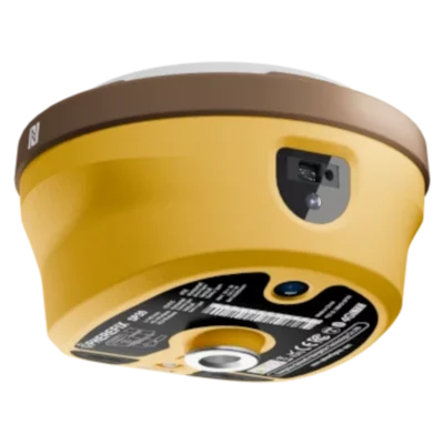
Spherefix SP30 RTK GNSS Rover Base Set with Laser and AR
This product is available
Get the best price for your setup
Contact our experts for the best possible price and configuration.
The Spherefix SP30 Rover and Base Set is a complete two-receiver RTK GNSS system for surveyors, construction teams, engineers, GIS professionals and drone operators. One SP30 operates as the local base station and transmits correction data to the second SP30 used as the rover, allowing centimetre-level positioning without depending entirely on an external RTK correction network.
The rover combines conventional RTK surveying with 60° IMU tilt compensation, AR visual stakeout and camera-assisted laser measurement. Its 1,408-channel GNSS engine tracks multiple frequencies from all major satellite constellations, while the integrated 5 W UHF radio, 4G, Wi-Fi and Bluetooth provide flexible communication options for different field workflows.
Spherefix SP30 Rover and Base Set Highlights
| System configuration | Two Spherefix SP30 receivers for base and rover operation |
|---|---|
| GNSS tracking | 1,408 channels with GPS, GLONASS, BeiDou, Galileo, QZSS, SBAS and NavIC support |
| RTK accuracy | Horizontal ±(8 mm + 1 ppm); vertical ±(15 mm + 1 ppm) RMS |
| IMU tilt surveying | Less than 2 cm stated accuracy within a tilt range of up to 60° |
| Laser surveying | Camera-assisted remote point measurement with stated 3D error of ≤2.5 cm within 5 metres |
| Visual stakeout | Integrated wide-angle camera for AR real-scene stakeout guidance |
| Base-to-rover link | Integrated 410–470 MHz UHF/LoRa radio with adjustable output up to 5 W |
| Additional connectivity | 4G mobile data, Wi-Fi and Bluetooth |

Valued customers:










Find RTK Networks
Search NTRIP providers and connect to reliable RTK correction services.
Description
Complete Spherefix SP30 RTK Rover and Base System
The Spherefix SP30 Rover and Base Set provides two matching multifunctional GNSS receivers for professional base-and-rover surveying. One receiver is installed over a known or newly established reference point and operates as the base station. It calculates correction data and transmits it to the second SP30, which is carried through the project as the rover.
This configuration gives surveyors, construction companies and engineering teams greater control over their RTK workflow. It is particularly useful on sites without access to a suitable NTRIP network, in areas with unreliable mobile coverage or on projects where an independent local correction source is preferred.
Two Matching SP30 GNSS Receivers
Both the base and rover use the same 1,408-channel, multi-frequency GNSS platform. The receivers track signals from GPS, GLONASS, BeiDou, Galileo, QZSS, SBAS and NavIC, giving the system access to a broad range of available satellites.
Using identical receivers simplifies equipment management because either unit can be configured for the required role. Teams can set up one SP30 as the base and the other as the rover, then change the configuration when the project or equipment plan requires it.
Multi-constellation tracking is valuable when part of the sky is obstructed by trees, buildings or machinery. It cannot remove the effects of severe signal blockage or multipath, but it provides more observations for the positioning engine to use under changing field conditions.
Independent Local RTK Corrections
The integrated 410–470 MHz UHF radio supports direct correction transmission between the base and rover. Radio output can be adjusted up to 5 W to suit the working environment, local regulations and required communication range.
A local base-and-rover setup is useful for earthworks, road construction, land development, remote surveying and other projects where mobile data coverage is limited. It can also help organisations avoid relying on a third-party correction service for every job.
The practical radio range depends on antenna height, terrain, buildings, vegetation, interference and the radio settings used. Positioning the base with a clear view and selecting an appropriate radio channel can improve the stability of the correction link.
Centimetre-Level RTK Surveying
The stated RTK accuracy is ±(8 mm + 1 ppm) horizontally and ±(15 mm + 1 ppm) vertically. This makes the system suitable for construction layout, topographic surveys, engineering measurement, utility mapping, as-built recording and ground-control work when the base coordinates and survey configuration are correct.
A base station must be positioned over an accurate reference coordinate when measurements need to match an existing national, local or project coordinate system. Alternatively, it can be established on an arbitrary coordinate for projects where only accurate relative positions are required.
Actual field accuracy depends on satellite visibility, base-coordinate quality, radio or correction stability, baseline length, atmospheric conditions and surrounding reflective surfaces. Good setup procedures remain essential even when using advanced GNSS equipment.
60° IMU Tilt Compensation
The rover’s integrated IMU compensates for pole tilt over a range of up to 60°. The operator can place the pole tip on the required point without carefully levelling the pole before every observation.
This is useful when measuring beside walls, close to buildings, underneath vegetation, around parked machinery or near other physical obstructions. Tilt compensation also speeds up repetitive topographic and construction surveys because fewer movements are needed to centre and level the pole.
The manufacturer states positioning accuracy of less than 2 cm within the supported tilt range under suitable conditions. Correct pole height, calibration, a fixed RTK solution and appropriate field procedures are still required.
Camera-Assisted Laser Measurement
The SP30 includes an integrated laser and aiming camera for measuring locations that are difficult or unsafe to occupy with the pole tip. The operator can stand in a more convenient position, aim at the required feature and record it remotely.
Typical applications include building façades, corners behind barriers, trench edges, raised objects, points near traffic and features on the opposite side of a fence or obstruction. The manufacturer states a three-dimensional laser-measurement error of no more than 2.5 cm at distances within 5 metres under suitable conditions.
Laser measurement extends the range of points that can be collected efficiently, but the operator should choose the measurement method according to the required accuracy, target visibility, surface characteristics and site-safety requirements.
AR Real-Scene Stakeout
A built-in wide-angle camera supports augmented-reality stakeout. The field software can display guidance over the live camera view, helping the operator see the direction of the design point in the actual site environment.
This is easier to interpret than directional values alone, especially on open sites or construction projects containing many closely spaced points. Visual guidance can reduce unnecessary walking and help construction workers or occasional GNSS users follow the stakeout process more confidently.
Flexible 4G and Wireless Connectivity
In addition to the integrated UHF radio, each SP30 provides 4G, Wi-Fi and Bluetooth connectivity. The rover can therefore also receive NTRIP corrections through a mobile network when a compatible correction service is available.
This gives the system two practical operating methods. Teams can use their own SP30 base station for an independent local correction link or operate the rover through an RTK network when that is more convenient. Bluetooth and Wi-Fi support communication with compatible field controllers, software and other equipment.
Designed for Long Field Sessions
The SP30 receivers are designed for extended outdoor operation, allowing the base to remain active while the rover moves around the project. Their rugged construction is intended for everyday surveying environments where equipment may be exposed to dust, moisture and changing weather.
For long or remote projects, teams should still plan charging, backup power and base security carefully. The base receiver normally remains unattended during rover work and should therefore be installed in a stable, protected location where it will not be moved or disturbed.
Practical Applications
- Construction layout and site preparation
- Topographic and engineering surveys
- Road, rail and infrastructure projects
- Earthworks and volume measurement
- Utility and underground-asset mapping
- Land development and cadastral fieldwork
- As-built surveys and quality control
- Ground-control and checkpoints for drone mapping
- GIS data collection in areas without RTK network coverage
Who Uses the SP30 Rover and Base Set
Professional surveyors can use the set for independent field surveys and stakeout projects. Construction teams can establish a base on site and use the rover for foundations, utilities, kerbs, roads and earthworks. Engineers can verify positions and collect as-built data, while GIS teams can map assets in areas where correction-network coverage is unavailable.
Drone operators can use the system to establish accurate ground-control points and independent checkpoints. The two-receiver configuration is also suitable for organisations working across several regions where access to local NTRIP services varies from project to project.
Choosing and Configuring the Complete System
A professional base-and-rover setup requires more than two GNSS receivers. The field configuration may also require a suitable data controller, survey software, rover pole, base tripod or pole, tribrach or adapter, radio antennas and project-specific accessories. The required items depend on the intended workflow and the exact package configuration.
Global GPS Systems can help buyers configure the Spherefix SP30 Rover and Base Set for their coordinate system, field software, radio requirements and surveying application. This helps ensure that the base, rover, controller and accessories work together as a practical field solution.
Datasheets & Manuals
Datasheets and manuals
Datasheet
Specifications
Spherefix SP30 Rover & Base Set Specifications
System Overview
| Product type | Professional RTK GNSS rover and base-station surveying system |
|---|---|
| Receiver model | Spherefix SP30 |
| Receiver quantity | 2 GNSS receivers |
| System configuration | One SP30 configured as a fixed RTK base station and one SP30 configured as a mobile RTK rover |
| Primary applications | Land surveying, topographic surveys, cadastral work, construction layout, stakeout, mapping, earthworks, road projects, utility surveys and geospatial data collection |
| Local RTK operation | Base receiver generates correction data and transmits it directly to the rover receiver |
| Network independence | Can operate with a local base station where an NTRIP or permanent RTK correction network is unavailable or unsuitable |
| Integrated measurement functions | Multi-constellation GNSS positioning, RTK, static surveying, IMU tilt compensation, AR real-scene stakeout and camera-assisted laser measurement |
Receiver Hardware
| Operating system | Linux intelligent system |
|---|---|
| Processor architecture | Qualcomm Cortex-A7 |
| Internal storage | 32GB |
| Available user storage | Approximately 24GB |
| GNSS channels | 1408 high-speed channels |
| Integrated sensors | High-precision inertial measurement unit for tilt-compensated surveying |
| Integrated visual systems | AR stakeout camera and camera-assisted laser measurement system |
| Integrated communications | 4G cellular modem, Wi-Fi, Bluetooth and adjustable-power UHF / LoRa radio |
GNSS Constellations and Signals
| Satellite system | Supported signals | Capability |
|---|---|---|
| GPS | L1C/A, L2P, L2C and L5 | Multi-frequency tracking |
| GLONASS | L1, L2 and L3 | Multi-frequency tracking |
| BeiDou | B1I, B1C, B2I, B2a, B2b and B3I | Multi-frequency tracking |
| Galileo | E1, E5a, E5b and E6 | Multi-frequency tracking |
| QZSS | L1, L2 and L5 | Regional satellite-navigation support |
| SBAS | L1 | Satellite-based augmentation support |
GNSS Data and Performance
| Position data format | NMEA-0183 |
|---|---|
| Correction data format | RTCM 3.x |
| Position update rate | Up to 5Hz according to the published SP30 datasheet |
| Cold-start time | Less than 40 seconds |
| Velocity accuracy | Approximately 0.2m/s |
| Timing accuracy | Approximately 10ns |
| Positioning level | Centimetre-level positioning when operating with suitable RTK corrections and under appropriate satellite conditions |
Positioning Accuracy
| Positioning mode | Horizontal accuracy | Vertical accuracy |
|---|---|---|
| Standalone positioning | 1.5m RMS | 2.5m RMS |
| Differential GNSS | 0.4m RMS | 0.8m RMS |
| RTK positioning | ±(8mm + 1ppm) RMS | ±(15mm + 1ppm) RMS |
| Static surveying | ±(2.5mm + 1ppm) RMS | ±(5mm + 1ppm) RMS |
IMU Tilt Surveying
| Tilt sensor | Integrated high-precision IMU |
|---|---|
| Maximum tilt angle | Up to 60° |
| Tilt-compensated positioning accuracy | Less than 2cm within the supported tilt range under specified operating conditions |
| Pole levelling requirement | Allows points to be measured without keeping the survey pole perfectly vertical |
| Typical benefit | Faster point collection beside walls, buildings, obstacles and uneven terrain |
AR Stakeout and Laser Measurement
| AR stakeout | Integrated camera provides real-scene visual guidance to the selected stakeout point |
|---|---|
| Laser measurement | Integrated camera-assisted laser module for non-contact point measurement |
| Laser targeting | Camera image assists the operator in identifying and aiming at the required point |
| Typical laser applications | Measuring obstructed, elevated, inaccessible or unsafe points that cannot be occupied directly with a survey pole |
| Visual measurement workflow | Combines GNSS, inertial navigation, camera imagery and laser ranging within the receiver |
Rover and Base Operation
| Function | Base receiver | Rover receiver |
|---|---|---|
| Primary role | Fixed reference station | Mobile positioning receiver |
| GNSS operation | Calculates correction data from a known or established position | Applies received corrections to calculate centimetre-level coordinates |
| Radio function | Transmits RTK correction data | Receives RTK correction data |
| Visual functions | Normally not required during fixed base operation | Supports AR stakeout and camera-assisted laser measurement |
| IMU function | Normally not required during fixed base operation | Supports tilt-compensated pole surveying up to 60° |
| Interchangeability | The two SP30 receivers use the same receiver platform and can be assigned as rover or base according to the field setup | |
UHF / LoRa Radio
| Radio type | Integrated adjustable-power UHF / LoRa transceiver |
|---|---|
| Frequency range | 410–470MHz |
| Selectable transmit power | 0.5W, 2W or 5W |
| Maximum transmit power | 5W |
| Air baud rates | 9600bps and 19200bps |
| Supported radio protocols | TRIMTALK, TRIMMK3, SOUTH and TRANSEOT |
| Maximum stated range | Up to 16km in an open area when the base operates at maximum transmit power |
| Range limitations | Actual range varies according to terrain, obstructions, antenna position, interference, receiver height and local radio regulations |
Cellular and Wireless Connectivity
| Cellular modem | Integrated 4G full-network modem |
|---|---|
| LTE FDD bands | B1, B2, B3, B4, B5, B7, B8, B12, B13, B18, B19, B20, B25, B26 and B28 |
| LTE TDD bands | B38, B39, B40 and B41 |
| WCDMA bands | B1, B2, B4, B5, B6, B8 and B19 |
| GSM bands | B2, B3, B5 and B8 |
| Wi-Fi | IEEE 802.11 b/g/n |
| Bluetooth | Bluetooth BR, EDR and BLE |
| Network RTK | Supports internet-delivered correction data through a compatible cellular connection and surveying application |
| Combined antenna | Integrated antenna assembly for GNSS, Wi-Fi, Bluetooth and 4G communications |
Correction Methods
| Correction method | Connection | Typical use |
|---|---|---|
| Local radio RTK | Integrated 410–470MHz radio | Direct correction transmission from the SP30 base to the SP30 rover |
| Network RTK | 4G internet connection | Corrections received from an NTRIP or compatible RTK network |
| Static surveying | Internally recorded GNSS observations | Post-processed control, reference and high-accuracy survey observations |
| Differential GNSS | Compatible differential correction source | Sub-metre positioning where full RTK accuracy is not required |
Receiver Battery and Power
| Battery type | Integrated high-capacity rechargeable lithium battery |
|---|---|
| Continuous operation | More than 24 hours under the operating conditions stated for the rover and base set |
| Static data-logging endurance | Up to approximately 26 hours under the datasheet test conditions |
| Fast charging | Supported with a compatible fast-charging adapter |
| Power-management function | Charging current is adjusted according to the connected power source and battery condition |
| Battery-life variables | Operating time varies with radio transmit power, cellular use, satellite tracking, temperature, battery condition and receiver mode |
Status Indicators
| Power indicator | Displays receiver power and battery status |
|---|---|
| Position indicator | Displays GNSS positioning status |
| Differential-data indicator | Displays correction-data or radio-link activity |
| Wireless status | Connection status can be monitored through the receiver indicators and compatible field software |
Environmental Specifications
| Ingress protection | IP68 |
|---|---|
| Dust protection | Dust-tight enclosure |
| Water protection | Water-resistant enclosure designed to meet the stated IP68 requirements |
| Housing material | Solid magnesium-alloy shell |
| Field environment | Designed for outdoor surveying in rain, dust, construction environments and rugged terrain |
| Environmental limitation | Environmental protection depends on correctly closed covers, undamaged seals and proper maintenance |
Set Capabilities
| Independent correction source | Provides a movable local RTK reference station for projects without reliable network corrections |
|---|---|
| Receiver role flexibility | Either receiver can be assigned to rover or base operation according to the project setup |
| Long-range correction link | Integrated 5W radio supports extended base-to-rover communication in suitable open conditions |
| Alternative correction source | The rover can also use network RTK corrections through its integrated 4G modem |
| Extended field operation | High-capacity batteries support full-day and multi-shift surveying workflows under suitable operating conditions |
| Challenging-point measurement | IMU tilt compensation and laser measurement reduce the need to position the pole directly over every measured point |
Package Contents
| Item | Quantity | Notes |
|---|---|---|
| Spherefix SP30 GNSS receiver | 2 | One receiver can be configured as the RTK base and the second as the RTK rover |
| GNSS controller | Configuration-dependent | Controller model and inclusion should be confirmed for the selected set configuration |
| Survey software | Configuration-dependent | Software application, license type and subscription period may vary |
| Rover pole and controller bracket | Configuration-dependent | Confirm the pole material, length and mounting accessories supplied |
| Base tripod, tribrach and adapter | Configuration-dependent | Base-station mounting equipment may vary by selected package |
| Radio antenna and accessories | Configuration-dependent | Frequency and antenna configuration must comply with regional radio regulations |
| Chargers and cables | Configuration-dependent | Power adapters, charging cables and connector types may vary by region |
| Transport cases | Configuration-dependent | Case quantity and internal layout depend on the selected set |
Specifications and package contents may vary by configuration, region or manufacturer update. Always check the current configuration before ordering.
FAQ
Spherefix SP30 Rover Base Set FAQ
System Overview and Applications
What is the Spherefix SP30 Rover Base Set?
The Spherefix SP30 Rover Base Set is a professional RTK GNSS surveying system that uses two SP30 receivers. One receiver operates as the base station and transmits correction data, while the second operates as the rover for centimetre-level field measurements.
Who is the SP30 Rover Base Set designed for?
The system is designed for land surveyors, civil engineers, construction contractors, utility companies, mapping professionals, agricultural specialists and other users who require precise positioning without relying entirely on a third-party RTK network.
Which surveying jobs can be completed with this rover and base set?
The set can be used for topographic surveys, cadastral measurements, construction stakeout, road and infrastructure projects, utility mapping, earthworks, as-built surveys, control-point establishment and geospatial data collection.
What is the advantage of using a separate GNSS base station?
A local base station generates RTK corrections from a known or established position and sends them directly to the rover. This allows accurate surveying in locations where mobile coverage or an NTRIP correction service is unavailable, unreliable or unsuitable for the project.
Can either SP30 receiver be used as the base or rover?
Yes. The SP30 is designed to support both base and rover operation. The roles can be assigned through compatible field software, allowing the two receivers to be configured according to the requirements of each project.
Does the set require a separate RTK correction subscription?
A correction subscription is generally not required when one SP30 is used as a local base station and corrections are transmitted directly to the rover. A subscription may still be useful when the rover is operated independently through an NTRIP or CORS network.
Accuracy and Surveying Features
What positioning accuracy can the SP30 Rover Base Set achieve?
Under suitable RTK conditions, the SP30 is designed to provide centimetre-level positioning. Published specifications indicate RTK accuracy of approximately 8 mm plus 1 ppm horizontally and 15 mm plus 1 ppm vertically. Actual accuracy depends on satellite visibility, base position, baseline length, radio quality and the surrounding environment.
Which satellite constellations does the SP30 support?
The SP30 tracks multiple frequencies from GPS, GLONASS, Galileo and BeiDou. Tracking several constellations simultaneously improves satellite availability, initialization speed and positioning reliability in demanding field conditions.
How many GNSS channels does each SP30 receiver have?
Each SP30 receiver has 1,408 high-speed GNSS channels for tracking multiple satellite constellations and frequencies simultaneously.
Does the SP30 support tilt-compensated measurements?
Yes. The integrated inertial measurement unit supports pole-tilt compensation up to approximately 60 degrees. This allows the rover operator to measure points without keeping the survey pole perfectly vertical.
What is AR real-scene stakeout?
AR real-scene stakeout uses the SP30 camera and compatible field software to display navigation guidance over a live view of the site. This helps the operator identify the direction and location of a stakeout point more intuitively than conventional directional indicators alone.
Can the SP30 measure points that cannot be occupied with a survey pole?
Yes. The SP30 includes a camera-assisted laser measurement function for collecting certain inaccessible, obstructed or potentially unsafe points. Measurement performance depends on target visibility, distance, reflectivity, aiming stability and environmental conditions.
Base-to-Rover Communication and Workflow
How are RTK corrections transmitted from the base to the rover?
The base receiver can transmit correction data to the rover through the integrated 410–470 MHz radio. The system also supports 4G, Wi-Fi and Bluetooth for compatible network, controller and data-transfer workflows.
What is the maximum radio range between the base and rover?
The integrated radio can provide a range of up to approximately 16 km under favourable open conditions. The practical range may be reduced by terrain, vegetation, buildings, interference, antenna height, radio settings and local transmission restrictions.
Does each SP30 include an internal UHF radio?
Yes. Each SP30 includes an internal radio operating within the 410–470 MHz frequency range, with selectable transmission power of up to 5 W. The selected frequency and power must comply with local radio regulations.
Can the rover also receive corrections through NTRIP?
Yes. The SP30 supports 4G connectivity and can receive network RTK corrections through a compatible NTRIP or CORS service when configured with suitable field software, mobile data access and valid correction-service credentials.
How should the SP30 base station be positioned?
The base should be installed securely over a stable point with a clear view of the sky. For accurate absolute coordinates, the base must use a known control point or have its position established using an appropriate surveying method.
Can the system be used without mobile phone coverage?
Yes. When the base transmits corrections directly to the rover through the internal radio, the system can operate without mobile internet coverage. Mobile connectivity may still be required for cloud services, online maps or remote data transfer.
Power, Durability and Equipment Requirements
How long can the SP30 receivers operate on one charge?
Each SP30 has a large-capacity internal battery and is designed for more than 24 hours of rover operation under typical conditions. Base-station runtime may be shorter when the internal radio is continuously transmitting at high power.
Can the SP30 receivers be powered externally?
Yes. The SP30 supports USB charging and an external DC power supply. External power can be useful for long-duration base-station operation, provided a compatible power source, charger and cable are used.
Are the SP30 receivers waterproof and dustproof?
Yes. The receivers have an IP68-rated enclosure designed for demanding outdoor surveying conditions. Connection ports and protective covers must be properly closed to maintain the stated resistance to water and dust.
Can the receivers withstand drops and rough field use?
The SP30 uses a rugged magnesium-alloy housing and is specified to withstand a 1.5-metre pole drop at room temperature. Careful handling, secure mounting and suitable transport protection are still recommended.
What additional equipment is needed to use the rover and base set?
A typical setup requires a field controller with compatible surveying software, a rover pole, a tripod or fixed base support, a tribrach or suitable mounting adapter, charging equipment and any required radio antennas or controller brackets. Exact package contents should be checked before ordering.
Can the SP30 Rover Base Set be used with third-party field software?
The receivers support commonly used communication and correction formats, including RTCM and NMEA. Compatibility with a particular controller, surveying application, coordinate system or office workflow should be confirmed before deployment.
Reviews (0)
Only logged in customers who have purchased this product may leave a review.
 GPS & GNSS
 Total Stations
 Data collectors
 Software
 Correction services
 Machine control
 External radio
 Lasers & levellers
 Marine
 Accessories
Reviews
There are no reviews yet