33%

South Geomatics Office
Login to view prices
Click here to login or register

Worldwide Shipping From The Netherlands
100% Shipping Insurance on Damage and Loss
Experts in Import / Export / Tax and Duties
Premium Support from Product Experts
Buyers Protection and Warranty on all Products
Global GPS Systems
What Our Clients Say
Need Help? Call us!
+31 (0)35 205 7939
South Geomatics Office
Login to view prices
Click here to login or register
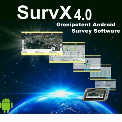
SGO is equipped with more than ten tools such as CAD, coordinate conversion, road design, instar, decoder, Data QC, Torinex, and antenna management. Install one software to meet almost any geographic data processing needs.
Datasheets and manuals
Datasheet
RECOMMENDED DATA COLLECTORS:


Login to view prices
Click here to login or register
Click here to login or register


Login to view prices
Click here to login or register
Click here to login or register


Login to view prices
Click here to login or register
Click here to login or register

Login to view prices
Click here to login or register
Click here to login or register

Login to view prices
Click here to login or register
Click here to login or register
RECOMMENDED SOFTWARE:
Login to view prices
Click here to login or register
Click here to login or register
38%

Login to view prices
Click here to login or register
Click here to login or register
25%

Login to view prices
Click here to login or register
Click here to login or register

Login to view prices
Click here to login or register
Click here to login or register
Login to view prices
Click here to login or register
Click here to login or register

Login to view prices
Click here to login or register
Click here to login or register
RECOMMENDED ACCESSORIES:
Login to view prices
Click here to login or register
Click here to login or register


Login to view prices
Click here to login or register
Click here to login or register

Login to view prices
Click here to login or register
Click here to login or register


Login to view prices
Click here to login or register
Click here to login or register


Login to view prices
Click here to login or register
Click here to login or register

Login to view prices
Click here to login or register
Click here to login or register


Thomas Sacher (verified owner) –
Grundsätzlich ok, macht was es soll, leider nur englisch und chinesisch .