


 GPS & GNSS
 Lidar scanning
 Total Station
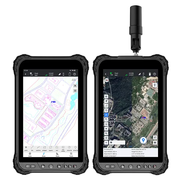
South N80 Rugged Android 8″ Survey Data Collector Tablet
Get the best price for your setup
Contact our experts for the best possible price and configuration.
- Fast response
- Expert configuration advice
- No overpaying for features you do not need
The SOUTH N80 is a rugged Android GNSS tablet for field data collection, GIS mapping, construction layout, utility surveys and land surveying. Its integrated high-precision GNSS receiver and sensitive antenna support differential positioning workflows, while 4G, Wi-Fi and Bluetooth keep field data connected to office systems and correction services. The bright 8-inch touchscreen gives surveyors and construction crews a practical view of maps, forms and measurement points in the field. With an IP67-rated enclosure, 15-hour battery and built-in cameras, the N80 is suited to demanding outdoor work such as infrastructure inspection, utility mapping, agricultural surveying and site documentation. It can also connect with compatible RTK equipment or an external GNSS antenna when higher positioning performance is required.
SOUTH N80 Highlights
| GNSS | Integrated receiver; GPS, GLONASS, Galileo and BeiDou; 72 channels |
|---|---|
| Positioning | Supports differential positioning workflows and centimeter-level RTK applications with suitable corrections |
| Display | 8-inch HD touchscreen, 1280 × 800 resolution |
| Connectivity | 4G cellular, dual-band Wi-Fi, Bluetooth, USB Type-C and NFC |
| Rugged design | IP67 dust and water protection; operating temperature from -20°C to 60°C |
| Battery | 8,200mAh removable Li-ion battery with over 15 hours of continuous use |
Valued customers:










Find RTK Networks
Search NTRIP providers and connect to reliable RTK correction services.
Description
SOUTH N80 Rugged GNSS Tablet for GIS and Field Mapping
The SOUTH N80 is an industrial-grade Android GNSS tablet designed for surveyors, construction teams, GIS professionals, utility inspectors, agricultural users, and other field crews who need reliable positioning and a large screen for collecting and reviewing spatial data. It combines a rugged touchscreen tablet, integrated GNSS positioning, mobile connectivity, wireless communication, cameras, and long battery life in one portable field device.
Unlike a small handheld data collector that can make maps, forms, drawings, and inspection records difficult to view, the N80 provides an 8-inch display with a 1280 × 800 resolution. This gives field users more room to work with digital plans, GIS layers, asset databases, inspection forms, construction drawings, and mapping applications. The larger screen is particularly useful when checking features against a background map, reviewing collected points, navigating between work areas, or entering detailed notes while standing on a jobsite.
Built for Practical GNSS and GIS Fieldwork
The N80 includes an integrated GNSS board and a sensitive internal antenna for satellite-based positioning. It supports GPS, GLONASS, and Galileo signals, allowing the tablet to determine its position in a wide range of outdoor working environments. The N80 is intended for general-purpose professional positioning, GIS data collection, asset inventory, site documentation, route recording, and mapping tasks where a rugged Android tablet is more useful than a standard consumer device.
In practical fieldwork, the N80 can help crews locate and record utility assets, inspect infrastructure, document construction progress, map land features, navigate to previously recorded locations, and attach photographs or notes to mapped points. It can also support applications that use external correction services or connected surveying equipment, depending on the software and field setup being used. Positioning performance will vary with satellite visibility, obstructions, multipath, correction sources, application settings, and the requirements of the work.
The N80 should be viewed as a rugged GNSS-enabled field tablet rather than a dedicated centimeter-level RTK rover. For high-precision stakeout, boundary work, machine control, or survey tasks that require centimeter accuracy, a dedicated RTK receiver such as the SOUTH N80T or another professional RTK GNSS system is normally the more appropriate choice. The N80 is better suited to GIS, mapping, inspection, navigation, asset collection, and field documentation where a larger Android interface and integrated communications are the main priorities.
Large Touchscreen for Maps, Forms, and Construction Data
Field crews often work with applications that contain more information than a compact controller can display comfortably. The N80’s 8-inch capacitive touchscreen provides a practical working area for viewing maps, navigating menus, measuring distances in software, completing digital inspection forms, reviewing photographs, and checking design information. Multi-touch operation makes it easier to zoom into map features, pan across a project area, and work with Android-based surveying, GIS, construction, and inspection applications.
The display is protected by Corning Gorilla Glass and is designed for outdoor use with a bright 700-nit screen. This can make map and form information easier to see in daylight compared with ordinary office tablets, although direct sunlight, viewing angle, screen settings, and the application interface will still affect visibility. The screen size also helps reduce the need to constantly zoom and scroll when working with larger project files or detailed utility maps.
Rugged Design for Construction and Utility Environments
The SOUTH N80 is built for field conditions where equipment may be exposed to dust, moisture, vibration, accidental drops, and changing temperatures. Its IP67 protection helps protect the device from dust ingress and temporary water exposure when the appropriate covers are closed. The tablet is also specified for a 1.2-meter drop and MIL-STD-810G-related ruggedness testing, making it more suitable for construction sites, roadsides, utility corridors, agricultural land, and other demanding work areas than a typical consumer tablet.
The operating temperature range is specified from -20°C to 60°C, which supports use in many hot and cold outdoor environments. Rugged construction does not eliminate the need for sensible handling, however. The device should still be protected from prolonged immersion, high-pressure water, severe impacts, chemical exposure, and conditions outside its rated limits. Keeping the screen, charging port, SIM slots, and protective covers clean is important for dependable day-to-day use.
Connectivity for Connected Field Teams
Integrated cellular communication allows the N80 to connect to mobile networks for internet access, cloud services, online maps, corrections, file transfer, reporting, and communication between the field and office. The tablet supports a broad range of cellular bands and includes two nano-SIM slots, which can be useful for organizations that work across different regions or need a backup connection. Actual network availability depends on the carrier, coverage, SIM configuration, subscription, and local frequency support.
Dual-band Wi-Fi supports connection to office networks, mobile hotspots, and other compatible wireless infrastructure. Bluetooth provides a convenient way to connect with compatible GNSS accessories, measuring devices, barcode equipment, computers, and other field peripherals. NFC support can also be useful for identification, pairing, reading tags, or integrating the tablet into asset-management workflows where the application supports NFC functions.
The USB Type-C connection supports charging, data transfer, and OTG functions. This gives teams more flexibility when moving files, connecting compatible accessories, transferring project information, or integrating the tablet into existing field workflows. As with any Android field device, compatibility depends on the application, cable, accessory, and operating-system support.
Android Platform for Flexible Survey and GIS Applications
Running Android 12, the N80 can support a wide range of compatible mapping, inspection, construction, surveying, navigation, and asset-management applications. Its octa-core processor, 6 GB of RAM, and 128 GB of internal storage provide a practical platform for field software, digital documents, photographs, offline map areas, and collected project data. Storage can be expanded with a supported TF card, which is helpful for users working with larger image libraries, offline datasets, or multiple projects.
Because the N80 uses Android, organizations can select software based on their workflow instead of being restricted to a single proprietary field application. It can be configured for GIS data collection, utility inventory, environmental surveys, construction reporting, land management, road inspections, agricultural mapping, and field service operations. Before purchase, buyers should confirm that their preferred software supports the N80’s Android version, GNSS functions, required coordinate systems, correction workflow, and any external equipment they plan to connect.
Integrated Cameras for Site Documentation
The N80 includes a 16-megapixel autofocus rear camera with flash and an 8-megapixel front camera. The rear camera can be used to document site conditions, utility installations, construction progress, damaged infrastructure, survey control points, assets, and inspection findings. Photographs can be associated with mapped features or records when supported by the field application, helping teams create a clearer connection between location data and visual evidence.
For construction workers and inspectors, this can reduce the need to carry a separate camera for routine documentation. Surveyors and GIS users can also use photographs to support asset records, maintenance reports, environmental observations, and field verification. Camera quality and geotagging behavior will depend on the application and operating settings, so photographs should be checked before being used as formal project evidence.
Long Battery Life for Full-Day Field Operations
The removable 9000 mAh lithium-ion battery is designed to provide a minimum of approximately 15 hours of operation under specified conditions. In real field use, battery life will depend on screen brightness, cellular coverage, GNSS activity, Bluetooth, Wi-Fi, camera use, processing load, temperature, and the applications running in the background. Even so, the capacity is intended to support extended work shifts and reduce interruptions caused by frequent charging.
Quick charging support can help crews return the tablet to service during breaks or between site visits. The removable battery design may also be useful for organizations that maintain spare batteries for longer field days, rotating crews, remote locations, or projects where access to power is limited. Charging time is approximately three to four hours under the stated conditions.
Useful Applications Across Surveying, Construction, and GIS
The SOUTH N80 is suited to professionals who need a durable Android tablet with integrated positioning rather than a lightweight office tablet or a dedicated high-precision RTK receiver. Typical applications include collecting GIS points and attributes, mapping roads and public assets, documenting utility networks, inspecting electrical infrastructure, recording gas and pipeline assets, checking construction locations, supporting land surveys, and maintaining field service records.
In construction, the N80 can be used for site documentation, plan viewing, asset location, progress records, field reports, and coordination between workers and project offices. In GIS, it can support feature collection, database updates, visual verification, and offline mapping workflows. For utilities, the tablet can help crews record poles, cables, cabinets, pipelines, valves, meters, and inspection observations. In agriculture and land management, it can assist with field boundaries, land-use records, infrastructure mapping, and crop-related documentation.
The integrated digital compass, gyroscope, gravity sensor, and ambient-light sensor can support applications that use device orientation, motion, display adjustment, or field navigation. These sensors do not replace professional survey procedures, but they can make the tablet more useful for inspections, navigation, visual documentation, and interactive mapping.
Why Choose the N80 for Professional Field Data Collection?
- Rugged IP67 Android tablet designed for demanding outdoor work.
- Integrated GNSS positioning for mapping, navigation, GIS, and asset collection.
- Large 8-inch touchscreen for digital maps, drawings, forms, and field records.
- Mobile, Wi-Fi, Bluetooth, NFC, and USB Type-C connectivity for flexible workflows.
- High-capacity removable battery for extended field operation.
- Integrated cameras for photographs, inspections, and construction documentation.
- Android 12 platform with storage capacity for applications and project files.
A Practical Choice for Connected Field Mapping
The SOUTH N80 is a versatile field tablet for organizations that need more than a standard Android device but do not require a dedicated centimeter-level RTK rover for every task. Its combination of GNSS positioning, rugged protection, large touchscreen, cellular communication, cameras, and long battery life makes it useful for mobile GIS, construction documentation, utility inspection, asset management, transportation work, land mapping, and field service applications.
When selecting the N80, consider the accuracy required for your project, the GNSS correction method used by your software, cellular coverage at the worksite, the size of your mapping datasets, and whether your workflow requires an external antenna or RTK receiver. For general field mapping and data collection, the N80 provides a durable and flexible platform that can be configured around the software and procedures already used by your team.
Buy the SOUTH N80 from Global GPS Systems
Global GPS Systems supplies professional surveying equipment, GNSS receivers, rugged controllers, GIS devices, accessories, and related field technology for construction, surveying, mapping, utilities, drone operations, and other technical industries. If you are comparing the SOUTH N80 with a dedicated RTK controller, handheld GIS unit, or higher-precision GNSS rover, Global GPS Systems can help you assess which equipment best matches your required accuracy, software, connectivity, and field conditions.
Datasheets & Manuals
Specifications
N80 Specifications
Product Overview
| Product type | Industrial rugged GNSS tablet and field data-collection terminal |
|---|---|
| Manufacturer | SOUTH Surveying & Mapping Technology Co., Ltd. |
| Model | N80 |
| Primary purpose | Mobile surveying, mapping, GIS data collection, positioning, inspection and field-data management |
| Integrated positioning hardware | Integrated GNSS board and high-sensitivity antenna |
| Field connectivity | 4G cellular modem, Wi-Fi, Bluetooth, USB Type-C and dual SIM support |
| Ruggedization | IP67 water and dust protection with resistance to drops from up to 1.2 m onto concrete |
Operating System and Processing
| Operating system | Android 12 |
|---|---|
| Processor | Qualcomm octa-core processor |
| Processor speed | Published configurations include octa-core processors at 1.5 GHz and 2.0 GHz |
| RAM | Published configurations include 3 GB and 6 GB |
| Internal storage | Published configurations include 64 GB and 128 GB ROM |
| Storage expansion | TF or microSD card expansion supported; published documentation specifies up to 128 GB additional storage |
| Software compatibility | Designed for Android-based surveying, mapping, GIS, inspection and data-collection applications |
| RINEX support | Supported by the published N80/N80T brochure configuration |
GNSS and Positioning
| Positioning function | N80 specification | N80T reference variant |
|---|---|---|
| GNSS channels | 72 channels | 1,408 channels |
| Supported satellite systems | GPS, GLONASS and Galileo | GPS, GLONASS, Galileo, BeiDou, QZSS and SBAS |
| Published satellite signals | Not fully specified in the current product listing | GPS L1C/A, L1C and L2C; GLONASS L1 and L2; Galileo E1, E5A and E5B; BeiDou B1I, B2I, B3I, B1C and B2A; QZSS L1C/A and L2C; SBAS L1C/A |
| Autonomous positioning accuracy | Approximately 2 m to 5 m, depending on configuration and conditions | Approximately 1.5 m |
| SBAS accuracy | Approximately 1 m to 3 m in the published brochure configuration | Not separately specified |
| DGNSS accuracy | Approximately 1 m CEP in the published brochure configuration | Approximately 0.5 m CEP |
| Single-baseline RTK | Not supported in the published N80 configuration | Approximately 1 cm + 1 ppm |
| Differential positioning formats | RTD in the published brochure configuration | RTCM 3.0 and RTCM 3.2 |
| External GNSS antenna | Not supported in the published N80 configuration | Supported |
| Positioning technology | Integrated GNSS positioning with differential-positioning support in applicable configurations | Multi-constellation, multi-frequency GNSS with RTK support |
Cellular and Wireless Communication
| SIM configuration | Dual nano SIM card slots |
|---|---|
| Cellular modem | 4G TD-LTE and FDD-LTE modem with backward compatibility for supported 3G and 2G networks |
| GSM bands | 850, 900, 1800 and 1900 MHz |
| CDMA band | BC0 |
| EVDO band | BC0 |
| WCDMA bands | B1, B2, B5 and B8 |
| TD-SCDMA bands | B34 and B39 |
| TDD-LTE bands | B38, B39, B40 and B41 |
| FDD-LTE bands | B1, B2, B3, B4, B5, B7, B8, B17, B20 and B28 |
| Wi-Fi | IEEE 802.11 a/b/g/n/ac with 2.4 GHz and 5 GHz support |
| Bluetooth | Bluetooth 4.2 in the current manufacturer specification; earlier brochure configurations list Bluetooth 2.1 + EDR, 3.0 + HS and 4.1 compatibility |
| NFC | Supported |
| Cloud connectivity | Supports connected device management, location and track uploading, and cloud storage functions through compatible SOUTH cloud services |
Display and User Interface
| Display size | 8 inches |
|---|---|
| Display type | Color TFT or high-definition touchscreen display, depending on configuration |
| Standard resolution | 1280 × 800 pixels; earlier documentation lists 800 × 1280 pixels |
| Optional resolution | 1920 × 1200 pixels on applicable configurations |
| Brightness | Up to 500 nits on the current manufacturer specification |
| Touchscreen | Integrated touchscreen for field operation and data entry |
| Physical buttons | Volume down, volume up, menu, home, back, A1, A2 and power buttons |
| Audio | Integrated speaker and microphone |
Camera and Multimedia
| Rear camera | 16.4 megapixel autofocus rear camera in the current manufacturer specification; earlier brochure configurations list a 13 megapixel autofocus rear camera |
|---|---|
| Front camera | 8 megapixels in the current manufacturer specification; earlier brochure configurations list a 5 megapixel front camera |
| Rear camera flash | Integrated flashlight or flash support |
| Typical field uses | Geotagged documentation, asset records, inspection photographs, mapping evidence and field survey notes |
Sensors
| G-sensor | Supported |
|---|---|
| Gyroscope | Supported on applicable configurations |
| Accelerometer | Three-axis acceleration sensor on applicable configurations |
| Electronic compass | Supported |
| Light sensor | Supported |
| Atmospheric pressure sensor | Supported in published brochure configurations |
| Proximity sensor | Supported on applicable configurations |
| Rotation vector sensor | Supported on applicable configurations |
| Distance sensor | Optional on applicable configurations |
Ports, Slots and Expansion
| USB connector | USB Type-C |
|---|---|
| USB function | Supports OTG for compatible peripherals and data-transfer accessories |
| SIM slots | Two nano SIM card slots |
| Memory card slot | One TF or microSD card slot, depending on configuration |
| Expansion functions | NFC, customizable barcode scanning and infrared scanning support on applicable configurations |
| Data-transfer methods | USB Type-C, Wi-Fi, Bluetooth, cellular network and compatible cloud services |
Battery and Power
| Battery type | Removable rechargeable lithium-ion battery |
|---|---|
| Battery voltage | 3.8 V |
| Published battery capacity | 7,000 mAh in the original N80 brochure; other N80-series documentation references an 8,000 mAh battery |
| Typical operating time | More than 15 hours under typical conditions |
| Battery replacement | Removable battery design supports field replacement where compatible spare batteries are available |
Environmental and Ruggedness
| Ingress protection | IP67 |
|---|---|
| Water protection | Protection against temporary immersion according to the IP67 rating when all covers and seals are correctly installed |
| Dust protection | Dust-tight enclosure according to the IP67 rating |
| Drop resistance | Up to 1.2 m onto concrete in the published manufacturer specification |
| Military standard | N80/N80T current manufacturer listing references MIL-STD-810G certification |
| Operating temperature | -20°C to 60°C |
| Storage temperature | -30°C to 70°C in the current manufacturer specification; earlier brochure documentation lists -40°C to 80°C |
| Operating humidity | 5% to 95% relative humidity, non-condensing |
Physical Specifications
| Dimensions | 245 × 152 × 18 mm in the current manufacturer specification; earlier brochure documentation lists 258 × 147 × 15 mm |
|---|---|
| Weight | Approximately 650 g for the current N80 configuration; earlier brochure documentation lists approximately 520 g |
| N80T reference weight | Approximately 750 g |
| Form factor | Handheld rugged tablet designed for field use |
Supported Industries and Users
| Land surveying and mapping | Surveyors, GIS technicians, mapping teams and geospatial professionals collecting points, attributes, photographs and inspection records |
|---|---|
| Agriculture and land management | Land-use change surveys, agricultural mapping, land approval surveys and illegal land-use monitoring |
| Electric utilities | GIS data collection, power-line safety inspections, electrical-equipment maintenance and pylon-position surveys |
| Transportation | Intelligent transportation projects, roadside asset mapping, transportation infrastructure surveys and travel-guidance data collection |
| Fuel and gas utilities | Gas-pipeline network data collection, pipeline safety inspections and positioning of key equipment |
| Construction and engineering | Site documentation, asset positioning, field verification, progress records and construction GIS workflows |
| Public works and municipal services | Infrastructure inventories, utility mapping, maintenance inspections and location-based field reporting |
| Environmental and natural-resource management | Field observations, land surveys, environmental inventories and location-based inspection workflows |
Common Functions
| GIS data collection | Collection and management of location-linked points, lines, polygons, attributes and photographs |
|---|---|
| Field mapping | Large-screen map viewing and data entry for outdoor mapping applications |
| Asset inspection | Location-based inspection records for utilities, infrastructure, equipment and public assets |
| Differential positioning | Supports differential GNSS workflows on applicable configurations |
| RTK positioning | Available on the N80T variant; not specified for the standard N80 configuration |
| Geotagged photography | Front and rear camera support for field evidence and documentation |
| Cloud-based device management | Compatible SOUTH cloud functions can provide device tracking, real-time position uploads and cloud storage |
| Barcode and NFC workflows | Supports NFC and configurable barcode or infrared-scanning extensions on applicable configurations |
Package and Included Items
| Item | Quantity | Notes |
|---|---|---|
| N80 tablet | 1 | Standard package contents should be confirmed for the selected configuration |
| Rechargeable battery | 1 | Battery type and capacity may vary by configuration |
| Battery charger or charging accessory | 1 | Included accessories may vary by region and supply configuration |
| USB Type-C cable | 1 | For charging and data transfer where supplied |
| User documentation | 1 set | Manual or quick-start documentation may be included depending on configuration |
Specifications and package contents may vary by configuration, region or manufacturer update. Always check the current configuration before ordering.
Additional information
| Weight | 2 kg |
|---|---|
| Dimensions | 30 × 10 × 10 cm |
Reviews (0)
Only logged in customers who have purchased this product may leave a review.
FAQ
N80 FAQ
Product Overview and Applications
What is the South N80?
The South N80 is a rugged Android field tablet and professional data collector designed for surveying, mapping, GIS, inspections and other demanding outdoor applications. It combines a sunlight-readable touchscreen, mobile connectivity, Bluetooth, Wi-Fi, cameras and durable industrial construction in one portable device.
What is the difference between the South N80 and N80T?
The standard South N80 is designed for mapping and data-collection workflows that do not require integrated high-precision GNSS. The South N80T adds an integrated high-precision GNSS receiver and antenna for centimeter-level RTK positioning when connected to suitable correction data. The selected GNSS board and configuration should be confirmed before ordering.
Who is the South N80 designed for?
The South N80 is designed for land surveyors, GIS professionals, construction teams, utility inspectors, infrastructure operators, agriculture specialists, environmental surveyors, transport authorities and field-service teams that need a rugged tablet for collecting, viewing and sharing location-based information.
Which industries use the South N80?
Typical industries include land surveying, construction, civil engineering, electricity and utilities, gas and fuel infrastructure, transportation, agriculture, environmental monitoring, public works, mapping and geographic information systems.
What tasks can the South N80 be used for?
Common tasks include topographic surveying, GIS asset collection, land and boundary mapping, utility inspections, electrical infrastructure documentation, gas-pipeline surveys, highway patrols, construction layout, site documentation, agricultural field mapping, crop planning and environmental surveys.
Can the South N80 be used as a survey controller?
Yes. The South N80 can be used as a controller for compatible surveying instruments and field applications. Bluetooth, Wi-Fi, USB Type-C and cellular connectivity help support communication with instruments, correction services, cloud platforms and office systems.
GNSS, GPS and Positioning
Does the South N80 include GNSS?
The standard N80 is available for mapping workflows without integrated high-precision GNSS. The N80T version includes an integrated high-precision GNSS board. Product configurations may include different GNSS options, so confirm whether the selected unit has the required receiver before purchase.
How accurate is the South N80T?
According to the manufacturer’s specifications, the N80T can achieve approximately 1 cm plus 1 ppm horizontal accuracy under suitable single-baseline RTK conditions. Actual accuracy depends on satellite visibility, correction-service quality, baseline length, multipath, local obstructions, atmospheric conditions and the survey method used.
Does the South N80T support RTK?
Yes. The N80T is designed to support high-precision RTK positioning. To achieve centimeter-level results, it requires appropriate correction data from an RTK base station, CORS network, NTRIP service or another compatible correction source.
Can the South N80T connect to an NTRIP or CORS correction service?
Yes. The N80T can use cellular, Wi-Fi or Bluetooth connectivity to receive correction data, depending on the field software and survey equipment configuration. A valid NTRIP or CORS account and suitable network coverage may be required.
Which satellite systems does the N80T support?
The high-precision N80T receiver supports multiple GNSS constellations and signals, including GPS, GLONASS, Galileo, BeiDou, QZSS and SBAS. The exact supported signals depend on the GNSS board fitted to the selected configuration.
Can the N80T achieve centimeter accuracy without RTK corrections?
No. Standalone GNSS positioning is generally less accurate than RTK. Centimeter-level positioning normally requires RTK corrections from a base station, CORS network, NTRIP service or another compatible correction source.
Hardware, Connectivity and Field Performance
Is the South N80 rugged enough for outdoor work?
Yes. The South N80 series is designed for demanding field conditions and is specified with IP67 protection, MIL-STD-810G drop resistance from approximately 1.2 metres and an operating temperature range of approximately -20°C to 60°C. Protection performance depends on correct use and keeping ports and covers properly sealed.
Is the South N80 waterproof and dustproof?
The N80 is rated IP67, which indicates protection against dust ingress and temporary immersion under controlled test conditions. It should not be treated as permanently waterproof, and all covers, connectors and seals must be correctly closed before exposure to water or dust.
What screen does the South N80 have?
The tablet has an 8-inch capacitive multi-touch display with a typical resolution of 1280 × 800. Manufacturer documentation also lists a higher-resolution display option for some configurations. Brightness and screen specifications should be confirmed for the exact unit supplied.
Does the South N80 support mobile internet?
Yes. The N80 series supports cellular connectivity, including 4G and, depending on the current hardware configuration and regional model, selected 5G bands. Network compatibility depends on the cellular bands used by the mobile operator in your country.
How many SIM cards can the South N80 use?
The manufacturer’s specifications list two nano-SIM card slots. SIM functionality, supported bands and network availability depend on the device configuration and the mobile carrier.
Does the South N80 support Bluetooth and Wi-Fi?
Yes. The tablet supports Bluetooth and dual-band Wi-Fi on 2.4 GHz and 5 GHz networks. These connections can be used for communication with survey instruments, GNSS equipment, computers, networks and other compatible devices.
Does the South N80 have a camera?
Yes. The tablet includes front and rear cameras, with a flash on supported configurations. Cameras are useful for recording field evidence, attaching photographs to GIS assets, documenting inspection conditions and creating site records. Camera resolution can vary by product revision.
Does the South N80 support NFC and barcode scanning?
The N80 supports NFC, which can be used with compatible tags, identification systems and asset-management workflows. Some product information also references scanning capabilities, but barcode or infrared scanning may depend on the selected configuration or accessories.
Battery, Software and Compatibility
How long does the South N80 battery last?
The manufacturer specifies an 8000 mAh lithium-ion battery with up to approximately 15 hours of operation under stated test conditions. Actual runtime varies with GNSS use, screen brightness, cellular data, Bluetooth, Wi-Fi, temperature and the applications running in the background.
How long does it take to charge the South N80?
Manufacturer documentation lists a charging time of approximately 3 to 4 hours and support for quick charging on applicable configurations. Charging time can vary depending on the charger, cable, battery condition and operating temperature.
Which operating system does the South N80 use?
Current manufacturer specifications list Android 12 for the N80 series. Because hardware revisions and reseller stock can differ, confirm the operating-system version supplied with the specific unit before purchase.
Can I install Android surveying and GIS applications on the South N80?
Yes. The N80 is an Android tablet and can run compatible surveying, GIS, mapping, inspection, asset-management and field-service applications. Application compatibility depends on Android requirements, device permissions, required sensors, GNSS interfaces and the software developer’s support policy.
Is field software included with the South N80?
The product is marketed as a rugged data collector with field-software support. The exact software package, license, trial period and included applications depend on the selected configuration and supplier package, so these details should be confirmed before ordering.
Can the South N80 connect to a total station or external GNSS receiver?
It can connect to compatible surveying equipment through Bluetooth, Wi-Fi, USB or other supported communication methods. Compatibility depends on the instrument manufacturer, field software, communication protocol and required cables or adapters.
How much storage and memory does the South N80 have?
Current manufacturer information lists 6 GB of RAM and 128 GB of internal storage, with optional higher-memory and storage configurations in some revisions. The tablet also supports storage expansion through a TF or compatible memory card.
What is included with the South N80T rover configuration?
A typical N80T package may include the tablet, GNSS antenna, USB cable, carrying bag, power adapter, handheld strap and quick-start guide. Accessories and package contents can vary by configuration, so verify the exact contents of the selected rover set.
Can the South N80 transfer data to a computer or cloud platform?
Yes. Data can be transferred using USB Type-C, Wi-Fi, Bluetooth, mobile internet, memory-card storage or compatible cloud and field-software workflows. The available export formats and synchronization methods depend on the application being used.
What should I check before choosing the South N80 for my project?
Confirm whether you need the standard N80 or the RTK-capable N80T, which GNSS board is included, whether the cellular bands work with your local network, which field software you plan to use, the required data formats, the accessories needed and whether your workflow requires an external antenna, correction service or instrument connection.
Is the South N80 suitable for professional surveying?
Yes. The standard N80 is suitable for rugged GIS and mapping data collection, while the N80T is intended for professional workflows that require integrated high-precision GNSS and RTK positioning. Survey results should always be checked against project specifications, control points and the procedures required by the relevant authority or client.
 GPS & GNSS
 Total Stations
 Data collectors
 Software
 Correction services
 Machine control
 External radio
 Marine
 Accessories
Reviews
There are no reviews yet