
LiDAR
Understanding Lidar Software: Applications, Features, and Benefits
Lidar technology has revolutionized the way we measure distances and create 3D maps of objects and environments. Lidar devices emit laser pulses that bounce off objects and are then detected by sensors, allowing for highly accurate and detailed measurements. However, the raw data collected by Lidar devices needs to be processed and analyzed to extract useful information. That’s where Lidar software comes in. Lidar software is designed to handle large volumes of Lidar data and transform it into actionable insights. In this article, we’ll explore the applications, features, and benefits of Lidar software.
Applications of Lidar Software
Lidar software is used in a wide range of industries and applications. Here are some examples:
-
Surveying and Mapping: Lidar data can be used to create highly detailed and accurate 3D maps of terrain, buildings, and other objects. This is useful in surveying, urban planning, and environmental monitoring.
-
Autonomous Vehicles: Lidar data is essential for self-driving cars, trucks, and drones. Lidar software is used to process and interpret the data collected by Lidar sensors, enabling the vehicles to navigate safely and accurately.
-
Robotics: Lidar data is also used in robotics for mapping and localization. Lidar software can be used to process and analyze the data collected by Lidar sensors on robots, enabling them to navigate and interact with their environment.
-
Archaeology: Lidar data can be used to discover hidden archaeological sites, such as buried ruins and lost cities. Lidar software is used to analyze the data and identify potential sites of interest.
Features of Lidar Software
Lidar software comes with a range of features and tools that allow users to process and analyze Lidar data. Here are some common features of Lidar software:
-
Data Processing: Lidar software can handle large volumes of data and transform it into useful information. This includes filtering, smoothing, and merging Lidar data sets.
-
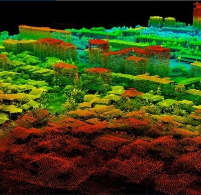
Point Cloud Analysis: Lidar data is often represented as a point cloud, which is a collection of points in 3D space. Lidar software can analyze point clouds to extract features such as terrain, buildings, and vegetation.
-
Classification and Segmentation: Lidar software can classify Lidar data into different categories, such as ground, vegetation, and buildings. This allows users to analyze different parts of the data separately.
-
Visualization: Lidar software can create 3D visualizations of Lidar data, allowing users to explore and interact with the data in a meaningful way.
Benefits of Lidar Software
Lidar software offers several benefits for users, including:
-
Increased Accuracy: Lidar software can process and analyze Lidar data with high precision, resulting in more accurate measurements and insights.
-
Time Savings: Lidar software can automate many of the data processing and analysis tasks, saving users time and effort.
-
Better Decision Making: Lidar software can provide valuable insights and information that can be used to make better decisions in various industries and applications.
-
Cost Savings: Lidar software can reduce the need for manual data processing and analysis, which can be expensive and time-consuming.
popular lidar software
Click here to login or register
Click here to login or register
Click here to login or register
Click here to login or register
Conclusion
Lidar software is a crucial component of Lidar technology, enabling users to process and analyze large volumes of Lidar data. From surveying and mapping to autonomous vehicles and robotics, Lidar software is used in a wide range of applications and industries. Its features and benefits make it a valuable tool for increasing accuracy, saving time and costs, and making better decisions. As Lidar technology continues to evolve, Lidar software will play an important role in unlocking the full potential of Lidar data.