

 GPS & GNSS
 Lidar scanning
 Total Station
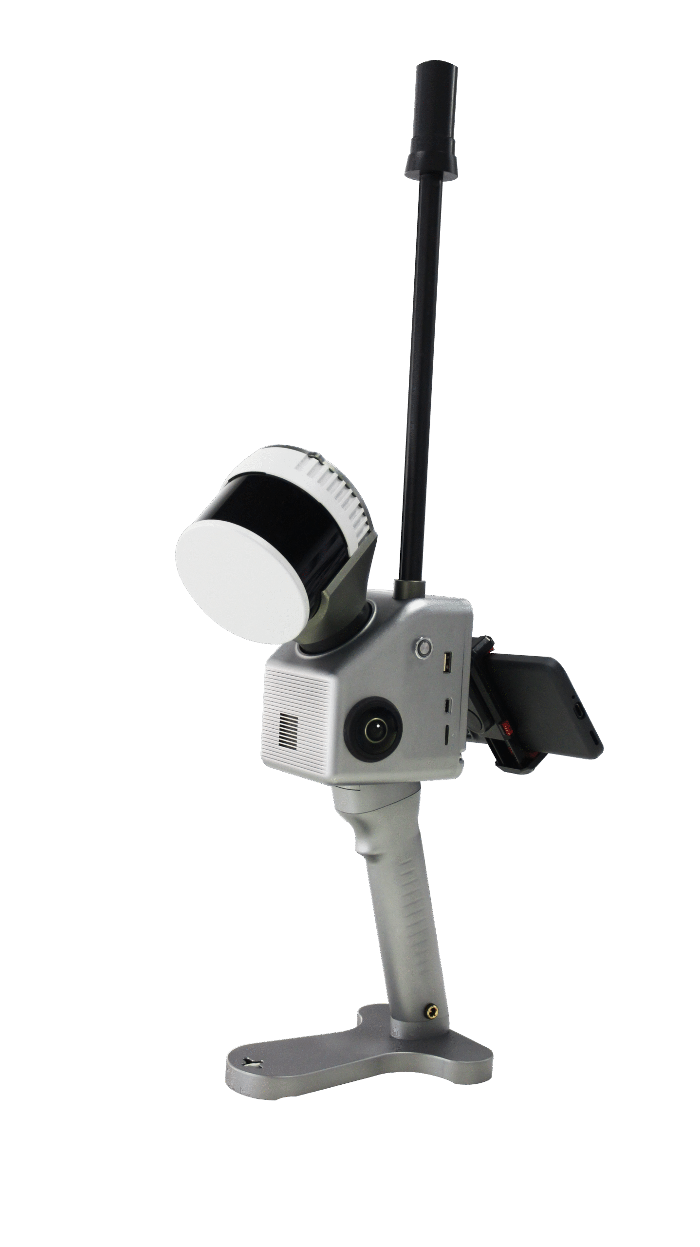
Geosun GS 130G 300m Handheld SLAM LiDAR Scanner
Get the best price for your setup
Contact our experts for the best possible price and configuration.
- Fast response
- Expert configuration advice
- No overpaying for features you do not need
The Geosun GS-130G is a lightweight multi-platform SLAM LiDAR scanner for fast 3D mapping indoors, outdoors and in areas where GNSS reception is limited. It combines a 32-channel LiDAR, GNSS/INS positioning, SLAM technology and dual 20 MP cameras in a compact 1.7 kg system. With a maximum measuring range of 300 m, triple returns, up to 1.92 million points per second and point-cloud accuracy of up to 5 cm, the GS-130G is designed for surveying, construction, mining, tunnels, façades, infrastructure, forestry and other professional reality-capture projects.
Geosun GS-130G Highlights
| Maximum LiDAR range | Up to 300 m |
|---|---|
| Point-cloud accuracy | ≤5 cm |
| Laser channels | 32-channel LiDAR |
| Point rate | Up to 1,920,000 points/sec |
| Laser returns | Triple echo |
| Field of view | 360° horizontal × 270° vertical |
| Cameras | Dual 20 MP RGB cameras |
| Mapping modes | SLAM, RTK-SLAM and PPK-SLAM |
| Weight | Approx. 1.7 kg |
Valued customers:










Find RTK Networks
Search NTRIP providers and connect to reliable RTK correction services.
Description
Professional SLAM LiDAR for indoor and outdoor 3D mapping
The Geosun GS-130G is a compact professional LiDAR scanning system developed for surveyors, engineers, construction teams, mining professionals, GIS users and reality-capture specialists who need to collect dense 3D data quickly. It combines a 32-channel laser scanner, GNSS positioning, an inertial navigation system, SLAM algorithms and high-resolution cameras in one integrated unit.
The GS-130G is designed to work across different environments rather than being restricted to conventional outdoor GNSS surveying. It can continue mapping indoors, underground, between buildings and in other areas where satellite reception becomes unreliable, while GNSS and RTK or PPK positioning can be used when suitable satellite coverage is available.
Up to 300 metre LiDAR range
A key advantage of the GS-130G is its maximum measuring range of up to 300 m. The manufacturer specifies approximately 80 m range on targets with 10% reflectivity, with the maximum distance achievable on more favourable reflective surfaces.
For field crews, the extended range is useful in larger environments such as mines, industrial halls, façades, tunnels, slopes and outdoor terrain. The operator does not need to move close to every surface to collect useful geometric information. As with any LiDAR system, practical range depends on target reflectivity, angle, environmental conditions and the required point density.
32-channel LiDAR with up to 1.92 million points per second
The GS-130G uses a 32-channel LiDAR sensor capable of recording up to 1,920,000 points per second in triple-return mode. The high point rate allows the scanner to capture dense information while the operator or platform is moving.
This is useful when recording detailed terrain, façades, structural elements, tunnel profiles, stockpiles, vegetation and industrial environments. A high acquisition rate also reduces the need to move extremely slowly through every part of the project just to achieve useful point coverage.
Triple returns for vegetation and complex objects
The scanner supports triple laser echoes. A single laser pulse can therefore provide information from several surfaces along its path. In vegetation, for example, returns may originate from the canopy, lower branches and surfaces below.
For forestry, terrain work and infrastructure surveys, multiple returns provide additional information that can help separate different height levels within the point cloud. The ability to reach the ground through vegetation still depends on canopy density and whether openings are available for the laser pulses.
SLAM mapping without continuous GNSS
The GS-130G uses SLAM technology to calculate its movement while simultaneously building a map of the surrounding environment. Rather than depending entirely on satellites, the system compares geometric features between successive scans to estimate how the scanner has moved.
This makes it suitable for tunnels, underground spaces, buildings, industrial facilities and other GNSS-denied locations. A surveyor can walk through a site while the system continuously records the surrounding geometry instead of stopping at numerous individual tripod positions.
SLAM RTK-SLAM and PPK-SLAM
The GS-130G supports SLAM, RTK-SLAM and PPK-SLAM workflows. Standard SLAM can be used where no useful satellite signal is available. RTK-SLAM adds real-time GNSS positioning where corrections and satellite reception are available, while PPK-SLAM allows positioning information to be processed afterwards.
This flexibility is especially useful on projects that move between open and enclosed areas. A survey may begin outdoors with GNSS positioning, continue inside a structure using SLAM and return outdoors without requiring a completely separate scanning system.
Integrated gSpin 210 GNSS and INS
The GS-130G incorporates Geosun’s gSpin 210 GNSS/INS positioning system with a 200 Hz update frequency. The GNSS unit supports GPS, GLONASS, Galileo and BeiDou satellite signals.
The published positioning specifications include approximately 2 cm horizontal and 3 cm vertical positioning accuracy under suitable GNSS conditions, together with 0.015° pitch and roll accuracy and 0.040° heading accuracy.
For georeferenced projects, this information helps connect the locally generated SLAM point cloud to the required coordinate system and improves continuity when working between indoor and outdoor areas.
Up to 5 cm point-cloud accuracy
The GS-130G is specified with point-cloud accuracy of up to 5 cm. Geosun also publishes an example of approximately 5 cm point-cloud accuracy at 100 m without control points.
This makes the system suitable for many surveying, mapping, documentation, volume and inspection tasks where rapid collection of a complete 3D environment is more important than millimetre-level static metrology. For work with strict engineering tolerances, control points and independent checks should still be used where required.
Wide 360 by 270 degree field of view
The scanner provides approximately 360° horizontal and 270° vertical coverage. This wide viewing geometry allows the GS-130G to record most of the environment surrounding the sensor while moving.
For building surveys this means walls, floors, ceilings and structural features can be captured together. In tunnels, mines and narrow corridors, surfaces around the operator can be collected without constantly changing the orientation of the scanner.
Dual 20 MP cameras for visual context
The GS-130G includes two 20 MP RGB cameras with wide image coverage. Camera data can be combined with the LiDAR measurements to create colourised point clouds and provide additional visual context for the captured geometry.
This makes it easier to recognise materials, signs, pipes, road markings, building features and other objects that can be difficult to distinguish in an uncoloured point cloud.
Handheld surveying and building documentation
In handheld mode, the GS-130G provides a fast way to capture existing conditions. Surveyors and construction professionals can walk through buildings, industrial sites and outdoor areas while recording complete surfaces rather than only selected points.
The resulting point cloud can support renovation work, building documentation, CAD or BIM workflows, dimensional analysis and site records. Because the complete surrounding geometry is captured, users can often return to the dataset later to inspect or measure features that were not the main focus during the original field visit.
Mining tunnels and underground surveying
Mining and underground environments are strong applications for SLAM because GNSS signals are generally unavailable. The GS-130G can be carried through mine workings, shafts, tunnels and underground infrastructure while its SLAM system maintains the local survey trajectory.
Geosun has demonstrated the GS-130G in demanding underground projects, including deep vertical-shaft mapping. The combination of long LiDAR range, wide field of view and GNSS-independent SLAM makes the system useful where conventional satellite-based surveying cannot operate continuously.
Façade and vertical-structure surveys
The 300 m maximum range and wide scanning geometry also make the GS-130G useful for façade and vertical-structure mapping. Buildings, retaining walls, towers and industrial structures can be documented from the ground while maintaining a practical distance from the object.
This can support architectural documentation, condition surveys, digital twins and 3D modelling where a complete representation of vertical surfaces is required.
Stockpiles earthworks and volume measurement
For mines, quarries and construction projects, the GS-130G can be used to capture stockpiles, excavations and changing terrain. Dense 3D surfaces can then be processed in compatible software for volume calculations and comparison between different survey dates.
Mobile SLAM collection can be particularly useful where frequent surveys are required and setting up a conventional static scanner at numerous locations would take unnecessary field time.
Multi-platform operation
One of the more flexible aspects of the GS-130G is its support for multiple operating platforms. Geosun lists handheld, backpack, UAV and vehicle configurations for the current system.
This means the same core sensor technology can be applied to pedestrian mapping, airborne surveys and mobile-mapping projects depending on the mounting hardware and project configuration. A survey company can therefore use the GS-130G for more than one type of reality-capture workflow.
Lightweight design for field crews
The current GS-130G weighs approximately 1.7 kg, including its battery in the published handheld configuration. This relatively low weight makes it easier to carry during longer surveys and also helps when integrating the system with UAVs or other mobile platforms.
The system provides approximately two hours of operating time, depending on configuration and operating conditions, and supports expanded microSD storage for larger survey projects.
Point-cloud processing workflow
Geosun provides its own point-cloud processing software for the SLAM product line. The recorded LiDAR, camera, GNSS and inertial information is processed to generate a usable georeferenced point cloud for further work.
After processing, the data can be used in compatible surveying, CAD, BIM, GIS, mining, engineering or specialist point-cloud applications depending on the final deliverables required by the project.
Who is the Geosun GS-130G for?
The GS-130G is particularly suitable for surveyors, construction companies, engineers, BIM specialists, mine operators, GIS teams, industrial inspection professionals and mobile-mapping companies that need one scanner for a wide range of indoor and outdoor environments.
Its main advantage is the combination of 300 m range, high point rate, SLAM, GNSS/INS and multi-platform operation. This makes it useful for professionals who need to move between conventional outdoor surveying and areas where GNSS equipment alone cannot maintain a reliable position.
Buying the Geosun GS-130G from Global GPS Systems
The right SLAM LiDAR configuration depends on the survey environment, required accuracy, working distance, control method, platform and final deliverables. Global GPS Systems can help determine whether the Geosun GS-130G is suitable for your project and advise on handheld, UAV or mobile configurations, GNSS integration and point-cloud processing workflows.
Datasheets & Manuals
Specifications
GeoSun GS-130 / GS-130G Handheld SLAM LiDAR Scanner Specifications
Product Overview
| Product name | GeoSun GS-130 / GS-130G |
|---|---|
| Manufacturer designation | GS-130G |
| Product family | GeoSun gFireEye Series |
| Product type | Lightweight handheld SLAM LiDAR scanning and mobile mapping system |
| System architecture | Integrated LiDAR, GNSS, INS/POS, RTK module, SLAM processing, mapping cameras, storage and battery |
| Current long-range LiDAR configuration | 32-channel Hesai XT-series sensor; current 300 m / triple-return configuration is documented with XT32M2X-generation hardware |
| POS / GNSS-INS | GeoSun gSpin 210 |
| Maximum measuring range | 300 m |
| Point-cloud accuracy | ≤5 cm |
| Maximum point rate | 1,920,000 points/second in triple-return mode |
| System scanning coverage | 360° horizontal × approximately 270° vertical |
| Mapping modes | SLAM, RTK-SLAM and PPK-SLAM |
| Primary platforms | Handheld, backpack, UAV / airborne and vehicle-mounted operation |
| Primary operating environments | Indoor, outdoor, underground and GNSS-denied or GNSS-challenged environments |
General System Performance
| Absolute point-cloud accuracy | ≤5 cm |
|---|---|
| Published accuracy reference | Approximately 5 cm at 100 m without control points in GeoSun international documentation |
| Maximum range | 300 m |
| Detection range at 10% reflectivity | 80 m on the current long-range configuration |
| Range accuracy | ±1 cm |
| Laser channels | 32 |
| Maximum returns | 3 |
| Maximum point rate | 1.92 million points/second |
| Battery duration | Approximately 2 hours |
| System power consumption | 25 W |
| Equipment weight | Approximately 1.7 kg |
| Operating temperature | -20°C to +55°C |
Mapping and Positioning Modes
| Mode | Positioning Method | Typical Application |
|---|---|---|
| SLAM | LiDAR and inertial SLAM without continuous external GNSS positioning | Buildings, tunnels, mines, underground areas and other GNSS-denied locations |
| RTK-SLAM | Real-time GNSS RTK positioning combined with SLAM | Georeferenced outdoor mapping and seamless outdoor-to-indoor surveying |
| PPK-SLAM | Post-processed GNSS trajectory combined with SLAM | Professional surveying where real-time corrections are unavailable or post-processing is preferred |
SLAM and Mapping Features
| Indoor mapping | Supported |
|---|---|
| Outdoor mapping | Supported |
| Indoor / outdoor seamless mapping | Supported |
| GNSS-denied mapping | Supported through SLAM |
| Integrated RTK | Yes |
| Extendable GNSS antenna | Supported |
| GeoSun SLAM algorithm | GeoSun proprietary industrial SLAM / ACG SLAM technology is documented for the GS-130G platform |
| Multi-platform mapping | One scanner can be used for terrestrial, backpack, airborne and vehicle-based acquisition |
| External mapping computer | Not normally required during handheld acquisition; the system is designed as a highly integrated standalone mapping payload |
LiDAR Specifications
| LiDAR architecture | 32-channel rotating mechanical 3D LiDAR |
|---|---|
| Current long-range sensor generation | Hesai XT32M2X-generation configuration |
| Measurement principle | Time of Flight (ToF) |
| Laser wavelength | 905 nm at sensor level |
| Laser class | Class 1 eye-safe at sensor level |
| Instrumented range | Up to 300 m |
| Range at 10% reflectivity | 80 m |
| Range accuracy | ±1 cm |
| Typical range precision | Approximately 0.5 cm, 1σ, at sensor level |
| Number of channels | 32 |
| Maximum return count | Triple return |
LiDAR Return Modes and Point Rate
| Return Mode | Sensor-Level Point Rate |
|---|---|
| Single return | 640,000 points/second |
| Dual return | 1,280,000 points/second |
| Triple return | 1,920,000 points/second |
LiDAR Native Optical Field of View
| Sensor horizontal FOV | 360° |
|---|---|
| XT32M2X vertical FOV | 40.3° (-20.8° to +19.5°) |
| Vertical channel spacing | Approximately 1.3° on XT32M2X hardware |
| GS-130G effective system horizontal coverage | 360° |
| GS-130G effective system vertical mapping coverage | Approximately 270° |
| FOV clarification | The approximately 360° × 270° figure is the complete GS-130G mapping-system coverage and should not be confused with the native optical FOV of the integrated LiDAR sensor |
LiDAR Frame Rate and Horizontal Resolution
| Frame Rate | Horizontal Resolution |
|---|---|
| 5 Hz | Approximately 0.09° |
| 10 Hz | Approximately 0.18° |
| 20 Hz | Approximately 0.36° |
LiDAR Data Interface
| Sensor data transmission | Ethernet |
|---|---|
| Ethernet interface | 100BASE-TX on XT32M2X sensor hardware |
| Measurements | Distance, azimuth and intensity |
| Sensor clock sources | GPS and PTP |
| PTP clock accuracy | ≤1 µs at sensor level |
| Single-return point-cloud data rate | Approximately 21.4 Mbps at sensor level |
| Dual-return point-cloud data rate | Approximately 42.8 Mbps at sensor level |
| Triple-return point-cloud data rate | Approximately 64.2 Mbps at sensor level |
GNSS / INS Position and Orientation System
| POS model | GeoSun gSpin 210 |
|---|---|
| Data update frequency | 200 Hz |
| Horizontal position accuracy | 0.02 m |
| Vertical position accuracy | 0.03 m |
| Pitch accuracy | 0.015° |
| Roll accuracy | 0.015° |
| Heading accuracy | 0.040° |
| Integrated GNSS module | Yes |
| RTK support | Yes |
| PPK support | Yes |
GNSS Signal Support
| Constellation | Current GeoSun Domestic Specification | Expanded International Documentation |
|---|---|---|
| GPS | L1 / L2 | L1 / L2 / L5 |
| GLONASS | L1 / L2 | L1 / L2 |
| Galileo | E1 / E5b | E1 / E5a / E5b |
| BeiDou | B1 / B3 / B2a | B1C / B1 / B2 / B2a / B2b / B3 |
Mapping Cameras
| Camera count | 2 |
|---|---|
| Camera resolution | 20 MP per camera |
| Combined camera configuration | 2 × 20 MP RGB |
| Horizontal camera coverage | Approximately 270° in GeoSun international documentation |
| Capture mode | Isochronous / synchronized image acquisition |
| Point-cloud colorization | Supported |
| Image georeferencing | Camera imagery can be synchronized with LiDAR and trajectory data |
Battery and Power
| Current manufacturer internal battery | 13,600 mAh |
|---|---|
| Current manufacturer external battery option | 19,000 mAh |
| Earlier / international datasheet battery | 11,600 mAh |
| Operating duration | Approximately 2 hours |
| Input voltage | 12–18 VDC in international GS-130G documentation |
| System power consumption | 25 W |
| Self-contained operation | Supported using the integrated battery |
Storage Specifications
| Current manufacturer internal flash | 64 GB |
|---|---|
| Current removable storage support | microSD up to 256 GB |
| International GS-130G documentation | 128 GB storage with microSD expansion up to 256 GB |
| Storage revision note | Published internal-storage capacity differs between hardware and regional documentation revisions |
Physical Specifications
| System weight | Approximately 1.7 kg |
|---|---|
| Weight condition | International manufacturer documentation specifies approximately 1.7 kg with battery |
| Housing material | Aluminum-alloy body in GeoSun product documentation |
| Form factor | Compact integrated handheld scanner |
| External backpack computer required | No for normal handheld acquisition |
| Published complete-system dimensions | Not specified in the reviewed current manufacturer GS-130G specification table |
Environmental Specifications
| System operating temperature | -20°C to +55°C |
|---|---|
| Complete-system IP rating | No numerical complete-system IP rating is stated in the reviewed current GS-130G specification |
| Indoor operation | Supported |
| Outdoor operation | Supported within system environmental limits |
| Underground operation | Supported |
| GNSS-denied operation | Supported through SLAM |
XT32M2X Sensor-Level Environmental Specifications
| Sensor operating temperature | -20°C to +60°C |
|---|---|
| Sensor storage temperature | -40°C to +85°C |
| Sensor ingress protection | IP6K7 |
| Sensor rated voltage | 9–36 VDC |
| Sensor typical power consumption | Approximately 10 W |
| Sensor weight | Approximately 0.49 kg |
| Sensor environmental-rating note | These ratings apply to the integrated LiDAR sensor itself and must not be treated as an environmental rating for the complete GS-130G system |
Supported Carrying Platforms
| Platform | Support | Typical Use |
|---|---|---|
| Handheld | Supported | Buildings, tunnels, mines, façades, heritage and general walking surveys |
| Backpack | Supported | Extended pedestrian surveys and hands-free mapping |
| UAV / airborne | Supported | Sky-to-ground surveying and low-altitude mapping with compatible mounting and aircraft integration |
| Vehicle | Supported | Mobile mapping, road surveys and urban data collection |
PointCloudCreater Processing Software
| Software | GeoSun PointCloudCreater / Point Cloud Creator |
|---|---|
| Primary function | SLAM point-cloud generation and preprocessing |
| Raw LiDAR processing | Supported |
| SLAM trajectory processing | Supported |
| RTK-SLAM processing | Supported |
| PPK-SLAM processing | Supported |
| Point-cloud colorization | Supported using synchronized RGB imagery |
| Georeferencing | Supported |
| Indoor / outdoor project processing | Supported |
| One-click / streamlined processing | Documented as part of the current GeoSun GS-130G workflow |
Point Cloud Automata
| Software | GeoSun Point Cloud Automata |
|---|---|
| Purpose | Point-cloud classification and post-processing |
| Classification | Supported with applicable software modules |
| Post-processing | Supported |
| Availability | Configuration- and license-dependent |
Typical Applications
| Application | Typical GS-130G Function |
|---|---|
| Topographic surveying | Rapid georeferenced 3D point-cloud acquisition |
| Building surveys | Indoor and exterior reality capture |
| BIM / Scan-to-BIM | Existing-condition capture for modelling and documentation |
| Digital twins | High-density spatial-data acquisition for digital representations of physical assets |
| Underground spaces | SLAM mapping where GNSS is unavailable |
| Mining tunnels and caves | Portable high-density underground 3D mapping |
| Vertical shafts | SLAM-based spatial capture of deep and GNSS-denied structures |
| Façade surveying | Detailed exterior-building point-cloud acquisition |
| Cultural heritage | Colorized 3D documentation of monuments, buildings and archaeological structures |
| Forestry | Tree, terrain and vegetation scanning from terrestrial and airborne platforms |
| Power-line inspection | Combined aerial and terrestrial mapping of power infrastructure and surrounding vegetation |
| Municipal engineering | Urban infrastructure and technical-cadastre data acquisition |
| Industrial facilities | Plant, equipment, pipework and structure reality capture |
| Road and street mapping | Vehicle-mounted or walking 3D corridor acquisition |
| Stockpile and volume surveys | Point-cloud acquisition for compatible volume-calculation workflows |
Transport and Packaging
| Item | Quantity | Notes |
|---|---|---|
| GS-130G SLAM LiDAR scanning system | 1 | Integrated LiDAR, GNSS/INS, camera, storage and battery system |
| Protective carrying case | 1 | Sturdy suitcase-style transport case documented by GeoSun |
| EVA protective liner | 1 | Installed inside the transport case |
| Outer shipping carton | 1 | Used around the protective case for shipment |
| GNSS antenna / extension | Configuration-dependent | The system supports an extendable GNSS antenna; exact supplied accessories should be confirmed |
| Backpack mounting system | Configuration-dependent | Supported operating configuration |
| UAV / vehicle mounting hardware | Configuration-dependent | Depends on selected carrying platform |
| Processing software licenses | Configuration-dependent | Confirm PointCloudCreater and optional Point Cloud Automata licensing with the supplied package |
Packaging Specifications
| Published carrying-case size | Approximately 450 × 365 × 200 mm |
|---|---|
| Case protection | EVA-lined protective suitcase |
| Outer protection | Hard shipping carton |
| Transport suitability | Manufacturer documentation identifies the packaging as suitable for air and sea shipment |
Current and Earlier GS-130G Hardware Documentation
| Specification | Current Long-Range Configuration | Earlier GS-130G Documentation / Case Material |
|---|---|---|
| Maximum range | 300 m | 120 m |
| Range at 10% reflectivity | 80 m | Approximately 80 m on XT32 hardware |
| LiDAR channels | 32 | 32 |
| Maximum returns | 3 | 2 on earlier XT32 configuration |
| Maximum point rate | 1,920,000 pts/s | Up to approximately 1,280,000 pts/s at sensor level; some earlier GeoSun application material quotes 640,000 pts/s |
| Integrated sensor generation | XT32M2X-generation long-range hardware | Earlier Hesai XT32 hardware |
| Point-cloud accuracy | ≤5 cm | ≤5 cm |
Published Configuration Differences
| Specification | Current GeoSun Manufacturer Page | International GS-130G Documentation |
|---|---|---|
| Product designation | GS-130G | GS-130G |
| Point-cloud accuracy | ≤5 cm | 5 cm at 100 m without control points |
| Weight | 1.7 kg | 1.7 kg with battery |
| Internal storage | 64 GB internal flash | 128 GB |
| microSD support | Up to 256 GB | Up to 256 GB |
| Internal battery | 13,600 mAh | 11,600 mAh |
| External battery | 19,000 mAh option documented | Not stated in the principal international specification table |
| Battery duration | 2 hours | 2 hours |
| GNSS signals | GPS L1/L2, GLONASS L1/L2, Galileo E1/E5b, BeiDou B1/B3/B2a | Expanded signal set including GPS L5, Galileo E5a and additional BeiDou frequencies |
| Maximum LiDAR range | 300 m | 300 m |
| Range accuracy | ±1 cm | ±1 cm |
| Maximum point rate | 1,920,000 pts/s triple return | 1,920,000 pts/s triple return |
| Cameras | 2 × 20 MP | 2 × 20 MP, approximately 270° horizontal coverage |
Documentation and Model Identification Notes
| Global GPS Systems product title | GeoSun GS-130 |
|---|---|
| Current GeoSun official model name | GS-130G |
| Manufacturer | Wuhan GeoSun Navigation Technology Co., Ltd. |
| Current manufacturer positioning | Lightweight handheld LiDAR scanning system with maximum range up to 300 m |
| Seller-page status at time of research | The Global GPS Systems GS-130 page identifies the product but does not yet publish a technical specification table; the specifications above therefore use current GeoSun GS-130G manufacturer documentation |
| Sensor-revision note | Older GS-130G field material documents a 120 m Hesai XT32 configuration, while current GeoSun specifications state 300 m, triple return and 1.92 million points/second, corresponding to the newer XT32M2X-generation configuration |
| Battery / storage revision note | Battery capacity and internal-storage figures differ between current domestic and international GeoSun publications; confirm the exact production configuration before specifying runtime or storage capacity |
| System-versus-sensor FOV note | The 360° × 270° mapping coverage is a complete-system specification and is not the native optical FOV of the integrated 32-channel LiDAR sensor |
| Final configuration requirement | For guaranteed accuracy, battery capacity, GNSS signal support, sensor revision, storage and accessory contents, use the serial-number-specific datasheet and calibration information supplied with the exact unit |
Specifications and package contents may vary by configuration, region or manufacturer update. Always check the current configuration before ordering.
Reviews (0)
Only logged in customers who have purchased this product may leave a review.
FAQ
GeoSun GS-130 LiDAR Scanning System FAQ
GS-130, Applications & Surveying
What is the GeoSun GS-130?
The GeoSun GS-130 is a compact professional LiDAR mapping system designed for UAV and mobile surveying. It integrates a 32-channel laser scanner, multi-frequency GNSS, an inertial navigation system, onboard storage and a 26 MP mapping camera to collect georeferenced 3D point clouds and colour imagery.
What is the GeoSun GS-130 used for?
Typical applications include topographic surveying, land surveying, power-line inspection, corridor mapping, forestry, agriculture, construction surveys, mining, water-conservancy projects, smart-city mapping and other projects requiring accurate 3D spatial information.
Is the GeoSun GS-130 designed for drone LiDAR surveying?
Yes. The GS-130 is designed as a lightweight airborne LiDAR mapping payload for compatible professional UAVs. Its integrated GNSS, INS, LiDAR and camera allow position, orientation, laser measurements and imagery to be recorded together during a flight.
Can the GeoSun GS-130 also be used for vehicle-based mobile mapping?
Yes. The GS-130 can also be installed on a suitable vehicle for mobile mapping. Its 360-degree horizontal LiDAR coverage can capture roads, kerbs, buildings, vegetation, utilities and surrounding infrastructure while the vehicle is moving.
Can the GS-130 survey areas with dense vegetation?
Yes. The 32-channel LiDAR supports multiple returns and has a small laser beam divergence, making it suitable for forestry and vegetation-rich terrain. Multiple returns can record different surfaces along the laser path, improving the possibility of obtaining ground measurements through gaps in vegetation.
Who is the GeoSun GS-130 designed for?
The GS-130 is designed for professional land surveyors, UAV mapping companies, geospatial specialists, engineers, forestry professionals, utility inspection teams, mining companies and organisations that need efficient high-density LiDAR data collection.
LiDAR Range, Accuracy & Point Cloud Performance
What is the measurement range of the GeoSun GS-130?
The GS-130 provides a LiDAR measurement range of up to approximately 120 metres under the specified operating conditions. Actual usable range depends on target reflectivity, atmospheric conditions, scan angle, surface characteristics and the accuracy required for the project.
How accurate is the GeoSun GS-130?
GeoSun specifies complete system accuracy of approximately 5 cm at 50 m and approximately 10 cm at 100 m under suitable survey conditions. Final accuracy depends on GNSS satellite geometry, INS performance, flight conditions, system calibration and post-processing.
What is the LiDAR ranging accuracy of the GS-130?
The laser scanner has a specified range accuracy of approximately ±0.5 cm under suitable conditions. This describes the accuracy of the distance measurement itself rather than the absolute accuracy of the final georeferenced point cloud.
What is the difference between LiDAR range accuracy and system accuracy?
Range accuracy describes how accurately the LiDAR measures the distance between the sensor and a surface. System accuracy describes the accuracy of the final X, Y and Z point coordinates and also includes GNSS positioning, aircraft attitude, time synchronization, mounting calibration and trajectory-processing errors.
How many points per second can the GS-130 collect?
The GS-130 can generate up to approximately 1,280,000 LiDAR points per second. This high measurement rate helps create dense point clouds for terrain, vegetation, structures, roads and utility infrastructure.
Does the GS-130 support multiple LiDAR returns?
Yes. The GS-130 supports dual-return LiDAR measurements. Multiple returns are useful in environments such as forests because one laser pulse can potentially record information from vegetation as well as another surface farther along the same laser path.
What field of view does the GeoSun GS-130 provide?
The GS-130 provides full 360-degree horizontal LiDAR coverage with approximately 31 degrees of vertical coverage. This allows it to capture terrain directly below the platform as well as oblique and vertical features surrounding the flight or vehicle path.
GNSS, INS, Camera & Data Processing
Does the GeoSun GS-130 include GNSS and an INS?
Yes. The GS-130 integrates GeoSun's positioning and orientation system with multi-frequency GNSS and an inertial measurement unit. The system records the position, pitch, roll and heading of the LiDAR throughout the survey so each laser measurement can be transformed into a georeferenced 3D coordinate.
Which GNSS constellations does the GS-130 support?
The integrated GNSS system supports multiple frequencies from GPS, GLONASS, Galileo and BeiDou. Multi-constellation tracking improves satellite availability and provides the observations required for high-precision trajectory processing.
What is the GNSS/INS positioning accuracy of the GeoSun GS-130?
The current positioning system specifies approximately 0.02 m horizontal and 0.03 m vertical position accuracy under suitable processing conditions. Pitch and roll accuracy are approximately 0.015 degrees, while heading accuracy is approximately 0.040 degrees.
What is the GNSS/INS update rate of the GS-130?
The integrated positioning and orientation system operates at up to 200 Hz. This high update frequency is important because a UAV or vehicle can change position and orientation rapidly while LiDAR measurements are being collected.
Does the GeoSun GS-130 include a camera?
Yes. Current GS-130 configurations include a 26 MP mapping camera with an approximately 83-degree field of view. The camera imagery can be synchronized with the LiDAR survey and used to create colourized point clouds and provide additional visual information for interpretation.
What software is used to process GeoSun GS-130 data?
GeoSun provides software for processing the recorded GNSS/INS trajectory and LiDAR observations. Shuttle is used for high-precision trajectory processing, while GeoSun point-cloud software such as gAirHawk can combine the processed trajectory with the LiDAR data to generate georeferenced point clouds.
Which point cloud formats can GeoSun GS-130 data be exported to?
The GeoSun processing workflow supports industry-standard LAS point-cloud output as well as custom TXT data. LAS files can be imported into many professional surveying, GIS, CAD, forestry and point-cloud processing applications.
UAV Integration, Storage & Field Operation
How much does the GeoSun GS-130 weigh?
Current GeoSun specifications list the GS-130 system at approximately 1.4 kg. The UAV payload calculation should also include the mounting hardware and any additional components required by the complete installation.
How large is the GeoSun GS-130?
The GS-130 measures approximately 14.2 × 10.9 × 12 cm. Its compact integrated design combines the LiDAR, positioning system, camera, storage and control electronics into one relatively lightweight mapping payload.
How much onboard storage does the GS-130 provide?
The GS-130 includes approximately 64 GB of internal storage and supports a TF or microSD card with a capacity of up to approximately 256 GB on current configurations. Required capacity depends on mission duration, point-cloud density and the amount of imagery being recorded.
What power supply does the GeoSun GS-130 require?
The GS-130 operates from approximately 12 to 24 VDC and has a specified system power consumption of around 20 W. The UAV or vehicle power system should provide a stable supply throughout the complete data-collection mission.
What is the operating temperature range of the GS-130?
The specified operating temperature range is approximately -20°C to +55°C. The complete mapping platform, including the UAV, batteries, GNSS antenna and other equipment, must also remain within its own specified environmental limits.
What should be considered before mounting the GS-130 on a drone?
The UAV must have sufficient payload capacity, stable power output and a rigid mounting system with an unobstructed LiDAR field of view. The position and orientation between the LiDAR, GNSS antenna, INS and camera must be accurately calibrated. Flight altitude, speed, overlap, terrain, required point density and applicable aviation regulations should also be considered when planning the survey.
 GPS & GNSS
 Total Stations
 Data collectors
 Software
 Correction services
 Machine control
 External radio
 Marine
 Accessories
Reviews
There are no reviews yet